(Cross-posted at West Michigan Rising, Daily Kos, and Michigan Liberal-PB)
Introduction
In recent months astute political analysts have noted that the real prize in the 2010 election is control of the redistricting process that will follow in the year to come. While redistricting occurs on every level of government throughout the 50 states, many observers note the importance of redistricting United States House Districts. In the 2001-2002 redistricting cycle following the 2000 Census, many states, including Texas and Pennsylvania, underwent an aggressive Republican gerrymandering developed to maximize GOP gains in 2002 and 2004. This strategy largely succeeded, allowing the Republicans to further their control of many state delegations.
Perhaps the most aggressive GOP redistricting (with the exception of Tom Delay’s Texas redraw) came in Michigan. Since the adoption of the 1964 Constitution, the state legislature has controlled the redistricting process, with the governor having veto power over the plan. The redistricting plans offered in 1965, 1971, 1981, and 1991 by the state legislature were rejected by the federal courts, which decried the partisan nature of both the Democratic and Republican plans. Given that the Republicans controlled the State Senate during each of four cycles (and the Democrats controlling the State House), the plans that were eventually approved by the federal courts strived to adhere to the 1964 State Constitution’s demand that districts be “compact, contiguous, and avoid breaking up political subdivisions (such as municipalities).”
This situation did not repeat itself in 2001. The Michigan Republican Party, which controlled the executive branch starting in 1990 and the State House in 1995, while maintaining its hold on the State Senate, drafted new legislation to guide the redistricting of federal and state legislative districts. MCL 3.61 (PA 221 1996) often known as the Congressional Redistricting Act, guided redistricting of congressional seats, while State Legislative Redistricting Standards Act (MCL 4.261) charted redistricting of the State House and Senate. Both laws largely adopted the standards established by the Michigan Supreme Court during the previous redistricting battles.
In regards to congressional redistricting, MCL 3.61 establishes the following requirements. First, the principle of “least cost” holds throughout, and states that municipalities should be incorporated within districts if the population of a municipality is smaller than the size of an average Congressional District. Secondly, populations for Congressional districts must equal (MCL 3.63d). Finally, the preservation of municipal and county identity is encouraged, and district lines should be drawn on municipal or county boundaries (3.61g).
Since the GOP controlled all three branches of the state government in 2001, the Republican drawn redistricting plan upheld by the Michigan Supreme Court in the same year had profound effects on Michigan Congressional Representation. The state lost a seat, and two Democratic incumbents were thrown into one district (John Dingell and Lynn Rivers), while a number of marginal seats were stacked with Republicans. While the Michigan Delegation had 9 Democrats and 7 Republicans prior to the 2002 elections, afterwards the GOP held 9 of 15 seats. Despite two Democratic tidal wave in the 2006 and 2008 elections, the Democrats only gained two seats, and currently hold a 9 to 7 edge in the Congressional delegation.
As 2010 approaches, it appears that the Democrats will likely control at least one leg of the redistricting chair. The 67 to 43 Democratic edge in the State House is likely to ensure that the Democrats will remain the majority party in the lower chamber. While the gubernatorial race remains an open contest, the Michigan Democratic Party has made a serious effort to recapture the State Senate, something which has not happened since the tax-revolt elections in 1984. Should the Democrats gain four seats (The current margin is 21 Republicans to 16 Democrats with one open seat), the Democrats will be in solid control of the redistricting process. Given that the Michigan State Supreme Court also has a Democratic majority it is likely that a reasonably drawn plan by a Democratic legislature adhering to MCL 3.61 would receive judicial sanction.
Two previous redistricting efforts have been made on the blosphere redraw Michigan’s congressional districts. Both (rightly so) assume that Michigan will lose one congressional district after the 2010 Census. The first, drawn by Menhen and was first posted on the Swing State Project creates 11 safe Democratic seats and three Republican districts. The second, drawn by ArkDem, and also posted on the Swing State Project, that provides 10 Democratic seats with four Republican districts. With both redistricting plans are ingenious, and do an excellent job at screwing the GOP, both have some flaws that limit their usefulness. First, the vote analysis relies on the Presidential vote percentages from the 2008, which represents the strongest Democratic vote percentage in Michigan since Johnson’s landslide in 1964. Obama’s excellent performance should be viewed as a high watermark of the Democratic vote in 2008, as his opponent has effectively conceded the state in early October. Thus, Obama’s decisive win in Michigan makes the state appears far more Democratic than it really is. Likewise, there is no examination of the Democratic performance in previous election cycles, which hinders a long-term analysis of how stable Democratic majorities are in the proposed Congressional Districts. Finally, voters tend to vote for the candidate for races on the top of the ballot (such as in the Presidential, Senate, and Gubernatorial races) that limits the effectiveness of using this data for determining the underlying partisan affiliation of a proposed district.
Methodology
I created a redistricting plan that tries to avoid some of the pitfalls mentioned earlier. First, rather than using the Obama vote percentage in 2008, I used another indication to determine the underlying Democratic partisan edge. While Michigan does not have partisan registration, it does have a wonderful obscure State Board of Education (BOE) that has eight members, of which two are elected every two years. Each party is allowed to nominate two candidates, and the top two vote getters join the BOE. BOE races often have candidates largely unknown by voters, who generally vote according to their partisan preference. I calculated the Republican and Democratic baseline by finding the average Democratic share of the vote cast for the two major parties. I calculated the Democratic Baseline on the municipal and county level for the 2000, 2002, 2004, 2006, and 2008 elections. Mark Gerbner, the famous guru of Michigan Democratic politics helpfully provided the raw data for all but the 2008 election cycle, which I tabulated myself from the Michigan Secretary of State website. The Democratic Baseline generally runs slight behind successful top of the ticket candidates (such as Obama, Granholm and Levin), but provides an elected approach to examining long-term voting trends within communities across the state.
I used Census Data from the 2007 American Community Survey (ACS) to determine the current population of municipalities in Michigan. With Michigan’s current population at 10,287,460, I calculated that each congressional district needs to have 734,818 residents. Under MCL 3.63, each district is allowed to have a 5% variation (ranging from 95% to 105% of the average), giving each district a population range of 698,077 to 771,558. In Google Docs I provide the county level voting data for each district, and when I need to divide further, I provide the municipal data. The link can be found below:
http://spreadsheets.google.com…
All the maps were created in ArcGIS 9.3, which I use for my career and for fun.
Analysis
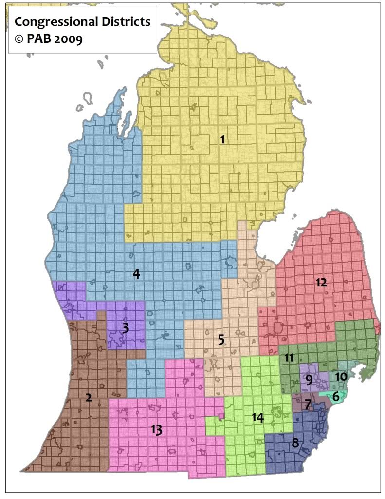
http://i303.photobucket.com/al…
The overall state map is shown above without the Upper Peninsula, which is part of the 1st Congressional District.
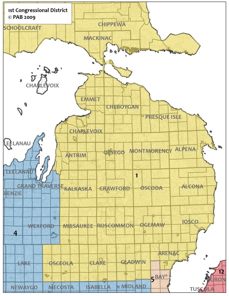
http://i303.photobucket.com/al…
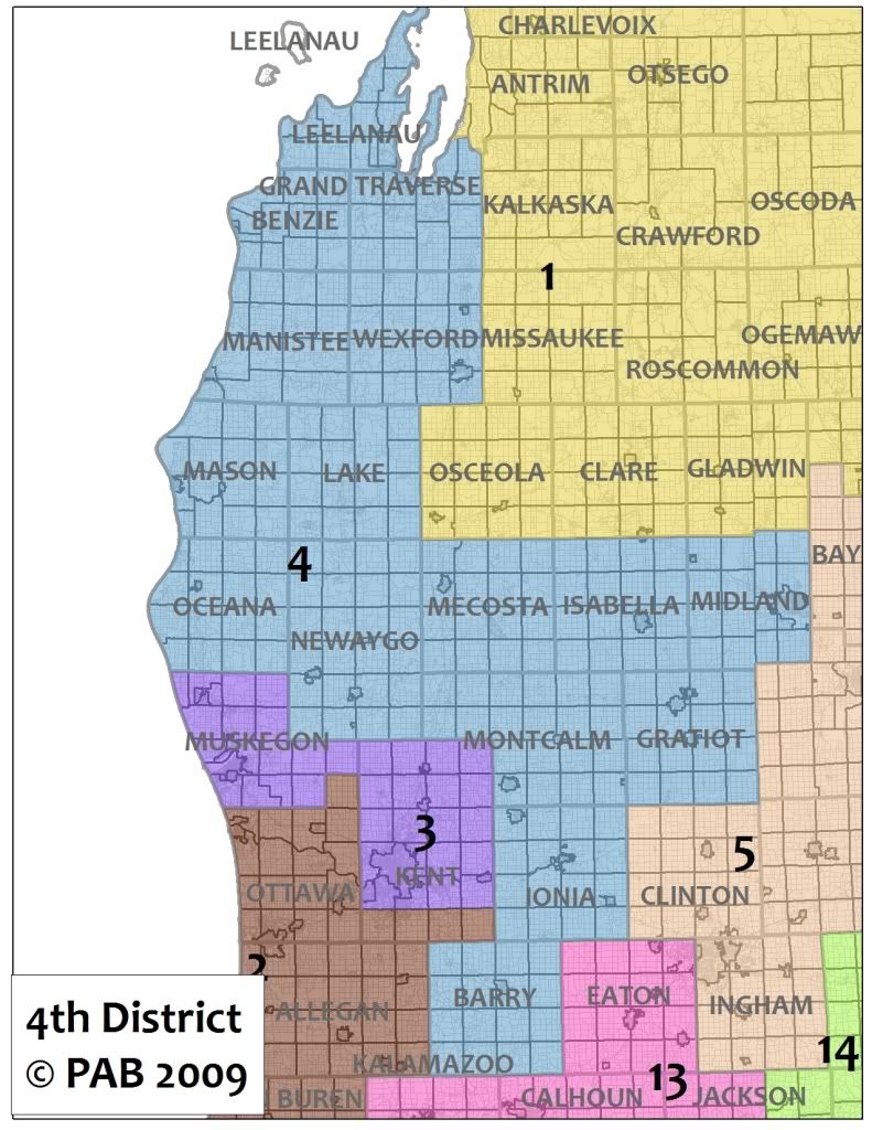
1st Congressional District (2008 Democratic Baseline of 53%). The First Congressional District is relatively similar to its 2001 incarnation, with a few moderate changes. The district loses Bay County, and gains some smaller rural counties on the western edge of the district from David Camp’s district. Stupak has always done very well in the 1st District, and ran 3% ahead of the Democratic Baseline in his current district. He will likely continue to do well in the new district, although the Democratic Baseline dropped slightly below 50% in 2004 and 2002, two very Republican years. Until Stupak retires, it will be hard for a Republican to win this district.
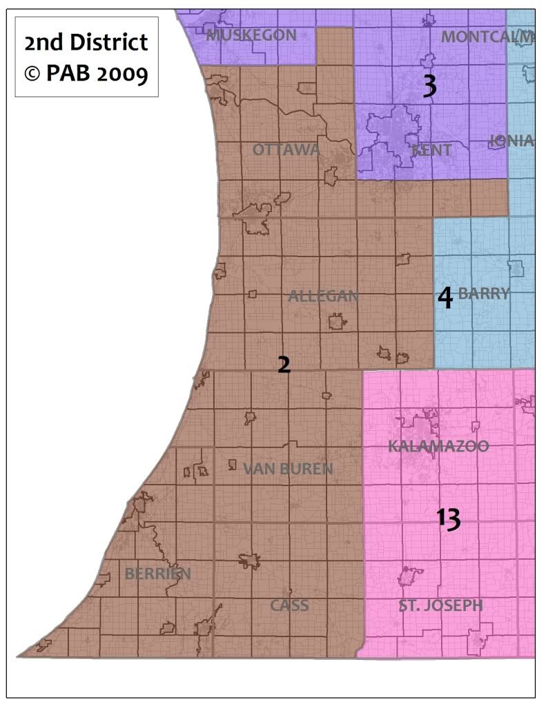
http://i303.photobucket.com/al…
2nd Congressional District (2008 Democratic Baseline of 40.2%). This is one of the three safe Republicans seats in Michigan. Essentially this new seat flips Republican Pete Hoekstra’s current 2nd District, running from GOP bastion Ottawa County south along the Lake Michigan shoreline. The district would take a majority of the 6th District (represented by Republican Fred Upton), moving Cass, Berrien, Van Buren, and Allegan Counties to Ottawa County and the four southern townships in Kent County (Byron, Gains, Caledonia, and Bowne Townships). The new 2nd District would likely force the current 2nd District Representative (whoever replaces Pete Hoekstra in 2010) into a nice runoff against Fred Upton, who lives in Berrien County (St. Joseph). I would suspect that Upton would be able to win a primary, and given that he is a relative moderate in the GOP caucus, it would be beneficial long-term for moderates in the GOP.
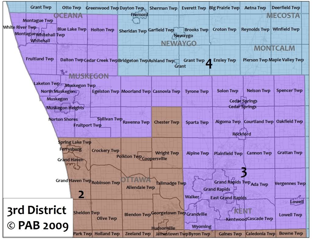
http://i303.photobucket.com/al…
3rd Congressional District (2008 Democratic Baseline of 52.7%). This district is a likely swing seat since Muskegon and Kent Counties (minus the southern four townships) have trended Democratic over the past decade, and Obama carried 54.5% of the total vote in the two counties. An important case can be made for congressional districts that follow regions land use patterns, and this district certainly encompasses the heart and soul of western Michigan. This proposed 3rd district allows for issues addressing the urban core (Grand Rapids and Muskegon), and provide two centers of Democratic voters that gave baselines of 64% and 72% respectively. The district loses the largely rural counties of Ionia and Barry, allowing for strong economic development efforts for metropolitan Grand Rapids. On an off-Democratic year this seat may be difficult for the Democratic Party to hold, but it also provides an excellent excuse for further party building. Some strong Democratic candidates would be former State Representative Steve Pestka or Scott Bowen. Should current Republican Representative Vern Ehlers retire, the GOP primary battle would be between Secretary of State Terri Lynn Land and State Senator Bill Hardiman. However, to run competitively in this district the GOP will need to find candidates that can speak on urban and metropolitan issues, something which the party of no has a difficult time even thinking about.
http://i303.photobucket.com/al…
4th Congressional District (2008 Democratic Baseline of 47.5%) While this district is slightly less Republican than the 2nd, it is the third most Republican district in the state. Moving westward from the current 4th District, it collects the portions of the 2nd District north of Muskegon County, follows the current district boundaries to Midland County, and gains Ionia and Barry Counties. Like the current 4th, the district mostly consists of rural areas, along with a few mid-side cities, including Midland, Big Rapids, and Traverse City. This district will likely reelect Republican David Camp.
http://i303.photobucket.com/al…
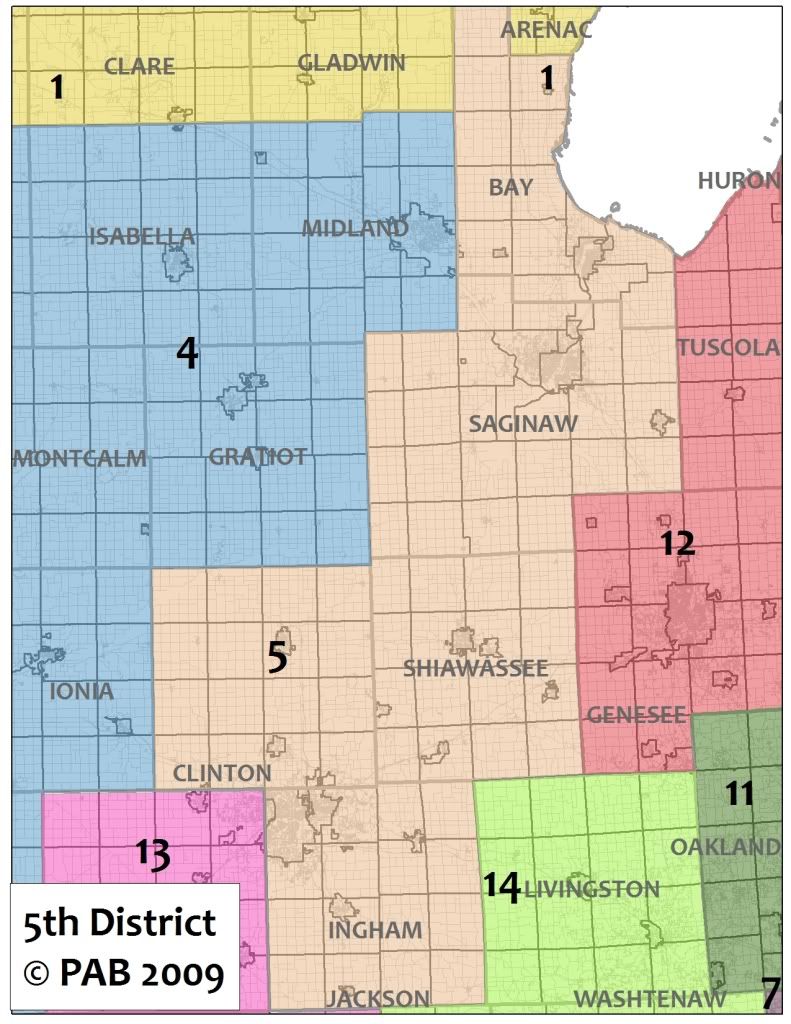
5th Congressional District (2008 Democratic Baseline of 60.8%). This is among the most reconfigured districts from its 2001 incarnation. While the current 5th district covers Genesee, Tuscola, and portions of Bay and Saginaw Counties, the new 5th includes Bay, Saginaw, Clinton, Shiawassee, and Ingham Counties. Much like the existing 5th District, it is a Democratic stronghold, but unlike the current 5th it steals the western half of Republican Mike Rodgers gerrymandered seat and restores its Democratic edge. This district combines the urban centers of Lansing, Saginaw, Bay City, and will be easily held by a Democratic candidate like Lasing Mayor Virgil Bernero or former Democratic Representative Jim Barcia. Good luck to any Republican running in this safe Democratic seat.
http://i303.photobucket.com/al…
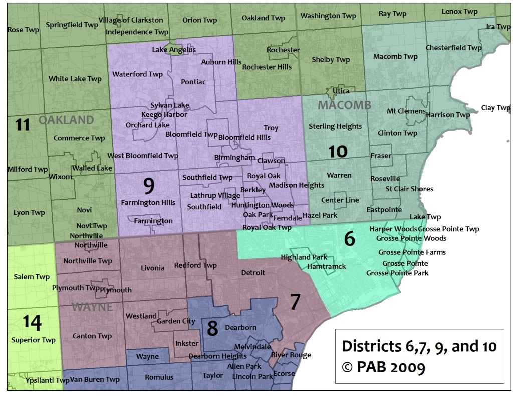
6th Congressional District (2008 Democratic Baseline of 90.3%). Similar to the current 13th Congressional District, this district reflects the painful reality that Detroit continues to lose population. According to the 2007 ACS, Detroit’s population is 916,000, and I suspect it might fall below 900,000 by 2010. The 6th District contains the eastern Wayne County suburbs, Highland Park, Hamtramck, and two-thirds of the city of Detroit. This seat is a safe Democratic stronghold, and complies with the Voting Rights Act by being a minority-majority district. Let’s hope that State Senator Martha Scott once again primaries Carolyn Kirkpatrick.
7th Congressional District (2008 Democratic Baseline of 72.5%). The 7th District is a greatly modified version of the 14th District currently represented by Democratic Congressman John Conyers. The new district includes the western third of Detroit, and the western Wayne County suburbs of Redford Township, Livonia, Canton Township, Westland, Garden City, Inkster, Northville City and Township, and Plymouth City and Township. While this district is much less Democratic than the 6th District, it is still a strong Democratic seat that accomplishes the beautiful task of eliminating Republican Thad McCotter’s seat. McCotter could try to run against Conyers (or State Senator Buzz Thomas should Conyers retire), but he’d lose. Too bad.
http://i303.photobucket.com/al…
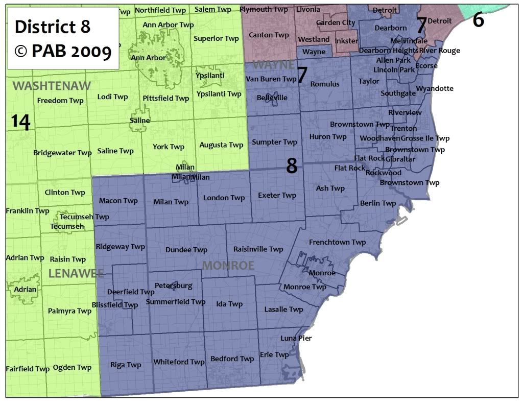
8th Congressional District (2008 Democratic Baseline of 65.3%). Much like John Dingell’s 15th District, this seat is a strong suburban working-class district that covers southern Wayne County, Monroe County, and a portion of eastern Lenawee County. While the new 8th Congressional District loses Ann Arbor and its surroundings, the new district remains a strong Democratic seat, anchored by Democratic communities in Dearborn, Monroe, and Romulus. While it remains unlikely that Dingell will stay in US House much longer, I would not be surprised to see Debbie Dingell run for this seat when John retires. It would be hard to see a Dingell lose this safe Democratic seat to a Republican.
9th Congressional District (2008 Democratic Baseline of 63.6%). The new 9th District is all about providing incumbency protection for Democratic Representative Gary Peters. Peters currently represents much of Oakland County, and this redraw would add the southern portions of the county that are currently represented by Democratic Representative Sander Levin. This district would shed the conservative northern suburbs of Rochester and Rochester Hills and would become increasingly Democratic. Even in the Republican year of 2002, this safe Democratic seat still had a Democratic Baseline of 54.4%.
10th Congressional District (2008 Democratic Baseline of 60.2%). This district covers the southern portion of Macomb County. Much like former Democratic Representative David Bonior’s old Macomb County seat, this district would be a working class Democratic stronghold, providing two districts (the 8th and the 10th) that would be platforms for labor voices to be heard from Michigan. Sander Levin will have no problem holding this safe Democratic seat.
http://i303.photobucket.com/al…
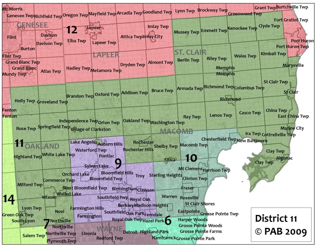
11th Congressional District (2008 Democratic Baseline of 46.0%). This safe Republican seat would give Representative Candice Miller a vastly new district to represent, which is good for her. Covering the northern and western portions of Oakland County, northern Macomb County, and much of St. Clair County, this district has some suburban communities along with a strong rural character. This district is the third safe Republican seat in the state.
http://i303.photobucket.com/al…
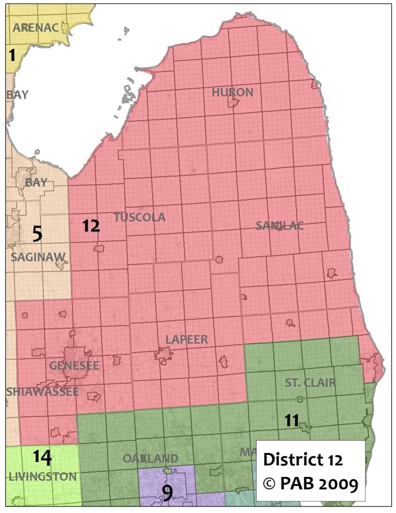
12th Congressional District (2008 Democratic Baseline of 61.7%). This is a modified version of Dale Kildee’s current 5th Congressional District, and is centered in Genesee County. Many people don’t know that the “thumb” of Michigan is a pretty swing district, and adding Huron, Tuscola, Lapeer, Sanilac Counties, and a portion of St. Clair County (largely metropolitan Port Huron) would not significantly dent the Democratic base around greater Flint. This district has a a couple major urban centers, but is largely rural as well, which might call for some vigorous constituency work to ensure the Democrats holding this seat.
http://i303.photobucket.com/al…
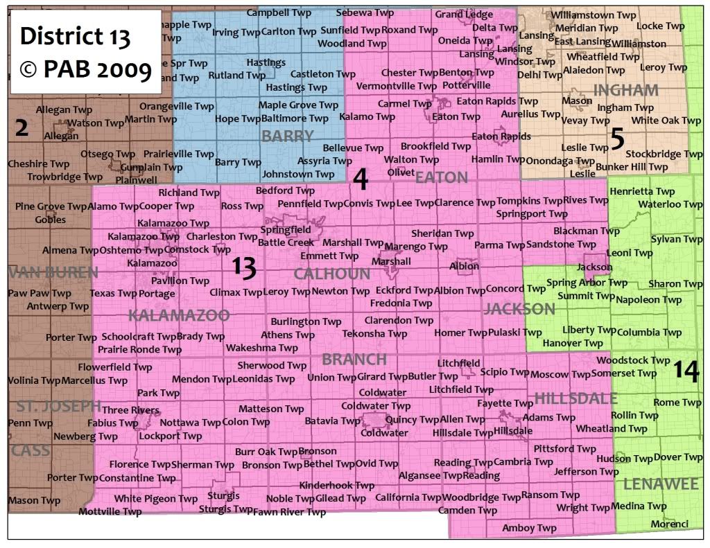
13th Congressional District (2008 Democratic Baseline of 54.3%). Much like Gary Peter’s 9th District, Democratic Representative Mark Schauer won election to a traditionally Republican district. Should Schauer win reelection in 2010, his district should shed some GOP votes and pick up some Democratic voters. The new 13th District does just that, losing a portion of Jackson County and Washtenaw County that are largely Republican. In return, the district adds Kalamazoo and St. Joseph Counties, the latter, along with Calhoun County, provides a strong Democratic base for the 7th District. This district, while increasingly Democratic, was a swing seat from 2000 to 2006, giving it swing district status on an off year. Given that Schauer has done a great job in the State Senate and in 2008 in running effective constituency service and electoral campaigns, a GOP would need a determined candidate to knock him off. Someone more likable than Taxing Tim Walberg would be needed.
http://i303.photobucket.com/al…
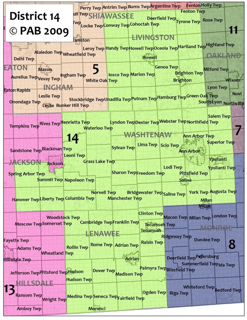
14th Congressional District (2008 Democratic Baseline of 57.6%). This District covers Livingston and Washtenaw Counties, while also including portions of Lenawee and Jackson Counties. Largely rural, the district’s heart is Ann Arbor, which provides the Democratic base for this seat. A strong Democratic candidate from eastern Washtenaw County could win this district, although he or she would need to appear to the conservative Livingston County voters. That said, this new district would invite Republican Representative Mike Rogers to run a losing campaign to hold his seat. This isn’t Mr. Rogers neighborhood anymore.
Conclusion
This proposed 2011 redistrict makes Michigan’s congressional boundaries much more friendly for Democratic candidates. There are seven safe Democratic seats (Districts 5, 6, 7, 8, 9, 10, and 12), one strongly Democratic District (District 14), and two leaning Democratic Districts (District 1 and 13), giving the MDP 10 Congressional Seats. The Michigan Republicans would have three safe seats (Districts 2, 4, and 11), while the 3rd Congressional District is arguably a swing seat.
This proposal also forces many GOP incumbents into retirement, which is something a good plan always does. Forcing Upton to run against Hoekstra’s replacement in the new 2nd District, and placing Mike Rogers and Thad McCotter into unwinnable seats is something sure to give Democratic loyalists a smile on Election Day. Should the Michigan Democrats win control of the Michigan State Senate in November 2010, 10 Democratic Congressional seats are a real possibility.
Isabella County is home to Michigan State University and it gave Obama 59% of its vote. I have seen another Michigan redistricting plan that puts Isabella in the 1st, and I think that’s a good idea. You can trade it for Osceola, Missaukee, and Kalkaska, all voted for McCain. It will change the shape of the 4th, making it look more gerrymandered, and it’s clear you’re trying to avoid that, but I think it’s worth it.
This has got to be the best redistricting plan I have seen for any state on this site. I really admire everything it achieves: keep counties and cities together, compact reasonable shapes, and it certainly looks fair. And with all that you still get a likely 11-3 Democratic advantage. Also I think a Democrat will be able to win the 11th in a few more election cycles.
I especially like what you did with Mike Rogers district. You did draw Sander Levin and Gary Peters into a district together but Levin would probably run in the 10th. One thing you should probably consider is that it seems like voters are more likely to support Democrats on education than on other issues (for example how in South Carolina Superintendent of Education is the only office we can seem to win, or in Arizona how in 2006 some dude almost upset Republican SoE Tom Horne even as Democrats completed phailed in statewide offices that weren’t Governor or AG). I would agree that it’s still a better measure of that state of Michiganders political leanings than Obama’s 2008 performance.
What made the Republican gerrymander in 2002 powerful was that it didn’t seem like a gerrymander. Looking at the numbers, it obviously was, but looking just at the map, it looks like everything flows fairly naturally, and it meets all of the guidelines in the law that you mention in your diary. It’s hard to get people angry about something so smooth.
That’s exactly what your map does, and if we hold the governor’s mansion and take the state Senate, I hope that something similar to this map will be the end result.
This is the best and most researched redistricting diary that I’ve seen. You win.
You achieved the correct mixture of gaining seats without endangering our incumbents or creating a Picasso map.
What helps a lot with MI is that most of the counties are nice and square, so one can create very favorable districts without it looking that way.
BTW, I gave up on doing a map of OH because I couldn’t get the populations right. Perhaps doing such a big state as a first-time redistricter was too ambitious.
I’ve since shifted my attempts to Oregon, using ArkDem’s map as a guide. However, I have a question: How do I get my state and area maps to SSP from the App?