This is part three of a series on the political structure of the swing state Florida.
The I-4 Corridor
If there is a holy grail of Florida politics, it is winning the I-4 corridor. This refers to the Interstate 4 highway, which begins in Tampa Bay, travels though Orlando, and ends in Daytona Beach.
Quite a lot of people live in the I-4 corridor. It’s far more populated than northern Florida (and northern Florida itself is relatively dense compared to other parts of the South). While parts of south Florida are far more people-heavy, as an aggregate central Florida has a slightly greater population. The I-4 corridor can be compared to a gigantic suburb, with an unusually high number of retirees. Granted, there are cities, but they are more alike to Phoenix (which is really just a big suburb with skyscrapers) than New York.
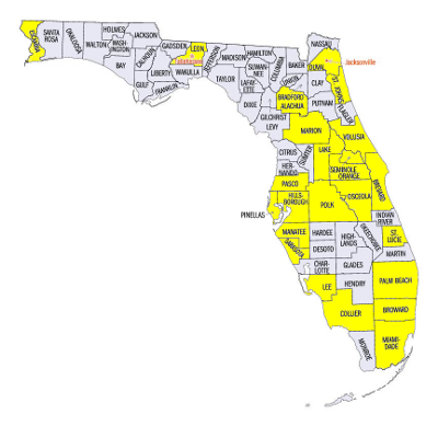
The picture above indicates counties in which more than 100,000 votes were cast in 2008; it is a rough indication of voting density. There are a scattering of counties with more than a hundred thousand voters in northern Florida; actually Obama does quite well in the highlighted counties. Most of south Florida is also yellow. Then there is an empty region – the Everglades. And above that is the I-4 corridor, which is nearly entirely highlighted. The center yellow counties are actually a rough definition of the I-4 corridor.
The I-4 corridor is often considered to be the “swing” region of Florida. The metropolitan areas that lie inside it are the heart of central Florida, and they have enormous importance. The percentage by which a politician wins the I-4 corridor often mirrors his overall performance in the state.
Continued below the flip.
For a so-called “swing” area, though, central Florida is quite conservative. It can be characterized, like Florida itself, as a Republican-dominated region with a few Democratic strongholds. The “average” county in central Florida leans Republican, with a few exceptions. And remember, the “average” county is quite populated.
What are the “exceptions,” the parts of I-4 that lean Democratic? They’re generally more populated than the mean. They have high levels of minorities. They’re places like Tampa Bay and Orlando. Osceola County has a large Puerto Rican community; it leans Democratic. Democrats sometimes do well in the communities north of Tampa. To be clear, “doing well” means winning these counties by ten percent or so; Democrats generally don’t pull off 60% or more of the vote anywhere in the I-4 corridor unless it’s a landslide.
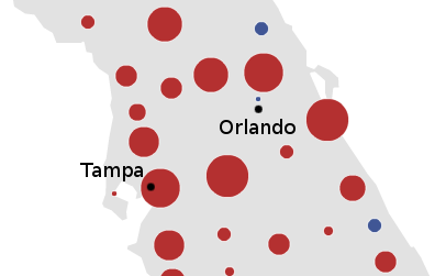
Here is the performance of a relatively weak Democrat, John Kerry, in the I-4 corridor:

John Kerry gets absolutely pummeled. There is a sea of red counties. This is the reason why John Kerry lost Florida.
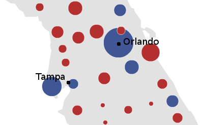
Here is the performance of a stronger Democrat, Barack Obama:

He does better. Obama’s probably winning the I-4 corridor, largely due to his landslide victory in Orlando – where he took 59% of the vote, the highest Democratic performance since 1944. Still, it’s a very very close thing (actually, Obama’s only leading by several thousand votes if one adds up all the counties pictured). Compared with how the Democrats did nationally, winning by 7.2%, that’s a very unimpressive result.
McCain and Obama essentially ran even in central Florida, or Florida’s “swing” region. They also ran even in Missouri, Indiana, and North Carolina. To say that the I-4 corridor is as conservative as North Carolina is an eye-opening statement. But the data backs it up.
There is hope for Democrats, nevertheless. The type of conservatism typified by central Florida seems like a softer, more suburban type of conservatism. Central Florida voters are probably more accepting of Democrats and willing to vote for them. Republicans won most counties in the I-4 corridor – but they did by 10 points, not by 40. Using an analogy earlier from this post, Central Florida Republicans are more akin to Phoenix Republicans than their northern Florida counterparts. While the I-4 corridor didn’t vote for Clinton in ’92, it did so in ’96. In contrast, the conservatism typified by northern Florida and the Deep South is deeply ingrained and rock-hard. Only a tidal wave can change voting patterns there.
Moreover, demographic change may shift central Florida leftward. This is especially evident in Orange County (Orlando) and Osceola County. In 1992, Orange County gave George H.W. Bush one of his largest margins in central Florida; he won it by double-digits. In 2008, it was Obama’s best-performing county in the region. The U.S. Census estimates that around 40% of the population is black or Latino, highly Democratic voting blocs. Rapid Puerto Rican immigration into Osceola County, too, has led to a nearly 30% voting shift since 1992, according to the Times.
For the moment, nevertheless, the I-4 corridor is roughly as conservative as North Carolina in terms of votes. To summarize so far: northern Florida, commonly considered the Republican base, is as red as the Deep South. Not parts of the Deep South; the Deep South as a whole. The I-4 corrider, which is called Florida’s “swing” region, swings blue just as much as Indiana, Missouri, and North Carolina did in 2008. Historically, it’s probably been closer to Missouri; to call central Florida as red as Indiana or North Carolina is probably an overstatement.
Miami, as we shall see, is about as liberal as Dallas and Sacamento.
–Inoljt, http://thepolitikalblog.wordpr…