This diary was inspired by a comment from Nichlemn on markhanna’s recent diary which read, “[Other blogs] are for people who want to know who’s likely to win the next big election. SSP is for people who want to know who’s going to win the Democratic primary in UT-03 or draw a Republican gerrymander of MA.” Well, I’ll leave the Utah forecasting to someone else, but here is a redistricted map of the Bay State with the GOP running things!
Note: If this is against the rules–a Republican gerrymander on a Democratic site–please take it down, and I apologize. If it’s OK, let me know if you like it, because I have one for New York too!
A few things to note before we get into it:
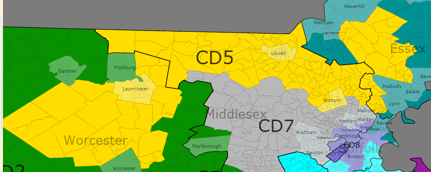
1. Massachusetts, unfortunately, will be losing a seat after the Census. I guess the weather is better elsewhere. This map is for nine congressional seats.
2. The current 10-seat map is a very ugly and somewhat unnecessary gerrymander. (Please feel free to venture a guess as to what Frank’s or McGovern’s district looks like now.) Democrats control all 10 districts, but probably would anyway on a fairly-drawn map. However, the current plan is designed to favor Boston-area politicians, as 6 of the 10 members of the current delegation live within 5 miles of the Hub. As a result, Middlesex County is split between 7 districts, Norfolk County has four spaghetti strands, and there is no Member from the southeastern part of the state. I tried to improve on the geographic balance somewhat.
3. Getting even one or two GOP seats was tough! The thing with Massachusetts is that Democratic strength is so evenly spread out across the state. President Obama won 302 of the 351 cities and towns, and won no less than 43% in any community statewide. To further complicate things, most of the 49 communities John McCain did win are inconveniently located near Democratic bastions like Worcester, Lowell, and Taunton. Thus, this “Republican gerrymander” is made up of 7 safe Dem seats, 1 tilt R seat, and 1 likely/safe R seat. I doubt there is any other state where a gerrymander means you have a shot at 2 of 9 seats!
4. Everything is based of presidential results. While Scott Brown put up nice numbers, there is no reason to think this will change long-term voting patterns. There is no partisan data yet for MA, so I used town-by-town results to estimate the leanings.
And here we go!
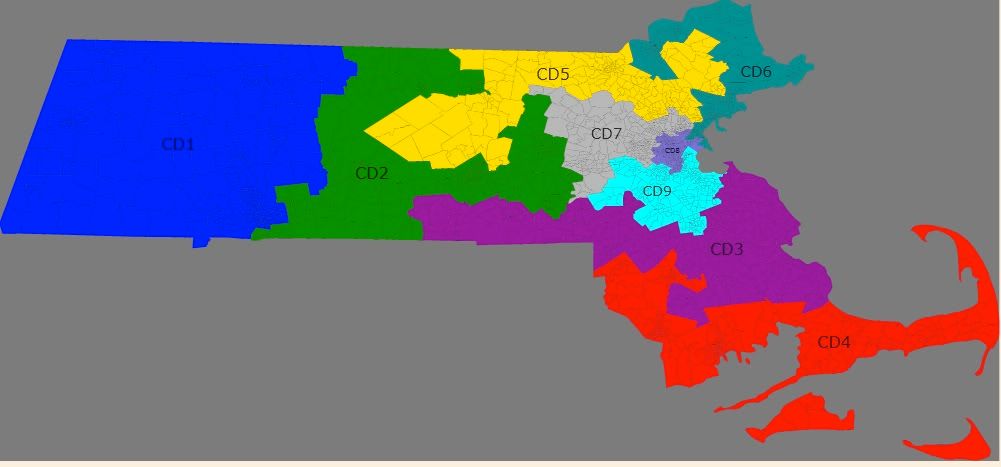
MA-01 John Olver (D) vs. Richard Neal (D)
Partisan Data: D+15-20. Obama probably got ~70% here.
Finally, Western Massachusetts has its own district, and it’s a mix of bohemian rural towns and the industrial city of Springfield. Politically and culturally, this area has much more in common with Vermont than with the rest of Massachusetts. Home to Amherst, Williams, Smith, and UMass among others, this district is both very Democratic and very liberal (not always the case here.) I drew this to be a fair fight between veterans Olver and Neal, with about equal amounts of population from their current districts. My guess is that Olver would retire in this situation.
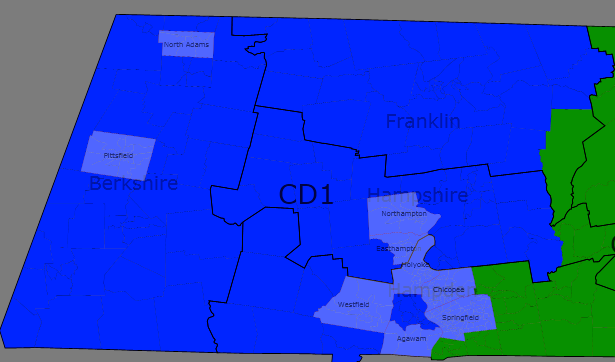
MA-02 Jim McGovern (D)
Partisan Data: PVI around D+10. Obama scored in the low 60’s here.
An ugly yet efficient Democratic vote sink in Central Massachusetts, this is mostly new territory for McGovern but he won’t be complaining. His current district, which went strongly for Brown, is more moderate than its PVI suggests, and as one of the most liberal members of the house McGovern could be vulnerable there if not for his immense personal popularity. He retains his home base in Worcester and adds friendly territory to the north, east, and west. This district will be a pain to represent, as Fitchburg, Longmeadow, and Hopkinton have little in common.
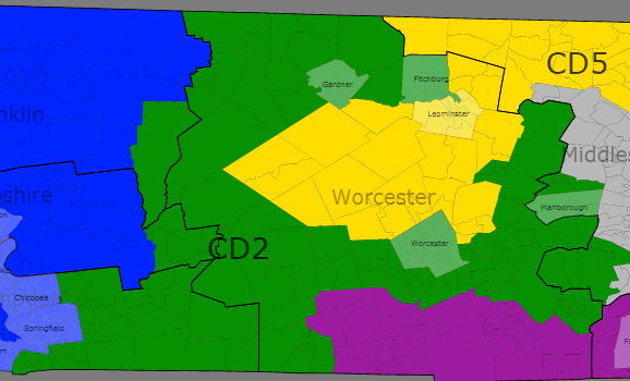
MA-03 (purple) and MA-04 (red) OPEN
MA-03 Partisan Data: R+6. McCain 52, Obama 47
Here’s the first, and better, of the two opportunities for the GOP on this map. The district is made up mostly of exurbs of Boston, Providence, and Worcester, combined with the wealthy South Shore (Plymouth County.) In fact, it’s the only Massachusetts district without a significant urban area. I-495 runs right through the heart of this district, and a Republican from the Franklin area like St. Sen Richard Ross would be favored in this race. If Joe Malone wins the current MA-10 this year, this would be his district. Scott Brown also lives here and probably approached 70% of the vote in the January Senate race.
MA-04 Partisan Data: D+7 or so. Obama was around 60% here.
I know my map will never be drawn, but seriously, this district must be. As it stands now, men from Worcester, Newton, and Quincy represent the South Coast, Cape, and Islands, which are a world away from those other places. This plan unites the three, whose economies are heavily depending on fishing, and in the case of the South Coast, shipping. Politically, the Inner Cape is conservative, the Outer Cape and Islands are very liberal, and the South Coast is dominated by the Democratic cities of New Bedford and Fall River. If Rob O’Leary (D) wins the MA-10 race this year, he will be a perfect fit for this district.
MA-05 Niki Tsongas (D)
Partisan Data: PVI R+3 McCain 49, Obama 49
Niki Tsongas is the weakest member of the current delegation, vastly underperforming in her only contsted election so far, and I made every attempt to draw her into a McCain district. Well I did–by about 250 votes. This plan chops off the liberal southern half of Tsongas’ current district and replaces it with Worcester’s northern suburbs and some Boston exurbs from Essex County. Most of the population comes from the conservative (by MA standards!) Merrimack Valley, which keyed Brown’s win, but geography forced me to include the liberal mill cities of Lowell and Leominster. Thus, Tsongas or another Dem wll have a shot, but the GOP should have a slight edge in a an even year.
MA-06 John Tierney (D)
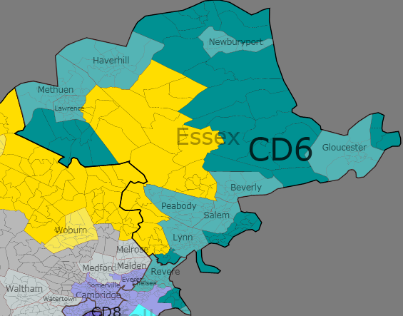
Partisan Data: D+10ish. Obama probably cracked 60.
This is what remains of fast-growing Essex County after the conservative towns were given to MA-05 combined with the blue-collar cities of Revere, Chelsea and Winthrop in Suffolk County. The industrial and very Democratic city of Lawrence, which I had to keep out of Tsongas’ hands, is responsible for the ugly arm in the northwest. Tierney will cruise here.
Metro Boston Map
MA-07 Ed Markey (D) vs. Barney Frank (D)
Partisan Data: D+15 at a minimum. Obama would have been in the mid to upper 60’s.
Well, I couldn’t squeeze any more than two gettable districts for the GOP here, so the obvious consolation prize was throwing two of the most senior and powerful Democrats in Congress into the same district! But fear not, Dems: there’s a solution here. Markey has considered Senate runs before and may run against Brown in 2012, giving Frank a clear field. If Markey stays in the House, he’ll be geographically favored, and Frank can move to the Cape and run in the new MA-04 since he already represents a good chunk of the South Coast.
Politics aside, this Middlesex County district makes good sense. These are the primary western suburbs of Boston (MetroWest, as they are called), and are for the most part very wealthy and very liberal. Boston College, Tufts, and Brandeis are all in this district.
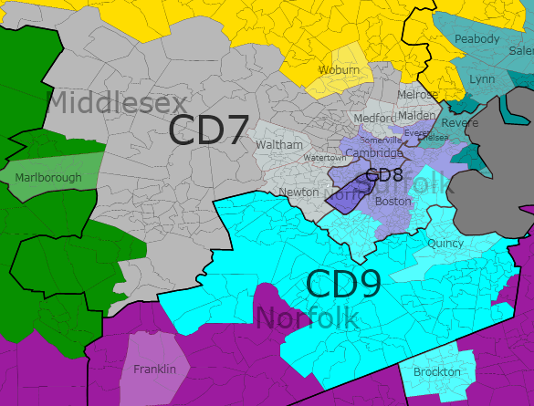
MA-08 Mike Capuano (D)
Partisan Data: D+32 or so, Obama won about 85%.
One of the most Democratic districts in the country, there’s little change here. Latte-liberal Cambridge and Brookline and blue collar Everett and Somerville combine with the majority of Boston to keep Capuano super-safe. I tried to put the most liberal parts of the Hub here–Beacon Hill, Back Bay, JP, Roxbury, Mattapan, and the South End are all included, as are Harvard, MIT, BU, Northeastern, and dozens of others. It’s 55% white, but MA has actually been losing minority population so I don’t think we’re in VRA trouble.
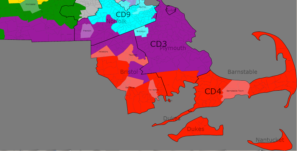
MA-09 Stephen Lynch (D)
Partisan Data: D+7. Obama was in the high 50’s.
Our final district belongs to the most moderate member of the current delegation, Stephen Lynch. The new district is very similar to his old one, combining most of suburban Norfolk County with the less liberal parts of Boston–Southie, West Roxbury, Hyde Park, and the white parts of Dorchester. The industrial town of Brockton is tacked on to the south to keep it away from the new MA-03. Scott Brown won here by more than expected, and this was one of those places where Obama underperformed Kerry. Nevertheless, it’s safe for Lynch until further notice.
And there you have it! McGovern and Tierney are the clearest Democratic winners, Tsongas and Frank are both losers, and Neal and Olver must slug it out in the west. The GOP has two opportunities now and may or may not have a third by 2020 depending on long-term trends in Lynch’s district.
Crazy that even with a GOP gerrymander, all you can do is a toss-up and a slight GOP leaning district in MA.
Definitely do New York. I’d love to see what you can come up with.
I’ve seen some ridiculous just-for-fun GOP gerrymanders posted by Democrats on here, and in some states (not MA, but still) a GOP gerrymander is just facing reality. 🙂
Anyway, this is a pretty cool map. Several minor quibbles: It’s Stephen Lynch (like the comedian), and BC and Tufts are actually split between your 7th and 8th. Not sure which district has the majority of either campus, but as they’re both Safe D I doubt it matters.
However, other than that, awesome work.
This is what the huge backlog of redistricting diaries I haven’t gotten around to posting in a timely manner SHOULD look like. (I think I promised someone a map of Indiana about a year ago…)
It’s also why I originally thought I’d only do states that I knew well. You get better results that way. That said, despite having spent much of my life in Berkshire County (plus a few months too many in Boston that probably drove me from MA for good), your knowledge of the state is better than mine. This is one of the better “random diary” redistricting maps I’ve seen, and I’ve been a lurker on this site since 2006.
I’d actually kind of like to see my home state of Maryland, where I suspect you could get to four Republican seats without it looking too ridiculous.
Not going for three though?
That MA-09 isn’t going Republican. Yeah, you’ve got some Reagan Democrat-type areas in there, but you’ve also got diversifying parts of Boston, liberal Metrowest towns, and both Brockton and Randolph.
Surprised you’d give up on the North Shore, with several towns that backed not only Brown, but McCain and even Bush the Younger before him, like that.
Trading Everett for Chelsea would probably be enough to accomplish this.
I have no idea whether or not the VRA requires this or not. The district is currently around 49% non-hispanic white.
Come to think of it, I also drew a SEMass district. It’d be perfect for O’Leary, as you state (not so much for Keating, though if he’s going to pretend to be a Cape Cod resident, he might as well go full hog) and, from a Dem perspective, Malone/Perry would have a tough time winning a district where Fall River/New Bedford dominated things.
If the map really was a Boston conspiracy, though, one of the WMass guys would have been pushed out last time; another reason the shapes are so weird is that there aren’t enough people in the west for 2 CDs unless Worcester is in one of them. It’s probably a matter of not wanting incumbents to have to face each other unless there is no alternative.
On getting what I think would be two lean-GOP districts, especially the third, but also the fifth, which is already getting more conservative in its present form and supported Brown by a huge margin. I have roots in the Merrimack Valley and it really is pretty culturally conservative by northeast standards. Many ethnic Catholics who still vote Democrat out of old loyalties.
This map seems to be more sensible, if anything, than the current one. Of course the Dems in power just want to consolidate their power and prevent any seat from having a Republican, and they can because the Dem strength is evenly distributed as you said. Massachusetts will probably slowly be more willing to elect Republicans, and I think the Scott Brown election in some part was a reaction to almost all of their representatives being far-left, 0% ACU Democrats, even the ones from moderate districts (Tsongas). Maybe it’s sort of like Utah but in the opposite way. Strongly Dem but maybe a tiny bit less so as we go forward.
If a gerrymander doesn’t have a district that looks like the flying spaghetti monster then I am a sad panda.
Touched by his noodly appendage………
Seriously, though, the main goal of the Mass. redistricting in 2012 has to be getting rid of Lynch.
Id like to see NY and others too.