This is the first part of two posts analyzing in detail the 1928 presidential election.
The second post can be found here.
The Context
In a previous post, part of a series analyzing the Democratic Party during the 1920s, I spoke of how the 1928 presidential election constituted a realigning election.
The 1928 presidential election marked the beginning of a great shift in American politics. It was when the Democratic Party started changing from a minority and fundamentally conservative organization into the party that would nominate Senator Barack Obama for president.
In 1928, the Democratic Party nominated Governor Al Smith of New York. Mr. Smith was nominated as a Catholic Irish-American New Yorker who directly represented Democratic-voting white ethnics. Mr. Smith’s Catholicism, however, constituted an affront to Democratic-voting white Southerners, who at the time were the most important part of the party’s base.
The 1928 presidential election thus saw a mass movement of white Southerners away from the Democrats, corresponding with a mass movement of white ethnics towards the Democrats. This was the beginning of the great realignment of the South to the Republican Party and the Northeast to the Democratic Party.
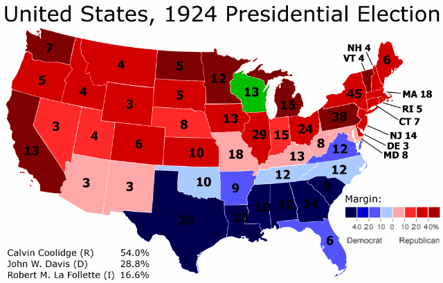
Several maps illustrate this point succinctly. Here is the 1924 presidential election:
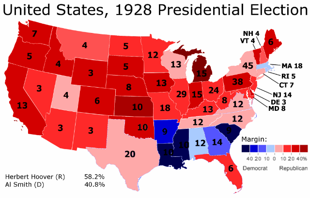
Here is the 1928 presidential election:
As one can tell, there is quite a bit of change from the one presidential election to the next. Democratic strength in the Solid South weakens considerably, while the Republican Midwest and Northeast become much less red.
However, it is somewhat difficult to go further into detail just by comparing the two maps. One can sense that a lot is changing, and that certain regions of the country are moving in diametrically opposed directions. But it is all rather vague.
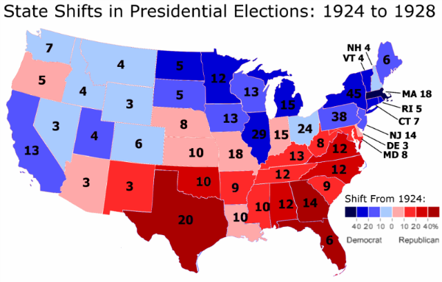
I therefore decided, out of curiosity, to create an actual map of the shift from 1924 to 1928. Here it is:
This is quite the interesting map. One can see the outlines of the current Democratic electoral map here. In some cases the correlation is quite tight. For instance, Indiana is the only state in the Midwest to vote more Republican in 1928 – and what do you know, today Indiana votes the most Republican out of all the states in that region.
In general the relationship is very strong in the eastern half of the country. The only “wrong” states are today’s Democratic strongholds of Maryland and Delaware. Also, the degree of shift does not perfectly correlate to Republican strength in some of the Southern states. But these are small details; in the East, states that moved Democratic in 1928 vote Democratic today, while states that moved Republican in 1928 vote Republican today.
West of Minnesota, however, the relationship breaks down. In more than a third of the states in the West, the way they shifted in 1928 is opposite of how they vote today. The most obvious outlier is Utah, today a rock-solid Republican stronghold that moved sharply Democratic in 1928.
There are two other very interesting and strange things that are happening in this map. They will be the subject of the next post.
–Inoljt


LaFollette got 16% in 1924, so comparisons are hard to draw.
from being the party of William Jennings Bryan and the abhorrent Ben “Pitchfork” Tillman to the party of Kennedy, Obama, and Clinton.