This is just a quick diary playing around the new version of Dave’s App and the new 2010 Census data for Virginia.
My first interest in playing with the new Census data was to figure out if two African-American-majority districts are possible, as most recent estimates have indicated. They are:
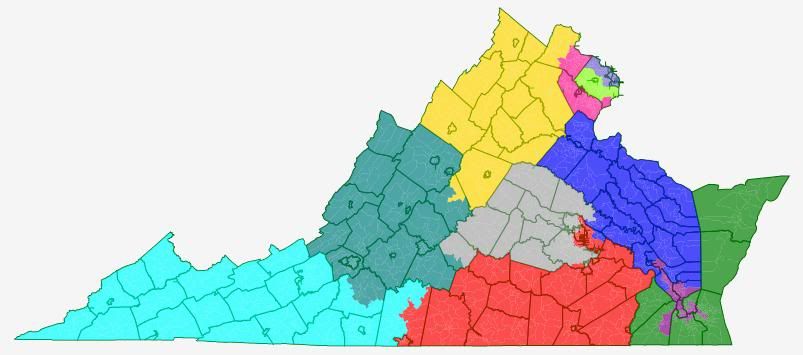
Here are the stats for those districts:
As you can see, it was just possible to make those two districts majority African American.
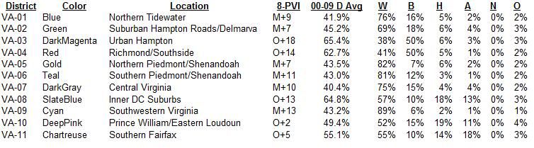
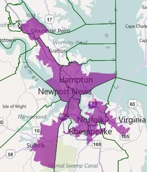
Here are close-ups of those two districts:
I found NoVA interesting too. In my ACS version of this map, which I don’t think I ever posted, VA-08 and VA-11 both fit entirely within the confines of Fairfax County and the closer-in localities, with a small amount of population left over. This ended up being true in the Census data as well.
What was different was VA-10. The ACS version took up the remainder of Fairfax County, along with all of Prince William, Loudoun, Manassas, and Manassas Park, and then also needed to go into Fauquier. The Census version not only doesn’t go into Fauquier, it takes in only about half of Loudoun (geographically.)
I also thought it was interesting that of the three NoVa districts, it was actually the exurban Prince William-Loudoun hybrid that was closest to being majority-minority.
Here’s a map of a true majority-minority district in NoVa — which doesn’t go into either Arlington or Alexandria(!):
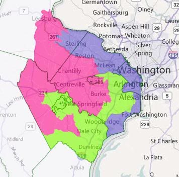
The lime green district has a VRA breakdown of
41 white/18 black/25 hispanic/12 asian/0 native/4 other
The other two districts are 60% white. Obama won all three districts, even with the Loudoun County bug.
Here’s a map with two majority-minority districts:
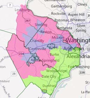
VA-08 (blue) is 46/10/21/18/0/3. VA-11 (green) is 48/18/19/11/0/4. Pink is 69% white, with Asians as the next largest group at 12%. Obama won all three of these districts as well — interestingly, this is actual a better configuration for him. He won the pink district by about three points more in the 2 majority-minority configuration than in the single. This is primarily because much of Arlington ended up in the pink district.
Other configurations are certainly possible. I suspect, although I haven’t been able to construct it yet, that a majority-minority district where Asians are the second largest group after whites is possible. So far, the best I’ve done puts Hispanics five points ahead of Asians.
If you don’t mind, I’m going to yoink those two districts out for a planned 6-5 solid D map.
That is a really nice map, kudos to you. Dumping inner city Richmond, Newport News, Hampton and Norfolk into one district was a blatant dump of African-American voters into one district. They aren’t even communities of interest right next to each other. Not that I either blame the VA GOP for doing this but it would be nice if Senate Dems would be able to hold the line on this though I am skeptical. I’m sensing that the VA GOP is going to wait until after the 2011 legislative elections to draw the Congressional lines in hope that they can take back the Senate which isn’t only a 22-18 Democratic advantage with only 2 seats flipping needed to flip control.
look a lot like the districts I drew in this diary attempting to do just that. The difference is, it was much easier to draw two majority-minority districts with the new census estimates showing larger than expected minority population. Very interesting.
its fascinating.
VA is one of those 9 states, of note, that have split political control. There is a huge amount of uncertainty in this state’s map. There is narrow D control of state senate while the house and Gov are securely under GOP control.
I think predicting redistricting is very hard in VA.
I personally think we will see a standpat map in VA. It might look a lot like protect all incumbents for the D’s but leave a couple of GOP seats somewhat competitive.
That’s just my guess. I think incumbents will push legislators to avoid Federal court.
If either seat in NOVA is currently minority majority I think that status is preserved but I don’t look for a seat like the one in this map above to be created by the federal courts. I have made my views on VRA clear so I don’t want to beat a dead horse.
So there is enough incentive to settle on a map in early summer.