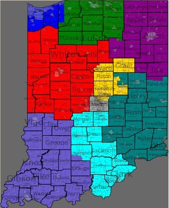
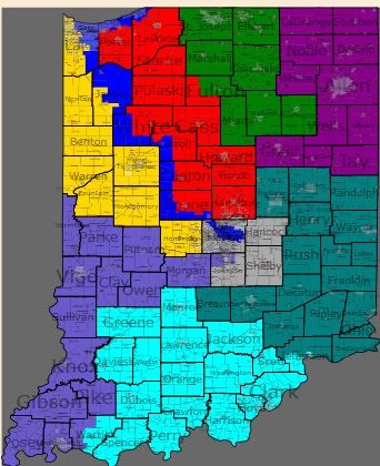
I tried my hand at redistricting Indiana, since it’s census data was out. I have two maps I created, one is a fair map (at least what the Republican legislature would call fair) and the other is a gerrymander. It’s been said the Gov. Daniels doesn’t want to go too crazy with the map, so we can’t be too sure exactly how aggressive the GOP will get.
IN-2 is modified enough where a Republican can win it and it didn’t take much to achieve that. Joe Donnelly would have probably lost this district in 2010. IN-5 changes a bit and gets more compact, but it’s still solid Republican. IN-9 should be safer GOP by taking on Lawrence and Morgan Counties, while all other districts stay close to the same. Now, onto the gerrymander.
I mistakenly reversed the colors for the 4th and 5th districts, so I thought I’d point that out first. What I have done here is throw Visclosky and Carson together into a vote sink that sucks up the most strongly Democratic voting areas. To make this possible, I had to give Hammond to Rokita, but it wouldn’t pose much of a problem for him, as there is plenty of strong Republican territory still attached. Burton picks up portions of LaPorte and Porter Counties, but still remains safe. IN-7 should have a Republican PVI now, as it takes in out portions of the county and some surrounding counties. IN-6 had minimal changes, while IN-8 and IN-9 are slightly better for Republicans.
I have doubts the GOP will become so aggressive as far as IN-1 goes, but I would not be surprised if something like this were at least attempted by the legislature. I like coming up with egregious gerrymanders, so it was drawn mostly for fun, but it should be kept in mind.


The second map is tempting, but would get them in trouble for doing a racial gerrymander.
beyond hope that Baron Hill reconsiders and runs again.
map #1. That could be a likely GOP combon.
I thought perhaps that the GOP might retain more of the Cincy suburbs in CD9 but lose Monroe county.
I think you hit the nail on the head, however, as Monroe will go with Morgan & Johnson county. Sorta like with one you get eggroll.
Under this arrangement on the menu Monroe, Johnson & Morgan can go South(lik you have it) or North to CD4 or East to CD6. It really does not matter in my opinion which way it goes. I might prefer CD4 but CD9 would work.
but probably wont happen. I think the GOP is going to be content to seriously weaken Donnelly, try to buff up the two districts they won last year, and generally leave Visclosky and Carson alone, or even pack their districts more.
But if if it’s like most areas, I’m guessing the southern, more suburban areas are probably almost as Republican as the rural areas across the county line. Why not split Lake and Porter (geographically speaking), roughly in half? This would allow you to include South Bend in IN-1, which would mean primary Viclosky, and ensure IN-2 would stay safely Republican.
I think your Map #2 is too over-the-top gerrymandered (Avon and East Chicago are not going to be put in the same district!), but Map #1 is too timid.
I do think they will go for some form of a North-South solution to IN-01 and IN-02, that will be more aggressive than what you’re proposing here — Whether it runs from the IL border through Michigan City or all the way to South Bend, either way it mades an uber-Democratic 1st district, and a 2nd district no Democrat can probably win.
I think that IN-07, the Indianapolis-based district, will be made more of a Democratic sink. I think what they might do is cut off the southern third or so of Marion County, and remove that from IN-07 — this is the part of Indianapolis that is literally 95% white, and very conservative. Andre Carson would in no way be sad to see Beech Grove removed from his district!
If the GOP wants to be really sneaky, create a district with this part of Indy, Johnson, Hendricks, and Morgan County — and then throw Monroe County (Bloomington) into it. It would be a safe GOP district, and would remove their “What to do with Bloomington” question from the two southern Indiana districts.
Here’s what I came up with for Indiana a few days ago. IN1 and IN2 are almost identical to yours. IN2 is much more red although Donnelly could probably win it in a good year. I agree that he would have lost it in 2010. My map keeps the two southern districts fairly close to their current configurations at a cost of a much uglier IN5, that now goes to the Illinois border. I suspect the mapmakers won’t care what Burton thinks, though.