(MI, NC, IL) Redistricting Potpourri

This diary presents potential redistricting maps for Michigan, North Carolina, and Illinois. It also carries the ulterior motive of the following bleg:

I’ve started working on two related projects for Michigan for Dave’s App. I’m collating partisan data and renaming the voting districts by municipality name and precinct number. (Currently, Michigan’s voting districts are named using a 14 digit code.) I could use the following three forms of help:

1. I need a precinct map for the city of Detroit. This is looking ahead a bit, because Detroit is the final portion of the state I intend to work on, but it would really help. My Google-fu has failed me thus far.

2. In order to enable collaboration (see third form below), I need to figure out how to get the lines in my copy of vt26_d00.csv sorted by county and voting district number. The vt26_d00_data.csv file is already sorted like this, but its counterpart is somewhat helter-skelter. The solution that occured to me was to try sorting it using OpenOffice Calc (my only spreadsheet program), but that immediately lost leading zeroes, which breaks the CSV file. Any ideas out there?

3. Actual collaboration in collating and renaming. I’m currently going through the counties alphabetically. After two-ish weeks of sporadic effort, I just finished the H’s with Huron County. (On to Lansing’s Ingham County next!) That’s about 19% of the state population. Doing Flint’s Genessee County took most of the day yesterday, and I’m fairly frightened of Kent/Macomb/Oakland/Washtenaw/Wayne. Even if you’re just interested in helping with some of the smaller, easier counties, I’d be grateful. If you’re willing and interested, send me an email at my user name at gmail.com so that I can send you information about the conventions I’ve been using. Also, post a comment letting me know you emailed me — it’s a secondary email that I don’t otherwise check.

After the jump, you’ll see the following forms of actual content to assuage my conscience from this bleg:

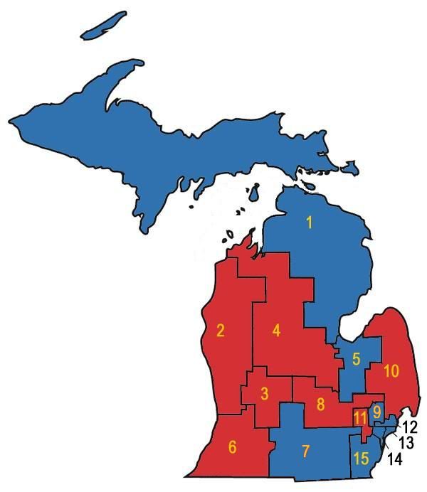
Michigan: what my partisan map progress looks like so far and a potential Republican gerrymander (an abgin-esque atrocity by Michigan standards)

North Carolina: a Republican map that packs five Democratic incumbents into two districts

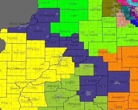
Illinois: an oxymoronic “good government” map of Illinois — I’m posting it mostly to show that two majority Hispanic districts in Chicago are easily created and to show off an particular idea for a reconfigured 17th district.

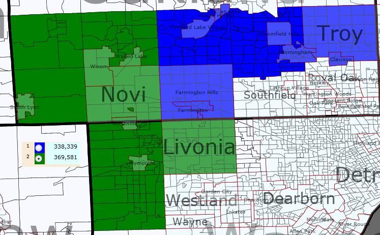
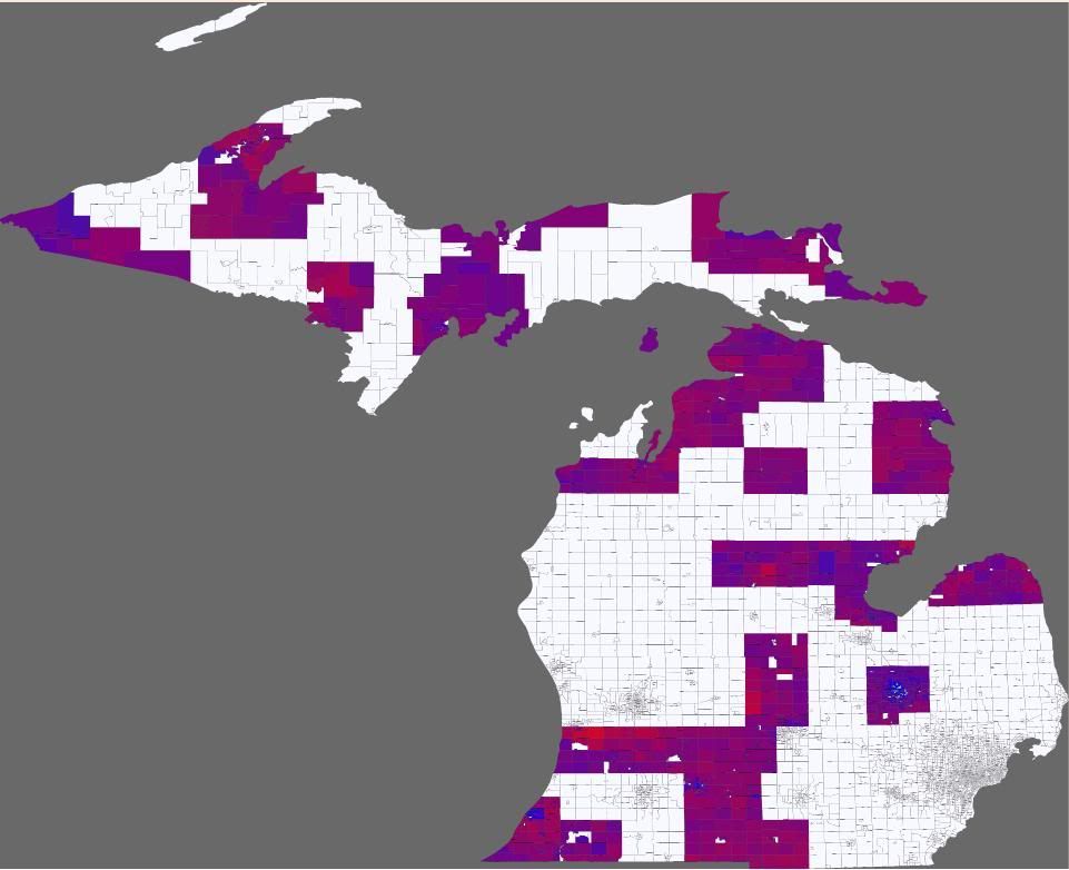
Michigan Partisan Progress So Far

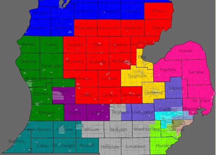
Michigan Republican Gerrymander

Michigan redistricting law heavily discourages county and municipality splitting. This map probably looks tame by most states’ standards, but it’s basically an abgin-esque “finding the limits” map by ours.


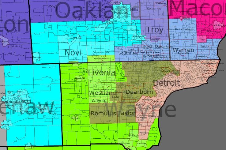
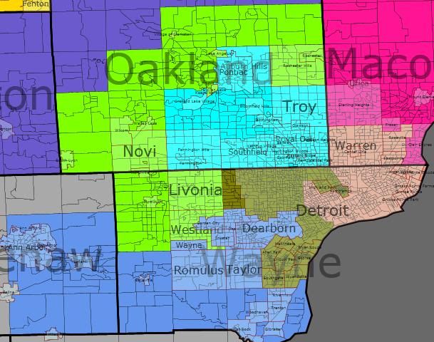
The Detroit-Ann Arbor-Flint CMSA

This map has its origins in a comment — I don’t recall which thread — that posited an I-75 district linking together Kildee and Peters. This is my attempt to make that district and show its consequences.

I started by painting in all of Genessee County (I really don’t think you can get away with having a district consisting of only portions of three different counties.) Then I painted in the bare minimum number of people to take in Saginaw City from Saginaw County — no GOP plan is going to saddle one of their representatives with Saginaw. Finally, I snaked down through Oakland County, taking heavily Democratic Pontiac and Peter’s home area of Bloomfield /Bloomfield Hills.  That, as it turns out, is a district. So I started working other districts around it.

End result: Peter’s 9th district has been eliminated by trisection. Its eastern third is now in Miller’s 10th, its central third is in Kildee’s 5th, its western third is in McCotter’s 11th.

I won’t dissect the districts in detail, but suffice it to say that I think this is a fairly successful Detroit-area map for the GOP. McCotter gets majorly shored-up (although he might at primary risk from an Oakland-based politican), Miller probably washes out in trading the Thumb for eastern Oakland, and Peters gets the short end of the reapportionment stick.

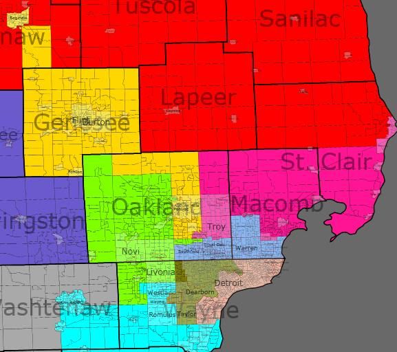
Taking a look statewide…

… there are some interesting repercussions, mostly favorable to the Republicans. Starting with one of the pieces of bad news, however, with the 5th and 10th sucked down into the Detroit area, the 4th is forced to cover the Thumb. Dave Camp becomes an incumbent in-name only, with only his home county of Midland and the western portion of Saginaw County overlapping between his current district and this one. I would guess that this district is at least as Republican as his current one, but I’m not entirely sure.

With the 4th swinging east, the 1st gets to pick up the Republican-leaning Traverse City area, mildly shoring up Benishek. The 2nd and 3rd also get pulled north by the 4th’s relocation. That, in turn, allows Upton to take in all of Republican Allegan County and Walberg to newly acquire heavily Republican Barry County — a significant upgrade for him that I’ve been otherwise unable to find. I’m genuinely unsure about how the changes to Roger’s 8th district pan out — he loses Republican northern Oakland, and gains some swingy territory in central Michigan along with fairly Republican (I think) Ionia County.

Summary: This map definitly eliminates a Democratic incumbent. I think it also shores up four Republican incumbents while severely inconveniencing another, with the effects on yet another being unknown.

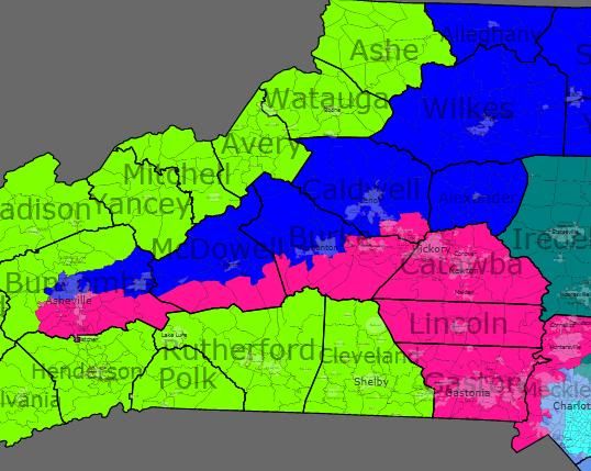
North Carolina Republican Gerrymander

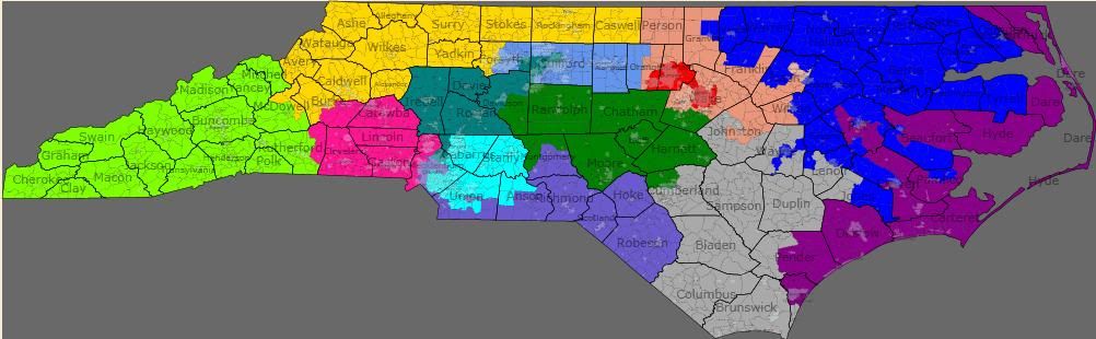
This map has its origins in SaoMagnifico’s recent Wyoming Rule diary on North Carolina. While composing a counter-suggestion to his proposed map, I discovered that there’s a significant African American population in and around Fayetteville. I’ve seen some insisting that this population could be linked with Raleigh’s to produce a new VRA-seat. My attempts at drawing that district while preserving the current 1st have failed, but it turned out to work well when linked with Charlotte’s African-American population instead.

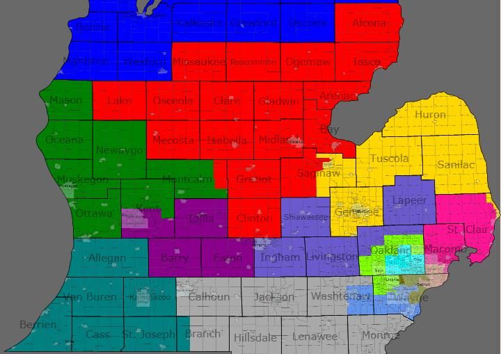
This is a 7-4-2 Republican/Democratic/swing map.

A quick run-through:

The 1st district (blue) stays more or less in place. VRA: 49% black, 44% white (is this kosher?). 2008: Obama 62%, McCain 37%.

The 2nd district (green) shifts substantially west. Still contains all of Ellmer’s (and Etheridge’s) Harnett County. 2008: McCain 56%, Obama 43%.

The 3rd district (purple) now hugs the coast all the way down to (and including) Wilmington. Incumbent Jones is (barely) drawn outside the lines, but I’ve been told he’s outside the lines already. 2008: McCain 57%, Obama 42%.

The 4th district (red) packs Price and Miller into one uber-Democratic (majority-white) district. 2008: Obama 73%, McCain 26%.

The 5th district (yellow) continues to hug the northwest corner of the state. Foxx now lives in her district. 2008: McCain 60%, Obama 38%.

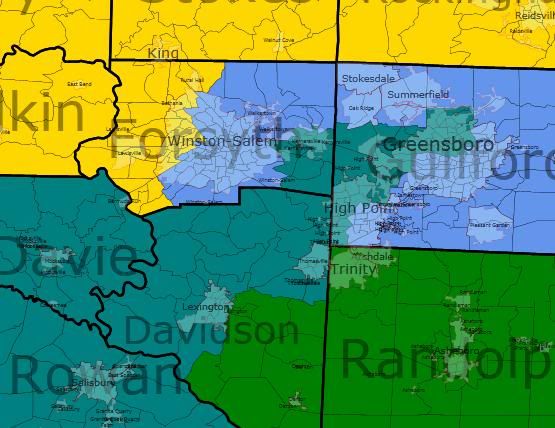
The 6th district (teal) shifts west. This is kind of like a bizzaro-12th, covering broadly similar territory between Charlotte and Greensboro, but with the intention of being a Republican district instead of an African-American gerrymander. Coble still lives here, I think. If not, he’s close. 2008: McCain 56%, Obama 43%.

The 7th district (grey) is still in the southeast corner of the state, reaching north into the eastern parts of the old 2nd — but it’s been reconfigured to exclude incumbent McIntyre. 2008: McCain 56%, Obama 43%.

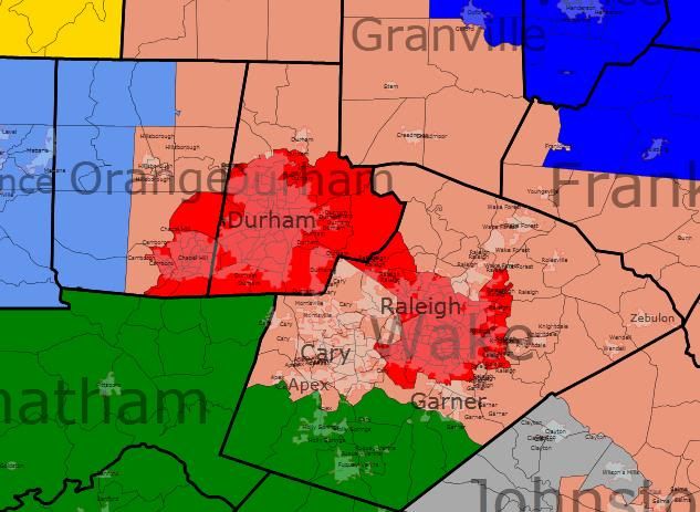
The 8th district (slate blue) is the center-piece of this plan. It strings together all three of Watt, Kissell, and McIntyre into a minority-majority district. VRA: 41% black, 35% white, 13% Hispanic. 2008: Obama 66%, McCain 33%.

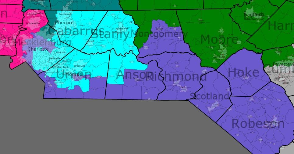
The 9th district (cyan) now lies exclusively east of Charlotte. So far as I know, Myrick still lives in the district. 2008: McCain 55%, Obama 44%.

The 10th district (magenta) pulls in closer to Charlotte. 2008: McCain 59%, Obama 40%.

The 11th district (lime) stays in place. 2008: McCain 52%, Obama 46%.

The 12th district (cornflower) is a (majority white) Democratic new open seat in the Triad. Effectively, the Republicans get rid of both of McIntyre and Kissell and replace them with a Triad-area Democrat. 2008: Obama 60%, McCain 38%.

The 13th district (salmon) is a swing(!) district surrounding the Triangle. 2008: McCain 50%, Obama 49%.

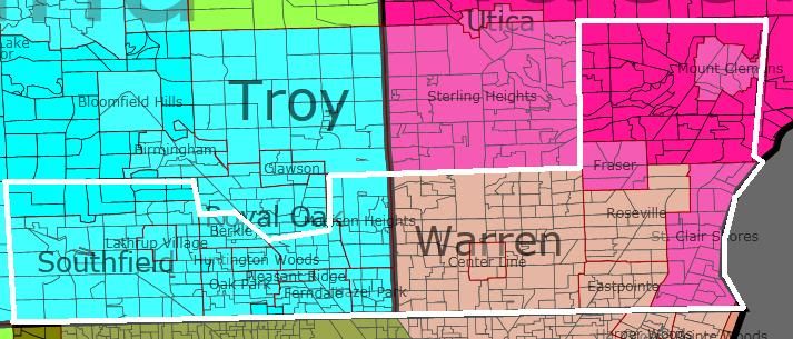
If not screwing with Shuler is something you can’t see the Republicans doing, here’s an area map for the changes necessary:

(Please ignore the 5th changing colors.]

New stats

5th:  56 Mc / 42 Ob

10th: 57 Mc / 42 Ob

11th: 58 Mc / 42 Ob

Illinois Good-Government Redistricting

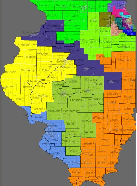
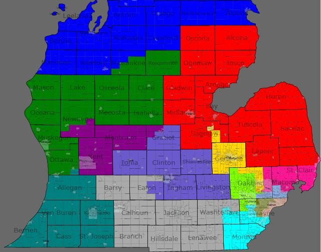
This map was drawn to avoid splitting counties and muncipalities — an idea I support in the abstract if not necessarily in practice. I won’t go into detail at all about it, because I don’t feel like I understand Illinois well enough. But I wanted to draw attention to two features to see what people think who do understand Illinois politics. (The 11th and 16th — both green — can be hard to distinguish. DeKalb, LaSalle, and points east are in the 11th.)

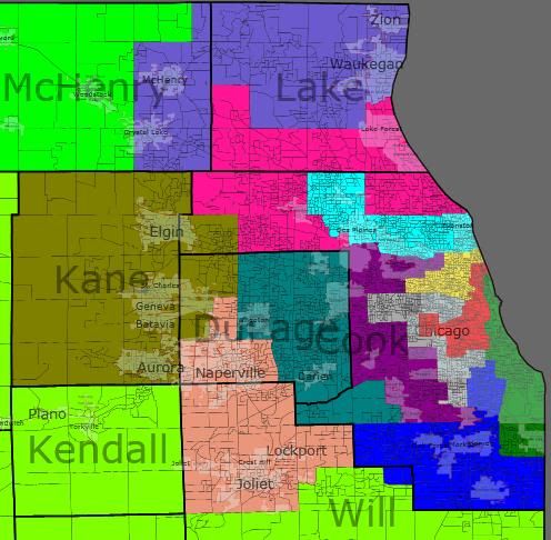
Feature one: Here’s the VRA statistics for most of the Cook County districts.

1st (blue) — white 39%, black 53%

2nd (green) — white 26%, black 58%, Hispanic 10%

3rd (purple) — white 75%, Hispanic 16%

4th (red) — white 25%, black 12%, Hispanic 59%

5th (yellow) — white 32%, Hispanic 51%

7th (grey) — white 29%, black 53%, Hispanic 16%

9th (cyan) — white 66%, Asian 13%, Hispanic 12%

Actual census numbers may change this, of course, but 2 VRA Hispanic district seem possible with a miminum of fuss.

Feature two: Note district 17 [dark blue] in the whole-state map above. It links together the Quad Cities, Bloomington-Normal, and Champaign-Urbana. Is this a workable Democratic district?

If not — I’ve gotten the impression that Bloomington-Normal is fairly Republican for a mid-sized city — how about this, which substitutes in Decatur?

Michigan Redistricting 2012: 9-5 GOP

Quick History

The Republicans controlled the redistricting process in 2000, shifting the map from a 9-7 Democratic advantage to a 9-6 Republican one. (Michigan lost a seat in reapportionment.) They did this by redistricting three seperate pairs of Democratic incumbents into the same districts, thereby creating two new open Republican seats elsewhere. Architect of this plan? None other than then-state-senator Thaddeus McCotter, who oh-so-thoughtfully created one of those new open districts around his home base.

The GOP plan had turned into a little bit of a dummymander, since by 2008 the Democrats had flipped two districts to get an 8-7 advantage. This week's election, however, has restored the Republican's 9-6 edge. The 1st and 9th districts are in opposite hands from the 2002 elections; all other districts are controlled by the same party that won them eight years ago. (Wikipedia’s version of the pre-Tuesday districts is above for reference.)

The Genesis of this Plan: Failed Attempts

One of my consolations on election night was the idea that even with control over redistricting again, the Republicans couldn't really make it any worse. At the time, it looked the the Democrats were going to be down to five districts: Dearborn-Ann Arbor, Flint-Saginaw, Southfield-Warren, and the two Detroit districts. That seemed like pretty much the rock bottom base of support for the Democrats in Michigan. But then Gary Peters pulled out a narrow victory, and I started to look to see whether the Republicans could get the Democrats down to five after all. Michigan is almost certainly losing another district, so let's see if it can be made a Democratic one.

Four of the six Democratic seats seemed pretty much untouchable. The VRA-protected Detroit-based 13th and 14th districts are, of course, ridiculously Democratic. Sander Levin's 12th district pulls together an only somewhat less-ridiculously-Democratic set of inner suburbs on Detroit's north side. And despite Dale Kildee's narrower-than-expected win on Tuesday, Flint is big enough to dominate pretty much any district you could conceivably put it in. That leaves Gary Peter's 9th district and John Dingell's 15th district as the remaining targets.

My first attempt actually took on John Dingell's district. Stretching from blue collar Dearborn to the university town of Ann Arbor, it was created as one of the three "pairing" districts, setting up then-Representive Lynn Rivers against Dean of the House Dingell. Dearborn was easy to move into John Conyer's 14th district. Ann Arbor has to end up in Democratic district, so I swung Gary Peter's 9th district around to pick it up. Thad McCotter's 11th then mostly gives up its claim on Oakland county to pick up the rest of the dismembered 15th.

The problem with this plan from a GOP perspective is what it does to McCotter. The distict is probably about 60% – 70% new to him, and it's not nearly as Republican as his old district. I haven't run the numbers, but just from eyeballing it, I would be surprised if this version of the 11th district didn't have a Democratic PVI.

My second attempt left Dingell's district more-or-less alone. (As pictured, all of Dingell's hometown of Dearborn ends up in Conyer's district, but this could possibly be played with.) Instead I merged McCotter's 11th district with Peter's 9th district. The resulting district has about half of its population come from each district. (Old Peters in blue; old McCotter in green.) It cuts out the most Democratic parts of each district (Wayne, Westland, and Garden City for the 11th; Pontiac, Auburn Hills, and Royal Oak for the 9th). Again, I haven't run the numbers for PVI; I suspect it's a Bush '04-Obama '08 district.

McCotter probably isn't the best candidate for an incumbent vs incumbent race, but this district — in isolation — would probably suit the state GOP fine.

The problem is what the rest of the state looks like.

Merging the 9th and 11th pulls Mike Roger's 8th district further east and north. This saddles the already swingy 7th district just won by Tim Walberg with heavily Democratic Lansing. The 7th, in turn, now donates Democratic-leaning Battle Creek to Fred Upton's already even-PVI 6th district.

The Solution

So if I couldn't dismantle Dingell's district without giving McCotter too much hostile territory, and if merging McCotter's district and Peter's district resulted in weaker districts for Walberg and Upton, then what?

I was stumped for about a day, when the answer occured to me: attack Sander Levin's 12th district instead.

By bringing the Detroit-based 13th district north across Eight Mile into Macomb county, I could merge the Oakland portion of the 12th district into the 9th. (The old 12th is roughly outlined in white.)

Brief District-by-District Rundown

I'm considering working through the data to get firm PVIs for the proposed districts. For now, you have eyeballing-it. I did refer to the 2004 and 2008 numbers while drafting; I just never actually ran the calculations.

1st District (Blue)

This district is newly captured by Republican Dan Benishek. In the 2000 redistricting, this district was pulled down the Lake Huron coast towards Bay City as part of the dismantling of then-Representative Jim Barcia's district (he got paired with Dale Kildee in the 5th). Without such concerns, I pulled it down the Lake Michigan shoreline instead. Adding the Traverse City area instead of the upper Saginaw Bay area should make this district just slightly more Republican. Traverse is also a better cultural fit for the district. (Note that everything not pictured in the north of the state is in this district.)

2nd District (Green)

This district is currently Michigan's most Republican district by PVI. I don't think my alterations will change that. It gives up its northern reaches to the new 1st and stretches inland, taking in Grand Rapids' northern suburbs and exurbs.

3rd District (Purple)

The primary Republican concern with this district is making sure it has enough suburban/exurban territory to overwhelm the Democratic urban core in Grand Rapids. It gives up some territory north of the city and gains Eaton county to the east. I think this will be slightly more Republican than the existing 3rd.

4th District (Red)

As currently configured, this district is something of a left-overs district, taking in the northern counties not in the Upper Peninsula-based 1st or the Lake-Michigan-coast-based 2nd. Under my proposal, it becomes a somewhat more focused Central Michigan district. Largest city (and hometown of incumbent David Camp) Midland is now in the center of the district instead of on its eastern fringe. It takes in all of Democratic Bay county, but I think the rest of the territory is Republican enough to handle it.

5th District (Yellow)

The proposed 5th district is much like its 1990s-district-plan predecessor, taking in much of the Thumb instead of Bay City. This is because eliminating Levin's 12th district pulled Candice Miller's 10th district out of the Thumb. Since it's over that way anyway, it runs a tendril down the St Clair River to relieve Miller of smallish-but-heavily-Democratic Port Huron.

6th District (Teal)

Not much changes for the 6th. It exchanges a few townships in Calhoun county for a few in Branch, and takes in the rest of Allegan county. That last change should make it slightly more Republican. Incumbent Fred Upton should remain fine here.

7th District (Grey)

This proposal's greatest weakness. Newly re-elected Tim Walberg has a district with a PVI of R+2. Getting Monroe county from the dismantled-by-reapportionment 15th in exchange for giving the new 3rd Eaton county is essentially a wash. I just don't think that there's much the Republicans can really do to shore this district up.

8th District (Slate Blue)

Still subsumes Lansing in a sea of Republican-heavy exurbs. This configuration gives up somewhat-Republican Clinton county to gain very-Republican Lapeer county, so Mike Rogers should be happy.

9th District (Cyan)

The new 9th is one of the center-pieces of the plan. It combines most of Gary Peter's current 9th with about half of Sander Levin's current 12th. If it came to a primary, I'm not sure what would happen. Where the current 9th was designed as a Republican seat that's just slipped away, this 9th would be a Democratic safe seat, anchored by Southfield, Royal Oak, and Pontiac.

10th District (Deep Pink)

Candice Miller's 10th is pulled south by the elimination of the old 12th. Losing most its rural hinterland, the new 10th is definitely more Democratic than the old one, but I don't think it's that much more. I think Miller should still be fine. In one of the rare set of calculations I did do, the portions of Macomb county not in the district (ie, in the new 13th) voted for 63% for Obama. The portions of Macomb in the district voted only 52% for Obama. That probably means that Bush won the new 10ths portion of the county in 2004 (here, we're back to no calculations.)

11th District (Lime Green)

In order to shore up McCotter, the district loses three of its inner surburbs and snakes around the north side of the new 9th to pick up some more heavily Republican territory. McCotter should put up much better numbers in this reconfigured district.

12th District (Cornflower Blue)

With the dismantling of the old 12th, I reused the district designation for the reinvention of Dingell's dismantled-by-reapportionment 15th. The new 12th loses Monroe county to pick up the southern portions of Downriver. I'm pretty sure this will push its PVI in an even-more Democratic direction, and Dingell (and/or his successors) should be safe here all decade.

13th District (Salmon?)

The other centerpiece of this plan. It takes in roughly similar portions of Detroit as its predecessor (along with the Grosse Pointes and Harper Woods.) Instead of stretching into Downriver, though, it crosses over into southern Macomb, snatching away the eastern half of Levin's district and saving Miller from having to take on the most Democratic parts of the county. VRA: 53% black, 42% white.

14th District (Olive Drab)

Conyers' new district takes in basically the same portions of Detroit as his old one. The primary difference are the addition of Redford township, the subtraction of any part of Dearborn, and the taking in of the northern half of the Downriver communities instead of the western half. VRA: 53% black, 34% white.

Pre-Conclusionary Note

I was originally concerned about whether this was too much county-splitting in the Detroit area, but it's actually less than currently exists. Currently, the tri-county Detroit metro area has the following configuration:

Wayne: 2 full districts (13th, 14th), 2 partial districts (11th, 15th)
Oakland: 1 full district (9th), 3 partial districts (8th, 11th, 12th)
Macomb: 2 partial districts (10th, 12th)
for 10 total county-fragments.

Under this new configuration, the tri-county Detroit metro area looks like this:

Wayne: 1 full district (14th), 3 partial districts (11th, 12th, 13th)
Oakland: 1 full district (9th), 2 partial districts (8th, 11th)
Macomb: 2 partial districts (10th, 13th)
for 9 total county-fragments.

Conclusion (TL;DR version)

By eliminating Levin's 12th district, I created four packed super-safe districts for the Democrats in the metro Detroit area, with one other safe Democratic district in the Flint-Saginaw area. Republican incumbents in the 1st, 3rd, 6th, and 11th districts are shored up. Republican incumbents in the 4th and 10th districts take minor hits. The Republican incumbent in the 2nd district needed no help; and the one in the 7th district is unhelpable. This plan would more or less lock in an 8 GOP – 5 Dem – 1 swing district pattern for the rest of the decade.