Maryland Redistricting, 8-0 Democrats

Recently, I saw quite a few redistricting maps, especially on Maryland. Here is my perspective. Instead of playing it safe, I went all out for an 8-0 map. The Democrats are in control and may try for a map like this. I know what you are thinking; it will be too difficult for Democrats to hold. I feel that I definitely made each Democrat’s district safe enough for them without throwing the VRA down the drain. The Democrats have large majorities in the State Legislature and if they retain the Governorship, this map is realistic. Enough chatter, here are the maps.

Central/eastern Maryland

West Maryland

Balitmore Area

District 1 Frank Kratovli (D) Blue

This district did go to the western shore to pick up population. Yet it picked up heavily Republican areas to keep out of the 2nd and 3rd districts. Now that Maryland is trending Democratic, adding Republican areas to other districts will be offset by Democratic margins. This left me free to slip in Democratic Annapolis into Kratovli’s district as well as a hunk of Prince George’s County. These changes raised the Black percentage from 11% to 24%. If a Republican could not win in a district that is 11% Black, watch him or her try to win in a district with Prince George’s County. Obama probably won 54% of the vote here. Demographics are 24% Black and 67% White. Status is Likely Democrat.

District 2 Dutch Ruppersburger (D) Green

His district is less gerrymandered but should be safe. I added some Republican areas of Baltimore and Harford Counties but I slipped in more of Baltimore City. These changes should make the district a little more Republican. Ruppersburger is a popular representative and should handle himself. Obama probably won 53%-54% of the vote here. Demographics are 22% Black and 69% White. Status is Safe/Likely Democrat.

District 3 John Sarbanes (D) Reddish Purple

Okay, I see the flaws. Yes, I know I took Sarbanes’s home out of the district. I had to because the district would be too convoluted if I kept it. I also know that Carroll County is heavily Republican. I included Democratic territory in Howard County which should offset Republican margins in Carroll County and more. For any more Republican areas, Baltimore City should offset their margins. Bartlett is Sarbanes is the son of longtime former Senator Paul Sarbanes (D). I do not see Sarbanes losing here anytime soon. Obama probably won 56% of the vote here. Demographics are 23% Black, 5% Asian and 65% White. Status is Safe/Likely Democrat.

District 4 Donna Edwards (D) Red

Her district extends into Republican Frederick County but Edwards should be content. The 4th district is VRA protected. Obama probably won 73% of the vote here. Demographics are 50% Black, 5% Asian, 9% Hispanic and 33% White. Status is Safe Democrat.

District 5 Steny Hoyer (D) Yellow

I took out northeastern Prince George’s County and pushed the district into Republican parts of Anne Arundel County. I only reduced the Black percentage by 1% and should probably get higher in the mid 2010’s because of Blacks moving into Prince George and Charles counties. Hoyer and is successor are safe. Obama probably won 60% of the vote here. Demographics are 29% Black and 62% White. Status is Safe Democrat.

District 6 Vacant Teal

No current representative lives here. Even though I put in some heavily Republican counties in western Maryland, I more than erased that margin by 60% of this district in heavily Democratic Montgomery County. I slipped in about 84,000 people in Prince George’s County just to ensure Democratic votes. That area gave Chris Van Hollen (D) his winning margin against Connie Morella (R) so it had to be in this district to ensure it will vote Democratic. Mark Shriver (D) might want to run in this district. It would be nice to have another Kennedy in Congress. Obama probably won 62% of the vote here. Demographics are 13% Black, 8% Asian, 14% Hispanic and 61% White. Status is Safe Democrat.

District 7 Elijah Cummings (D)

This district is BARELY protected the VRA. I tried to squeeze in as many Republican precincts as I could while keeping the Black percentage at 50% or above. This district used to go into Howard County but now takes in Republican suburbs in Baltimore, Carroll and Harford Counties. Since almost all the Baltimore precincts in the 7th voted around 90% for Obama, Cummings should be very safe. Obama probably won 67% of the vote here. Demographics are 50% Black and 43% White. Status is Safe Democrat.

District 8 Chris Van Hollen (D) vs. Roscoe Bartlett (R) Purple

Bartlett is 83 years old and about 63% of the 8th district is in Montgomery County, Van Hollen’s home base. Bartlett can campaign as a moderate but I see Montgomery County voters sticking with Van Hollen. With Bartlett out of the picture, Van Hollen should have an easy ride to reelection. Obama probably won 63% of the vote here. Demographics are 16% Black, 10% Asian, 13% Hispanic and 58% White. Status is Safe/Likely Democrat if Bartlett decides to run, Safe Democrat without Bartlett.

By what margin will Bob Shamansky win?

View Results

Loading ... Loading ...

Sensible Democratic Gerrymander of Illinois

The primary goals of any partisan redistricting should be to, first, protect endangered incumbents; and, secondly, maximize your seats without spreading your votes too thin to risk losing seats in a wave election.  Of the Republican gerrymanders after 2000, the Michigan map (where the GOP legislature aimed for a 9-6 split) held up much better than Pennsylvania.

My map aims for a 13-5 split in normal years, and possibly a 14-4 split.  It shores up Bean, Foster, and Halverson.  It throws Mark Kirk and Jan Schakowsky together in the new CD-1, which Schakowsky would easily prevail; and Peter Roskam and Judy Biggert together in the new CD-11, which is designed to elect a Republican.  It creates a new district centered in northern Chicago and the northwest Cook suburbs that are heavily trending Democratic.  Lastly, Downstate it puts Aaron Schock’s congressional career in jeopardy by combining Peoria with Decatur, Champlain, and Bloomington while trading Republican farm territory with Shimkus and Johnson.

Oh, and one more thing, I renumbered all the districts in logical order – it doesn’t make much sense to me that Jerry Costello’s current district is the #12 while #1-11 and the 13th are all in Chicago or Suburban Chicago.  

CD-1 (Schakowsky vs. Kirk) – Dem favored (57% white, 13% black, 7% asian, 19% hispanic)

Schakowksy’s currently configured #9, along with Quigley’s #5 are both too packed with Democrats.  Instead of having a PVI of D+20 and D+19 respectively, it is possible I believe to create four Chicago-North districts with only slightly lesser Dem PVIs.  This district extends along Lake Chicago from the lakefront wards of Chicago, north through Evanston, and New Trier Township, and then Lake County up to the Wisconsin border including Waukegan and Lake Zion.  

CD-2 (Bean) (69% white, 3% black, 12% asian, 13% hispanic)

By moving Schakowsky’s district north, I was able to draw Bean much closer into Chicago and into Chicago-trending suburbs.  Includes about 100k of Chicago itself, plus all of Niles, Northfield, and Palatine townships in Cook, plus more rural parts of Lake County.  Should be significantly more Democratic now.

CD-3 (Vacant) (69% white, 1% black, 11% asian, 16% hispanic

The third and fourth districts break up Quigley’s district into two parts and marry those parts with suburban townships in Cook and northern DuPage which are trending Democratic.  This district includes Elk Grove, Wheeling, and Maine townships, plus a fair amount of northern Chicago.  It should elect a Democrat.

CD-4 (Quigley) (65% white, 4% black, 9% asian, 19% hispanic)

Combines Democratic leaning northern DuPage townships (Bloomington and Addison, which both voted for John Kerry) and a small part of Milton with the rest of Quigley’s current district left over from drawing the third.

CD-5 (Davis) (52% black)

I decide to reorient how the Hispanic-majority district is hooked up to the Chicago lakefront instead of the Cook County border in order to dilute some suburban Republican votes.  Parts of Milton and all of York township in DuPage is added to the current district.

CD-6 (Gutierrez) (71% hispanic)

Little changes except how the two parts of the district are hooked up.  They now make a backwards C.  Still hideously gerrymandered.  By the time the next census comes around, it should become possible to create two separate Hispanic-majority districts in Chicago.

CD-7 (Lipinski) (63% white, 5% black, 1% asian, 28% hispanic)

Firmly anchored in Cook County and adds several left-over Hispanic precincts in the current #4 to bolster the Democratic nature of the district.  Possibly, Lipinski can be primaried if he still votes the way he does?

CD-8 (Rush) (52% black)

Extends out to Will County now to pick up Republican precincts in Lockport and Homer townships, same thing in Cook County (all of Lemont and Orland, most of Palos, and parts of Bremen and Worth, plus the south side of Chicago = a very good way to get rid of Republican precincts.

CD-9 (Jackson, Jr.) (52% black)

Adds parts of Will County (New Lenox, Manhattan, Frankfort and Green Garden townships) to currently existing district.  Exchanges parts of Monee Township with Halvorson to increase her district’s Democratic performance.

CD-10 (Halvorson) (58% white, 12% black, 3% asian, 23% hispanic)

Includes left-over parts of Will County not in CD-8 or 9 (which are significantly more Democratic) with Democratic-leaning Aurora and a tiny part of Kendall County to connect the two.  Should be safely Democratic now.

CD-11 (Roskam vs. Biggert) (71% white, 4% black, 9% asian, 13% hispanic)

Although it probably is possible to create several thin strands and eliminate every one of the remaining Chicago-area Republicans, it is safer I believe to leave one Republican-leaning district left.  The CD-11 is designed to be such a district.  It includes the left-over parts of DuPage not in the 4th or the 5th (Downers Grove, Lisle, Naperville, Winfield, Wayne, and parts of Milton (Wheaton) to include Roskam’s home), St. Charles and Dundee in Kane County, and Hanover and Barrington townships in Cook.

CD-12 (Foster) (74% white, 6% black, 2% asian, 14% hispanic)

All of LaSalle and DeKalb counties, most of Kane and Kendall, plus Rockford.  Should be safer for a Democrat now.

CD-13 (Manzullo)

One of three districts that pack Republican voters to ensure the election or reelection of Democrats in neighboring districts.  Rockford has been removed from the current district in exchange for all of McHenry and the far western rural townships of Lake.  District also now drops down to include Republican Lee and most of Bureau counties.

CD-14 (Hare)

Cleaned up the lines significantly by removing snake that went all the way to to Decatur.  District now includes all of Springfield and a few small rural counties to its north, along with some rural townships near Peoria.  Should still be safe for Hare or any generic Democrat with the dominance of Springfield and Rock Island.

CD-15 (Schock) (80% white, 10% black, 3% asian, 2% hispanic)

By straightening out the lines of Hare’s district, and with some clever trading of territory with Johnson, it opens the possibility to end Schock’s career before the Republicans groom him to take a leadership role.  Combines Peoria with Bloomington-Normal, Urbana-Champlain, and Decatur.  Furthermore, it does it in a way that doesn’t lead to serpentine appendages going everywhere.

CD-16 (Johnson)

The consequence of going after Schock means that Johnson gets quite possibly the most Republican district in Illinois.  Swaps Democratic-leaning Champlain and Urbana for Republican farm counties.

CD-17 (Shimkus)

The third and final district that packs Republicans.  It would have been nice to go after Shimkus too, and indeed, it would probably not be too difficult to draw Shimkus into a Madison-Springfield, Macoupin centered district that would be very tough for him to win re-election in.  But, many southern Illinois counties outside of Carbondale, Cairo, and Metro-East are trending very Republican and need to be placed somewhere.

CD-18 (Costello)

Adds Democratic-leaning Jersey, Calhoun, Macoupin, and most of Montgomery counties, Edwardsville of Madison country, to the currently Democratic areas of the district; swaps Republican-leaning Williamson, Franklin, and most of Union counties over to Shimkus’s district.

MO-Missouri Redistricting

Okay, so as my first diary, I’m sure this is overly long, but I wanted to add a lot of data and analysis as I could because I am relentlessly geeky.

So read on, if you dare…

Shout-out: Dave’s Redistricting App.

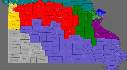
Missouri Congressional districts Post-2010 Census

With Missouri most likely dropping a seat and with the redistricting authority evenly split between the Democratic Governor and Republican Legislature, incumbency protection and relatively even numbers of safe and swing districts should be considered priorities. Plus, with the political battles likely to be intense enough to be settled by an independent-ish panel, I figured that drawing geographically-sensical boundaries would also be important.

Therefore, I tried to keep each county in the same district (which I did successfully, barring the expected biggies–Kansas City’s Jackson and St. Louis city and county). This was done as a proxy for the “communities of interest” standard that seems to crop up when redistricting time rolls around, but I ain’t a lawyer and don’t know about no redistrictin’.  

An added bonus of this map is that each area is contiguous and geographically-sensible. Finally, in terms of population, each of the 8 districts clocks in around 739,000 using the awesome Dave App’s “Use New Pop Est” feature. The biggest variance is less than 5,000 + or – and I figure some changes from the estimate are to be expected, so some tussling around the edges should be expected. The counties of Gasconade, Crawford, Phelps, Dent, Iron, St. Francois, Montgomery and St. Clair could all be shifted between at least 3 Congressional districts to equalize populations and still be a part of pretty sensible, contiguous districts. So what I’m trying for is a good working template for starting negotiations.

Relevant recent races:

Governor – 2008 — Democrat Jay Nixon vs. Republican Kenny Hulshof 58.4-39.5

Longtime Attorney General Jay Nixon stomped the lackluster Hulshof (after Sarah Steelman weakened him severely in the primary). I use this as a sort of shorthand for what a reasonably strong Democrat could potentially do. (although some Congressmen like Ike Skelton defy the odds even further once they’re entrenched incumbents). Basically, a solid, local but new-to-a-seat Democrat could outpoll Nixon by a few points, perhaps, but not much more.

President – 2008 — Democrat Barack Obama vs. Republican John McCain 50-50

Missouri’s bellweather status ended when McCain took a 4,000 vote victory over Obama out of almost 3 million ballots cast (ftr, national average was 53-47-ish). It’s an interesting shorthand for outsiders, but its variance from the Nixon numbers is an important insight into the actual voters of a county.

With that, here we go….
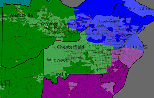
St. Louis Close-Up

———–

Blue-District 1: Rep. Clay, D

Residence: St. Louis

Old Cook PVI: D+27

Gains: much of the city of St. Charles, plus that county’s eastern reaches

Loses: fairly small parts of St. Louis county & St. Louis proper

Keeps: Half of St. Louis proper, northeast chunk of St. Louis county

Analysis: As drawn, the massively-Dem PVI will shrink, but only modestly, probably to around D+16 or so. I would expect neighborhood tweaks because STL is the most densely-populated part of the state. Instead of black-majority, this district will be almost evenly matched, about 51% white to 42% black according to the app, but I’m going out on a limb and saying that shifts in population (ie-the inner suburbs getting more racially-mixed) will make this really, really close by the time the Census is held.

Effectively, St. Charles may tip the racial balance, but likely not the political one. Clay, one of MO’s two African-American Congressmen, should definitely be safe in this district, whatever its racial makeup. If the Voting Rights Act requires a black district, it should be easy enough to shift a few precincts on the margins (ie-losing parts of St. Charles, adding parts of STL) to bump it up to 50% black.

———————-

Green-District 2: Todd Akin, R

Old PVI: R+9

Residence: Town & Country

Gains: Montgomery County (pop. 12,000), Warren Co. (30,000), Franklin (100,000), Crawford (23,000), Washington (23,000), Iron (10,000), southwestern St. Charles county

Loses: Lincoln county (pop. 51,500), eastern St. Charles county

Keeps: Most of St. Charles county (though not St. Charles itself) and southwest St. Louis county

Franklin:   Obama-McCain 43-55, Nixon-Hulshof 51-47

Warren: Obama-McCain 43-56, Nixon-Hulshof 49-49

Washington:  Obama-McCain tie (5-vote margin), Nixon vs. Hulshof 67-31

Crawford: Obama-McCain 40-60, Nixon-Hulshof 52-46

Iron: Nixon-Hulshof 64-33, Obama-McCain 50-47

Analysis: Akin keeps most of his base in the western and southern sections of St. Louis county, but he loses part of St. Charles and picks up a set of rural-ish counties in return. Those rural-ish counties aren’t quite as Republican-friendly as he’d like–Obama won Washington & Iron, and stayed competitive in the rest, while Dem Gov. Nixon did very well in all of them.

The rural counties provide about 200,000 residents, while suburbanites (read: most of Akin’s base) make up the rest of this district. Akin is weakened, but only slightly. This should count as a “safe Republican” seat, especially because most of the St. Charles areas I removed are the swingiest parts of the county.

————

Purple-District 3: Russ Carnahan, D

Residence: St. Louis

Old PVI: D+7

Gains: A few more bits of St. Louis, plus St. Francois & Perry counties

–St. Francois county, pop. 63,000

Nixon-Hulshof 64-35

McCain-Obama won 51.5-47

–Perry county, pop. 18,800

Hulshof-Nixon 52-46

McCain-Obama 64-35

Loses: Not too much–a few St. Louis county and city neighborhoods where borders were tweaked.

Keeps: The aforementioned, Ste. Genevieve, Jefferson, southeastern bits of St. Louis county, roughly half of St. Louis proper

Analysis: The bits of urban St. Louis added to this district keep it from leaning too far right, and St. Francois is actually fairly moderate–Jay Nixon outperformed his statewide average here. Conservative Perry County is too small to have much effect. Carnahan should be able to hold this district.  

————-

Red-District 4: Ike Skelton, D

Residence: Lexington (Lafayette County)

Old PVI: R+14 (Obama 38-McCain 61)

Gains: Howard, Cooper, Boone, Callaway, Osage, Maries, Phelps, Gasconade, plus the south & eastern suburbs of Jackson County (Lee’s Summit, Blue Springs, Grain Valley, Lone Jack)

Loses: Barton, Vernon, Dade, Cedar, part of Polk, Dallas, Webster, Laclede, Pulaski, Camden, Ray

Keeps: Lafayette, Johnson, Henry, Pettis, Saline, Morgan, Moniteau, Cole

Analysis: This district sees some big changes to make it the probably the most swing-tastic of the new map. While Skelton can easily hold the old MO-4, it’s unlikely another Democrat could. The new MO-4 changes that to an extent, refocusing the district on the mid-section of Missouri, linking the Kansas City suburbs to Columbia and Jefferson City. In terms of community interests, it could be the “River District”, as it roughly follows the outline of the Missouri River through the middle of Missouri. But notice what else it is–an education/govt/services district. Behold….

Boone County (155,000): O-Mc 55-43, Nix-Hul 55-43  –>Columbia (MU, 30,000 students)

Cole (70,000): O-Mc 36-63, Nix-Hul 49-50  —> Jeff City (state capitol)

Johnson (50,000): O-Mc 43-55, Nix-Hul 54-43   —> Warrensburg (UCM, formerly CMSU, 10,000 students)

Phelps (43,000): O-Mc 38-60, Nix-Hul 53-44  —> Rolla (6500 students)

Pettis (40,000): O-Mc 38-60.5, Nix-Hul 55-43   —> Sedalia, state fair/services

Callaway (40,000): O-Mc 40-59, Nix-Hul 49-50 —> Fulton? Jeff City suburbs

Saline (24,000): O-Mc 48-50, Nix-Hul 57-33  —> Marshall, Missouri Valley College, 1500-ish students

Morgan (21,000): Nix-Hul 50-48

Cooper (17,000): Nix-Hul 46-52

Gasconade (15,000)

Moniteau (15,000)

Howard (10,000)

Maries (9,000)

——-

Yellow-District 5: Emanuel Cleaver

Residence: Kansas City

Old PVI: D+10

Gains: most of Cass county, all of Bates

Loses: Modest bits of southeastern suburbs of KC, like Lee’s Summit

Keeps: Most of Jackson County (Kansas City)

Analysis: Lost suburban bits compensated by swaps from northern suburbs, and the overwhelming urban tilt cancels the Cass/Bates suburban/rural tinge–no huge changes here and geographically it’s pretty similar, with mostly changes at the margins. Remains an urban district, perhaps now a smidge more conservative for a left-ish Dem like Cleaver, the former mayor of Kansas City, but still a pretty safe Dem seat.

Population centers: urban Kansas City, which went for Obama 78-21, is the majority of this district.

Cass County: Mc-O 60-40, Nix-Hul 52-46

Bates County: Mc-O 58-40, Nix-Hul 55-42

————

District 6: Sam Graves

Residence: Tarkio

Old PVI: R+7 (Bush-Kerry 57-43)

Gains: Practically every county in northern Missouri

Loses: Some Kansas City suburbs- wealthy Blue Springs and the closer-in Clay county districts

New PVI: Much more heavily Republican, probably R+15-20

Analysis: It’s the northern Missouri exurban-rural district, stretching from the northern Kansas City suburbs all the way to the outskirts of St. Louis. It becomes a blood-red district … Sam Graves is safe here as long as he wants. It’s perhaps not quite as ironclad as numbers might suggest–Nixon won a number of these counties, especially the ones that have higher populations (Buchanan, Platte, Clay). But the northeast is especially Republican and Sam Graves or a competent Republican should have no trouble holding this heavily-stacked district.

Main population centers: St. Joseph, Kansas City suburbs (Platte/Clay), rural northern Missouri

————

District 7: Roy Blunt (until the next election)

Old PVI: R+17

Gains: Barton, Vernon, Cedar, Dade, half of Taney

Loses: Polk

New PVI: Probably about the same, still heavily Republican

Analysis: It may not technically have the highest number of Republicans in terms of percentage of registered voters, but southwest Missouri is full of religious conservatives and this district will be safely, probably wingnuttily-Republican. But then again, it pretty much was before, so no major changes here. The borders expand modestly, but the flavor remains the same.

Main population centers are Joplin, Springfield and Branson (whose county, Taney, is now entirely in the 7th).

——–

District 8: Jo Ann Emerson, R

Residence:

Old PVI: R+15

Gains: Webster, Dallas, Polk, Hickory, Laclede, Benton, Camden, Miller, Pulaski, St. Clair

Loses: (other) Half of Taney, Washington, Iron, St. Francois, Perry, Phelps

Analysis: Jo Ann should like her new district–she loses the most Democrat-friendly parts (Washington, Iron, St. Francois) and picks up a slew of more conservative counties in south-central Missouri, stretching her district into the Ozarks. Although Emerson has been drifting gently toward the center (which basically means support stem cell research and uh…) since being elected in 1998, she’s still definitely conservative enough to represent this new district–after all, a lot of her new counties would be used to voting for Democrat Ike Skelton, so a center-right, but not far-right representative should do the trick.

“Main population centers” are…Cape Girardeau? Poplar Bluff?
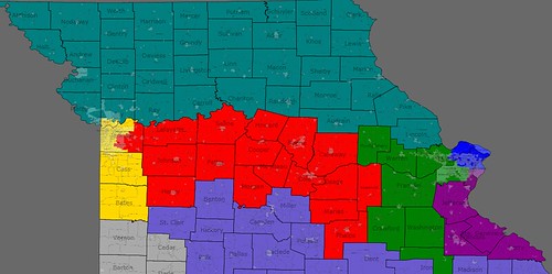
Southern MO map:

http://www.flickr.com/photos/4…

———

District 9: Blaine Lueketmeyer

Residence: St. Elizabeth, Miller County

Old PVI: R+9

Disappeared!

His district is eaten by several others, and he now lives in Jo Ann Emerson’s new 8th. He has little chance to defeat her in primary as her base makes up the vast majority of this district.

But his previous district is now split between the new ones of Skelton, Akin and Carnahan, wi

So why would Republicans sacrifice ole Blaine?

Blaine will lose because he has the least seniority, other than whoever Blunt’s replacement is. But Blunt’s district makes sense–southwest Missouri–as opposed to Blaine’s crazy-shaped current 9th (“Little Dixie” …yeah, good try).

Why else dump Blaine? Because Republicans get a lot in return. Three totally safe districts, one mostly safe one, and they have a chance on at least one, if not two, of the “Democratic” districts. Democrats will like it because it’s a better balance and they may have a chance with Akin in the future. And with Skelton unlikely to make it another decade in Congress (though I hope and pray to God he does) they’re gonna lose one forever if they don’t agree to act now. Basically, you can gerrymander Missouri a lot worse.

Overall, despite its 2008 performance, Missouri is still the ultimate swing state, and having a 4-4 delegation (with one seat that could go to Republicans) seems right.

———

Other Missouri redistricting maps:

http://www.swingstateproject.c…

http://www.swingstateproject.c…

Source:

MO Gov Race – http://www.sos.mo.gov/enrMaps/…  (MO Sec. of State’s office)

Redistricting South Carolina: 2 Black-Majority Seats UPDATED

Ok, so this is my first redistricting diary not focused on Michigan.  I chose the state of South Carolina for several reasons, it’s relatively small, it will probably gain a seat, and that new seat may be a Majority-Minority seat.  I don’t know if the DOJ will require a new Min-Maj seat, or what the recent Supreme Court decision has to do with this.  

The rest of the map I drew with a Republican gerrymander in mind.  I tried to dislodge Rep. Spratt, and I think that I was probably successful.  I also made Rep. Brown and Rep. Wilson safer, in light of their recent competitive races last year.  

This map is incredibly gerrymandered.  I mean incredibly.  I don’t know much about SC, so let me know if I’ve done something wrong.

District 1- Henry Brown (R) Blue

72% White, 19% African American, 6% Hispanic

Drops all of Horry County (Myrtle Beach) in exchange for Beaufort, Hilton Head area.  Drops some heavily African American areas in exchange for more Republican Charleston areas.

District 2- Joe Wilson (R) Green

77% White, 17% African American, 3% Hispanic

This is the most gerrymandered non-VRA seat, mostly so that it can cede it’s black areas to the new 7th District.  It follows the SC-GA border, then winds down to the Columbia area and takes in almost all of Lexington County, where Wilson’s home is located. AA population drops almost 10% and this district is much safer for Wilson.

District 3- TBD (successor of Gresham Barrett) Purple

78% White, 14% African American, 5% Hispanic

Includes all of Oconee and Pickens as well as northern Greenville and Spartanburg Counties and winds down to pick up some conservative Columbia suburbs formerly in Wilson’s district.  This district includes Barretts home but may or may not contain the home of his successor, which could be problematic if he or she is from Anderson County. Black population drops 6%

District 4- Bob Inglis (R) Red

70% White, 22% African American, 5% Hispanic

Includes all of Anderson Couny and the cities of Greenville and Spartanburg.  By far this is the least gerrymandered district in the state.  Because it now grabs Aiken County and due to growing minority populations in North SC, the African American and Hispanic populations actually go up in this district slightly.

District 5- John Spratt (D) Yellow

75% White, 18% African American, 4% Hispanic

I drew this district with the intend of defeating John Spratt, because I doubt that South Carolina Republicans settle for a 3-4 Delegation, especially because 2 districts are VRA.  The African American vote here is nearly halved, and the district now stretches into Horry County and includes all of Myrtle Beach, a Republican stronghold.  I don’t know whether Spratt would win this district, but he may decide to retire rather than find out.

District 6- Jim Clyburn (D) Blue-Green

52% African American, 43% White, 2% Hispanic


This district takes in more of Columbia than before and stretches north into Fairfield, Chester, and Union Counties.  To stay majority African American, and to hurt Spratt, it has now grown several oogie tentacles that slither into some of the more rural African American areas, as well as a few small cities.  Don’t worry though, it remains contiguous.  Despite the additon of another majority Black district, the AA population only falls about 5%

District 7- NEW (D) Gray

54% African American, 41% White, 3% Hispanic


I’ll admit, this district is awfull, but maybe not as awful as it looks at first glance. It starts by taking in the Black neighborhoods of Charleston and North Charleston, the takes in as many black majority tracts as humanly posible without going into Columbia.  I tried to salvage some integrity for this map, so I made sure that there were no oogie tentacles like in the 6th, so give me credit for that at least.

What does everyone think? Are they legal?

Update– Based on comments and criticism, I’ve totally redrawn my map, this time giving Spratt the African American majority seat instead of creating a new one.  This district is  a thousand times less gerrymandered than the last, so I think you’ll all like it much better.

Spratt’s New District is exactly 50% Black

While Clyburn’s is about 55% Black.

To compensate for lost population, Clyburn’s district takes in more of both the Charleston and Columbia areas.


The  new 7th district follows the North Carolina border from Spartanburg to Myrtle Beach, taking up much of what was Spratt’s District.  The other districts remain almost unchanged, although the first and second become a few percentage points more white. I tried very hard to split as few counties as possible, and even though it may look bad, many counties remain compact in even the 5th and 6th Districts.

Redistricting Michigan: Take 2

Lately there has been a lot of Debate over the number of Democratic Congressional Districts that Democrats could gerrymander out of the state of Michigan if they had complete control (right now they hold the Governorship and State House.  They stand a good chance at taking control of the State Senate while the Governor’s race is a tossup).  A few people, namely IHateBush, have said that it is possible to succesfully draw a map that would yield 12 Democratic seats and only 2 Republican seats.  I’ve been trying for several weeks to draw a 12-2 map, meanwhile protecting endangered incumbents (specifically Schauer) and I’ve determined that a 12-2 map would be far overeaching and in a neutral or Republican leaning year might end up 9-5 or worse. I think the best Michigan Democrats could do is create 11 safe or Democrat leaning districts and 3 strongly Republican districts.  I’ve drawn a map that I think does just that, although I still am not entirely confident that we could hold both of my “Thumb” districts in a Republican year.  But without further ado, here’s my map.

District 1 (Bart Stupak D):  Since this is my home district, and I couldn’t face the specter of Tom Casperson or some other Republican becoming my Congressman when Bart Stupak retires, I’ve gone to pretty great lengths to make this one safer.  I added the remainder of Bay County, Isabella County (home to CMU) Clare County, and Roscommon County, all counties that President Obama won.  I took out the Republican leaning counties of Charlevoix, Antrim, Crawford, Oscoda, Otsego, and Montmorency.  Overall Obama’s performance in this district goes from about 50% to about 53%.

District 2 (Vern Ehlers R) this is probably the most gerrymandered looking of all of my new districts, but it has to be if we are going to have a Democrat leaning district in Western Michigan.  It takes in the Dem leaning Counties of Leelanau, Benzie, Manistee, Lake, Mason, and Oceana along the Lake Michigan shore, the Strongly Democratic County of Muskegon, and then tentacles into Kent County and picks up the cities of Grand Rapids, Kentwood, East Grand Rapids, and Wyoming.  Barack Obama won this district 57.2-41.1 giving it a nice, healthy PVI of D+4.3. Vern Ehlers likely would not be reelected to this district.

District 3 (Fred Upton R + TBD [successor to Pete Hoekstra] R) I’ve combined the old 2nd and 6th districts to form this heavily Republican District.  It takes in Ottawa, Allegan, Van Buren, Northern Berrien, and suburban Kent Counties.  Whoever succeeds Pete Hoekstra next year would probably be favored in a Primary against Upton, who is somewhat too moderate for this very conservative district.

District 4 (Dave Camp R) another one of my heavily Republican districts, this one takes in some of the rural and conservative Counties in Northern and Central Lower Peninsula, but it is based in Midland and Traverse City (Grand Traverse County) Barack Obama only won 2 counties in this new district, Gratiot and Clinton.  Dave Camp’s home in Midland is preserved in the new 4th.

District 5 (Open, leans D)  The new 5th district is the one that I would be least confident of us holding in a Republican year, but still in a neutral year it favors us. It has a PVI of about D+2-3 and it includes the Democratic County of Saginaw, about 2/3 of staunchly Democratic Genesee county (minus the city of flint) the Dem leaning Shiawassee County, sparsely populated Republican Counties in “the Thumb” and Tossup St. Clair County. Luckily former Democratic Congressman James Barcia’s home in Bay City is not in this district, for we really could get a more progressive Congressperson from this district. (State Sen. John Gleason, perhaps?)

District 6 (Mark Schauer D) I increased the Democratic performance in this district by drawing strongly Democratic Kalamazoo County out of Upton’s district and into this one.  I also added tossup county Cass and the Democrat leaning portions of Berrien County.  I took out Jackson and Lenawee County as well as the portion of Washtenaw that was in this district.

District 7 (Open, Democrat) It’s high time that Lansing is put into a Democratic district again, and that’s just what I’ve done.  This new district is L shaped and contains Ingham, Jackson, Hillsdale, Lenawee, and Monroe Counties.  Barack Obama won all these counties, except Hillsdale. Obama won the district 56.4-41.9 giving it a 2008 PVI of D+3.5.  If I had to guess what Democrat might win this district, I’d say State Rep. Barb Byrum (daughter of 2000 candidate Diane Byrum), State Sen. Gretchen Whitmer (distinction of being the “most liberal” Senator), or Lansing mayor and Former state Senator Virg Bernero.

District 8 (Gary Peters D) I’ve made this one a bit more Democratic by removing the cities of Rochester and Troy while adding Berkley, Southfield, and the rest of Waterford Township.  Removing the city of Troy also removes a potential future challenger to Peters, State Rep. Marty Knollenberg (son of Joe Knollenberg).  This district should be safe for Peters or a future Democrat if he runs for higher office.

District 9 (Candice Miller R + Dale Kildee D)  In 2002, Republicans drew David Bonior’s (D) Congressional District http://factfinder.census.gov/s… much more Republican, forcing him to retire or face certain defeat at the hands of their preffered candidate, Secretary of State Candice Miller.  It’s payback time.  I’ve drawn the most Democratic parts of Macomb County, including Miller’s home, into a district with exurban Republican Lapeer County, as well as the 90-10 Obama city of Flint, and other staunchly Democratic portions of Genesse County.  This includes Dale Kildee’s home, but he’ll be in his eightees by 2012 so he probably won’t be the one running against Miller, if Miller runs at all.

District 10 (Mike Rogers R) The last Republican district that I drew, the 10th includes fast growing and largely Republican Livingston County (home to Mike Rogers), Northern and Western Oakland County, and Shelby township in Macomb County. I considered drawing Livonia (Thad McCotter’s home) into this district as well, but I don’t want there to be any chance that he returns to Congress

District 11 (Sander Levin D) This distric largely reverts to it’s pre-2002 boundaries.  It now would contain all of Sterling Heights, Warren, Troy, Clawson, and Royal Oak, along with the most Democratic south Oakland Suburbs.  This district would be safe for Levin’s successor (hopefully state Rep. Ellen Cogen Lipton).

District 12 (Carolyn Cheeks Kilpatrict D) Doesn’t change much except that it moves farther south and includes all of Dearborn.  It’s still majority African American and very strongly Democrat.  The only problem with the configuration of this district is that John Dingell lives in Dearborn.  If he is still serving in 2012 (which I doubt) a tendril can be drawn from the 14th District to pick up his home so that he wouldn’t be drawn into Kilpatrick’s district.

District 13 (John Conyers D + Thad McCotter R) Contains all of Northern Detroit and also reaches all the was west to include Redford Township, Livonia, Northville and Plymouth.  There’s no way Thad McCotter could win this majority African American Detroit District.  Safe for Conyers and his successors.

District 14 (Open D) This one looks very much like Lynn River’s old district http://factfinder.census.gov/l… and would probably elect an Ann Arbor Democrat (State Sen. Liz Brater, fmr. State Rep. Chris Kolb, who would be the first openly gay congressman from Michigan, or maybe even Rivers if she wants to get back into politics.) Also includes a large portion of Suburban Wayne County taking in the Democratic cities of Canton and Westland. If John Dingell is still serving and runs for re-election in 2012, then a tendril will have to be drawn to include his home in Dearborn, but when he finally retires it will probably elect someone more progressive.  Obama won this district 64.5-32.6.

What does everyone think of my map? Suggestions, corrections, questions, comments? I want to hear them.

The OpenRedistricting Project

A Yale law school student proposes an idea called The OpenRedistricting Project that I suspect may be near and dear to the hearts of many SSP readers:  

The OpenRedistricting Project has two separate, but interdependent, components. The development of user-friendly, free redistricting software is a necessary step for bringing ordinary citizens into the process. Once that is completed, a social networking site dedicated to monitoring the 2010 redistricting cycle should be created. With these new platforms, the netroots will have a seat at the redistricting table.

The post goes on to explain the concept in much greater detail.  

Just the possibility of getting free redistriciting software makes me fully supportive of the idea.  But the potential to create public awareness and public pressure for better redistricting seems to have real promise for making a difference.  I’m not sure if there’s anything that can be done at the moment to move the ball forward on this idea, but just wanted to bring this to the attention of SSP readers.

By what margin will Bob Shamansky win?

View Results

Loading ... Loading ...

Redistricting 2012 (again): Michigan

I know redistricting diaries are a dime a dozen these days, but I’m going to do one that has never been done before: Michigan (assuming full Democratic control of the process).  Nathaniel90 already drew a split control compromise map found here: http://www.swingstateproject.c…  

Michigan will be losing a seat in 2012, going from 15 to 14.  I think the chances of full Democratic control is about 50-50 or maybe slightly better.  It looks like we have a very good shot at taking back control of the State Senate, while the Governors race is still pretty much up in the air, with presumptive nominee John Cherry lagging in the most recent poll.  But this far out, no one can predict this one yet.

By this map Democrats would presumably hold a 9-5 advantage in Representation.  They currently hold a 8-7 Advantage.  In 2002, when Republicans drew the map, they (Rs) held a 9-6 advantage.  My map protects freshmen Gary Peters and Mark Schauer, while throwing Dave Camp and Mike Rogers into a district together.  It also draws a much more Democratic district for Thaddeus McCotter (or his Democratic successor), presumably eliminating him if he isn’t already gone by 2012.

My map was drawn on microsoft paint, and some of the more detailed borders aren’t exact.  Also my computer has some kind of problem with pixelation or something, so it may appear a little blurry.  Without further ado, here’s my map with district profiles down below the flip.  

District 1– (Bart Stupak D) mostly the same but expands to include Kalkaska, Roscommon, and the rest of Bay County.  Overall becomes slightly more Democratic.

District 2– (TBD[successor of Pete Hoekstra]R) gives up Allegan County in the south, as well as Eastern portions of Ottawa County and the North-West corner of Kent County that was formerly in the district.  Gains Leelanau, Grand Traverse, Missaukee, and Osceola Counties.  This district becomes a bit more Democratic (mostly because it loses strongly conservative parts of Ottawa and Kent Counties) and Barack Obama would have carried this district narrowly, but it should still favor Republicans in the future.

District 3– (Vern Ehlers R) Drops Barry and Ionia County in exchange for some very Conservative areas of Kent and Ottawa Counties.  Becomes more Republican.

District 4– (Dave Camp R + Mike Rogers R) I decided that I would throw these two together because I did not want to eliminate Thad McCotter in case he is defeated by a Democrat in 2010. I put Livingston County (Rogers base and home) in with most of the current 4th District. Dave Camp should be the favorite considering it includes his base of Midland as well as most of his old turf, but I wouldn’t count Mike Rogers out.  The inclusion of Livingston County makes this district more Republican.  Barack Obama would have lost here.

5th District– (Dale Kildee D)  Looks like a combination of James Barcia’s old District and Dale Kildee’s current district.  It drops all of the territory it held in Bay County but gains the more Republican thumb counties of Huron and Sanilac.  However, with Flint as the base of this district and Genesee County making up more than half of the population, this District stays Democratic.

6th District– (Fred Upton R) This is the most gerrymandered district in the state, and yet it only splits one County!  This district looks quite a bit different from it’s current shape  It’s base of Kalamazoo is taken out to make Mark Schauer safer.  In exchange it gets all of Allegan, Barry, and Branch counties and about half of Eaton County.  The loss of Kalamazoo makes this district a lot more Republican, although Barack Obama may have won here, depending on exactly what parts of Eaton County are included.

7th District–  (Mark Schauer D) I think that I succeeded in making Mark Schauer safe from any Republican challenge, but I fear that I may have set him up for a primary challenge from a Lansing area Democrat, as Lansing becomes the new base of this district.  The only part of the old 7th district that I left was Calhoun County (Battle Creek) which is Schauer’s home.  I put in all of Ingham and Kalamazoo Counties and about half of Eaton.  Barack Obama won every county in this district and probably came close to 60% here.

8th District– (Gary Peters D)  It is hard to tell on my map, but according to my plan for the 8th district, Gary Peters would get Madison Heights and Southfield, both extremely Democratic cities (Barack Obama got 88% in Southfield), while dropping the strongly Republican cities of Rochester, Rochester Hills, and Berkley.  The addition of Southfield probably brings Barack Obama to around 60% here.

9th District– (Candice Miller R)  Instead of a “Thumb” district, this district becomes a “Detroit suburbs and exurbs district.” It loses Sterling Heights and Utica in Macomb County, and Huron and Sanilac Counties in “The Thumb,” While picking up some seriously Republican turf in Oakland County, including the suburb Novi that is currently in Thad McCotters 11th District.  It still includes the Republican leaning Exurb St. Clair and Lapeer Counties.

10th District– (Thad McCotter R [Should favor Democrat])  Includes all of Thad McCotter’s current portion of Wayne County, plus the cities of Inkster, Romulus, and part of Dearborn Heights.  The current part of Wayne County in the 11th gave Obama 57%.  That probably bumps up to just under 60% Obama.  Also includes Monroe County, which Obama won 51-47.

11th District– (Sander Levin D)  Changes very little, except that it swaps out Southfield for the rest of Sterling Heights.  Becomes a bit less Democratic, but still favors Levin or his successor.

12th District– (Carolyn Cheeks Kilpatrick D)  One of two VRA protected districts in Michigan.  Population loss will force this district to expand, but it still stays within Wayne County and is majority Black.

13th District–  (John Conyers D)  The other VRA district expands into Dearborn but stays heavily Black and heavily Democratic. (Note that John Dingell’s home is in this new district, but I expect that he’ll have retired by 2012 and if frankly, if Debbie Dingell is holding his seat by then, I really don’t care if she gets stuck in Conyer’s district)

14th District– (John Dingell D)  This district moves out of Wayne County and now takes in all of Washtenaw County as well as Jackson, Lenawee, and Hillsdale Counties.  It is now completely based in Ann Arbor and should elect a liberal, Ann Arbor Democrat.  Barack Obama won three out of the four Counties in this new district.

Questions? Comments? Errors to point out?  Leave ’em in the comments.