Mini Redistricting Contest: Virginia, Part 2

We received three entries (so far) in our mini redistricting challenge for VA: from sawolf, okiedem, and drobertson. But now Dave Wasserman’s gone and added a new wrinkle: He says that the DOJ might force Virginia to junk its likely compromise map and proceed with two separate VRA seats. What kind of map can you come up with that creates two majority-minority districts in the Old Dominion?

UPDATE: SaoMagnifico has a map in the first thread taking another crack at the “compromise” plan.

Mini Redistricting Contest: Virginia

(I’m bumping this one up. Not a single map as yet? Come on, people! – promoted by DavidNYC)

So Politico has some details about an incumbent protection map that’s supposedly been agreed to in Virginia:

Members of Virginia’s House delegation unanimously agreed to a redistricting plan that will protect all of their seats and strengthen the three GOP freshmen who ousted Democratic incumbents last November, POLITICO has learned.

The new map, according to multiple sources in both parties who are familiar with the plan, was crafted in the past month chiefly by Virginia’s eight GOP members. But it has received crucial private support from the state’s three House Democrats – notably Rep. Gerry Connolly, who barely survived reelection last November and whose Capitol Beltway-area district would get a Democratic bump.

The delegation is hoping for legislative approval in three weeks when the politically divided General Assembly convenes a special session.

So here’s the contest: Though the details are sketchy, draw what you think this map might look like using Dave’s Redistricting App. Make sure to read the entire Politico piece – most of the details are on the second page. Dave Wasserman has some ideas (here and here), but what are yours?

UPDATE: Looks like we have three entries so far: sawolf, okiedem, and drobertson. Whaddya think?

The Great SSP Redistricting Contest, Round 1 Results

[A note to the winners: Please email me your address so that I can send you your babka! – DavidNYC]

So, I’m lazy and took my sweet time in writing this up. In my defense, Martha Coakley happened, and I chose to distract myself by working on more datasets for Dave’s App. I won’t steal Dave’s thunder, and I’ll leave it to him to announce any news on his time.

Nevertheless, here are the results from the Great Swing State Project Redistricting Contest, Round 1.

Some specifics first. I received 18 entries that were judgable; if I was missing anything from you, I tried my best to reach out and get everything I needed to judge your entry.

Of the 18 entries, with David’s generosity, I selected two winners: abgin, and MattTX2.

The first, I hope, is of no surprise – abgin’s 28-0 map, I think, made everyone’s jaw drop in its brilliance/hideousness/all-around-awesomeness. His/her entry was simply too good not to reward with babkaness!

For the other 17 entries, there was only one 26-2 plan, from silver spring. Three of you tried 28-0 plans, and the remaining 13 of you gave us 27-1 plans.

I tried to come up with some objective measures to help me consider them. Here are the two I considered:

1. To determine the amount of gerrymandering, I created a “county fragmentation index,” which indicates the number of “unnecessary” splits.

2. I also created a “swing index,” to measure quantitatively the improvements given to each district. I used a “safe line” concept (ala my New York State Senate district diary). Since reasonable people can disagree on what an appropriate safeline is, I evaluated each plan on safe lines at 1% increments from 50% Obama to 60% Obama.

Without further ado, I chose MattTX2 as the second winner. I thought he executed the screwing of Peter King in the most precise way, and as the first entrant, showed that this could be done (something I was skeptical of; I believed that the population simply wasn’t in place for that to happen.) His map also produced the best objective improvements, improving the 27 Democratic districts by an aggregate of 5,600 basis points in the 57-60% ranges, the best among the 27-1 plans. The performance, notably, didn’t drop off in the 54-56% range either. Matt’s map, compactness wise, wasn’t a horrendous gerrymander either; with 26 more county fragments than minimally necessary, this was solidly in the middle of the pack (the median, in fact.)

Here are improvement and county fragment scores for every entry.

I would be remiss in judging, though, if I didn’t mention some other notable entries:

  • Abgin obviously had the loosest defintion of “contiguity”, but I think the award for loosest definition of “water contiguity” goes to andgarden.
  • duffman gets the award for most compact map, creating just 11 more county fragments than necessary.
  • bschak made the best attempts for population equality, acheiving a total deviation of only 3,902.
  • AdmiralNaismith played population equality the loosest, racking up a total deviation of more than 113,000.
  • Alibguy had the best 28-0 plan, yielding the best improvements from 52-60%.

In conclusion, thanks to everyone who participated, to Dave for developing this wonderful time-sink (I could never get GUIs down when programming), and to DavidNYC for giving me this opportunity to judge the contest, and for spreading the glory that is Green’s chocolate Babka! Congratulations again to abgin and MattTX2!

Update: I should better explain what the swing index is: the swing index is, in total, a slightly-adjusted measurement of the Democratic percentage improvement. The index is the sum, across all Democratic districts, of swings toward Obama in basis points.

When I say slightly adjusted, for example, I want to punish someone for unpacking Louise Slaughter’s district. So you have the Obama percentage before (Ob1), and the Obama percentage after (Ob2), and the “Safe line” percentage (SL).

So you have four situations:

1. Ob1 > SL, and Ob2 > SL: the district was above the safeline before, and the new district is above the safeline. The contribution to the swing index from the district is 0.

2. Ob1 < SL, and Ob2 > SL: the district used to be below the safeline, the new district was boosted above the safeline. The contribution to the swing index from the district is Ob2-Ob1, in basis points.

3. Ob1 > SL, and OB2 < SL: the old district was above the safeline, the new district was weakened. The contribution to the swing index from the district is SL-Ob2, in basis points. I did this so that you’re not being punished for an astronomic drop for a district that was much much too safe before, like Louise Slaughters.

4. Ob1 < SL, and OB2 < SL: the old and new districts are both in marginal territory; the new district could be stronger or weaker than the old. The contribution to the swing index from the district is Ob2-Ob1 in basis points. This can be positive or negative.

So I totaled up the numbers from each district, yielding the swing index that you see.

Also, the ones highlighted in green are the highest two indexes for a given safe line.

Lastly, the CFI is the “County Fragment Index” – the number of excess county fragments created over what is minimally necessary for 28 districts with perfect population equality.

Contest Entry: New York 27-1

Photobucket

Edit: I just realized the deadline was of course Eastern standard time. Forgive the foolish Californian. At any rate, I did send my .drf.xml to Jeff in time, but even if I am too late this has been a lot of fun.

For my entry in New York redistricting contest, I decided to create a 27-1 map. I chose to eliminate Peter King and pack as many republicans as possible into Chris Lee’s 26th district.  

I expect all democrats to be reelected. Eliminating the old 3rd allowed me to move Nita Lowry’s district southwards, thereby opening up much of Westchester county to reinforce Hall and indirectly the other upstate districts. I aimed for 55% Obama (i.e. a PVI of D+2) for most of the vulnerable upstate districts. The most vulnerable incumbent is Bill Owens in the 23rd at 53% Obama. In general, I tried to keep incumbents in their main bases of support. Also, I was careful to make sure all incumbents’ homes were actually in their new districts.

I aimed for clean lines where possible; however, I had no compunction about obscene gerrymandering when necessary (e.g. Rochester). Some of the uglier districts where necessary to ensure VRA compliance (Nadia Velazquez’s). Also just for fun, I tried to keep all the NYC bridges within the same district.

All districts are within 1600 or about 0.2% of the average population and all but four are within 1000. Finally, I adjusted the district numbers to reflect the changes.

Now without further ado onto the districts.

Long Island

Photobucket

NY-01

Incumbent: Tim Bishop (D)

Population: 701,285

2008 Results: 54% Obama – 45% McCain

This district stays based in western Suffolk county including Bishop’s home in Southampton. I strengthened it from 51% Obama by grabbing some very blue parts of Islip in exchange for swingy parts of Brookhaven and solid red Smithtown.

NY-02

Incumbent: Steve Israel (D)

Population: 699,873

2008 Results: 54% Obama – 46% McCain

The 2nd stays based in western Suffolk county, including all of Israel’s home in Huntington. I had to weaken this district slightly to strengthen the 1st. I made up for this partly by sending a finger into true blue North Hempstead while moving GOP leaning parts of Babylon into McCarthy’s district.

Photobucket

NY-03

Incumbent: Carolyn McCarthy (D)

Population: 700,667

2008 Results: 56% Obama – 43% McCain

Formerly the 4th, this district takes in most of south eastern Nassau County, including most of McCarthy’s base in Hempstead.

NY-04

Incumbent: Gary Ackerman (D)

Population: 700,640

2008 Results: 55% Obama – 44% McCain

The remnants of Peter King’s district had to go somewhere, and this (formerly the 5th) is where much of it went. I moved the swingy parts of the old 3rd west of Hempstead here, while giving part of north Queens for balance. I also took in the blue parts of Glen Cove. This district drops a fair bit from its old D+12, but should stay blue.

New York City

Photobucket

Queens

Photobucket

NY-05

Incumbent: Gregory Meeks (D)

Population: 699,395

2008 Results: 74% Obama – 26% McCain

Formerly the 6th, this is probably my favorite district, simply because it royally screws Peter King. This stays based in southeast Queens, but stretches along the coast to take in the truly brutal parts of the old 3rd, including all of King’s hometown in Oyster Bay. At 50% African American, it stays VRA compliant and should be a cakewalk for Meeks.

NY-06

Incumbent: Anthony Weiner (D)

Population: 700,140

2008 Results: 61% Obama – 38% McCain

This district, formerly the 9th, is mostly unchanged. It is based in central and south western Queens, with a finger into republican parts of south Brooklyn.

NY-07

Incumbent: Joseph Crowley (D)

Population: 699,985

2008 Results: 72% Obama – 27% McCain

This district sheds its northern half in the Bronx, which instead goes to Nita Lowey. This is balanced out by the Queens part of Gary Ackerman’s old district.

Brooklyn

Photobucket

NY-08

Incumbent: Edolphus Townes (D)

Population: 700,681

2008 Results: 85% Obama – 15% McCain

Formerly the 10th, this district is still based eastern Brooklyn and still majority (56%) African American. I slightly extended the finger into south Brooklyn to take in some of the deep red areas.

NY-09

Incumbent: Nydia Velazquez (D)

Population: 700,803

2008 Results: 87% Obama – 12% McCain

Formerly the 12th, this VRA district continues to take in the majority Hispanic neighborhoods in northern Brooklyn, western Queens and lower Manhattan. In total the district is 51% Hispanic

NY-10

Incumbent: Yvette Clarke (D)

Population: 701,024

2008 Results: 86% Obama – 14% McCain

Formerly the 11th, this district stays deep blue with its 56% African American majority

NY-11

Incumbent: Michael McMahon (D)

Population: 699,849

2008 Results: 57% Obama – 43% McCain

Formerly the 13th, this district gets a big boost with the inclusion of the financial district and Batter Park in southern Manhattan. I also have a couple fingers into deep blue parts along the Brooklyn shore. The core of the district remains Staten Island however.

Manhattan

Photobucket

NY-12

Incumbent: Jerrold Nadler (D)

Population: 699,549

2008 Results: 71% Obama – 28% McCain

Formerly the 8th, this is probably the most gerrymandered district I have. As before it takes in most of the Lower West Side, wanders through lower Manhattan, the jumps across the Brooklyn Bridge to take in much of western Brooklyn

NY-13

Incumbent: Carolyn Maloney (D)

Population: 699,640

2008 Results: 80% Obama – 19% McCain

This districts stays based in eastern Manhatten then jumps accross the Queensboro Bridge and Long Expressway to take in north western Queens.

NY-14

Incumbent: Charlie Rangel (D)

Population: 701,118

2008 Results: 92% Obama – 7% McCain

Formerly the 15th, this district stays based in Harlem and the rest of northern Manhattan. At 44% Hispanic and 28% AA, this is still solidly majority minority.

Bronx

Photobucket

NY-15

Incumbent: Jose Serrano (D)

Population: 699,572

2008 Results: 95% Obama – 5% McCain

At 63% Hispanic, this is the Bronx area VRA district taking in the south west of the borough.

NY-16

Incumbent: Nita Lowey (D)

Population: 699,561

2008 Results: 67% Obama – 32% McCain

Formerly the 18th, this district stays based in New Rochelle, but moves to take in the Bronx parts of the 7th and red parts of Northern Nassau County.

NY-17

Incumbent: Eliot Engel (D)

Population: 699,626

2008 Results: 70% Obama – 29% McCain

This district stays based in the north west Bronx, then stretches along western Westchester to take in the blood red parts of Rockland county.

Upstate

Photobucket

NY-18

Incumbent: John Hall (D)

Population: 701,862

2008 Results: 58% Obama – 41% McCain

We now get to the second benefit of eliminating Peter King. Since a series of NYC districts moved south and west to fill in the old 3rd, I’m able to open up some bright blue parts of Westchester County. Hall’s district, formerly the 19th, now extends much further south, taking in White Plains, part of Yonkers, and Mount Vernon. For balance, I shed Orange county and south western Dutchess county.

NY-19

Incumbent: Maurice Hinchey (D)

Population: 700,165

2008 Results: 55% Obama – 44% McCain

Formerly the 22nd, this district gets the most radical redraw of any in the state. I shed the entire northern half of the district, using Binghamton and Ithaca to strengthen Acuri. Meanwhile, I extend the district south to take in Orange county and the blue parts of Rockland county. Most of Hinchey’s base in Ulster County is still in so she should still be able to hold onto it, but it will definitely won’t be cakewalk anymore.

NY-20

Incumbent: Scott Murphy (D)

Population: 700,715

2008 Results: 55% Obama – 44% McCain

The biggest change here is the addition of deep blue Troy and part of western Albany. Also I have added in Poughkeepsie and swingy parts of south western Dutchess County. I have given Washington county to the 23rd, along with a blue finger running down the west part of the district. This should be a little easier to hold.

NY-21

Incumbent: Paul Tonko (D)

Population: 700,770

2008 Results: 55% Obama – 43% McCain

This district is weakened slightly to help out Scott Murphy and to some extent Bill Owens. To make up for the loss of Troy and part of Albany I extend the district both north and south west. To the north I take in deep red Hamilton County along with GOP parts of Fulton, Saratoga, and Warren Counties. To the south west I take in swing parts of Greene and Sullivan Counties, red parts of Delaware county, and solid blue parts of north Ulster County.

NY-22

Incumbent: Mike Acuri (D)

Population: 700,450

2008 Results: 55% Obama – 44% McCain  

Formerly the 24th, this district gets a significant boost with the addition of Ithaca and Binghamton. I also shed the deep red area north of Rome. Finally to get sufficient population, I added in swingy Syracuse suburbs in south and western Onondaga County.

NY-23

Incumbent: Bill Owens (D)

Population: 701,668

2008 Results: 53% Obama – 45% McCain  

This remains our most vulnerable district in New York. Still I manage to make it a point bluer by shedding the deep red area north and west of Rome and extending the aforementioned finger down the eastern border.

NY-24

Incumbent: Eric Massa (D)

Population: 701,475

2008 Results: 55% Obama – 43% McCain  

Formerly the 29th, this district gets a significant boost from a large chunk of downtown Rochester. I also shed the deep red Western half of the district. Finally I sent out a finger going east to claim the rest of the swing parts of Maurice Hinchey’s old district

Photobucket

NY-25

Incumbent: Dan Maffei (D)

Population: 699,797

2008 Results: 55% Obama – 43% McCain  

This district also gets a bump from parts of Rochester. However, this is then canceled out by the very republican areas in and around northern Oneida County. The end result is a point more competitive, but Maffei should be able to hold it with his base in Syracuse

NY-26

Incumbent: Chris Lee (R)

Population: 700,240

2008 Results: 42% Obama – 57% McCain  

All the republicans in western New York had to go somewhere, so this is it. I added in the deep red western parts of Massa’s district along with any republican leaning areas in Erie and Chautauqa counties.  Meanwhile I moved in swing areas around Rochester or Buffalo into the 27th and 28th.

Photobucket

NY-27

Incumbent: Brian Higgins (D)

Population: 699,327

2008 Results: 57% Obama – 41% McCain  

This district is mostly unchanged, with a bit more of Higgins base in Buffalo. Should be an easy hold.

Photobucket

NY-28

Incumbent: Louise Slaughter (D)

Population: 699,260

2008 Results: 57% Obama – 41% McCain  

This district probably ties the 8th for most gerrymandered. Seriously, Congresswoman Slaughter please for all that is holy move to the other side of Rochester. As it is now this district is D+15. I wanted to share some of that wealth with Maffei and Massa. The result is a serious of fingers taking in all the swing or only lean blue suburbs of Rochester, with just the thinnest sliver running through the downtown area to connect her home. As before I then run along the shore of Lake Ontario to take in northern Buffalo. I realize this district is ugly, but then it already gets a bad rap as the “earmuffs.”

At any rate, that’s my crack at New York. I think that’s about as much as we can strengthen upstate without sacrificing one of our incumbents. If nothing else though, I am convinced we need to get rid of Peter King once and for all.

Full size maps are available at http://s862.photobucket.com/al…

Contest entry: 27-1 New York

I experienced technical difficulties trying to generate JPEGs, and had to run an update on my computer which left me unable to get any images up before midnight, although I did email my .drf file to Jeff before the deadline.  I understand if the lack of timely posted images leaves me ineligible for babka. 🙂  It’s my fault for trying to post on the last night of the contest, I realize.  I now have a statewide map, but my area maps are coming up very weird.

This 27-1 map has all 27 Democratic districts with at least 56% Obama voters.  All districts are contiguous over either land or bridges to the best of my knowledge.  Specific bridges are noted in particular district descriptions.

Unfortunately, I do agree that this looks fairly gerrymandered, but in other respects I like it.

I have 8,941 voters unaccounted-for that I have been unable to find even using the “next unassigned” tool.  Nonetheless, I have gotten all deviations from the theoretically proper district population within the maximum one percent.  

New York State image:

I am going to make further efforts tomorrow or later to generate better area maps, but I think this contest entry may fail for lack of technical acumen on my part.  Still, I offer these districts for whatever value they may provide the SSP community; hopefully there’s enough in this diary to at least help Jeff make sense of my .drf file.

District 1: Tim Bishop’s district, and remains rooted in his Southhampton base.  Instead of comprising all of eastern Suffolk, however, it omits much of the northern shore of Long Island and wends its way through Brookhaven and Smithtown into Islip.  

Strengthened from 52%-48% Obama-McCain under the current districts to 56%-43% Obama-McCain.  73% White, 15% Hispanic, 7% Black, 3% Asian, 2% Other.  Total population 699,044.

District 2:  Steve Israel’s district, which remains centered in his Huntington home base of northwestern Suffolk County (with the exception of the very shore), and includes much of Smithtown in northwestern Suffolk as well, but then tunnels through southern Suffolk County and central Nassau County to reach Jackson Heights, and portions of Corona and Flushing in Queens.

Strengthened from 56%-43% Obama-McCain under the current districts to 57%-42% Obama-McCain.  54% White, 23% Hispanic, 15% Asian, 6% Black, 2% Other.  Total population 700,293.

District 3: the approximate successor to Carolyn McCarthy’s current District 4, although significantly rearranged.  Part of the plan to screw Peter King, whose district has essentially disappeared and who would need to choose between running in any of districts 2 through 6, or 8, none of which are weaker than 57% Obama.  I believe this district may contain Carolyn McCarthy’s home in Mineola, although I am not certain, and adjustments might be necessary.  In addition to Mineola, it takes in a substantial portion of central and southern Nassau County, a Democratic area of western Nassau close to the border with Queens, some neighborhoods of eastern Queens such as the Floral Park and Fresh Meadows areas, much of the south shore of Suffolk County, and Republican-leaning chunk of Brookhaven in central Suffolk County.  Along with districts 4, 8, and possibly 2 and 5, it may contain Peter King’s home.

Like McCarthy’s current 58%-41% Obama-McCain district, this is 59%-41% Obama-McCain.  66% White, 14% Black, 12% Hispanic, 6% Asian, 2% Other.  Total population 700,743.

District 4: the majority-black successor to Gregory Meeks’ current District 6.  Still based around Jamaica, St. Albans, Springfield Gardens, and Meeks’ home in Far Rockaway.  Crosses the border into Nassau County with two distinct “tentacles” serving three purposes, however.  The northern protrusion into Nassau County takes in some majority-black areas just over the border and some Republican areas slightly further in to central Nassau.  The southern tentacle takes in Rockaway to create a land bridge to Far Rockaway and include some heavily Republican areas nearby as well, and then incorporates Republican areas near the southern shore reaching all the way out to around Peter King’s Seaford / Oyster Bay home.  It may or may not include that home.

Weakened from Meeks’ current 89%-11% Obama-McCain to 76%-24% Obama-McCain, but this should not put Meeks in any serious jeopardy.  51% Black, 29% White, 11% Hispanic, 4% Asian, 5% Other.  Total population 698,468.

District 5: the successor to Gary Ackerman’s current District 5.  Still includes northern Nassau, including his Roslyn Heights home area, and reaches into Flushing and other portions of northern Queens just like his current district.  The Queens segment is longer and narrower, however, reaching all the way across the borough past Flushing and through LaGuardia Airport and East Elmhurst to Astoria.  And the Long Island segment extends further out, taking in much of what is now the northern part of Peter King’s district in northeastern Nassau County, and also crossing over to Babylon in southwestern Suffolk County.  Peter King’s home may be included at that crossover point, although it is probably to the south.

Slightly weakened from Ackerman’s current 63%-36% Obama-McCain to 58%-42% Obama-McCain, but Ackerman should still be OK.  69% White, 12% Hispanic, 11% Asian, 6% Black, 2% Other.  Total population 699,091.

District 6: the successor to Anthony Weiner’s current District 9.  Includes much of Forest Hills and nearby portions of Queens (the boundaries may need to be tweaked to include his exact home address), the Ozone Park and Howard Beach areas of Queens, and some Republican areas of southeastern Brooklyn such as Brighton Beach, Manhattan Beach, and Sheepshead Bay.  Also extends a tentacle into Nassau County to take in some Republican areas of western-central Nassau.

Strengthened from Weiner’s current 55%-44% Obama-McCain to 58%-41% Obama-McCain, befitting Weiner recent liberal stands and to increase the odds of holding the seat if he becomes Mayor of NYC.  52% White, 18% Hispanic, 17% Asian, 7% Black, 6% Other.  Total population 697,614.

District 7: the successor to Jerrold Nadler’s current District 8.  Still includes his home neighborhood of the Upper West Side of Manhattan, and some Republican areas of Brooklyn.  Includes less of Manhattan south of the UWS than Nadler’s current districxt, however, and somewhat more of the Republican portions of Brooklyn because it is taking in areas currently belonging to Mike McMahon’s Staten-Island-based 13th, the 12th under this redistricting.  Also, this 7th takes an even more convoluted route to get to most of its Brooklyn territory than Nadler’s current 8th: it goes down the west coast of Manhattan and around the southern tip to the Brooklyn Bridge, then down the Brooklyn coast to the southern tip of the majority-Hispanic District 11 (also taking in some Republican areas of Bay Ridge), then winds up around the 11th and back down around the Park Slope and Ditmas Park northern tip of the new 12th, before expanding to take in Borough Park, Bensonhurst, Bath Beach, and much of Coney Island, Dyker Heights and the remainder of Bay Ridge.  

Roughly the same partisan breakdown as Nadler’s current district, strengthened very slightly from 74%-26% Obama-McCain to 74%-25% Obama-McCain.  61% White, 15% Hispanic, 11% Asian, 9% Black, 3% Other.  Total population 701,117.

District 8: the successor to Joseph Crowley’s current District 7.  Still based in his home neighborhood of Woodside and surrounding areas of Queens, but instead of extending up to the Bronx, it extends out on to Long Island to take in Republican parts of central and southern Nassau County.  It at least comes close to Peter King’s home, and may include it.

Weakened from Crowley’s current 79%-20% Obama-McCain to 61%-38% Obama-McCain.  This should still be sufficient for Crowley, however, and his overly moderate, almost bluedoggish and “white ethnic” political personality should play well in Nassau County.  55% White, 23% Hispanic, 15% Asian, 4% Black, 4% Other.  Total population 700,800.

District 9: the majority-black successor to Ed Towns’ current District 10, covering roughly the same areas in Bedford-Stuyvesant, East New York and Canarsie, plus some of Downtown Brooklyn and a bit of Williamsburg.

Very similar partisan breakdown, 90%-10% Obama-McCain as opposed to the current District 10 91%-9% Obama-McCain.  55% Black, 22% White, 15% Hispanic, 4% Asian, 3% Other.  Total population 699,196.

District 10: the majority-black successor to Yvette Clark’s current District 11.  Still centered in Crown Heights, Brownsville and Flatbush, but takes in Republican areas around Gravesend, Ocean Parkway and Manhattan Terrace rather than the more Democratic Park Slope.  

Weakened to 78%-21% Obama-McCain from 91%-9% Obama-McCain in the current District 11, but 78% Obama should be strong enough.  54% Black, 30% White, 8% Hispanic, 5% Asian, 3% Other.  Total population 698,631.

District 11: the majority-Hispanic successor to Nydia Velasquez’s current District 12.  Somewhat more similar to the original “Bullwinkle” version of her district, this takes in Hispanic neighborhoods on the Lower East Side of Manhattan; Red Hook, Sunset Park, East Williamsburg, Bushwick, and Cypress Hills in Brooklyn; and Hunter’s Point and Long Island City in Queens.  It also includes Velasquez’s home neighborhood of Williamsburg in Brooklyn and Asian neighborhoods in Manhattan’s Chinatown.  Note that the Manhattan and Brooklyn sides of the district are connected by the Manhattan Bridge and the Williamsburg Bridge.

Very similar partisan breakdown to current District 12, 87%-13% Obama-McCain rather than the current 86%-13% Obama-McCain.  51% Hispanic, 20% White, 14% Asian, 11% Black, 4% Other.  Total population 698,823.

District 12: the successor to Mike McMahon’s current District 13.  Still based in Staten Island, but extends into more Democratic neighborhoods of Brooklyn than the current incarnation, especially Park Slope.  

Strengthened to 56%-43% Obama-McCain, compared to 49%-51% Obama-McCain in the current District 13.  65% White, 13% Hispanic, 9% Black, 9% Asian, 3% Other.  Total population 702,424.

District 13: the successor to Carolyn Maloney’s current District 14, but based purely in Manhattan (omitting the Astoria/Long Island City portions of her current district), adding to her Upper East Side and Midtown base more West Side and downtown neighborhoods than her current district, such as Clinton/Hell’s Kitchen, Chelsea, the West Village and much of the Financial District.

Strengthened slightly to 81%-18% Obama-McCain from 78%-21% Obama-McCain.  72% White, 11% Hispanic, 9% Asian, 5% Black, 2% Other.  Total population 700,061.

District 14: the majority-minority successor to Charlie Rangel’s current District 15.  Still based in Harlem, but instead of extending down the west side of Manhattan to Morningside Heights and the northern Upper West Side, it crosses over a number of Harlem River bridges to the Morris Heights, University Heights and High Bridge neighborhoods of the southwestern Bronx.  It also includes Rangel’s traditional representation of the Riker’s Island prison, connected by the Triboro Bridge, a largely unpopulated portion of northern Queens, and dedicated bridge to Riker’s Island.

Similar partisan breakdown to the current District 15: 95%-5% Obama-McCain compared to the current 93%-6% Obama-McCain.  55% Hispanic, 35% Black, 6% White, 1% Asian, 2% Other.  Total population 699,859.

District 15: the majority-Hispanic successor to Jose Serrano’s current District 16.  Still occupies a similar area of the South Bronx, although it is shifted slightly to the east, including the Hunt’s Point and Soundview neighborhoods but losing the above-discussed areas in Morris Heights, University Heights and High Bridge to District 14.

Similar partisan breakdown to current District 16: 93%-6% Obama-McCain as compared to the current 95%-5% Obama-McCain in District 16.  61% Hispanic, 28% Black, 6% White, 2% Other.  Total population 701,023.

District 16: the successor to Eliot Engel’s current District 17.  Based in his home neighborhood of Riverdale and including other portions of the northern Bronx as Engel’s current district does, but rather than only extending up the river to Rockland County, it takes in Republican areas of Rockland as well as a number of other Republican areas in the suburbs north of New York.  In particular, it takes in Republican portions of Yonkers and Eastchester in Westchester County; Yorktown and much of Somers in northern Westchester; more than half of Putnam County; and East Fishkill and LaGrange in southern Duchess County.  It is worth noting that the Metro-North New York commuter rail system extends even slightly beyond this district, to Poughkeepsie west of this district and Dover Plains and Wassaic to the east and northeast, so this is still essentially a district of New York City commuters.

Weakened to 60%-39% Obama-McCain from the current 72%-28% Obama-McCain, but Engel should be able to handle it– especially because I believe the heavily-Republican areas of Ramapo in Rockland that Engel is given here are Orthodox Jewish areas that may be won over by the fact that Engel is himself Jewish and has fairly hawkish/pro-Israel views on Middle East issues.  59% White, 22% Black, 14% Hispanic, 4% Asian, 2% Other.  Total population 701,212.

District 17: the successor to Nita Lowey’s current District 18.  Although it contains her hometown of Harrison and much of the rest of eastern Westchester, it extends through the eastern Bronx, across the Throgs Neck Bridge, and along the northern shore of Long Island to take in much of northeastern Suffolk County.

Weakened slightly to 60%-40% Obama-McCain from 62%-38% Obama-McCain for Lowey’s current District 18, but not enough to hurt Lowey, especially because the Long Island suburbs are a reasonably good fit for her current district.  66% White, 19% Hispanic, 9% Black, 4% Asian, 2% Other.  Total population 700,635.

District 18: the successor to John Hall’s current District 19, but while it remains centered around his hometown of Dover, it extends largely up and down the Hudson Valley rather than across it.  Some of Rockland, Orange and a little bit of Ulster County are included, but much of Westchester and portions of Columbia and Rensselaer counties are also included.  On the southern end, in addition to Democratic portions of Yonkers and Mount Vernon, this district also includes a small piece of the northern Bronx.

Strengthened substantially, to 60%-40% Obama-McCain from the current 51%-48% in Hall’s current District 19, which should more than make up for the addition of unfamiliar areas.  72% White, 11% Black, 11% Hispanic, 4% Asian, 2% Other.  Total population 700,716.

District 19: the successor to Scott Murphy’s current District 20 (which previously belonged to Kirsten Gillibrand), this remains fundamentally a northeastern Hudson Valley district, but is redrawn to add more Democratic areas.  From Murphy’s hometown of Glens Falls in Warren County, it winds around (but avoids) Saratoga Springs and Schenectady, takes in the Democratic strongholds of Cohoes and Troy in the Albany area, and includes much of Washington, Rensselaer and Columbia counties.  It also takes in Poughkeepsie and Beacon on the east side of the Hudson Valley, as well as Beacon’s sister city of Newburgh on the west side of the river, and continues down through western Putnam County to Peekskill and parts of Ossining and Cortlandt in northern Westchester.

Strengthened to 56%-43% Obama-McCain from the 51%-48% Obama-McCain of the current 20th District.  83% White, 7% Black, 6% Hispanic, 2% Asian, 1% Other.  Total population 700,109.

District 20: the successor to Paul Tonko’s current District 21, this is centered around Albany and contains his hometown of Amsterdam just like the current district, and does include Rensselaer city on the east bank of the Hudson across from Albany, but rather than including Troy, Cohoes, and Schenectady (which have been reassigned elsewhere) extends through additional counties west of Albany, south to Ulster and even part of Sullivan county, and west to Delaware, Otsego, Herkimer and a little bit of Oneida.

Slightly weakened to 57%-41% Obama-McCain from the 58%-40% Obama-McCain of the current 21st District, but that shouldn’t be enough to cause any trouble for Tonko.  87% White, 6% Black, 4% Hispanic, 2% Asian, 1% Other.  Total population 697,546.

District 21: the successor to Maurice Hinchey’s current District 22, this district still includes his hometown of Hurley and the west bank of the Hudson in Ulster County, and still extends west from there, but it has been substantially reshaped.  It includes the northern suburbs of Binghamton, but no longer Binghamton itself; from there it extends north to include Republican areas of Cortland and Chenango counties and a little bit of Madison.  It no longer includes Ithaca, home of Cornell University, but as compensation it extends through Rockland (where it takes in a number of Democratic areas) and down the bank of the Hudson to Morningside Heights in Manhattan and takes in Columbia University.

Slightly weakened to 57%-42% Obama-McCain from the 59%-39% Obama-McCain of the current District 22.  Hinchey should be able to handle it, taking one for the team to help other Upstate Democrats.  74% White, 11% Hispanic, 9% Black, 3% Asian, 2% Other.  Total population 699,827.

District 22: the successor to the current District 23, the Northern Tier district that Bill Owens won over Doug Hoffman.  In addition to St. Lawrence County, Franklin, Clinton (including Owens’ hometown of Plattsburgh), and much of Essex, Jefferson, and Oswego, this district reaches south to take in the Democratic cities of Saratoga Springs and Schenectady.

Strengthened to 56%-43% Obama-McCain from the 52%-47% Obama-McCain of current District 23.  91% White, 4% Black, 3% Hispanic, 1% Asian, 1% Other.  Total population 700,229.

District 23: the successor to Michael Arcuri’s current District 24.  Includes Arcuri’s hometown of Utica, and nearby Rome, as well as Auburn and Cortland, and most of the part of Tompkins county currently represented by Arcuri.  In addition, incorporates Binghamton and Ithaca itself (currently represented by Hinchey), and reaches down to take in some Democratic portions of Sullivan and Orange Counties (including Middletown), as well as a small piece of Rockland.

Strengthened to 56%-42% Obama-McCain (2% Other) from the 51%-48% Obama-McCain of current District 24.  86% White, 5% Black, 5% Hispanic, 3% Asian, 2% Other.  Total population 700,163.

District 24: the successor to Dan Maffei’s current District 25.  Still centered around Syracuse and including all of the surrounding Onondaga County, but reaches out east to the Oneida area and west to, among other areas, large portions of Ontario and Yates counties.

Same partisan breakdown as the current District 25: 56%-43% Obama-McCain.  88% White, 6% Black, 2% Hispanic, 1% Asian, 1% Native American, 1% Other.  (In other racial breakdowns where the Native American percentage is displayed as 0%, I have not listed it separately.  Total population 699,379.

District 25: the successor to Louise Slaughter’s current district 28, or more precisely the successor to her old Rochester-based district before it got combined with Buffalo in the last redistricting.  Contains Rochester and most of the surrounding Monroe County (including Slaughter’s home in Perinton), with the exception of some heavily Republican areas in the west of the county.

Only 59%-40% Obama-McCain, as compared to the 69-30% Obama-McCain of the current Rochester-to-Buffalo “dumbbell” district.  But Louise Slaughter, and even her successor when she eventually retires, should be safe enough at 59%-40%.  77% White, 13% Black, 5% Hispanic, 3% Asian, 2% Other.  Total population 700,707.

District 26: successor to the current District 26, this is the designated Republican district, home to Christopher Lee.  (At least, it likely includes his Clarence home; a small portion of Clarence is not included, but the boundaries can be tweaked if necessary.)  Ranging from Republican suburbs and rural areas south and east of Buffalo to other Republican rural areas of the state, such as Steuben County in the Southern Tier and much of Hamilton County in the Northern Tier, all the way east to Essex County near the Vermont border.

39%-59% Obama-McCain, as compared to the 46%-52% Obama-McCain currently.  95% White, 2% Black, 2% Hispanic, 1% Other.  Total population 701,016.

District 27: successor to Eric Massa’s current District 29.  Runs from his Corning hometown along the southern New York State border to take in Democratic areas like Elmira city and Salamanca city, and Jamestown city in Chautauqua county, and then extends up to northern Buffalo and the northeastern Democratic suburbs of Buffalo.  Also extends a tentacle up from the Southern Tier to take in the town of Geneseo in Livingston County (more than 10,000 voters split 63%-35% Obama-McCain, due in substantial part to the 5,000-student State University of New York Geneseo campus).

Strengthened to 56%-42% Obama-McCain from the 48%-51% Obama-McCain of Massa’s current District 29.  84% White, 11% Black, 2% Hispanic, 2% Asian, 1% Other.  Total population 701,136.

District 28: the successor to Brian Higgins’ current District 27. Still includes southern Buffalo, much of southern Erie County and much of Chautauqua county, but omits Republican portions of Erie and Chautauqua, and also passes through western Buffalo to Niagara Falls, Tonawanda, North Tonawanda, and Lockport in Niagara County.

Strengthened to 56%-43% Obama-McCain, as compared to the 54%-44% Obama-McCain of the current District 27.  85% White, 8% Black, 4% Hispanic, 1% Asian, 1% Native American, 1% Other.  Total population 700,553.

Contest Entry: Redistricting New York 28-0

I decided to go with a 28-0 map because I think its the most realistic. I dont think the democrats would have spent a million dollars to get Bill Owens elected if they didnt intend on keeping all upstate Democrats. I get 28 Democrat districts by drawing Lee and Massa into the same district and King and McCarthy into the same district and creating a new Long Island seat. My map only leaves two Democrats under 54% Murphy and Owens. I chose these two because the Northeast seems to be the fastest Democrat trending area of New York.  

Image Hosted by ImageShack.us

Image Hosted by ImageShack.us

Image Hosted by ImageShack.us

Image Hosted by ImageShack.us

Image Hosted by ImageShack.us

Image Hosted by ImageShack.us

Image Hosted by ImageShack.us

NY-1: Bishop

Part of Suffolk County

New 54%-46% Obama

Old 52%-48% Obama

White:81% Black:5% Native:0% Asian:3% Hispanic:10% Other:1%

Stays mostly the same loses Smithtown and reaches into the Hispanic part of Islip

NY-2: Israel

Part of Suffolk County, part of Nassau County

New 55%-45% Obama

Old 56%-43% Obama

White:75% Black:9% Native:0% Asian:3% Hispanic:12% Other:2%

Stays mostly the same

NY-3: No Incumbent

Part of Suffolk County, part of Nassau County, part of Queens, part of Bronx

New 57%-43% Obama

Old 52%-47% McCain

White:67% Black:15% Native:0% Asian:4% Hispanic:12% Other:2%

I drew this district from the Bronx to the Conservative areas of Suffolk and Nassau to let the other districts pick up the more Democratic areas of Suffolk and Nassau. I noticed some people drew 3 horizontal districts to solve this problem but I like this way because I keep Israel’s and McCarthy’s districts as close to their current districts as possible. This way also allows me to add a few more Democratic votes to the other districts.

NY-4: King vs McCarthy

Part of Suffolk County, Part of Nassau County

New 57%-42% Obama

Old 57%-42% Obama

White:67% Black:16% Native:0% Asian:3% Hispanic:12% Other:2%

McCarthy keeps most of her old district and King loses most of his republican areas

NY-5: Ackerman

Part of Queens, part of Nassau County

New 57%-43% Obama

Old 63%-36% Obama

White:58% Black:6% Native:0% Asian:21% Hispanic:12% Other:3%

Loses parts of Queens to reach further into Nassau

NY-6: Meeks

Queens

New 87%-13% Obama

Old 89%-11% Obama

White:16% Black:50% Native:1% Asian:8% Hispanic:16% Other:8%

Stays mostly the same

NY-7: Crowley

Queens, Bronx

New 76%-23% Obama

Old 79%-20% Obama

White:31% Black:15% Native:0% Asian:15% Hispanic:36% Other:3%

loses parts of the Bronx and adds parts of Queens

NY-8: Nadler

Upper West Side, Lower East Side, Brooklyn

New 79%-20% Obama

Old 74%-24% Obama

White:50% Black:5% Native:0% Asian:19% Hispanic:23% Other:3%

The 8th becomes a minority district with a 50.25% minority population by picking up minority areas of the Lower East Side and Brooklyn

NY-9: Weiner

Brooklyn, Queens

New 56%-43% Obama

Old 55%-44% Obama

White:62% Black:5% Native:0% Asian:16% Hispanic:13% Other:3%

Adds more of Southern Brooklyn loses some of Queens

NY-10: Towns

Brooklyn

New 92%-7% Obama

Old 91%-9% Obama

White:18% Black:59% Native:0% Asian:3% Hispanic:17% Other:3%

Stays mostly the same

NY-11: Clarke

Brooklyn

New 83%-16% Obama

Old 91%-9% Obama

White:27% Black:55% Native:0% Asian:5% Hispanic:10% Other:4%

Adds some of the heavily republican areas of Brooklyn to keep it out of Weiner’s district

NY-12: Valazquez

Brooklyn, Queens

New 81%-19% Obama

Old 86%-13% Obama

White:25% Black:10% Native:0% Asian:9% Hispanic:51% Other:4%

Removed the southern part of Brooklyn and added more of Queens to make it a little more compact.

NY-13: McMahon

Staten Island, Brooklyn, Manhattan

New 58%-41% Obama

Old 51%-49% McCain

White:72% Black:7% Native:0% Asian:7% Hispanic:11% Other:2%

Adds part of Manhattan, couldnt get the distric Democratic enough without it.

NY-14: Maloney

Upper East Side, Queens

New 78%-21% Obama

Old 78%-21% Obama

White:62% Black:6% Native:0% Asian:11% Hispanic:16% Other:4%

Stays mostly the same

NY-15: Rangel

Harlem, Spanish Harlem, Upper West Side, Washington Heights

New 93%-6% Obama

Old 93%-6% Obama

White:18% Black:29% Native:0% Asian:3% Hispanic:47% Other:2%

Stays mostly the same

NY-16: Serrano

Bronx

New 95%-5% Obama

Old 95%-5% Obama

White:3% Black:30% Native:0% Asian:2% Hispanic:63% Other:2%

Stays mostly the same

NY-17: Engel

Rockland County, Part of Westchester County(Yonkers), Bronx

New 61%-38% Obama

Old 72%-28% Obama

White:62% Black:12% Native:0% Asian:6% Hispanic:18% Other:2%

Loses part of the Bronx to add more of Rockland County.

NY-18: Lowey

Part of Westchester County(Mount Vernon, New Rochelle, White Plains, Rye) part of Putnam County, part of Dutchess County

New 60%-39% Obama

Old 62%-38% Obama

White:69% Black:14% Native:0% Asian:4% Hispanic:12% Other:2%

Has to reach further North with the loss of an upstate district.

NY-19: Hall

Part of Dutchess County(Poughkeepsie), part of Columbia County, part of Orange County, Part of Putnam County, part of Westchester County(Peekskill)

New 54%-45% Obama

Old 51%-48% Obama

White:79% Black:8% Native:0% Asian:2% Hispanic:9% Other 2%

Stays mostly the same.

NY-20: Murphy

Warren, Saratoga, Washington Counties, part of Schenectady, Rensselaer, Columbia Counites

New 53%-45% Obama

Old 51%-48% Obama

White:92% Black:3% Native:0% Asian:1% Hispanic:2% Other:1%

Adds Schenectady and becomes much more compact.

NY-21: Tonko

Albany, Fulton, Montgomery Counties

New 54%-44% Obama

Old 58%-40% Obama

White:89% Black:5% Native:0% Asian:1% Hispanic:3% Other:1%

Has to become larger to allow other districts to become more Deomcratic.

NY-22: Hinchey

Ulster County, Sullivan County, Broome Coumty(Binghamton)

New 54%-44% Obama

Old 59%-39% Obama

White:86% Black:5% Native:0% Asian:2% Hispanic:5% Other:2%

Stays mostly the same. Loses Ithica and adds more rural areas to become less Democratic.

NY-23: Owens

Clinton County, Oswego County, Jefferson County, part of Onieda County(Rome)

New 51%-47% Obama

Old 52%-47% Obama

White:93% Black:3% Native:1% Asian:1% Hispanic:2% Other:1%

Stays mostly the same. I kept Owens district the weakest because he is the newest representative and his district is trending Democratic faster than most. Hopefully by mid decade he will have a more favorable district.

NY-24: Arcuri

Tompkins County(Ithaca), Part of Onieda County(Utica), Part of Monroe County

New 55%-44% Obama

Old 51%-48% Obama

White:90% Black:3% Native:0% Asian:3% Hispanic:2% Other:1%

Has to move further west with the loss of a district. Becomes more Democratic with adding Ithica and Rochester suburbs.

NY-25: Maffei

Onondaga County(Syracuse), part of Monroe County

New 56%-43% Obama

Old 56%-43% Obama

White:87% Black:6% Native:1% Asian:2% Hispanic:2% Other:2%

Stays the same

NY-26: Lee vs Massa

Steuben County, Part of Erie County(Buffalo), Part of Niagara(Niagara Falls)

New 54%-45% Obama

Old 29th 51%-48% McCain

White:82% Black:14% Native:1% Asian:2%  Hispanic:1% Other:1%

Combines some republican areas of both reps and adds most of the black areas of Buffalo and Niagara Falls. If Massa can win his current district in 2010 he should win in 2012 against Lee in the more favorable district.

NY-27: Higgins

Part of Erie County(Buffalo), Chatuaqua County

New 54%-44% Obama

Old 54%-44% Obama

White:88% Black:5% Native:1% Asian:1% Hispanic:4% Other:1%

Higgins wins by comfortable margins so I kept his district the same.

NY-28: Slaughter

Part of Monroe County(Rochester), Part of Niagara County, Orleans County

New 55%-43% Obama

Old 69%-30%Obama

White:79% Black:13% Native:0% Asian:1% Hispanic:5% Other:2%

Loses its parts of Buffalo and Niagara Falls and adds more of Monroe County.  

Contest Entry: 27-1 NY Map

This is my contest entry for Redistricting New York.

The aim of this entry was to create a map where 27 Democrats should be expected to win in New York in any given election. Every Democratic district is 53%+ for Obama. (Notwithstanding the astute observation by jeffmd that Presidential toplines don't mean everything) only 16 Republicans were elected in districts that Obama won by 53% or more (DE-AL, IL-06, IL-10, IL-13, IL-16, IA-04, LA-02, MI-06, MI-08, MI-11, NJ-02, OH-12, PA-06, PA-15, VA-10, and WA-08 [55% or more in bold]).

This entry respects VRA districts in New York City, puts King an a solid Obama district, and solidifies Democratic districts in upstate New York. 

Since New York is expected to lose one Congressional seat, one incumbent's district needs to be eliminated. Although the current Representative from New York 23 is a Democrat, I eliminated Representative Owens district and combined his home with Representative Murphy's NY-20. This map also shifts Representative Massa out of his district (represented here as NY-19). The reason for this is the location of his home in southeastern Steuben County. Steuben County is surrounded by Republican leaning counties, and a way to create a third solid Democratic district in Western New York is to connect Rochester and Syracuse.

Photobucket

Photobucket

Long Island

NY 1 Current Incumbent – Bishop

Population – 700,226

White Black Asian Hispanic
Race 77% 7% 2% 12%
Obama McCain
Old District 54% 44%
New District 54% 46%
Change 0% +2%

NY 1 becomes the southern half of Suffolk County.

NY 2 – Current Incumbent – Israel

Population – 700,711

White Black Asian Hispanic
Race 78% 7% 3% 10%
Obama McCain
Old District 56% 43%
New District 54% 46%
Change -2% +3%

NY 2 contains the central and northeastern portions of Suffolk County. This district remains potentially competitive, as the district vote for Obama was 53%.

Of all of the districts drawn on this map, this is probably the hardest one to justify – going from a district where Obama won with 56% in 2008. The only solace that I have is that a) Republicans rarely win districts where Obama won with 53% or greater, and b) there are plenty of Republican precincts in Nassau in Suffolk counties, especially along the border and along the northern shore. This, then requires a couple of decisions that need to be made. First, you could divide up Nassau and Suffolk counties east-west as exemplified by Answer Guy with a historical discussion here. Answer Guy's map divides Nassau into seven districts – each taking a portion of the Republican areas on Long Island.

NY 3 – Current Incumbent – None

Population – 700,454

White Black Asian Hispanic
Race 70% 13% 4% 11%
Obama McCain
Old District 47% 52%
New District 55% 44%
Change +8% -8%

Unlike other maps for this contest, I did not feel the need to split up Long Island – just moving the pieces around could create four Democratic-leaning districts (and BTW, and FWIW, WA 1 is connected by Ferry between Edmonds and Kingston).

This configuration of NY 3 draws Representative King out of the district. Even if he were to decide to run in the district, and not against Representative McCarthy in his NY 4, he would face a district where Obama received 55% of the vote.

The district is split into two areas, those parts of Hempstead adjacent to Queens and the portion of Hempstead adjacent to Suffolk County. The two areas are connected through Long Beach.

NY 4 – Current Incumbent – McCarthy

Population – 700,121

White Black Asian Hispanic
Race 77% 5% 9% 9%
Obama McCain
Old District 58% 41%
New District 54% 46%
Change -4% 5%

Photobucket

This is perhaps my ugliest looking district, but Representative McCarthy should be able to retain his seat under this configuration. The district encompasses the northern part of Nassau County, some Republican areas of Hempstead, and the North and West portions of Suffolk County. The district also extends into the Bay Side and Bay Terrace neighborhoods of the Queens.

If Representative King were to run for this seat, he would find its dynamics very unfavorable, with a lot of new constituents with a strong Democratic lean.

NY 5 – Current Incumbent – Ackerman/King

Population – 700,231

White Black Asian Hispanic
Race 54% 9% 20% 14%
Obama McCain
Old District 63% 36%
New District 60% 39%
Change -3% +3%

NY 5 could be considered a New York City district, as it stretches from the Bronx through Queens into North Hempstead and Republican areas of Hempstead (including Representative King's Seaford neighborhood).

New York City

NY 6 Current Incumbent – Meeks

Population – 700,218

White Black Asian Hispanic
Race 16% 51% 8% 16%
Obama McCain
Old District 89% 11%
New District 86% 13%
Change -3% +2%

This is a VRA district, and it does not change much from the current district. It does add all of the Rockaways.

NY 7 Current Incumbent – Crowley

Population – 700,095

White Black Asian Hispanic
Race 41% 9% 11% 34%
Obama McCain
Old District 79% 20%
New District 70% 29%
Change -9% +9%

Like the existing district, there are two distinct areas of the district. Instead of going North, NY 7 now orientates South, from Woodside and Hunters Point, through Ridgewood and Bushwick, and Woodhaven. From there, the district cuts into Jamaca Bay, Floyd Bennet Field and Marine Park to connect to Seagate, Coney Island, Brighton Beach and Manhattan Beach.

This is a minority-majority district.

NY 8 Current Incumbent – Nadler

Population – 700,295

White Black Asian Hispanic
Race 52% 11% 15% 20%
Obama McCain
Old District 74% 25%
New District 87% 13%
Change +13% -12%

NY 8 is now entirely a West Side/Lower Manhattan district.

NY 9 Current Incumbent – Weiner

Population – 700,395

White Black Asian Hispanic
Race 26% 11% 17% 42%
Obama McCain
Old District 55% 44%
New District 76% 23%
Change +21% -21%

NY 9 takes what was lost from NY 7 – crossing from the Queens into the Bronx over the Bronx-Whiteshone Bridge. The district is a minority-majority district.

NY 10 Current Incumbent – Towns

Population – 700,417

White Black Asian Hispanic
Race 24% 52% 4% 16%
Obama McCain
Old District 91% 9%
New District 84% 16%
Change -7% +7%

Photobucket

NY 10 loses the Willamsburg neighborhood and areas toward the west, and gains Republican areas in Manhattan Terrace. The district remains an African-American majority district.

NY 11 Current Incumbent – Clarke

Population – 700,102

White Black Asian Hispanic
Race 49% 15% 16% 16%
Obama McCain
Old District 90% 9%
New District 60% 40%
Change -30% +31%

The district extends from Representative Clarke's home precinct in Prospect Gardens in the north to Bath Beach in the south. While NY 11 is no longer an African-American majority district, it remains a minority-majority district. Because it takes in many of the Republican precincts in Queens, Obama's percentage in the district drops to 60%.

NY 12 Current Incumbent – Velazquez

Population – 700,391

White Black Asian Hispanic
Race 22% 50% 4% 20%
Obama McCain
Old District 86% 13%
New District 91% 9%
Change +5% -4%

NY 12 is now the second African-American majority district located entirely in the Queens. The district encompasses the Crown Heights and Prospect Heights neighborhoods as well as the Williamsburg neighborhoods. On the western edge of the Queens, a finger stretches south to pick up Representative Velazquez's home precinct in Carroll Gardens.

It is possible that neither Nydia Velazquez nor Yvette Clarke would be happy in their districts, since Representative Clarke will represent the more Hispanic-leaning district, while Representative Velazquez will represent an African-American majority district. However, this could be easily rectified. First, in my original map (before I learned what precinct each representative lives in), I had Representative Clarke in NY 12 (and she now is the Northernmost precinct of NY 11). Second, since Representative Velazquez is a renter, it is possible that she could subsequently move into the then open NY 11.

NY 13 Current Incumbent – McMahon

Population – 700,091

White Black Asian Hispanic
Race 67% 9% 6% 15%
Obama McCain
Old District 49% 51%
New District 60% 39%
Change +11% -12%

All of Staten Island remains in NY 13, and the district crosses into Brooklyn over the Verrazano-Narrows Bridge. From the bridge, the district heads north along the New York Bay into the Red Hook and Gowanus neighborhoods.

This composition makes the swing district a reliable Democratic district. Obama won 60% in this district.

NY 14 Current Incumbent – Maloney

Population – 700,256

White Black Asian Hispanic
Race 61% 8% 9% 19%
Obama McCain
Old District 78% 21%
New District 80% 19%
Change +2% -2%

NY 14 retains much of its current shape – although it does go a bit further north to encompass Rikers Island. Representative Maloney should be happy, as Obama won 80% of the vote here.

NY 15 Current Incumbent – Rangel

Population – 699,954

White Black Asian Hispanic
Race 14% 30% 3% 50%
Obama McCain
Old District 93% 6%
New District 91% 8%
Change -2% +2%

Photobucket

Charlie Rangel may face a stiff primary challenge in this district where Obama won 91% of the vote. The district loses portions of the Upper West Side for the Norwood and Olinville neighborhoods in the Bronx. The district does retain most of Harlem.

The district is a majority Hispanic district (just over 50%). 

NY 16 Current Incumbent – Serrano

Population – 700,580

White Black Asian Hispanic
Race 5% 30% 2% 60%
Obama McCain
Old District 95% 5%
New District 93% 6%
Change -2% +1%

60% Hispanic. 93% Obama. Not much more I can say about this Bronx district.

Upstate New York

NY 17 Current Incumbent – Lowey

Population – 700,687

White Black Asian Hispanic
Race 62% 20% 3% 12%
Obama McCain
Old District 62% 38%
New District 62% 37%
Change +0% -1%

Representative Lowey's district extends from the Bronx and follows I-95 and I-695 through Mount Vernon to the Connecticut border. To complete the district, NY 17 extends north along I-84 into eastern Putnam County and southern Dutchess counties.

NY 18 Current Incumbent – Engel

Population – 700,238

White Black Asian Hispanic
Race 70% 9% 5% 14%
Obama McCain
Old District 72% 28%
New District 58% 41%
Change -14% +13%

New York 18 extends into the Bronx to pick up Representative Engel's neighborhood of Fairport goes north through Yonkers into Westchester and Putnam counties. The District crosses the Hudson over I-87, and takes the Republican portions of Rockland and Orange County.

Engel's district takes a hit in order to strengthen Representative Hall. Obama's percentage in the district drops to 58%, which still should be a safe seat for a Democrat.

NY 19 Current Incumbent – None

Population – 700,409

White Black Asian Hispanic
Race 86% 6% 2% 3%
Obama McCain
Old District* 56% 43%
New District 56% 43%
Change +0% -0%

* Percentage for Representative Maffei's current district
Percentage for NY 29 = Obama 48%, McCain 50%

This configuration of upstate New York is necessary to preserve a 27-1 delegation. With Eric Massa's home in Corning in Southeastern Steuben County, the possible routes are to go north to Rochester, north and east to Ithica and Syracuse, or west towards Buffalo. None of these options make much sense and damage the possibilities of creating a Democratic performing district for Representative Arcuri's Utica based district because of the need to add population to NY 22 (or Maffei's Syracuse based district).

1) North to Rochester/Syracuse. This route is problematic for the creation of a sensible (to the eye) district for Representative Arcuri. Since in this formulation, his district spans I-90 and dives south to pick up Ithaca, any finger north puts pressure on Arcuri's district to ensure contiguity. (Also see MattTX2's entry for a good explanation of why going North does not work).

2) West to Buffalo. This route is more logical than going North, but has the effect of making NY 26 an eyesore, when it is possible to create a compact Republican performing district in Western New York and safer Democratic districts throughout upstate New York.

Instead, what I did was to create a district spanning I-90 from Syracuse to Rochester and Democratic portions of Ontario county, which is similar to the existing NY 25. In this district, Obama received 55% of the vote. As I suggested in the intro, 55% is really the safest magic number, with 7 Republicans representing districts 55% plus. Of those 7 Republicans, one Cao won because of scandal, two are in Illinois (where Obama is from), and one is a state institution (Castle). For me, the only head scratchers are the two Pennsylvania districts and WA-8 (but that is a different story).

To sum up, NY-19 is a very safe Democratic district and follows much of the current NY 25, even if it does not contain Representative Massa's (or Representative Maffei's) current residence. This does not pose a Constitutional problem, but long-term, is a relatively compact district that should safely elect a Democrat to Congress. In addition, if Massa is not able to win reelection in 2010 (rated lean Democrat by CQ; Kerry 42%, Gore 43%), the issue then becomes moot. However, since that is not part of the conditions of this contest, I choose to create a compact district between Rochester and Syracuse and elsewhere in upstate New York that are more consistently Democratic performing.

NY 20 Current Incumbent – Hall

Population – 700,079

White Black Asian Hispanic
Race 74% 10% 3% 12%
Obama McCain
Old District 51% 48%
New District 55% 44%
Change +4% -4%

Photobucket

Representative Hall's district, like most of the swing districts in upstate New York is strengthened. The district stretches from the northern portion of Weschester County (including Yorktown and New Castle) to a small portion of Ulster County and includes the Democratic parts of Rockland County and Orange County.

The district becomes a safe seat for Representative Hall, with Obama's percentage at 55%.

As an aside, I think this district looks like a M.U.S.C.L.E. Man, with its head in Ulster County, two arms going from Orange County to Dutchess County, and its two legs stretching into Ramapo and Yorktown and New Castle.

NY 21 Current Incumbent – Tonko

Population – 700,765

White Black Asian Hispanic
Race 89% 6% 2% 3%
Obama McCain
Old District 58% 40%
New District 56% 42%
Change +2% -2%

Photobucket

This Albany-centered district becomes less Democratic to shore up Representative Arcuri's seat, but the district should remain a safe seat for Representative Tonko.

In the Capitol Region area, the district loses Schenectady and gains Saratoga. Outside of the region, the district takes in Republican-leaning portions of Schohare and Greene counties, and Republican areas of Delaware and Ostego counties. Representative Tonko's residence in Amsterdam remains in the district.

NY 22 Current Incumbent – Hinchey/Massa

Population – 700,478

White Black Asian Hispanic
Race 88% 5% 2% 4%
Obama McCain
Old District 59% 39%
New District 55% 44%
Change -4% +5%

This district is drawn for Represenative Hinchey, but would be a good district for Representative Massa should Hinchey (72) retire.

The district stretches along the Southern border of New York from Hinchey's home town of Hurley to Corning in Steuben County. The district also encompasses the Southern portions of Tompkins and Cortland counties and, in the East, the City of Poughkeepsie. The performance of the district does drop to 55% – staying above the potentially competitive line.

NY 23 Current Incumbent – Murphy/Owens

Population – 700,469

White Black Asian Hispanic
Race 93% 3% 1% 2%
Obama McCain
Old District 51% 48%
New District 53% 45%
Change +2% -3%

New York 23 takes in many of the counties in the Adirondack Mountains in upstate New York and then follows the Vermont/Massachusetts border into Dutchess County. 

This district contains most of the current NY 20 and portions of the current NY 23 and 24, but still raises Obama's percentage from 51% to 53%. Most of the increase is due to losing Greene and Delaware counties, in favor of more reliable Democratic Franklin and Clinton counties in the North.

Both Murphy and Owens reside in this district, but this is necessary to create safer districts across the State.

NY 24 Current Incumbent – Maffei

Population – 700,386

White Black Asian Hispanic
Race 91% 4% 1% 2%
Obama McCain
Old District* 52% 47%
New District 55% 43%
Change +3% -4%

* Percentage is for the current NY 23
Percentage for the current NY 25: 56% Obama, 43% McCain

Photobucket

Instead of going east from Syracuse, as Maffei's current district does, this district goes North, picking up large portions of the current NY 23 (Oswego, Lewis, Jefferson, and St Lawrence Counties). This district is Syracuse based, both in population and possess a shared community of interest, with most of the district in the Syracuse TV market (or Watertown market, which overlaps with Syracuse anyway).

This configuration does suggest a swing, but increasingly Democratic district. Obama did get 55% in 2008, but it may have barely gone for Bush in 2004. Perot did well in this district in 92, probably getting close to 25-26% of the vote (compared to 16% in New York and 19% nationwide).

NY 25 Current Incumbent – Arcuri

Population – 700,483

White Black Asian Hispanic
Race 87% 7% 2% 3%
Obama McCain
Old District 50% 48%
New District 54% 44%
Change +4% -4%

Photobucket

District 25 becomes an octopus looking district that stretches from Democratic Schenectady to Democratic Syracuse and Ithaca in the east. The head of the octopus is Representative Arcuri's home county of Oneida. The district also picks up portions of Syracuse. Despite the uglish looking nature of the district, the district gains 4% for Obama from 2008.

The district contains all of Schenectady, Oneida, and Madison counties, as well as portions of Montgomery, Schoharie, Otsego, Cortland, Tompkins, and Canondaga counties.

NY 26 Current Incumbent – Lee

Population – 699,996

White Black Asian Hispanic
Race 94% 2% 1% 1%
Obama McCain
Old District 46% 52%
New District 44% 55%
Change -2% +3%

With this map, Representative Lee is the safest Republican in any of the New England states. This NY 26 takes in his home precinct of Clarence 22 in Erie County, and encompasses most of the Republican leaning counties in Western NY as well as Republican-leaning areas in Western Monroe county. The district is comprised of all of Genessee, Wyoming, Livingston, Yates, Schuyler, Allegany, Cattaraugus, and Chautauqua counties, most of Stuben and the Republican areas of Ontario counties.

NY 27 Current Incumbent – Higgens

Population – 700,487

White Black Asian Hispanic
Race 81% 14% 2% 2%
Obama McCain
Old District 54% 44%
New District 57% 41%
Change +3% -3%

Photobucket

In creating a Republican performing district for Lee, NY 27 is the most immediate beneficiary. NY 27 now is an entirely Erie County district, with the exception of the town of Newstead and parts of Clarence in the Northeast corner (NY 26) and the North and West portions of Buffalo (NY 28).

NY 28 Current Incumbent – Slaughter

Population – 699,977

White Black Asian Hispanic
Race 79% 12% 1% 6%
Obama McCain
Old District 68% 30%
New District 57% 41%
Change -11% +12%

Photobucket

Representative Slaugher's district stays similar in form to her existing district, but includes all of Niagara and Ontario counties and a large portion of Monroe County. The district does include most of Rochester. The Obama performance in the district drops, from 68% to 57%, but a Democrat should remain safe here.

Conclusion

I am proud of the map. Although not every Democratic incumbent may like the map, at least 24 of the 27 current Democratic incumbents will be very safe in every single election. Of the Democratic incumbents, every district gave Obama at least 53% of the vote. The only remaining potential swing districts are NY 1, NY 2, NY 4, NY 23, and NY 25. Of these districts, NY 23 and NY 25 are significantly safer than before, while NY 1, NY 2, and NY 4 are in Democratic leaning areas of Long Island (NY 4 has a significant presence in New York City as well).

I believe that preserving County and City lines are important to the districting process. Communities of interest should not be broken up whenever possible, and I tried to keep towns intact, especially in upstate New York.

To supporters of Representative Massa, I expect that he will succeed Representative Hinchey when he retires.

By what margin will Bob Shamansky win?

View Results

Loading ... Loading ...

Contest Entry: Peter King is Out to Sea

As has been thoroughly discussed in other diaries, New York is likely to lose one House seat in the 2010 census. And given the population trends, the district likely to disappear will be upstate. This presents a problem for Democrats, who now control all but one seat there. If the Democrats keep their monopoly on state government in 2011, they will need to make some uncomfortable compromises: unless a seat is somehow removed from downstate, they will either have to leave one incumbent Democrat without a seat to run in or weaken all upstate Democrats in order to remove Chris Lee. Keeping in mind the pitfalls of the “Dummymander” (PDF), I have made the following choices:

1. To “pair” two upstate Democrats in one seat;

2. To ensure that all downstate seats are safe for current or future Democratic incumbents, including the ones that are not currently safe;

3. To give all but one upstate upstate Democrat a familiar seat that s/he can win;

4. To the extent possible, pack upstate Republican voters in Chris Lee’s seat; and

5. To comply with all contest requirements.

Follow me below the fold for maps, data, and discussion. . .

As a preliminary matter, I will refrain from “hiding the ball” and share overview maps; one for upstate, and another for downstate. In the city especially, districts can be difficult to make out, but I will attempt to clarify below.

Upstate Overview:

Upstate 590

Downstate Overview:

Downstate 590

In general, my discussion will move from west to east, and from upstate to downstate. By no coincidence, this means that higher-numbered districts will be discussed first. We begin, therefore, with western and central New York.

WNY 590

Buffalo 590

Rochester 590

Syracuse


District Population Black% Hispanic% Asian% Obama Votes McCain Votes Obama% McCain% Swing From 2008 Map
28 699,770 13% 5% NA 191,081 130,799 59% 40% R+20%
27 699,850 15% 4% 1% 192,759 123,020 60% 38% D+12%
26 700,982 3% 2% 1% 146,555 172,357 45% 53% R+2%
25 699,439 5% 2% 2% 187,103 154,111 54% 44% R+3%
24 700,615 3% 2% 2% 158,656 136,049 53% 45% D+5%
22 700,635 4% 3% 2% 174,645 147,498 53% 45% R+12%

Who loses?

Eric Massa currently represents NY-29. In a map with 28 districts, there can obviously no longer be one numbered 29, but by no coincidence, on my map there is also no corresponding district. Massa’s Corning home is now in NY-22, which reaches from  the NYC suburbs all the way north to Monroe county and the Rochester suburbs. Maurice Hinchey continues to live in NY-22, and retains most of his political base. However Ithaca is removed and given to NY-24 to strengthen Michael Arcuri. Thus Massa and Hinchey are the two Democratic incumbents I have chosen to pair. My best guess is that Hinchey would retire rather than face this map. I expect that Massa would fare well here. In any case, one of the two must go. For population equity, and (again) to strengthen Arcuri, Dan Maffei’s NY-25 (Syracuse, Wayne, Monroe) is three points more Republican than before. This was one of the more frustrating aspects of my map. However, the district is substantially as it was before, Maffei retains his Syracuse base.

What remains?

From a thousand miles away, it looks as though I have retained the much-derieded “earmuff” district (i.e. NY-28). However, it is substantially different from before. Louise Slaughter retains most of Rochester (i.e. her base) and Niagara falls, but gives up her half of Buffalo. This is sufficient to cause a 20% Republican swing in NY-28. But Neither Slaughter nor her successors should worry: Obama still won the new district 59/40%. In return, Brian Higgins’s NY-27 picks up the rest of Buffalo, and his district swings 12% more Democratic, making it a safe seat. Chris Lee’s NY-26 (Erie, Wyoming, Allegany, Monroe) expands substantially, picking up all of the nasty bits and becoming two points more Republican. I could have made Lee’s district even more Republican, but this would have required (a) touch-point contiguity (not allowed in this contest), or (b) substantially reconfiguring NY-25, NY-24, and NY-23. I considered option (b), but decided against it mainly because I thought there was real value in leaving the cores of existing districts intact. I believe the incumbents would agree. Finally in this region, NY-24. Michael Arcuri had a close call here in 2008. So he gets a district that is 5% more Democratic. To provide for this, I removed the most Republican precincts to the east and added  Ithaca. I would not call the 24th safe, but for Arcuri it should be substantially improved.

We proceed to eastern Upstate:

Albany Troy Schenectady Saratoga


District Population Black% Hispanic% Asian% Obama Votes McCain Votes Obama% McCain% Swing From 2008 Map
23 699,639 4% 2% 1% 146,382 125,538 53% 45% D+3%
21 699,912 6% 3% 2% 183,489 140,360 56% 43% R+5%
20 700,285 4% 3% 1% 176,803 149,128 53% 45% D+5%

(Note that for the sake of space, I will not reproduce images from above).

Who loses?

Paul Tonko’s NY-21 (Albany, Schenectady, Montgomery) becomes 5 points more Republican. However, at 56/43 Obama, it is still reasonably comfortable for him. And in the event, he retains almost all of his former territory. Suffice to say that if Democrats are having trouble in this district, they are likely losing the House of Representatives.

What Remains?

NY-23 (Jefferson, St. Lawrence, Clinton) becomes 3 points more Democratic, and NY-20 (Saratoga, Dutchess) swings 5 points D. Both land at 53/45 Obama. Bill Owens and Scott Murphy both won their special elections in districts that were substantially the same, except more Republican (the 23rd also picks up some Syracuse precincts). If Owens and Murphy cannot win in these districts as I have strengthened them, then one or both should be sacrificed in redistricting. In that respect, 2010 should be revelatory.

The march south continues with a look at NYC’s northern suburbs:

Northern Suburbs

Manhattan Bronx Westchester


District Population Black% Hispanic% Asian% Obama Votes McCain Votes Obama% McCain% Swing From 2008 Map
19 700418 7% 10% 2% 170,996 139,646 54% 45% D+6%
18 700,555 10% 15% 4% 165,531 118,461 58% 41% R+7%
17 700,144 27% 18% 4% 175,408 80,686 68% 31% R+7%

Who loses?

NY-18 takes the greatest hit here, becoming 7 points more Republican, and even reaching down into Long Island. But Nita Lowey has very little to be concerned about. Her Westchester base, though reduced by being parceled out to several surrounding districts, is largely intact. And at 58/41 Obama, it is difficult to imagine a serious Republican challenge. As above, if there’s a tidal wave here, NY-18 is not the first district Dems will need to worry about.

What Remains?

John Hall’s NY-19 (Putnam, Dutchess, Westchester) gets the biggest boost, becoming 6 points more Democratic. It’s probably fair to say that Sue Kelly is out of the running for good. And because the core of Hall’s existing district is retained, he won’t need to worry about unfamiliar and hostile territory. NY-17 does take on some more hostile territory in Sullivan county, but at 68% Obama, Eliot Engel should not lose much sleep.

Finally, we protect Michael E. McMahon and make Peter King walk the plank. Into the city!

Brooklyn

Queens

Nassau

Suffolk 590


District Population Black% Hispanic% Asian% Obama Votes McCain Votes Obama% McCain% Swing from 2008 Map
16 701,167 30% 63% 2% 160,961 8821 95% 5% 0
15 699,479 31% 50% 3% 218,488 13,982 93% 6% 0
14 700,439 6% 14% 13% 217,459 54,510 79% 20% D+2%
13 700,540 9% 13% 12% 108,539 85,063 56% 44% D+14%
12 700,623 12% 49% 10% 168,574 23,627 87% 12% D+2%
9 699,725 8% 21% 18% 130,195 61,300 68% 32% D+25%
8 700,774 3% 10% 10% 192,868 84,698 69% 30% R+9%
7 701,294 14% 40% 14% 141,199 39,762 78% 22% R+3%
5 699,981 4% 22% 23% 135,473 86,728 61% 39% R+5%

The City, Continued:


District Population Black% Hispanic% Asian% Obama Votes McCain Votes Obama% McCain% Swing From 2008 Map
11 700,323 50% 10% 6% 166,981 39,649 80% 19% R+21%
10 700,640 50% 10% 2% 197,163 61,690 76% 24% R+30%
6 701,002 51% 13% 4% 206,280 55,143 79% 21% R+20%
3 700,343 16% 12% 4% 168,982 112,455 60% 40% D+25%
4 700,408 17% 12% 6% 191,113 130,871 59% 40% D+2%
2 700,451 9% 14% 3% 167,660 132,736 56% 44% R+1%
1 699,901 4% 8% 2% 163,358 144,040 53% 47% D+2%

(Note: sorry about the strange table format just above.)

Everything is tied together to some degree here, so I will shift my categorization from above.

Without a doubt, Peter King (NY-3) is the biggest loser. His new district, if you can cal it that, is the purple one that sprawls over my three downstate images from Long Island into Brooklyn. NY-3 is now a 60% Obama district, and probably out of reach for the Republicans (that makes this a 27-1 map). So how did I do it? In a nutshell, I made him walk the plank.

First, I protected the existing white Democrats downstate. Tim Bishop’s NY-1 (Suffolk,The Hamptons) and Carol McCarthy’s NY-4 (Nassau, Hempstead)  both reach out over Long Island Sound into Westchester, but are otherwise substantially the same as before. Gary Ackerman’s NY-5 (Great Neck) is barely changed from before. NY-9 (Queens) is quite strengthened. Whites are now just a plurality, but Weiner keeps his home base, so he should be safe. I made some changes around the edges of NY-2 (Suffolk, Plainview), but nothing that should phase Steve Israel.

Keeping in mind my goal of not disturbing the Democratic incumbents, I at first thought that it might not be possible to sufficiently weaken NY-3 with what was left, considering the accommodations needed for VRA districts. With touch-point contiguity, it would have been a fairly quick job, but without that I had to take some care. The problem is that there are a number of contiguous Nassau and Suffolk precincts that are very white and very Republican. (i.e., King’s base). They would have to be parceled out among the VRA districts, but how? First, NY-11 picks up all of the Republican territory possible in Brooklyn, becoming 21% more Republican. But Yvette Clarke retains here home base and her black majority, so she’s in no trouble.

Now the fun part. NY-10 is still based in Brooklyn and majority black. But it is a whopping 30% more Republican now. How? It reaches across Jamaica Bay into Nassau and Suffolk (I like to think of this as the Republican ferry). Towns is still safe, but King is sunk. Most of the rest of former NY-3’s territory is vacuumed into Greg Meeks’s NY-6 (still black majority and based in Queens, but now reaching accross Nassau to touch Suffolk). NY-3 is thus drawn towards Brooklyn, and more Democrats.

I deal with Staten Island in a similar way. Nadler’s NY-8 retains the Upper West Side (and my present apartment), and hugs a shipping lane near New Jersey to  Raritan Bay and the southern tip of Staten Island. Lots of Republican precincts there go to NY-8, but as you can see from the chart above, Nadler is in no trouble (he also retains his Republican Brooklyn precincts, but he never had trouble there before, so far as I know). NY-13 gets a big boost, taking on much more of Brooklyn. But it’s not so mangled that Staten Islanders are likely to take out blame on Michael McMahon, who now has a solid Obama district.

Wrapping up, NY-14 (the Upper East Side) is much the same, as is NY-12 (Queens, Brooklyn), so Maloney and Velázquez should be happy. In the rest of the city, my no-change-broken-record continues. Crowley’s 7th (Parkchester, Jackson Heights) is sitting pretty. Rangel’s NY-15 is now about 50% Hispanic, but that is because of demographic changes in Harlem, not my fiddling. Serrano’s ultra-Bronx 16th is as it was, and retains the required Hispanic supermajority. All should be pleased with their very familiar districts.

The political trends were in my mind as I drew this map, and to be honest I am still uncomfortable with upstate. But I think there are at least a few solid districts up there, and even if Republicans make gains, they will not be riding back to the majority on this map on the basis of New York wins.

By what margin will Bob Shamansky win?

View Results

Loading ... Loading ...

Contest Entry: 27-1 in New York

New York is a very Democratic state. It voted for Barack Obama by more than twenty-five points.

But it’s not uniformly Democratic. You can’t make 28 63-36 Obama districts, because whilst Obama won the Five Boroughs by somewhere in the region of 1.6m votes, his margin in the rest of the state was only half a million votes, which my very hurried mental arithmetic tells me is about a 55-45% margin.

What’s more, even there the vote is concentrated. Obama recorded convincing victories in major population centres such as Albany, Syracuse, Rochester, Buffalo and Yonkers, but he also lost twenty-six counties in the state.

If NYC was located where Albany is, these hurdles would be much more manageable. One could send out tendrils across the state, pairing the bluest bits of Manhattan with the reddest bits of Hamilton County. But with NYC’s actual position, the best you can do is send a rainbow through Westchester and those unbearably ugly tentacles would in any case peter out somewhere around Delaware and Schoharie counties. [EDIT: Turns out abgin proved me wrong.]

All of which is a very long way of saying that I don’t think a sustainable 28-0 map for Democrats exists. In fact, I don’t think 27-1 can ever be properly secure and if we hadn’t run the table since 2006, I’d be sceptical of 26-2.

So why am I trying for 27-1? Because I want to win this competition, and figure I’ll do better with a more ambitious gerrymander. No, this isn’t an unbreakable map. But it does seem likely to flip one Republican district and to drastically increase the survival chances of at least three Democrats, without making any incumbent more vulnerable than they already are.

I’ve drawn this map with a couple of aims besides those given in the contest rules. Firstly, I’ve attempted to reduce the number of obvious gerrymanders, such as Hinchey’s leg to Ithaca. I’ve paid more attention to this Upstate, whereas in NYC I’ve figured that nobody cares about the present gerrymanders so I can draw some atrocious looking districts when it benefits me. Long Island falls somewhere in between – the lines aren’t clean, but I junked a couple of early drafts where they got too silly.

Secondly, I’ve tried to preserve towns intact, on the basis that keeping counties whole makes the process very difficult, but towns are functional enough as units of local government for that to be used as a defence. This hasn’t applied on Long Island, where the towns are too large, the borders aren’t given in Dave’s app and it makes effective gerrymandering extremely difficult.

Nor have I followed district boundaries in New York, as that would take ages, screw with the VRA districts and give me a tremendous headache for very little benefit. Where possible, however, I have tried to preserve neighbourhoods fairly intact.

Finally, I’ve tried to make districts where constituent service is possible. Some measure of compactness and community of interest has been used as a criterion. Whilst this has prevented me from all the fun you can have with a Long Island Sound district, I did completely ignore this rule for the 9th. But that’s OK, because I was actively trying to make the votes of southern Staten Island irrelevant, and at last I didn’t follow my earlier plan of sticking it into the 11th!

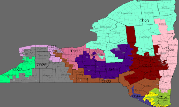
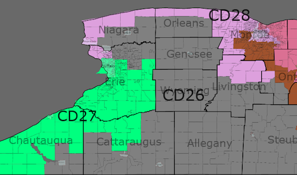
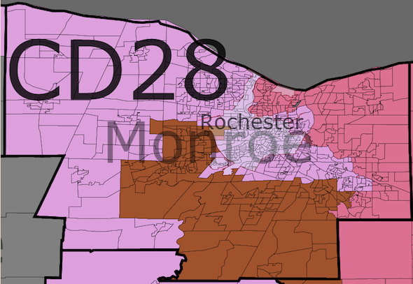
NY 28 (light purple): No incumbent (Louise Slaughter – D)


Population Obama McCain Obama % McCain % Old Obama % Old McCain % White Black Asian Hispanic
704928 185889 125411 59 40 69 30 77 14 1 6


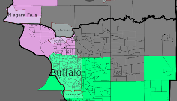
This district – composed of north-west Buffalo, most of Niagara county, the Orleans coast, north-west Monroe and all but the very east of Rochester – does not look like Louise Slaughter’s old district. It looks even more like John LaFalce’s district than the current 28th does. Slaughter doesn’t even live in this district – Perington, where she has her residence, was only just inside the 28th and including it would have shaved two points off Obama’s margin.

On the other hand, the chairwoman of the House Rules Committee is not going to lose a district that includes most of Rochester and a sizeable proportion of Buffalo. She can move and survive. And whilst her retirement in a bad year might give somebody like Maziarz a chance in a great Republican year in a 57% Obama district, a 59% Obama district is pretty much bulletproof.

Hopefully Louise will move and continue to win for another decade. It not, we can at least be sure that her successor will be a reliable vote.

NY 27 (Painful green): Brian Higgins – D, Chris Lee – R


Population Obama McCain Obama % McCain % Old Obama % Old McCain % White Black Asian Hispanic
695684 192096 130007 59 40 54 44 79 14 2 3

Not much change for Higgins’ district. It exchanges some of its sections of Buffalo for NY-28’s and swaps south-east for northern Erie (hence moving Chris Lee’s home into a district he can’t win) but retains seemingly similar lines. Blacker bits of Buffalo, however, raise Obama’s percentage here to 59%. Higgins becomes absolutely safe.

NY 26 (Dark grey): No incumbent (Chris Lee – R)


Population Obama McCain Obama % McCain % Old Obama % Old McCain % White Black Asian Hispanic
694230 136584 179963 42 56 46 52 94 2 1 1

The district retains the core of the old 26th, but replaces suburbs and exurbs of Rochester and Buffalo for much of the Southern Tier. All Cattaraugus and Allegany counties, plus all of Steuben bar Corning, joins eastern Erie (but not Clarence), most of Yates, half of Schuyler and south-western Ontario in the district. In return, the district gives up almost all Niagara as well as the towns of Gates, Greece and Parma.

McCain would have won this district 56-42, so any Republican ought to be safe here, but with its incumbent drawn out, there could be an interesting primary as several Republican State Senators may want to jump ship from that redistricting. Ranzenhofer in the 61st is out, as he lives in Clarence, but Volker in the 59th (just) and Young in the second both live in the district and represent much of it.

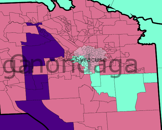
NY-25 (dark pink): Dan Maffei – D


Population Obama McCain Obama % McCain % Old Obama % Old McCain % White Black Asian Hispanic
706912 185238 136930 56 42 56 43 88 6 2 2

Maffei’s district retains Onondaga County, but otherwise is almost entirely different. Whereas previously it went westwards, towards Rochester, here it gives up northern Cayuga, Wayne and north-east Monroe to the 23rd, and heads south-east through territory largely represented by Arcuri. Absorbing all of Madison, Cortland and Chenango, plus most of Otsego and the southern half of Cayuga, it finishes up by taking a tiny sliver of Herkimmer so as to help out NY-20.

Despite its shift in orientation, the district remains at 56% Obama. Only scandal or a 1994 style wave is likely to worry Maffei.

NY-24 (blue verging on purple): Eric Massa – D, Louise Slaughter – D


Population Obama McCain Obama % McCain % Old Obama % Old McCain % White Black Asian Hispanic
698110 190684 142212 56 42 51 48 89 4 3 2

The number is Arcuri’s, but the district is made for Massa. I decided to avoid reshaping Higgins’ district too much, so I couldn’t send the district to Buffalo and needed to keep Binghamton in the 22nd to avoid imperilling Hinchey, so maintaining its orientation towards Rochester was inevitable.

However, its previous southern tier character has been largely removed, since those counties are simply too red to secure Massa. Only Massa’s home in Corning is preserved from Steuben County, from where the district heads east into Chenango and Tioga, before turning north-west.

Arcuri will miss Tompkins County, but an outspoken liberal like Massa needs somewhere like Ithaca in his district. The 24th then takes in some of the better bits of Yates and Schuyler, all of Seneca and the more heavily populated bits of Ontario, including Geneva and Canandaigua, before absorbing most of eastern Monroe, including East Rochester, as well as the 6th, 21st and 23rd wards of Rochester.

Although it stretches from Lake Ontario to the Pennsylvania border, I’d like to think it doesn’t look too horribly gerrymandered. I’m not sure many would agree with me however, and it most certainly is, since Obama got 56% here, an improvement of 8% from the old 29th and 5% from the current 24th. Short of Slaughter deciding to run here, Massa is safe.

NY-23 (mildly feverish green): Bill Owens – D


Population Obama McCain Obama % McCain % Old Obama % Old McCain % White Black Asian Hispanic
705623 149248 130941 52 46 52 47 93 3 1 2

Perhaps less a North Country district now than a Great Lakes-Canadian border district, the district drops its southern protusions in return for Wayne County, the rest of Essex County and the town of Webster in Monroe.

Although the lines are perhaps neater, the percentages don’t change much. Obama stays on 56%, whilst McCain drops a point.

Hoffman now lives in the 23rd, but his three best counties in the special election, Madison, Oneida (part) and Lewis, have now been entirely removed from the district. Wayne County is more conservative than any of them, but Owens is at least no more in danger of teabagging under this map than he is right now. Only one Republican Senator, Joseph Griffo, lives in and represents the new 23rd.

NY-22 (brown): Maurice Hinchey – D


Population Obama McCain Obama % McCain % Old Obama % Old McCain % White Black Asian Hispanic
703054 175214 139995 55 44 59 39 86 5 2 6

I think this district is an improvement on the old 22nd, although it isn’t as compact as I’d hoped. In fact it actually includes one more county than the current district.

This district isn’t as Democratic, but I don’t think Hinchey needs it. He’s a great representative, but he’s not a magnet for controversy and he’s won in tough conditions before.

It begins in Broome – which isn’t as strong as you might think, as northern Broome is conservative enough to partly balance Binghamton, before continuing into strongly Republican Delaware and Greene counties.

The bulk of the district’s population is situated to the south. Hinchey keeps all of Sullivan and Ulster counties, and has two separate bits of northern Orange – one in the north-west, taking in Port Jervis and stopping more or less where the NJ border begins, and one around Middletown, in territory he mostly already represents.

To the north, the district takes pressure off those around it by adding bits of Otsego and Schoharie to Greene and Delaware. In the east, it takes in most of Columbia County, bordering Massachusetts but also takes Schodack in Rensslaer so the 20th can take north-east Columbia.

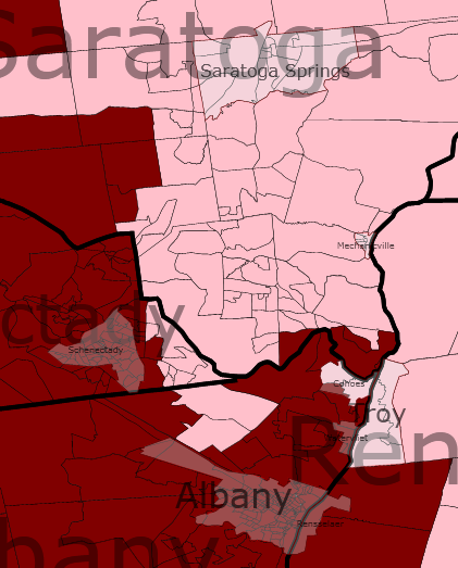
NY-21 (red wine stain): Paul Tonko – D


Population Obama McCain Obama % McCain % Old Obama % Old McCain % White Black Asian Hispanic
703431 186093 144815 55 43 58 40 89 5 2 3

The 21st looks similar, but moves north and west to gain populationand help out the 20th. In the process it gets less Democratic, but at 55% Obama it’s hardly marginal.

Tonko keeps all of Montgomery and Schenechtady and also gains all of Fulton. To this I added bits of Herkimmer and Otsego, Saratoga south of Saratoga Springs, most of Schoharie and almost all of Albany.

Not all, however. Several wards in Albany are moved to the 20th to shore that one up. i can’t imagine state legislators are overjoyed, but at less than 100000 Albany is too small to control a district, and might actually find its influence enhanced by being split.

NY-20 (skin pink): Scott Murphy – D, Michael Arcuri – D


Population Obama McCain Obama % McCain % Old Obama % Old McCain % White Black Asian Hispanic
700948 156774 148240 51 48 51 48 91 5 1 2

This district voted for Obama, but to be honest it leans Republican. It may actually lose us two Democratic incumbents.

Either way, it loses us one. Utica and Glens Falls are combined, throwing Murphy and Arcuri into the same district.

The reasons I picked these two are various, and combine the political and the pragmatic. Firstly Upstate needed to lose a district. Secondly carving up Chris Lee makes his neighbours more vulnerable, and I wanted to keep Massa. Thirdly, rural New York east of Syracuse just doesn’t have enough strong clumps of Democrats – not unless they suddenly annex Vermont and gerrymander that in. Fourthly, Murphy is junior and Arcuri is a weak campaigner. Fifthly, they’re both Blue Dogs and Murphy in particular is an unreliable vote.

The district itself is not just a mash-up of the current 20th and 24th. Much of the 24th has been reassigned to Maffei and Massa, whilst the 20th loses its southern portions.

Instead the district begins Oneida County, housing Rome, which is surprisingly conservative for a city, and Arcuri’s home in Utica. It heads north to take in Lewis county, then takes in most of Herkimmer county (although much more in terms of area than in terms of population).

Next up is Hamilton, Obama’s worst county in the state. It’s followed by Warren, where Murphy lives, and northern Saratoga (including Saratoga Springs). The district then turns down the Vermont border. It keeps all of Washington and heads on into Rensselaer.

Here it picks up Troy and heads across the river into Albany in a desperate bid to find some Democratic votes. It drops marginal Schodack township and replaces it with heavily Democratic Chatham, Canaan and New Lebanon townships in Columbia.

The end result is a 51-48 Obama district, which both the 20th and 24th now are. However, the unfamiliar territory and heavily rural nature makes it a tough hold, however, especially in Republican years. And its more northerly orientation probably means it won’t blue as fast as Hudson Valley districts.

I can’t say for sure how the primary will go. I’d like to think Murphy’s anti-HCR vote will doom him, but he probably represents slightly more of this district already, so I’d favour him to win the primary and lose to a pro-HCR Republican that November.

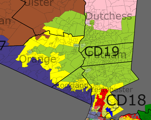
NY-19 (grassy green): John Hall – D


Population Obama McCain Obama % McCain % Old Obama % Old McCain % White Black Asian Hispanic
694702 171172 132308 56 43 51 48 78 8 3 10

Hall will like this much improved district for him. It swaps much of its current incursions into Orange County for northern Dutchess, drops Carmel from Putnam and pushes south into Westchester as far as Mount Pleasant.

The end result is a 5% rise for Obama and a concommitant fall for McCain.

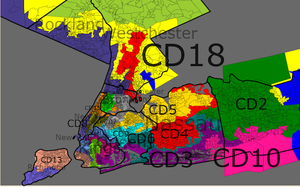
NY-18 (yellow): Nita Lowey – D


Population Obama McCain Obama % McCain % Old Obama % Old McCain % White Black Asian Hispanic
694795 185455 112686 62 38 62 38 65 14 5 15

Rather than throwing her district across the sound, I elected to continue the process of throwing Lowey’s district further north. It begins in Carmel and similarly conservative bits of Putnam and proceeds south into Westchester.

Skirting around Mount Kisco, Bedford and Newcastle, it then proceeds to its effective anchor – southern Westchester. It takes in more of this than it does now – the 17th gives up Mount Vernon and a bit more of Yonkers to this district. The end result is that the margins are largely unchanged for Obama and McCain.

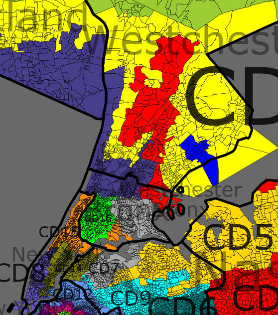
NY-17 (dark blue): Eliot Engel – D


Population Obama McCain Obama % McCain % Old Obama % Old McCain % White Black Asian Hispanic
699892 160041 117574 57 42 72 28 67 11 4 15

Although this is the first district to cross the city lines, this isn’t really a NYC district. It’s much more of a Rockland district. It takes in the whole of that county and expands into Orange.

It then sends a thin line through Westchester, taking in the Yonkers shore, before crossing over in to the Bronx.

Containing Riverdale, Van Cortlandt Park and associated bits of the Borough, the district remains safe.

Nevertheless, whilst Engel – moderate, able to appeal to conservative Orthodox Jews and eminently suited to represented an outer suburbs district – is in no danger, the district loses enough Democrats that Obama only got 57%.

NY-16 (neon green): Jose Serrano – D


Population Obama McCain Obama % McCain % Old Obama % Old McCain % White Black Asian Hispanic
701769 170961 8917 95 5 95 5 2 32 1 62

What’s to say? This district is largely unchanged. It drops its spur into Queens, it spreads a bit further east and it loses Fordham and environs to the 15th. But it’s basically the same extremely Hispanic South Bronx district as before.

NY-15 (orange): Charlie Rangel – D


Population Obama McCain Obama % McCain % Old Obama % Old McCain % White Black Asian Hispanic
706507 200710 13410 93 6 93 6 10 30 3 55

The 15th abandons Queens and heads into the Bronx.

Beginning at Central Park, it heads through Harlem to Washington Heights, before crossing into the Fordham/University Heights area in the Bronx.

In the process, it goes from a minority-majority district to a Hispanic-majority district. At 55% Hispanic, it’s actually more Hispanic than Velazquez’s. With those kinds of numbers, it wouldn’t surprises me if the Justice Department imposes a VRA Hispanic district here anyway.

NY-14 (unfortunate brown): Caroline Maloney


Population Obama McCain Obama % McCain % Old Obama % Old McCain % White Black Asian Hispanic
695589 232945 55306 80 19 78 21 65 4 16 12

Continuing with my habit of confining districts to one borough, NY-14 is yet another district that doesn’t enter Queens. In exchange for its territory there, it heads further south into Manhattan, reaching as far as the Lower East Side and Chinatown.

The white population drops 8% to 65% and Obama improves two points to 80%.

NY-13 (salmon pink): Mike McMahon


Population Obama McCain Obama % McCain % Old Obama % Old McCain % White Black Asian Hispanic
703495 108243 75500 58 41 49 51 56 7 14 19

I know there’s no good reason to split Staten Island, but it’s fun. My only defence is that I tried to keep to existing boundaries to some extent. Lou Tobacco’s assembly district is almost entirely removed, and much of Janele Hyer-Spencer’s district is also lost.

Over the Verranzano Narrows, much more of Brooklyn has to be absorbed. Bay Ridge, Dyker Heights, Gravesend and Bensonhurst stay in the district, which snakes around Borough Park to take in Sunset Park and Red Hook.

At 58% Obama, it’s probably strong enough to deal with the Staten Island backlash for screwing them over. As an added bonus, McMahon would under these lines very likely be succeeded by a Brooklyn Democrat. As a 56% white district, he might even be replaced by a Hispanic.

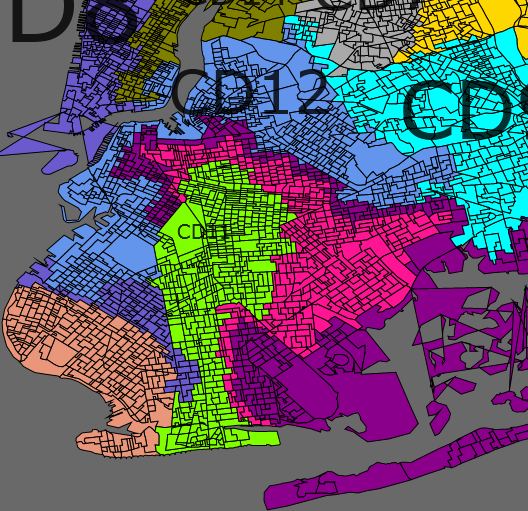
NY-12 (light blue): Nydia Velazquez – D


Population Obama McCain Obama % McCain % Old Obama % Old McCain % White Black Asian Hispanic
701512 138150 26924 83 16 86 13 22 10 13 51

As much a Queens district as a Brooklyn one, this district takes in Williamsburg, Bushwick, Sunnyside, bits of Woodside, South Corona and Elmhurst.

I can’t say much more about this, because I know nothing about NYC. 83% Obama can’t be bad though.

NY-11 (NY-16 green): Yvette Clarke


Population Obama McCain Obama % McCain % Old Obama % Old McCain % White Black Asian Hispanic
704746 203935 27185 88 12 91 9 26 54 5 11

This central Brooklyn district is the standard blacks and Republicans mixture. Ocean Park and similar dead-losses are combined with Flatbush, Crown Heights and Bedford-Stuyvesant for a 54% black and monolithically Democratic district.

Assuming I drew the lines right and Clarke doesn’t have to move, she has nothing to complain about here.

NY-10 (dark pink): Edolphus Towns


Population Obama McCain Obama % McCain % Old Obama % Old McCain % White Black Asian Hispanic
704474 167880 42933 79 20 91 9 30 51 5 11

This district, to my mind, looks like a man in a homburg hat vacuuming. Just so you know…

It’s the same principle as NY-11, but more so. From East New York and Brownsville, it sends a thin tendril through Canarsie into Georgetown before absorbing Republicans around Manhattan Terrace and Home Crest, before continuing on to Coney Island and Sea Crest. Only 79% Obama.

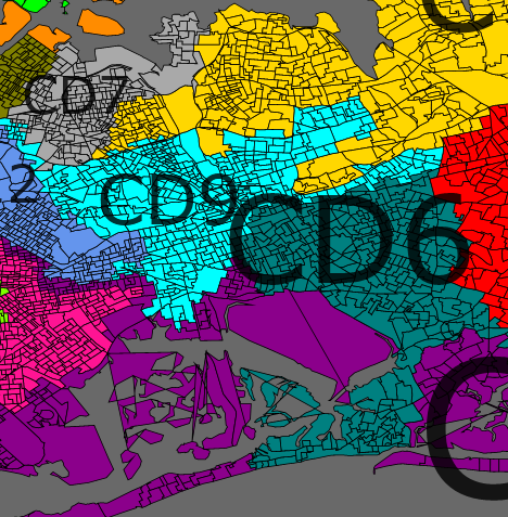
NY-9 (light blue): Anthony Weiner


Population Obama McCain Obama % McCain % Old Obama % Old McCain % White Black Asian Hispanic
697804 120275 87072 58 42 55 44 53 10 9 22

A conscious monstrosity, this district combines central Queens with southern Staten Island via the Rockaway Peninsula, Manhattan Beach and Marine Park. Bits of north-east Brooklyn were added in to pad the margins.

At 58% Obama, it’s not actually as much of an improvement as it might have been, and Weiner is probably a better fit for Brooklyn Jews than Staten Island Italians.

On the other hand, he does retain his Forest Hills base, the district will give him increased recognition in other boroughs if he wants to run for mayor again and Republicans aren’t about to start winning districts that are only 53% white and likely to be majority-minority by 2020.

NY-08 (purple): Jerrold Nadler – D


Population Obama McCain Obama % McCain % Old Obama % Old McCain % White Black Asian Hispanic
705168 236867 50065 82 17 74 26 61 11 8 17

I’d argue this is a substantial improvement on the current 8th in terms of logical lines, but it isn’t compact by any means. From Nadler’s home on the Upper West Side, it snakes down the west side of Manhattan and crosses the East River over the Brooklyn Bridge.

Once in Brooklyn, it takes in Downtown before marching further south into Prospect Park. By this point it’s ridiculously Democratic, such that it absorbs the majority of Borough Park and barely takes a hit for it. At 82% Obama, it’s actually one of the biggest improvements of any district. Not that Nadler needs it, of course.

NY-07 (light grey): Joe Crowley – D


Population Obama McCain Obama % McCain % Old Obama % Old McCain % White Black Asian Hispanic
704836 161725 36669 81 18 79 20 33 26 8 28

Crowley may be the Queens Democratic chair, but his new district is much more Bronx-based. He keeps Queens’ northern shore, taking in Ravenswood, Astoria, Flushing, College Point and Beechurst. He may even keep his home in Woodside, but if not the lines could be changed easily enough.

Most of his territory is in the Bronx, however. In addition to Riker’s Island, his district crosses the Whitestone Bridge to take in Schuylerville, Pelham Park, Parkchester, Co-op City and the rest of the East Bronx.

The district remains majority-minority and becomes rather more so. Whilst white are the largest group, they’re only 33%, and blacks and Hispanics are almost at parity. If Crowley retires, it’s anybody’s guess who replaces him. My money’s on DavidNYC, for the record.

NY-06 (teal): Gregory Meeks


Population Obama McCain Obama % McCain % Old Obama % Old McCain % White Black Asian Hispanic
697850 202891 68157 75 25 89 11 31 50 4 10

I tried the tactic of putting Oyster Bay in this district, but couldn’t make any maps I liked with it. Instead I settled for this more compact district, which is nevertheless a deliberate attempt to make irrelevant the votes of LI Republicans. Jamaica and Far Rockaway form the core of this district, and about 450000 of the district’s inhabitants are 65% black or so.

The other 250000 are mostly LI Republicans. Whilst I took in some black areas just outside the city lines, mostly I took Republican leaning areas like East Rockaway, Malverne and Franklin Square. Pockets of Democratic strength in south-west Nassau, most notable Lynbrooke, were excised.

Note that I may have described these areas wrongly, as I’m doing this from Google maps. Either way, we have a 50.2% black district that voted 75-25 for Obama. That means a lot of Republicans now have their votes wasted

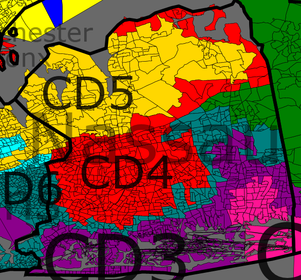
NY-05 (child’s paint yellow):


Population Obama McCain Obama % McCain % Old Obama % Old McCain % White Black Asian Hispanic
694477 123549 81485 60 39 63 36 54 4 23 17

I’ve been much less ambitious in Long Island than some other entries. This is largely because I didn’t want to create fajita strips. I didn’t succeed entirely, but this is a district Ackerman would recognise, whereas other entires have reconfigured NY-05 much more.

The Nassau section is only very slightly changed. Most of the changes have been in Queens. It still includes neighbourhoods like Douglaston and Auburndale, but it’s been expanded further west, up to the Brooklyn border. By skating through Rego Park I drew Ridgewood and the Middle Village into the district.

In general, however, I was surprised how similar the lines were, as the 5th was one of the last districts I drew. The major change is a fairly hefty drop in the Hispanic percentage. If the district goes majority-minority, Ackerman’s replacement is more likely to be Asian than Puerto Rican.

NY-04 (red): Caroline McCarthy


Population Obama McCain Obama % McCain % Old Obama % Old McCain % White Black Asian Hispanic
696289 163148 111809 59 40 58 41 59 10 13 14

NY-04 is much more changed than NY-05, due to the need to remove Peter King. This is an obviously gerrymandered district, stretching well into NYC and being only one voting district wide at two separate points. On the other hand, it’s still 59% Obama, so I’m willing to forgive its aesthetic unpleasantness.

This is no longer a compact Nassau County district. In the city, it goes as far as Kew Gardens and if it doesn’t stray into Jamaica too many times, that’s only because I had to keep NY-06 black-majority.

Outside the city, it’s a mess of tendrils. It snakes its way through North Hempstead (and hopefully includes McCarthy’s home, although I won’t absolutely vouch for that, then sends one tentacle into Hempstead township and some form of stubby proto-foot into Oyster Bay.

The Hempstead one hoovers up the more Democratic portions that NY-06 – places like Lynbrooke, Freeport, South Hempstead and Uniondale. The Oyster bay stump appears to take in Levitttown, Hicksville and Farmingdale, but I could easily be wrong. It certainly takes in bits of Massapequa. This stump isn’t as Democratic as the tendril, since it isn’t designed to boost McCarthy’s numbers. It’s designed to split King’s base.

NY-03 (purple): Peter King – R


Population Obama McCain Obama % McCain % Old Obama % Old McCain % White Black Asian Hispanic
695671 174340 139832 55 44 47 52 73 12 3 10

This is not an unwinnable district for a Republican, but it’s not a nice one. Obama improves eight points to 55%. I wouldn’t expect King to lose by 30 points. But I would expect him to lose, especially against a strong candidate like Suozzi or Meijas, or to run statewide or retire instead.

On the North Shore, the district takes in Glen Cove and the rest of northern Oyster Bay. From there it heads south, narrowing near Plainview as 4th and 2nd both intrude upon it and continuing towards the South Shore.

Once it gets there, it diverges. One side of it goes to Long Beach, largely staying close to the coast but sending up a hook towards Bellmore. On the other side, it moves in to Suffolk, where it mostly hugs the coast through Babylon.

It doesn’t look that different. But it does look like it’ll give King headaches.

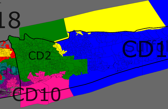
NY-02 (dark green): Steve Israel – D


Population Obama McCain Obama % McCain % Old Obama % Old McCain % White Black Asian Hispanic
694752 162562 141316 53 46 56 43 75 8 3 13

I’m not entirely happy with Long Island. I’m only submitting now because the deadline is fast approaching. And I do think that if this map has a weakness, it’s NY-02.

Not that Steve Israel is doomed. Obama still got 53% here and Israel is an entrenched incumbent whose district isn’t changed overwhelmingly. But if Long Island does become redder, he could face some tougher re-election efforts.

In Nassau, Israel keeps Plainview and the lines are mostly just neatened. In Suffolk, he takes all of Huntington and heads south-west towards Brentwood and Islip.

And if that was all he did, he’d be fine. The problem is he also takes Smithtown, and that’s a bit of an anvil for him.

Then again, he’s a Blue Dog with no trouble raising cash. Smithtown hampers him, but it shouldn’t cripple him.

NY-01 (blue): Tim Bishop – D


Population Obama McCain Obama % McCain % Old Obama % Old McCain % White Black Asian Hispanic
701716 162574 145024 53 47 52 48 84 4 2 8

Bishop’s district isn’t wildly different. It’s the same eastern Suffolk district with the same thin Democratic margins. In the north he drops Smithtown and in the south he gains some of Islip, but I didn’t make huge changes.

Because of this, the Democratic margin doesn’t change much. It improves from 52% Obama to 53%, but mostly I’m relying on Bishop’s continued good relations with his constituents.

If he’s caught up in a scandal, we’ve likely lost the district and if he retires it’ll be a close race. Otherwise, I’d say he’ll probably keep this seat without too much trouble.

Contest Entry: NY 28-0 with 58% Obama or more. Finding limits.

First days I was try to down the maps, but I have much trouble until the last change in the application what help me very much.

The philosophy for my model is so easy. If you need more democratic votes for make more democratic the districts, you must go where they are, you must go to New York City. That gives us a linear model what seems a rainbow for the redistricting.

My model try to find the limits, and I can draw a map with very much 59% Obama districts (D+7) but not all, I need down for some districts to 58% Obama (D+6). The first limit what stop me making more democratic New York districts is the limit of box in the Westchester County for can access with more districts to the area of New York City. The second limit would be the VRA conditions.

For make more compact the districts, but without lose the linear model, you only need down more districts to 58% Obama.

IMAGES:

New York 28-0 G1

New York 28-0 G2

New York 28-0 G3

New York 28-0 G4

DETAILS:

Only E Massa change his district number. He pass from 29th to 26th. All other democratis incumbents keep his number district.

P King and C Lee, the republican incumbents lose their districts.

Sometimes the areas where lives the incumbents are excessively big. I try to include all the areas in their districts, but for the 2nd, 8th, 14th and 15th districts I need to take some parts for other districts. Knowing exactly where live the incumbents would not be difficult to leave they in their districts.

I don’t include McCain results because i can not see the end of the line of results. The line get cut without pass to a second line.

District 01:

– Incumbent: T Bishop

– Dark blue in Long Island.

– Population: 706,022 with deviation of +5,689

– 2008 elections: 59% Obama D+7.

– Racially: Wh 69%; Bl 11%; Hi 16%; As 2%.

District 02:

– Incumbent: S Israel

– Dark green in Long Island, from Nassau until Suffolk.

– Population: 706,389 with deviation of +6,056

– 2008 elections: 59% Obama D+7.

– Racially: Wh 68%; Bl 14%; Hi 12%; As 4%.

District 03:

– Incumbent: vacant

– Purple in western New York, linear district from Chautauqua until Manhattan.

– Population: 698,741 with deviation of -1,592

– 2008 elections: 59% Obama D+7.

– Racially: Wh 62%; Bl 7%; Hi 27%; As 2%.

District 04:

– Incumbent: C McCarthy and maybe P King (R)

– Red in Long Island, linear district from Queens until Suffolk.

– Population: 707,202 with deviation of +6,887

– 2008 elections: 59% Obama D+7.

– Racially: Wh 54%; Bl 15%; Hi 15%; As 9%.

District 05:

– Incumbent: G Ackerman

– Dark yellow in Long Island, from Queens until Nassau.

– Population: 704,967 with deviation of +4,634

– 2008 elections: 59% Obama D+7.

– Racially: Wh 52%; Bl 7%; Hi 14%; As 24%.

District 06:

– Incumbent: G Meeks

– Dark greenish blue in Long Island, from Brooklin until Nassau.

– Population: 694,093 with deviation of -6,240

– 2008 elections: 79% Obama D+27.

– Racially: Wh 32%; Bl 50%; Hi 10%; As 5%. VRA district

District 07:

– Incumbent: J Crowley

– Gray in New York City, from Brooklin until Queens.

– Population: 696,707 with deviation of -3,626

– 2008 elections: 59% Obama D+7.

– Racially: Wh 51; Bl 3%; Hi 24%; As 18%.

District 08:

– Incumbent: J Nadler

– Light purplish blue in western New York, linear district from Erie until Manhattan (Upper West Side).

– Population: 706,893 with deviation of +6,350

– 2008 elections: 59% Obama D+7.

– Racially: Wh 69%; Bl 11%; Hi 16%; As 2%.

District 09:

– Incumbent: A Weiner

– Light tuquoise in Long Island, from Queens until Suffolk.

– Population: 694,038 with deviation of -6,295

– 2008 elections: 59% Obama D+7.

– Racially: Wh 61%; Bl 10%; Hi 18%; As 8%.

District 10:

– Incumbent: E Towns

– Dark pink in New York City, Brooklin.

– Population: 693,891 with deviation of -6,442

– 2008 elections: 82% Obama D+30.

– Racially: Wh 26%; Bl 50%; Hi 13%; As 8%. VRA district

District 11:

– Incumbent: Y Clarke

– Light green in New York City, Brooklin.

– Population: 693,935 with deviation of -6,398

– 2008 elections: 85% Obama D+33.

– Racially: Wh 31%; Bl 50%; Hi 11%; As 4%. VRA district

District 12:

– Incumbent: N Velázquez

– Blue in New York City, from Brooklin until Queens.

– Population: 695,534 with deviation of -4,799

– 2008 elections: 84% Obama D+32.

– Racially: Wh 29%; Bl 11%; Hi 48%; As 8%. VRA district

District 13:

– Incumbent: M McMahon

– Salmon in New York City, from Staten Island until Manhattan by water link.

– Population: 706,942 with deviation of +6,609

– 2008 elections: 59% Obama D+7.

– Racially: Wh 65%; Bl 8%; Hi 13%; As 11%.

District 14:

– Incumbent: C Maloney

– Dark brownish green in New York City and Long Island, from Manhattan until north Suffolk.

– Population: 706,712 with deviation of +6,379

– 2008 elections: 59% Obama D+7.

– Racially: Wh 81%; Bl 3%; Hi 7%; As 6%.

District 15:

– Incumbent: C Rangel

– Orange in New York City, from Manhattan until Queens.

– Population: 695,108 with deviation of -5,225

– 2008 elections: 86% Obama D+34.

– Racially: Wh 44%; Bl 14%; Hi 27%; As 12%. VRA district

District 16:

– Incumbent: J Serrano

– Green in New York City, Bronx.

– Population: 693,589 with deviation of -6,744

– 2008 elections: 95% Obama D+43.

– Racially: Wh 3%; Bl 32%; Hi 61%; As 1%. VRA district

District 17:

– Incumbent: E Engel

– Dark purplish blue in the south of western New York, linear district neighboring Pennsylvania, from Chautauqua until Manhattan (Upper West Side).

– Population: 706,897 with deviation of +6,564

– 2008 elections: 59% Obama D+7.

– Racially: Wh 80%; Bl 5%; Hi 10%; As 3%.

District 18:

– Incumbent: N Lowey

– Light Yellow in northern New York, from Dutchess until Queens.

– Population: 695,784 with deviation of -4,549

– 2008 elections: 59% Obama D+7.

– Racially: Wh 68%; Bl 6%; Hi 16%; As 6%.

District 19:

– Incumbent: J Hall

– Green in northern New York, from Saratoga and Washington until Putnam.

– Population: 693,403 with deviation of -6,930

– 2008 elections: 58% Obama D+6.

– Racially: Wh 68%; Bl 14%; Hi 12%; As 4%.

District 20:

– Incumbent: S Murphy

– Light pink in northern New York, from Jefferson until the Bronx.

– Population: 703,781 with deviation of +3,448

– 2008 elections: 59% Obama D+7.

– Racially: Wh 70%; Bl 19%; Hi 7%; As 2%.

District 21:

– Incumbent: P Tonko

– Dark red in northern New York, linear district from Oswego until the Bronx.

– Population: 706,364 with deviation of +6,031

– 2008 elections: 59% Obama D+7.

– Racially: Wh 67%; Bl 14%; Hi 13%; As 3%.

District 22:

– Incumbent: M Hinckey

– Brown in western New York, linear district from Erie until the Bronx.

– Population: 706,466 with deviation of +6,133

– 2008 elections: 59% Obama D+7.

– Racially: Wh 65%; Bl 9%; Hi 20%; As 3%.

District 23:

– Incumbent: W Owens

– Ligth turquoise in northern New York, from Syracuse until Albany.

– Population: 693,837 with deviation of -6,496

– 2008 elections: 58% Obama D+7.

– Racially: Wh 90%; Bl 5%; Hi 2%; As 1%.

District 24:

– Incumbent: M Arcuri

– Dark purple in western New York, linear district from Ontario until Manhattan.

– Population: 695,810 with deviation of -4,523

– 2008 elections: 59% Obama D+7.

– Racially: Wh 72%; Bl 16%; Hi 8%; As 2%.

District 25:

– Incumbent: D Maffei

– Pink in western New York, from Buffalo until Onondaga.

– Population: 693,428 with deviation of -6,905

– 2008 elections: 58% Obama D+7.

– Racially: Wh 87%; Bl 8%; Hi 2%; As 2%.

District 26:

– Incumbent: E Massa

– Dark gray in western New York, from Steuben until Rockland.

– Population: 700,655 with deviation of +322

– 2008 elections: 59% Obama D+7.

– Racially: Wh 80%; Bl 7%; Hi 7%; As 3%.

District 27:

– Incumbent: B Higgins and C Lee (R)

– Green in western New York, from Erie until Monroe.

– Population: 693,889 with deviation of -6,444

– 2008 elections: 58% Obama D+7.

– Racially: Wh 78%; Bl 14%; Hi 4%; As 1%.

District 28:

– Incumbent: L Slaughter

– Light purple in western New York, Monroe.

– Population: 693,567 with deviation of -6,766

– 2008 elections: 59% Obama D+7.

– Racially: Wh 77%; Bl 13%; Hi 5%; As 2%.

They are four districts in 58% Obama. You can increase three of they until 59% Obama, but the fourth down until 55-56% Obama (D+3 or D+4) because can not access to the New York City area.

Well, sure republicans will hate this model, and maybe democrats smile. New York gives the chance of a good redistricting for democrats.

By what margin will Bob Shamansky win?

View Results

Loading ... Loading ...