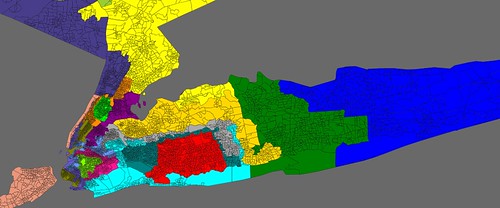
I have a map that completely destroys Peter King’s NY-3 district and will put him on the unemployment line (or to begin a new career as a lobbyist). It also creates a new district in NYC and gives all Democrats in district 1-18 except Tim Bishop basically a safe seat.
But with this map, goodbye Peter King. And good riddance.

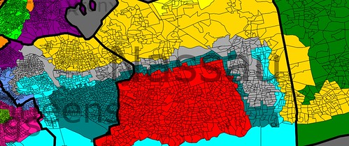
Nassau and Queens Co:

Bronx and Manhattan:

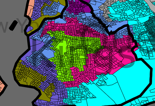
Brooklyn:

NY-1 (blue)- more or less the same. Without knowing what cities are where, I can’t strengthen this district.
NY-2 (green)- made slightly less Democratic by shedding heavily Dem areas in Nassau Co and adding in Republican areas in the Suffolk part of today’s NY-3.
NY-3 (purple) This is the new NYC district that takes in East Bronx, Astoria area in Queens and Williamsburg in Kings. It is safe Democratic. Hopefully it isn’t going to be an invitation for Pedro Espada to run in.
NY-4 (red): This district stays about the same, losing areas in the north which were GOP, but gaining some Repub areas in SE Nassau which were in Peter King’s district. Peter King could run here but would lose.
NY-5 (orange-yellow): Ackerman’s district takes up large parts of King’s district in Suffolk and Nassau, including large parts of Massepequa, King’s base. But the North Shore and Flushing is in this district making it impossible for a GOPer to win.
NY-6 (teal green)- This is Greg Meeks district, and it has been extended to include Peter King’s home of Seaford and other areas which of King’s base. Peter King has no chance here.
NY-7 (gray)- Crowley’s district loses Democratic areas in the Bronx for areas in Nassau county which were part of King’s district. But the Queens areas are minority heavy, and the entire district is just 36% white.
NY-8 (purple) Nadler’s district gets a little less Democratic, losing some areas of Manhattan and gaining Orthodox Jewish areas in Brooklyn.
NY-9 (neon light blue) Wiener’s district gains the Rockaways (heavily Dem) in Queens, Long Beach and some areas in Nassau, and loses some areas in Kings and some in NE Queens. His district is still pretty safe for him.
NY-10, NY-11 (pink and neon green) These still are majority black, but pick up some Repub leaning areas in Brooklyn that are mostly Orthodox and Hasidic Jewish communities.
NY-12 (light blue) This district had to lose 120K residents and is now majority Hispanic.
NY-13 (peach) This district is now completely safe for the Democrats as it adds Manhattan areas to Staten Island.
NY-14 (ugly green) Carolyn Maloney or whomever her replacement is will now need to campaign a little, as Astoria is replaced with Bay Ridge and other marginal areas in Brooklyn using water connectivity. But it is still safe Democrat.
NY-15 (orange) Charlie Rangel’s district is made more black (now 43%) by adding black areas in Bronx and Westchester.
NY-16 (green) Serrano’s majority Latino district is changed little.
NY-17 (dark purple) Eliot Engel’s district adds part of Orange County but is still safe.
NY-18 (yellow) Nita Lowey’s district adds Republican areas in Putnam County and Glen Cove on Long Island, but still should be safe.
I did think about this a little and one possibility is to delete the new NY-3, and push Engel, Lowey, and John Hall into NYC. Under this approach, the idea would be to give the GOP two solid districts upstate (having eliminated Peter King’s district instead of one upstate) and then strengthen the rest of the Democratic districts considerably. This might be better in the long run in giving the Democrats many more safe districts (as opposed to a plan that would eliminate all the GOP districts to obtain a tenuous 28-0 majority, which is also possible)
What is the district size assumption here? I was assuming that NY would again lose 2 districts, but I am not sure of that.
Is the 6th District still majority African American? It would surprise me if it is. (I made a similar map and had to struggle with this)
Adding parts of Harlem to the Staten Island-based is one way to make it more Democratic. Are you sure Anthony Weiner will be OK? Obama did crazy poorly (compared to rest of NYC metro) in that district. Should it really be weakened any more? Otherwise, good stuff.
Interesting map. I like it. I wonder though if this would endanger Crowley, and if people in Albany would want to protect him. I’m no great fan of his, but I wonder if incumbent-protection might win out over party.
in NYC? All my efforts to eliminate just one upstate district actually forced to create a new Hudson River Valley district and eliminate an NYC seat as well.
The new district that kept being created contained all of Columbia, Delaware, parts of Ulster, and most of Orange and Rockland counties.
Who are the 11 people that live in Central Park?
“I have a map that completely destroys Peter King’s NY-3 district”