I wanted to get in on the Wyoming fun, so I decided the state I’d do would be Idaho.
ID-1: More Republican without Ada County, which has trended less Republican over the past few cycles. The counties in the panhandle lean Dem in strong Democratic years.
ID-2: Covers Southern Idaho.
ID-3: Covers all of Ada County and portions of Canyon. Looking at the district, I would estimate it to be about R+8.
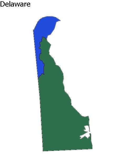
Bonus: Delaware with two districts
DE-1: Covers most of New Castle County and would be D+16. To make it, I looked at a map of New Castle County Council districts and figured out where to divide the county properly.
DE-2: Covers part of New Castle County and all of Kent and Sussex Counties. The PVI would be around D+1 based on 2008, but it probably would be more like R+2 in regular years. It might elect Christine O’Donnell, as both Kent and Sussex voted for her in the Senate race.
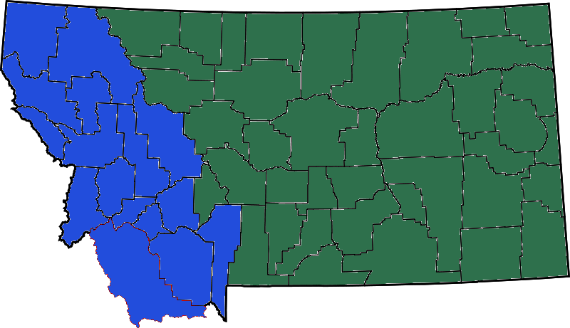
Second Bonus: Montana with two districts.
MT-1: This district would be about R+3 and would certainly be open to electing a Democrat, as it includes most of the places where Democrats perform well.
MT-2: Didn’t do much math on this one, but it would have a Republican PVI.


Montana looks alot like the map of the pre 1990 loss of its second seat. Th Western district gets a few counties near the souther end but gives up a few on the Northern side with the city of Great Falls being the boundary area.
For what its worth I only recall Montana as having one Eastern and Western seat. Same for North and South Dakota–their seats were Eastern & Western seats. The states are rectangled so East-West makes the distance from one to another a little shorter.
Would the Idaho state legislature actually draw that Boise-Nampa seat? It has a Republican lean but it’s definitely winnable by the right Democrat in the right year. Might they not draw a three-district map akin to the current map of Utah instead?
That would be Idaho–Maine-NH-RI-HI seemingly have congressional lines etched in stone. All are fairly logical and mostly nonpartisan.
Idaho has pretty much had the same arrangement with Panhandle seat then the rest of the state. One man one vote forced an ADA solution to equalize population.
Rhode Island splits Providence and has an East and West seat.
New Hampshire splits one county-keeps the two largest cities in different districts.
Maine has pretty much the same lines since 1960 as they split the coastal areas plus split Portland and Lewiston.
Hawaii has had pretty much the same lines since the 1960’s.
Each of the small states have one district that is slightly more democratic then the other but there is geographic harmony and or a desire to have each district not be a single party playground.
In the case of NM-UT-AZ-NV it was only when you see that third seat do you get to drawing lines for specific political purposes as opposed to geographic or regional differences.
If so, this would be good. If they design ID-03 like that, Walt Minnick can come back and win in a friendlier district.
I suspect that the reason he lost this year is people reflexively voting R, similar to what happened with Edwards.
someone should do the math to figure out how many House seats we would need to make sure that each was exactly the same size. It would be more than the Wyoming plan, that’s for sure.
every little problem–some for sure but not all.
MT has 974K
SD has 812K
VT has 621K
AK has 698K
WY has 544K
2009 estimates. So does MT get a second seat? What’s rules for Wyoming?
What about WV it just barely qualifies for three (a great deal for this state) as its congressman are at 600K. Yet it gets only 3 seats under Wyoming (or so it would seem) and several states would get quite a bit more congressman.
Does the overall drift of the Wyoming plan shift seats to the larger states or what? If there are say 560 seats and MT/AK/VT/AK/WY still just have one seat plus some of the other small states like NH & Maine still get just two seats then smaller states are getting a big time shaft on this idea.
and compact but not very savvy politically. We can get a roughly D+0-D+2 district out of it. There’s my solution, excluding the heavily GOP areas in the West (including even parts of Missoula Cnty) and reaching to the Native reservations and including Great Falls.
http://www.flickr.com/photos/5…