As you may know if you haven’t been under a rock, Washington State will be receiving ten districts next year, up from nine this past decade. this is my effort to read the minds of the 5 men responsible for drawing those districts.
In no particular order:
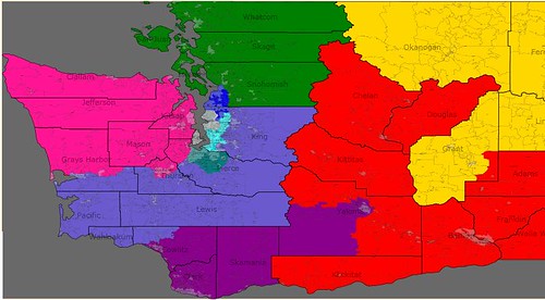
District 2 (green) All four northern counties along with most of Snohomish (Rick Larsen might not quite live here, if so, minor adjustments would resolve this)
District 8 (blue-gray) I could have sworn more people lived in eastern King and Pierce. Because they don’t, this district now extends all the way to the Pacific Ocean, not my best work. Lewis County should let Reichert sleep better on election nights.
District 3 (purple) Basically a dumbbell anchored by Vancouver and Yakima. I’d have liked to add a few more rural Central Washington counties so Rep Beutler could claim she represented Hispanics other than herself but this district is only 11%.
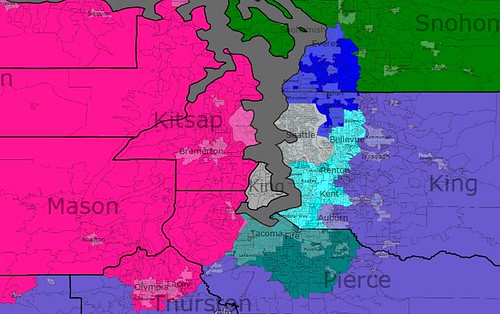
District 6 (pink) If you know the colors of Dave’s App, you’ll noticed that I screwed up. Apparently, though he’s long represented it, Rep Dicks does not live in Tacoma. He’ll be fine here though. I had the opposite problem to Dist. 8, more people live in the Olympic than I was aware of so I had to split Grays Harbor County, nonetheless, with all of Kitsap County and the Olympia area added, Rep Dicks should be quite content.
And now to some districts I’m not ashamed of.
District 1 (blue) North suburbs. This district loses its salient across the sound and gets beautifully compact and solidly Democratic. Inslee doesn’t live here but he’s running for governor. If he doesn’t, hey he already moved once, he can do it again.
District 7 (grey) Seattle, Vashon, Mercer. Nuff said. (I think this is limited to dead girl, live boy would still get McDermott re-elected).
District 9 (teal) South and west suburbs. Contained in King County. Mr. Smith stays in Washington, DC that is.
District 10 (dark greenish something) Tacoma apparently never had its own district. That’s changed. I’m sure locals will tell me which up-and-coming local pols will want it.
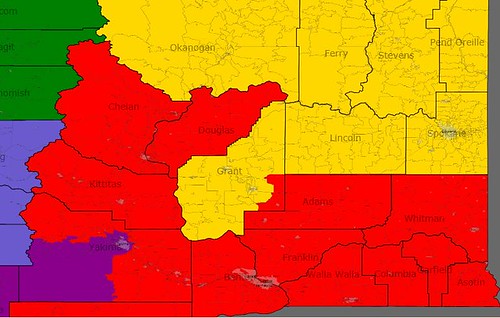
District 4 The southern portion of Eastern WA. Tri-Cities, rural Yakima County, some other counties that are no doubt very important to their residents. The Doc stays in the US House.
District 5 Spokane… and some other stuff (eastern Washingtonians will begin sending me hate mail) CMR is all set.
In summary, all the incumbents should be comfortable and the new district goes to Pierce County, the second largest in the state and to the Democrats. 6-4 is actually a little generous to the GOP but hey, Dems could have taken two more if they really wanted to. e.g. beating Reichert once in 3 tries and holding WA-3.
Of course, that’s using Version 1 of DRA, the new selection tool has tipped the scales and this is the last thing I’ll be doing with it.
think of CA for another month but no vow was made on WA. So here goes.
1st thanks for posting this map. Love those colors.
2nd I think something close to this might be adopted. Maybe Dicks gets the two coastal counties in CD8 and everything else slides around a bit.
3rd we have quite a bit of discussion of Larsen’s CD2 on an earlier thread. Basically you can keep most of the current arrangement but he does need to lose 91K. He can lose the Island counties or some of rural/suburban Shonobish county or the city of Everett. I see it as clear that he should lose Everett and yes Larsen lives just east of Everett in Lake Stevens. Looks like he is still in district. The political downside to losing Everett is that is fairly democratic. This moves takes the seat several % towards the GOP.
4th-not too concern with how 3-4-5 is sorted out. I personally would just take Walla Walla out of CD5 and then just have CD3 make a similar Yakima move but not Yakima proper. Keep Yakima in CD4.
5th New seat CD10 is about where I see it and CD8 goes several % towards the GOP while the new seat will lean strongely democratic.
I see 4 GOP seats under this map with a very competitive seat in WA2. WA was a 52-48 state in 2010 so perhaps that’s a sign this is a fair map
Give her the southern part of Yakima county rather than the city of Yakima.
One thing I notice with this is that there is no road connection between the east and west parts of the 3rd, so it’s unlikely this would pass muster. White Pass is further north in Lewis County. You could fix that by taking the eastern chunk of Lewis into the 3rd, or alternatively including Klickitat County.
It’s interesting that you put Mercer Island in the 7th, too.
Also, note that the 2008 population estimates for King County give too much to Seattle and not enough to Bellevue and other parts of the current 8th district, because Seattle grew much less than other parts of the county (and the app only county level estimates).
Anyway, fun to think about.
Rather than in WA-06?