Despite the colossal housing bust, Arizona ended the decade with a lot more people than it started with and thus earned a 9th congressional district. Here are the stats for the 8 current congressional districts. For the ethnic shares, W is Anglo, B is black, H is Hispanic, A is Asian, and N is Native American.
AZ1 (Gosar, R): 774.3k, 57.1W–1.5B–19.5H–0.9A–19.1N
AZ2 (Franks, R): 972.8k, 69.3W–3.5B–20.8H–2.5A–1.7N
AZ3 (Quayle, R): 707.9k, 70.7W–3.1B–19.3H–3.4A–1.3N
AZ4 (Pastor, D): 698.3k, 21.5W–8.6B–63.9H–2.2A–2.1N
AZ5 (Schweikert, R): 656.8k, 70.3W–3.8B–16.5H–4.4A–2.5N
AZ6 (Flake, R): 971.7k, 69.3W–3.1B–20.7H–3.6A–1.0N
AZ7 (Grijalva, D): 855.8k, 32.6W–3.7B–56.0H–1.8A–4.3N
AZ8 (Giffords, D): 754.3k, 68.2W–3.3B–22.7H–2.7A–0.8N
The target population is about 710k, so AZ2 and AZ6 will have to lose more than 25% of their people. AZ7 will also have to shed a lot, and the AZ1 and AZ8 will have to shed a little. AZ5 needs to add people. The big question: where does the new 9th go? Most of the growth was on the edges of the Phoenix area so it seems natural to put the new district somewhere on the fringe, but it isn’t immediately obvious where it should go. The southeast valley and the southwest valley both saw explosive growth, but these two areas are separated by a lot of still-empty desert. Here I show four different possibilities, but these are just four among many. M Riles just drew a plausible map that looks very different from any of these. Anyway…
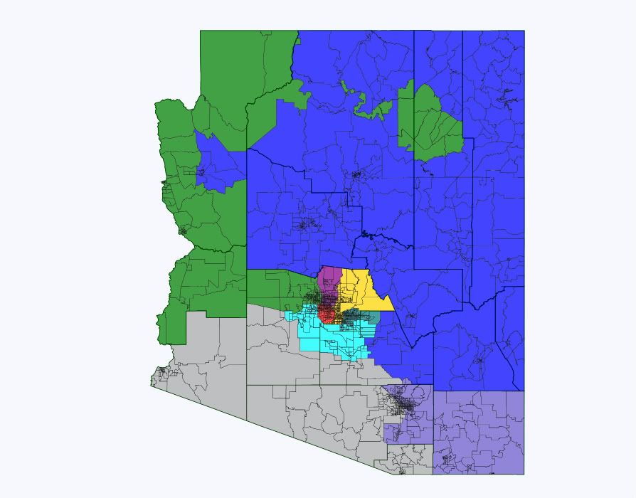
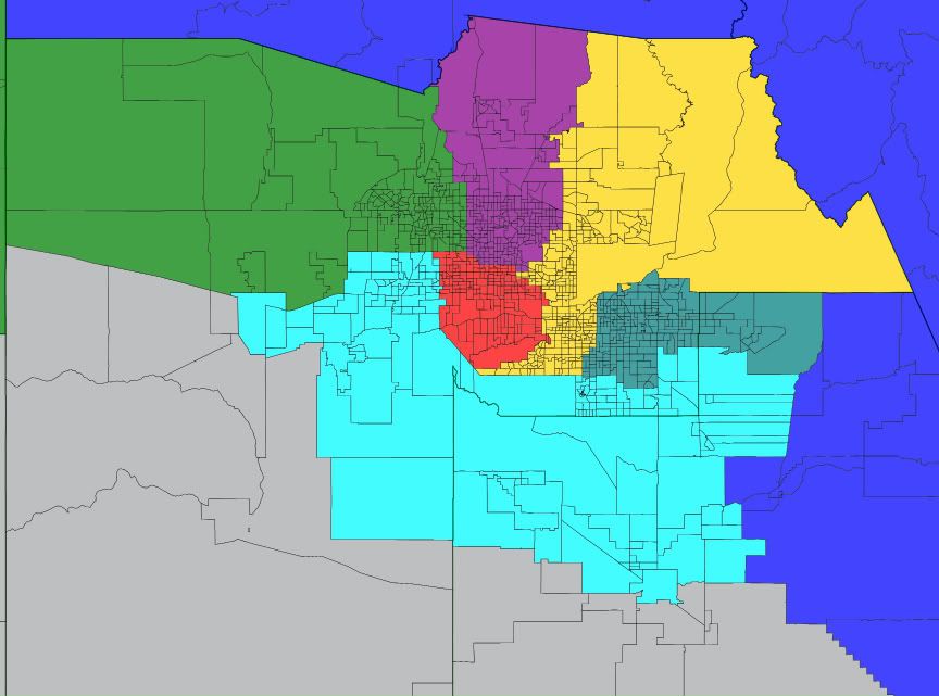
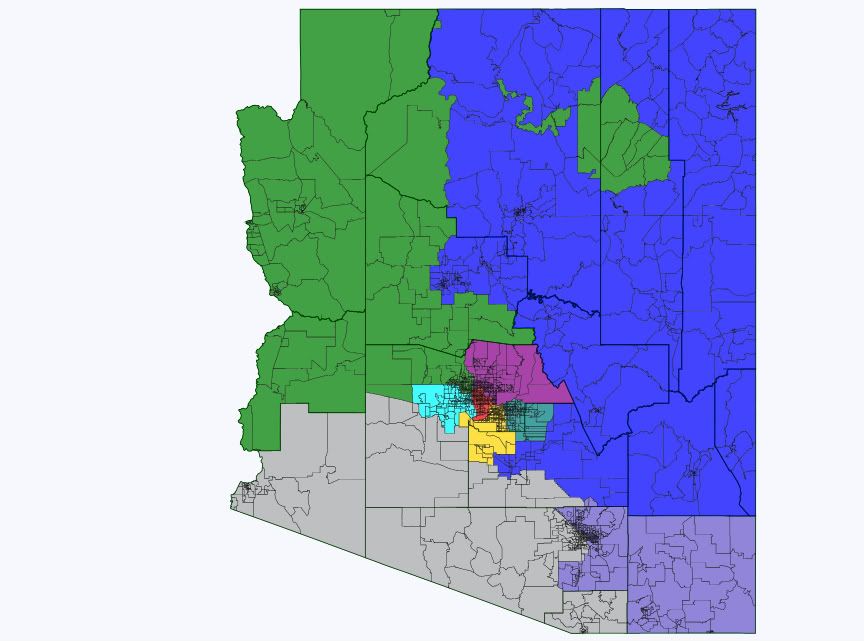
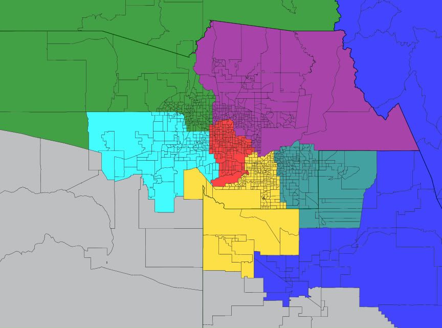
Map 1: AZ9 takes new exurbs on east and west sides
State map:
Phoenix closeup:
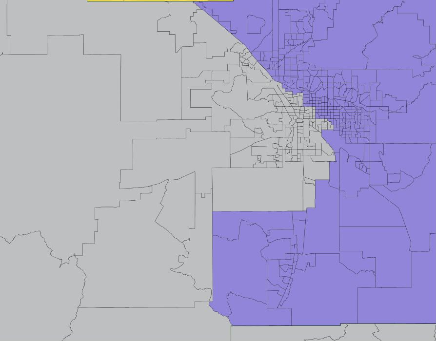
Tucson closeup (same in all 4 maps):
Here the new district is formed almost entirely from the areas of AZ2, AZ6, and AZ7 that were mostly empty 10 years ago and as such, almost every building in the state that stood 10 years ago will remain in its old district. This helps continuity, as the current reps will not have to get accustomed to new areas. A drawback: AZ9 is nice and compact but as mentioned above it has two densely populated areas separated by a lot of empty space. New ethnic numbers and notes for the districts:
AZ1 (blue): 61.0W–1.0B–15.6H–0.9A–19.9N Drops much of Pinal but retains the mining-dominated eastern parts. Picks up Kingman in Mohave county. Probably a bit more red now but still competitive.
AZ2 (green): 72.4W–2.8B–17.7H–2.4A–2.8N Picks up La Paz in all 4 maps. It’s dominated by retirees, ultra-red, and really doesn’t fit in AZ7. AZ2 is still deep red.
AZ3 (purple): 70.1W–3.2B–19.8H–3.6A–1.3N Loses part of east Phoenix to AZ5, picks up part of east Glendale from AZ2. Probably little impact.
AZ4 (red): 21.7W–8.6B–63.7H–2.4A–2.1N Negligible changes. Safe D.
AZ5 (yellow): 70.6W–3.7B–16.5H–4.5A–2.4N Probably still lean R.
AZ6 (teal): 68.8W–2.8B–22.0H–3.2A–1.1N Loses Queen Creek and south end of Gilbert and Chandler to AZ9 but retains Apache Junction which is really an extension of east Mesa. Still safe R.
AZ7 (gray): 34.0W–2.6B–56.9H–1.8A–3.3N Losing both La Paz and most of its Maricopa piece is about a wash. Drops much of Pinal where Grijalva did poorly in 2010, but picks up some reddish parts of the northwest Tucson area. That may also be about a wash overall. Slightly more Hispanic now, but also slightly more white. Still likely D.
AZ8 (blue-gray): 68.3W–3.4B–22.5H–2.8A–0.8N This district is the same in all 4 maps. I don’t expect Cochise to be broken up or thrown into AZ1 when it has historically been much more tied to Tucson. It loses its Santa Cruz piece and Pima sections west of I-10 and north of AZ-86 to AZ7. Its ethnic mix doesn’t change. Of the 15 lost Pima precincts it appears that Giffords won 4 and lost 11, so it may be slightly more blue now. Still tilt R overall.
AZ9 (toothpaste blue): 53.3W–5.6B–32.4H–3.9A–2.6N Its west valley section mostly went for Grijalva and should lean D, but its east valley piece should lean R. Overall it should be competitive, maybe tilt R. On the one hand it’s much less white than the swingy AZ1, AZ5, and AZ8, but on the other it doesn’t have a large public university like they do.
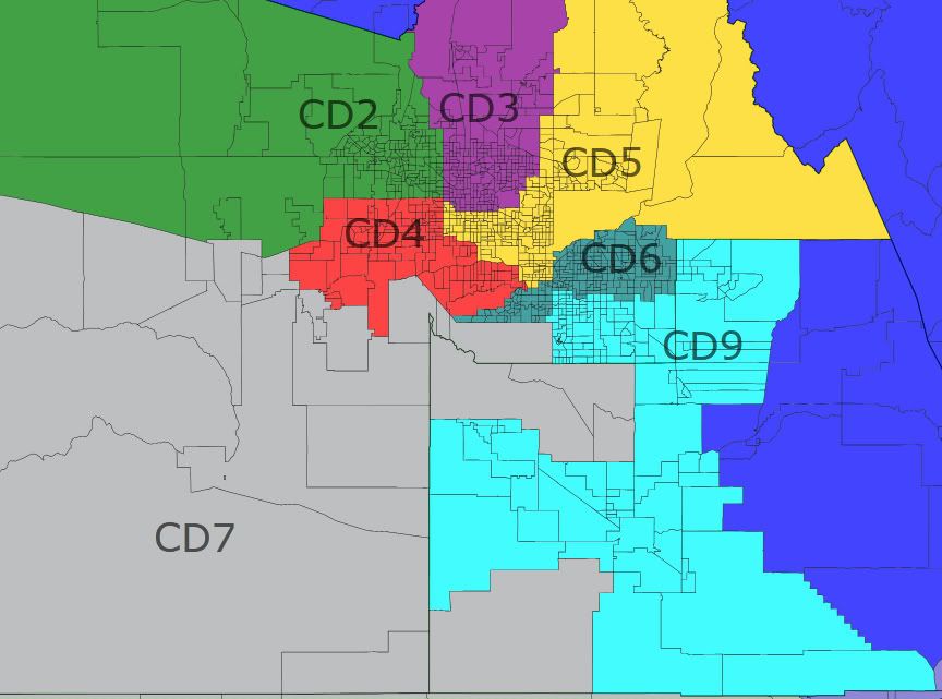
Map 2: AZ9 in the east valley
Here the new district takes most of Pinal, all of Chandler, most of Gilbert, and Queen Creek. As a result AZ6 is forced to take Ahwatukee and west Mesa from AZ5, forcing AZ5 deep into Phoenix and AZ4 out into the west valley boom areas. Unlike map 1, I think this map creates 3 clearly blue districts so it might be less likely to be adopted. It’s hard to put AZ9 entirely in the east valley without endangering AZ5 and/or AZ3.
State map not shown, as everything outside Maricopa and Pinal is the same as in map 1.
Phoenix closeup:
AZ1: 61.0W–1.0B–15.6H–0.9A–19.9N No change from map 1.
AZ2: 72.4W–2.8B–17.7H–2.4A–2.8N No change from map 1.
AZ3: 70.3W–3.2B–19.6H–3.5A–1.3N Negligible change from map 1.
AZ4: 26.7W–8.9B–58.5H–2.7A–2.4N Not quite as Hispanic now but still very blue.
AZ5: 56.0W–4.4B–31.9H–3.3A–2.5N The white population here is fairly liberal with north Tempe and the older parts of Phoenix. The district is basically Scottsdale and a bunch of blue areas, and Schweikert would probably lose to Kyrsten Sinema in 2012.
AZ6: 67.5W–3.4B–21.8H–3.6A–1.6N Still safe R.
AZ7: 33.7W–2.5B–56.4H–1.6A–4.4N Keeps the Gila River rez in this version.
AZ8: 68.3W–3.4B–22.5H–2.8A–0.8N No change from map 1.
AZ9: 64.4W–4.2B–23.1H–4.6A–1.5N Probably at least likely R, but look what happened to AZ5.
Not shown here, but it would be possible to keep both AZ5 and AZ3 red by having AZ5 take the eastern part of AZ3, which would then take the eastern part of AZ2 (and probably Trent Franks’ house). In this case the chain reaction would push AZ2 into Yavapai, forcing AZ1 to take Cochise by elimination and pushing AZ8 into the bluer parts of Pima. This would likely make AZ1 a bit more competitive, and AZ8 very unfavorable for Republicans. I don’t like this because I think Cochise and its military base belong with Tucson, not with Flagstaff. In practice this would give the Reeps the best chance at a 6-3 map, because the district that’s getting weakened the most (AZ8) is already held by an entrenched Dem.
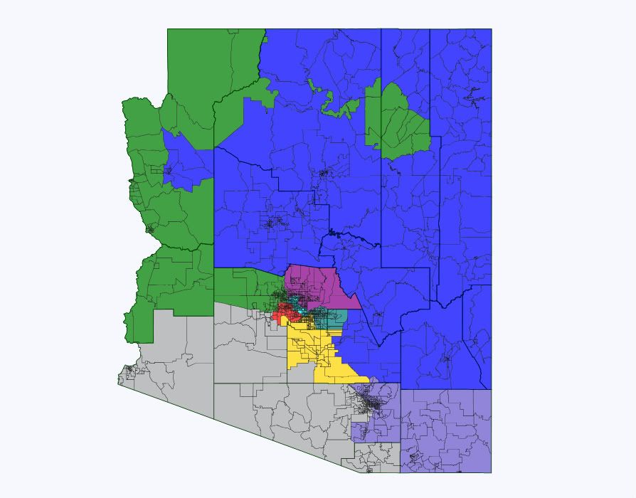
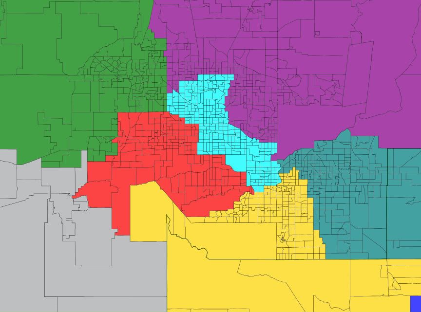
Map 3: AZ9 in the west valley
The west valley boom areas by themselves are not nearly big enough to sustain a district, so the new AZ9 pushes into AZ2 and deep into AZ4. This in turn pushes AZ3 well to the east and AZ5 deep into Pinal county. AZ2 keeps Kingman and is pushed into Yavapai, and AZ1 retains much more of Pinal here. Under this map only AZ7 would be above 50% Hispanic voting age population, but AZ4 would be at 43.4% and AZ9 at 44.7%. I doubt the Dems would object to this map: they should be favored in AZ4, AZ7, and AZ9 and the swing districts AZ1, AZ5, and (to a much lesser extent) AZ8 are all more Dem-friendly than their current versions. I didn’t try to rig this map to favor Dems, but it almost has to work out that way when you plop the new district entirely in the west valley and try to keep clean lines with communities of interest.
State map:
Phoenix closeup:
AZ1: 57.3W–1.3B–18.5H–0.9A–20.2N Loses a good chunk of Yavapai which is the real red base in AZ1. Gosar would have trouble here.
AZ2: 76.5W–2.0B–14.5H–2.3A–2.9N R+16 now?
AZ3: 78.6W–2.1B–12.6H–3.5A–1.4N Schweikert would wax Quayle in the primary here, and hold this as long as he wants.
AZ4: 35.4W–7.4B–50.4H–2.5A–2.5N Not nearly as Hispanic now but nearly as blue, as it picks up a lot of white liberals.
AZ5: 59.7W–4.9B–24.0H–5.7A–3.2N Scottsdale’s gone, replaced with swingier parts of Chandler, west Mesa, and Pinal. You want this back, Harry?
AZ6: 73.3W–2.7B–18.0H–3.0A–0.9N This is one r-e-d district.
AZ7: 34.0W–2.6B–56.9H–1.8A–3.3N Very similar to map 1.
AZ8: 68.3W–3.4B–22.5H–2.8A–0.8N No change from map 1.
AZ9: 36.9W–7.2B–49.9H–3.0A–1.0N Probably lean D to likely D. Not sure who the new rep would be, as the Dem state legislators from this area appear to have districts more liberal than the new AZ9 as a whole.
Map 4: AZ9 in the middle
The commission might just do what they did last time, and counterintuitively put the new district in the middle instead of on the fringe. The new districts last time were effectively AZ4 and AZ5. Here AZ9 ends up looking an awful lot like AZ5 from map 2, but with parts of north Phoenix and Glendale instead of Scottsdale.
State map:
Phoenix closeup:
AZ1: 61.0W–1.0B–15.6H–0.9A–19.9N No change from map 1.
AZ2: 71.1W–3.1B–18.9H–2.3A–2.8N Ho hum.
AZ3: 80.7W–1.9B–10.5H–3.7A–1.3N Pushed into Scottsdale again for Schweikert.
AZ4: 20.9W–8.9B–64.5H–2.6A–1.5N Pushed west again.
AZ5: 59.6W–4.8B–24.7H–5.4A–3.1N The reddest (Scottsdale) and bluest (north Tempe) areas are both gone, and what’s left is Ahwatukee, Chandler, south Tempe, little bits of Mesa and Gilbert, and most of Pinal. Probably still lean R, but swingy. And once again, no incumbent.
AZ6: 71.3W–2.7B–20.1H–2.8A–1.1N Safe R again.
AZ7: 34.8W–2.6B–56.4H–1.7A–3.2N Keeps more of Maricopa and less of Pinal than the other maps, which suits Grijalva just fine.
AZ8: 68.3W–3.4B–22.5H–2.8A–0.8N Still no change from map 1.
AZ9: 52.8W–5.4B–33.7H–3.4A–2.5N Don’t let the numbers fool you, this thing is blue. The white population here is mostly moderate to liberal. I suspect Pastor would run in the new AZ4 even if he lives here, so Sinema would likely hold this without too much trouble.
If the commission had to pick from these four maps, I suspect they might pick the first with its somewhat disjointed 9th district because it does the least to upset the current balance. The other three were all at least marginally favorable to Dems. I think that making the new district anything but an east-west mix will lead to this if the commission lets the other districts sort out into their most “natural” configurations, but in practice they might find it politically easier to sacrifice compactness and communities of interest a bit in order to keep the current balance of power.
