After the jump, I present a survey of maps that are demographically possible if political improbable. They are presented mostly for holiday slow-time discussion fodder. The states covered are Alabama, Kentucky, Louisiana, and Virginia. Republicans will control the process in Alabama; the Democrats control a single house of the legislature in the other three states. So the Democrats are unlikely to get maps as good as these. My redistricting instincts tend towards “good government” aesthetics, so these maps are about what’s possible with relatively compact districts.
Alabama
Top-line results: 5 R – 2 D. (Neutral year, open seat, quality candidates, my impression)
This map creates two majority-black districts in Alabama, while pushing the Huntsville-based 5th in slightly more Democratic direction.

The estimates in Dave’s App put Alabama at 4.66M people. The actual Census figure is 4.78M.
The 1st and 2nd engage in extensive territory swapping with the 2nd. The 1st gains gains the southeastern corner of the state; the 2nd gains much of Mobile proper. This roughly doubles the black percentage of the 2nd, taking it to 53% black, 43% white. Martha Roby should be in trouble. The 7th is very slightly diluted, dropping from 61% to 59% black. Making the 2nd majority black also let me shore up Mike Roger’s 3rd, which lost about 8 points off its black percentage.
In the north, the 5th needed to shrink. Glancing over the last decades worth of county-level results, the eastern side of the district seemed slightly more Democratic than the western side, so I lopped off Jackson County. Mo Brooks would probably still be fine here, but I’d rate this as the district most likely to flip to the Democrats outside of the majority-black ones.
I’m not entirely sure what the Republican will do with their control. The current 4th and 6th are R+26 and R+29 respectively, so a well-executed unpacking of those districts should end shoring up the other four GOP-held districts.
Kentucky
Top-line results: 3 R – 2 D – 1 S (Neutral year, open seat, quality candidates, my impression)
This map shores up Ben Chandler’s 6th district, while pushing the Paducah-based 1st into a potentially swingy seat. (I might be over-estimating Democratic chances there.)
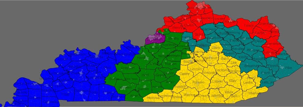
The estimates in Dave’s App put Kentucky at 4.04M people. The actual Census figure is 4.34M.
Looking at recent governor and US senator races, I noticed that the geographically largest areas of Democratic support in Kentucky is in the central portion of western eastern half of the state. That support is currently cracked into parts of three districts. I consolidated that support into Chandler’s 6th (teal), which should go from swingy to solidly Democratic.
In doing so, I forced the 5th (yellow) to the west, eating up areas that are contributing to Republican margins in the 1st (blue). (The new 5th is very Republican — it’s the only district without a single county that went Democratic in either of the last two US Senate races.) This new 1st should be winnable for a Democrat under the right circumstances — for example, by eyeballing it, I estimate that Mongiardo probably won in the 2004 Senate race.
I actually think that my 6th might have a decent shot of being created if the state House Democrats can force incumbent-protection. It’s just that the first will need to be solidified for the Republicans by some territory swaps with the 2nd and 5th.
Louisiana
Top-line results: 3 R – 2 D – 1 S. (Neutral year, open seat, quality candidates, my impression)
This map creates two majority-black districts in Louisiana, while trying to make the Shreveport-based 4th as Democratic as possible.

The estimates in Dave’s App put Louisiana at 4.41M people. The actual Census figure is 4.53M.
The 2nd (green) and 6th (teal) are the intended majority black districts. The actual figures are more like 49.6% in each. The 4th (red) is 54% white, 41% black. I hope that’s enough to make the 4th competitive for the Democrats.
Most speculation I’ve seen indicated the Republicans will be trying to make a single Baton Rouge-to-New Orleans majority-black district. Given the recent rate of party switching in the Louisiana state legislature, I imagine they’ll probably succeed.
Virginia
Top-line results: 5 D – 4 R – 2 S (Neutral year, open seat, quality candidates, my impression)
I originally presented this map in a comment in diary by drobertson. It fits the theme though, so I’m reposting it for consideration. This map is probably the most “good government” of these maps – each district basically corresponds to an existing political/cultural region of Virginia.
Its most notable feature is that presents two plurality black districts in the southeastern part of the state.

The estimates in Dave’s App put Virginia at 7.77M people. The actual Census figure is 8.00M.
1st (blue) – Peninsulas – Obama 46, McCain 54
2nd (green) – Suburban Hampton Roads – Obama 49, McCain 51
3rd (purple) – Urban Hampton Roads – Obama 69, McCain 31 — VRA: 49% black, 42% white
4th (red) – Richmond, Petersburg, and South Virginia – Obama 61, McCain 39 — VRA: 50% black, 44% white
5th (yellow) – Piedmont – Obama 47, McCain 53
6th (teal) – Shenandoah – Obama 43, McCain 57
7th (grey) – Richmond suburbs – Obama 42, McCain 58
8th (slate blue) – Arlington, Alexandria, north Fairfax- safe D
9th (cyan) – southwest Virginia – Obama 40, McCain 60
10th (magenta) – Prince William and Loudoun – Obama 56, McCain 44
11th (lime) — south Fairfax and Manassas – ???
The presidential percentages are back-of-the-envelope style. I used the 2008 figures to the nearest hundred and counted split cities/counties as if they were wholly within the district they were most in. I didn’t feel like delving into Fairfax precincts for the 8th/11th. The 8th should be just as safe as it is now, and I think, though I’m not 100% certain, that this version of the 11th is more Democratic than the current one. (Drobertson questioned this assertion at the time I made it, but agreed that this new district ought to be better for Gerry Connolly if not Generic D.)
The 2nd is more Republican than listed, but I don’t know how much more. I counted Isle of Wight and Suffolk as if they are wholly in it, but they are both donating their most heavily black precincts to the neighboring 4th and 3rd, respectively.
There’s a similar dynamic for the 4th and 7th, which are probably even more firmly in their respective parties’ control than it appears. I counted all of Richmond and Henrico in the 4th, but the majority white parts of each are actually in the 7th.
Notes on incumbents: Wittman, Scott, Cantor, Goodlatte, Moran, and Connolley are all fine. Rigell and Forbes would share the 2nd. Hurt lives in the new 4th. Griffith lives in the new 6th. Wolf lives in the new 8th. I assume all three of them would continue to run in the same districts anyway — all of them are in counties adjacent to their districts.
In the real world, the Virginia state senate Democrats should be able to force incumbent-protection, but seperating Richmond from Hampton Roads for two black opportunity districts won’t be happening.
a dem running for Congress about 35-40% of the vote. Thats how racially polarized that part of the state is.
The KY map reminds of the 1991 map that the democrats produced. At the time the GOP was holding three seats (Cumberland plateau-Faytteville seat plus Northern KY/louisville suburbs) while the democrats held the other 4.
The Map they the democrats drew a Map that looked alot like 6-0 as Hal Rogers was merged with young Carl Perkins (no blue suede shoes please) plus Gopers Hopkins and Bunning were weakened.
As it happened KY’s 6-0 democratic plan nearly turned 6-0 republican. A bridge too far indeed.
I did have one question. There are November state senate elections in 2011 in VA. I know the state needs to do legislative lines but can congressional redistricting be postponed in VA?
They at least have a seat at the table, which means he’s probably secure.
With Louisiana losing a seat, there might be a push for another VRA seat. Louisiana did have another VRA seat before, but lost it, so an opportunity might be seen here.
I like the idea of making the former Perriello district go from Charlottesville to Fauquier. Here is my best-case Virginia for Democrats.

This map is potentially a 9-2. The 4 southeastern districts are each 54%-58% Obama.
with rural counties that are quickly trending Republican, than with his current suburban counties that might trend more Democratic?
the Obama DOJ can’t “force” states like VA to have 2 black-majority districts … I drew a map myself for VA last month but never posted b/c I was afraid it was unlikely in real life …
the yellow dist. is 52% black – 42% white
the dark green one in Hampton Roads is 51 black – 41 white
all the other ones are drawn to protect/strengthen the GOP and Dem. incumbents …
it’s crazy that out of 11 VA disricts, only 1 is majority black ..
is still fairly Democratic, it voted 44% for Sparks which is two points over the statewide average and it voted for Gore. You’d need to take out white suburbs/exurbs of Huntsville to make the district more favorable to a blue dog. Not that it matters but just a thought.
Suburbs in the deep South will never, ever, ever vote for a Democrat. Ever. Unless they’re filled with minorities and transplants or they’re becoming culturally different. (Nashville, Atlanta, Raleigh etc) Traditional Democratic, poor rural areas might in the right circumstances if the candidate is a good old boy and the Republican is a city slicka. This happened in NC between Purdue and McCrory. Purdue absolutely demolished McCrory in rural areas, while McCrory almost won Mecklenburg County. Strange election results for modern times.