It’s officially redistricting season, and I wanted to take a look at how the 435-member cap that the House of Representatives imposed on itself in 1911 affects overall membership. Most districts in the USA have a population between 625,000 and 675,000, as a result of apportionment of districts between states. Yet apportionment–and therefore, district population–cannot be fully equal so long as the current rules stand, because the Constitution mandates that each state have at least one district of its own. That means that Wyoming, the smallest state, gets WY-AL, which has an estimated population of 544,000–that is, about 100,000 fewer people than the average CD.
In response to this inequality–a vote for Congress in Wyoming means comparatively more than a vote for Congress in other states–some folks have proposed a “Wyoming Rule” that would toss out the cap and make district sizes equal to the population of the smallest state. That is, each district would have 544,000 people.
I decided to test out the “Wyoming Rule” on the state where it would have the greatest effect: California, which would gain 16 new districts as a result of the overall reduction in district size. Below is one way that California could be drawn with 69 districts. I did a little bit of everything here: gerrymandered to protect incumbent parties (not incumbents themselves), tried to create as many VRA districts as possible, and sought to keep counties intact in the cases where partisan or racial numbers wouldn’t be affected.
Northern California:
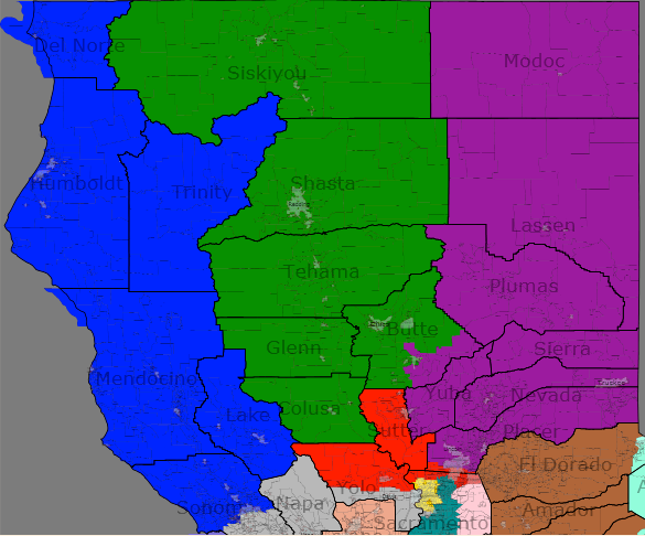
CA-01 (blue): OPEN, 77% White, D+15, Obama 67%
–This North Coast district pulls fully out of the Bay Area. I would expect Mike Thompson to move north and run.
CA-02 (green): Wally Herger (R), 80% White, R+10 McCain 55%
–Not much has changed from Herger’s current district. The loss of the southernmost portion of the district has shifted the PVI slightly to the left.
CA-03 (purple): Tom McClintock (R), 81% White, R+9, McCain 54%
–The only district to border both Oregon and Nevada, the 3rd contains some of the most conservative areas of California offset somewhat by liberal towns in the Sierra Nevada. McClintock is safe in this exurban/rural hybrid.
CA-04 (red): Dan Lungren (R), 70% White, R+8, McCain 52%.
–Lungren’s new district pulls out of the Sierra Nevada and now includes Sutter County and part of Yolo. The base remains in the northern Sacramento suburbs, and the district has flipped from Obama to McCain.
Sacramento and the North Bay:
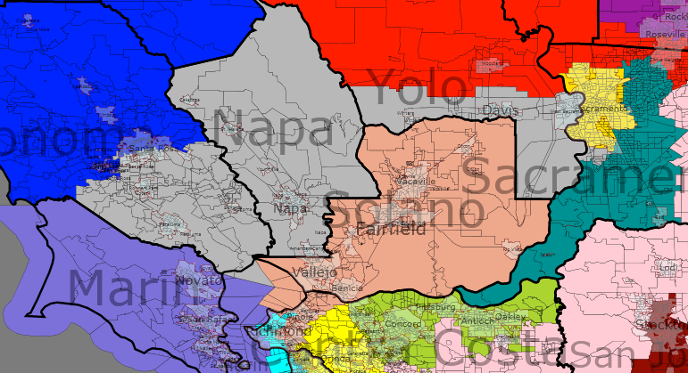
CA-05 (yellow): Doris Matsui (D), 42% White, 22% Hispanic, 16% Asian, D+19, Obama 72%
–Almost entirely co-terminous with the City of Sacramento. This is the first of many, many majority-minority districts on the map and is safe for Matsui.
CA-06 (teal green): John Garamendi (D), 65% White, D+1, Obama 55%.
–The eastern and souther suburbs of Sacramento County give us our first tossup, which is slightly D-leaning but appears to have voted for Bush in 2004. Most of this is currently Lungren’s territory, and he could probably win here, but he would prefer to run in my 4th. Garamendi, on the other hand, does live here, but might choose to run in the 13th.
CA-07 (grey): Lynn Woolsey vs. Mike Thompson (D), 68% White, D+17, Obama 71%.
–This is basically Wine Country plus some western suburbs of Sacramento. Thompson’s inconvenient choice of residence puts him here along with Woolsey, who is from the population base in Sonoma County. As I said above, Thompson would probably run in CA-01 to the north.
CA-08 (lilac): Nancy Pelosi (D), 65% White, D+36, Obama 80%.
–The new 8th crosses the Golden Gate Bridge from Marin County into the wealthy and cosmopolitan northern neighborhoods of San Francisco, including the outgoing Speaker’s Pacific Heights. Pelosi should have no problem appealing to liberal Marin, although there is another San Francisco district that she could choose to run in if she’d rather not cross the bay.
CA-13 (peach): OPEN, 47% White, 17% Hispanic, 16% Asian, 15% Black. D+14, Obama 68%.
–Solano County with a sliver of Contra Costa to make the population match. John Garamendi represents much of this now but lives just to the east in southern Sacramento County. He may well choose to run here rather than in the tossupy 6th.
Bay Area
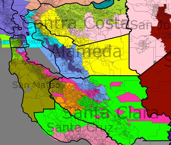
CA-09 (cyan): Barbara Lee (D), 37% Black, 21% Hispanic, 20% White, 17% Asian. D+36, Obama 89%.
–Now this is where the Wyoming Rule gets fun! Smaller districts allow you to draw VRA districts where you previously could not, because the population thresholds are lower. For example, this district is a new plurality-black district in the Bay Area. It combines Oakland in Alameda County with Richmond in Contra Costa and a small portion of heavily-black southeastern San Francisco. CBC chairwoman Barbara Lee will love it.
CA-10 (magenta): OPEN, 52% Hispanic, 21% Asian. D+28, Obama 81%.
–Here’s a new, heavily gerrymandered Hispanic-majority district in the West Bay. The 10th is a thin strip that hugs the bay coast, connecting parts of San Francisco with Hispanic neighborhoods in San Jose, along with certain Hispanic pockets in Daly City and Palo Alto. I’m pretty sure this would be a wide-open Democratic primary, probably favoring a Hispanic from San Jose.
CA-11 (lighter green): OPEN, 43% White, 34% Asian. D+29, Obama 82%.
–Southern San Francisco and northern San Mateo combine to form another ultra-blue open seat (assuming Pelosi runs in the 8th.) It is very telling that despite three VRA seats in the Bay Area, this “leftovers” district is still majority-minority. Much of the SF city council would be interested in the primary here, and an LGBT representative would make sense given the area.
CA-12 (periwinkle): Mike Honda (D), 50% Asian, 25% White, 17% Hispanic. D+15, Obama 70%.
–More VRA fun, as we can now draw an Asian-majority district in the Bay. Anchored in eastern San Jose, the district picks up heavily Asian precincts in Fremont and Union City (Alameda County) before jumping across the Bay into southern San Francisco. I don’t know if Mike Honda lives within the lines, but I obviously drew this with him in mind.
CA-14 (brown/green): Jackie Speier (D), 68% White. D+18, Obama 73%.
–Speier sheds her part of San Francisco (and a few PVI points in the process) and now has a San-Mateo centered district with a small part of Santa Clara. This is the heart of Silicon Valley and home to Stanford.
CA-15 (orange): Anna Eshoo (D), 53% White, 28% Asian. D+15, Obama 70%.
–This is intended to be Eshoo’s district, although she will have to move slightly south if she wants to live in it (why, Cali Dems, must you live so close to each other?) Essentially, these are the northern and western suburbs of San Jose plus a portion of the city itself.
CA-16 (bright green): Zoe Lofgren (D), 59% White, 21% Hispanic. D+13, Obama 67%
–Lofgren gets the San Jose leftovers, plus southern Santa Clara and a largely unpopulated part of Santa Cruz. Here district is a few points less Democratic than before but nowhere near the point where she needs to be worried.
CA-17 (deep purple): Pete Stark (D), 37% White, 28% Hispanic, 20% Asian. D+20, Obama 75%
–Yet another super-Democratic stronghold, this time in Alameda County. Stark is safe in this district that is majority-minority by accident (that is, this is what was left over after drawing 3 VRA districts, and it’s still less than 40% White.)
CA-18 (yellow): Jerry McNerney (D), 73% White. D+18, Obama 73%
–Jerry McNerney is rewarded for holding down a tough district in 2010 with the greatest gift you can give a Democrat: Berkeley. Also takes in McNerney’s home base of eastern Alameda and a slice of Contra Costa.
CA-19 (olive): George Miller (D), 61% White, D+13, Obama 67%
–No, I didn’t forget about Miller…..I just dropped his district number from 7 to 19. He is plenty safe in this surprisingly small district in northern Contra Costa County. This area looks like a wonderful place to live, by the way.
Central California
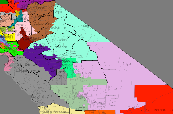
CA-20 (pink): OPEN, 65% White, R+6, McCain 52%
–This is a more Republican version of the current CA-11, covering much of San Joaquin, southern Contra Costa, and part of unincorperated Sacramento. David Harmer would run here if he ends up being declared the winner after the recount in CA-11, and he might anyway even in he loses. It’s not a certain win, especially with Obama on the ballot, but the Republicans would be favored here.
CA-21 (maroon): OPEN, 40% Hispanic, 37% White. D+8, Obama 62%
–A Hispanic plurality district including Stockton and western Stanislaus County. Dennis Cardoza does not live here but may run. Republicans won’t compete here until they learn how to better appeal to Hispanics.
CA-22 (brown): OPEN, 78% White, R+10, McCain 54%
–This district is centered in Modesto and runs to the northeast, picking up several conservative counties in the Sierra Nevada. No incumbent lives here, but a Republican would almost certainly win here.
CA-23 (aqua blue): Jeff Denham (R), 64% White, 22% Hispanic, R+10, McCain 54%
–Almost identical to its northern neighbor, the 23rd is based in Fresno and includes the rural, beautiful Yosemite Valley. Newly-elected Rep. Denham will cruise here.
CA-24 (purple): Jim Costa (D), Dennis Cardoza (D), 59% Hispanic, D+9, Obama 63%
–The trouble with the Wyoming Rule is that VRA districts don’t have to be as stretchy as they normally do. With four plurality-Hispanic districts in the Central Valley now, Costa and Cardoza are unfortunately both stuck in this one. Most of the population comes from Fresno, which would favor Costa.
CA-25 (salmon): Sam Farr (D), 52% White, 35% Hispanic, D+19, Obama 74%
–We jump back to the coast now and find a safe seat for Farr around the Monterey Bay. Surprisingly, the district is over a third Hispanic.
CA-26 (darker grey): OPEN, 58% White, 32% Hispanic, R+1, Obama 53%
–Every good map has at least one pure tossup, and this Central Coast seat is as evenly divided as they come. Democratic Monterey, slightly Democratic San Benito, heavily Republican Kings, and swingy San Luis Obispo combined to vote right at the national average in 2008, although this district voted more Republican than the nation in 2000 and 2004. California is trending Democratic, but Republicans hold most seats like this one for now. I’m sure that both sides would put up strong candidates for this one year in and year out.
CA-27 (electric green): Devin Nunes (R), 45% Hispanic, 43% White, R+9, McCain 53%
–Returning to the Central Valley, we find Nunes losing a few points off his PVI but still looking good in a Hispanic-plurality district south of Fresno. Low Hispanic participation and very conservative white voters keep this district in the Republican column.
CA-28 (pinkish purple): Kevin McCarthy (R), 65% White, R+19, McCain 65%
–By far the most Republican district in California, the dark-red 28th is based in Bakersfield (Kern County) and runs all the way to the Nevada border, picking up mountain and desert areas as well as the leftovers of Tulare County. McCarthy is safe for a long, long time.
CA-29 (earthy green): OPEN, 56% Hispanic, R+4, Obama 50%
–We round out our tour of the Central Valley with another swing seat that leans slightly Republican despite its status as a VRA Hispanic-majority seat. Many of the Hispanics are non-citizens who work the fields of this agricultural region, and the white voters in Bakersfield give the GOP the slight edge here. This would be an intriguing open-seat race in 2012.
West of Los Angeles
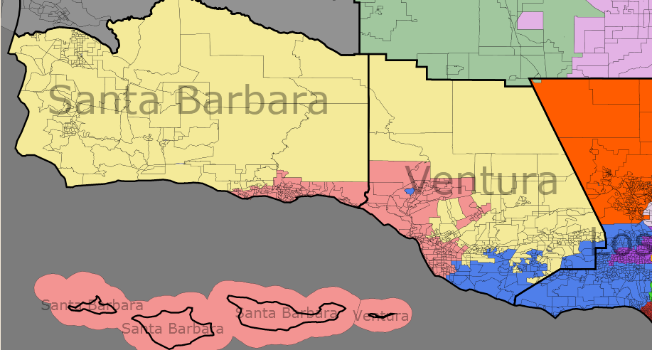
CA-30 (peach): Lois Capps (D), 46% White, 44% Hispanic, D+15, Obama 69%
–The sweetheart gerrymander lives on! Capps gets to keep her coastal Democratic district, but the Wyoming rule allows this district to shrink to just Santa Barbara and Oxnard.
CA-31 (pale yellow): Elton Gallegly (R), 63% White, R+5, 50% McCain
–Gallegly will always be Capps’ (electoral) sweetheart, and can thank her because he basically gets to keep the district he has now. Inland Santa Barbara and Ventura lean slightly Republican, and that should be good enough to keep the sun from going down on Elton, unless the Democrats get serious about recruiting in districts like these.
CA-33 (royal blue): Henry Waxman (D), 74% White, D+6, Obama 60%
–We’ve arrived! The first of many districts to take in part of Los Angeles, the 33rd starts in Thousand Oaks in Ventura, grabs Malibu, and ends up in the mostly residential far western reaches of LA. Waxman’s PVI is not nearly as robust as his old one, but he should hold on just fine.
Los Angeles County
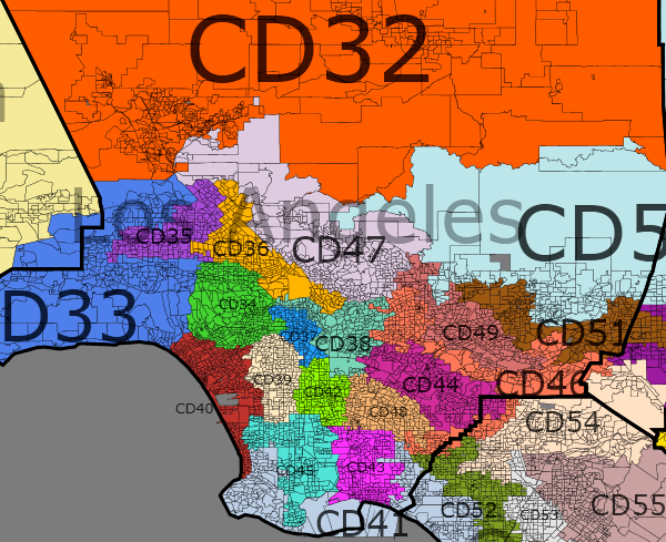
I’ve labeled the districts on the map so you can tell which one is which (they’re all kind of small, and they don’t quite go in numerical order because I wanted to keep similar colors away from each other.)
CA-32 (red-orange): Buck McKeown (R), 57% White, R+6, McCain 49%
–This includes the entire northern half of the county, including the part cropped out of the image (more or less everything north of the San Gabriel Mountains.) McKeown drops the sprawling desert portion of the district but surprisingly, his partisan numbers actually improve. Who would’ve known?
CA-34 (Irish green): Howard Berman (D), 69% White, D+22, Obama 76%
–Bright lights! Big Stars! The place where dreams are realized! It’s Hollywood, and it belongs to Berman. This is the last white-majority district we’ll be seeing in quite some time. Swanky Beverly Hills is also in the 34th, so you can pick your favorite actor or actress to succeed Berman.
CA-35 (Laker purple): OPEN, 55% Hispanic, D+16, 70% Obama
–A new Hispanic-majority district in northwestern Los Angeles. Yes, Los Angeles is going to produce a LOT of Hispanic-majority districts.
CA-36 (yellow-orange): Brad Sherman (D), 58% Hispanic, D+20, 74% Obama
–Sherman’s district is now Hispanic-majority as well, which could make him vulnerable to a primary challenge. However, his current district is majority-minority, and he seems pretty well liked by the base. The 36th includes Burbank and the area north of downtown LA.
CA-37 (Dodger blue): Xavier Becerra (D), 65% Hispanic, D+26, Obama 80%
–One of the smallest and most densely populated districts in the country, the 37th is comprised of Downtown Los Angeles and is home to the Dodgers, Lakers, Clippers, and Kings. It has a Hispanic supermajority, and along with the 35th is one of two districts fully within the City of Los Angeles.
CA-38 (pale green): Lucille Roybal-Allard (D), 67% Hispanic, D+28, Obama 82%
–Who? Yeah, Lucille Roybal-Allard, who has actually been around for 18 years now but keeps a rather low profile, especially compared to some of the other Los Angeles Democrats. Anyway, LRA is safe in East LA, in a district so Hispanic it almost violates the VRA.
CA-39 (off-white): Karen Bass (D), 52% Black, 39% Hispanic, D+39, Obama 93%
–This Inglewood and LA district is distinctive for two reasons. First of all, it’s the most Democratic in California and probably one of the three most Democratic in the nation (along with the Harlem and Bronx districts in NYC.) Second of all, it is the only black-majority seat out of the 69, and it may no longer be possible to draw a black-majority seat except under the Wyoming Rule. California still has a significant black population, but most of the state’s African-Americans live in areas that are even more heavily populated by Hispanics. Bonus: this district is 3% white. Wow.
CA-40 (maroon): Jane Harman (D), 54% White, D+19, Obama 73%
–Stretching from Santa Monica to Redondo Beach, this district in south-central LA county is one of the few white-majority areas around. Nevertheless, it has a strong Democratic majority and Harman needs only worry about the primary.
CA-41 (white/grey): Dana Rohrabacher (R), 64% White, R+6, McCain 50%
–The token Republican district in LA County south of the San Gabriels, the 41st is similar to Dana’s current district, starting in Torrance and hugging the coast until it reaches dark-red Huntington Beach in Orange County.
CA-42 (lime green): Maxine Waters (D), 73% Hispanic, 24% Black, D+38, Obama 92%
–One of the most Hispanic and Democratic districts in the country, the new 42nd is made up of the troubled neighborhoods of Watts and Compton. Maxine Waters is the ethically-plagued incumbent, although I would expect her to get a strong Hispanic primary challenger.
CA-43 (bright magenta): Laura Richardson (D), 41% Hispanic, 25% White, 16% Black, D+ 19, Obama 73%
–Long Beach is another area in need of a cleaner Representative, but for now, Laura Richardson will represent this coalition district.
CA-44 (red-violet): Grace Napolitano (D), 68% Hispanic, D+10, Obama 64%
–We’re into the eastern suburbs of Los Angeles now, and Napolitano’s PVI has dropped a little bit (it was D+18). The congresswoman is safe, however, in the heavily Hispanic cities of Whittier, Montebello, Pico Rivera, and her hometown of Norwalk.
CA-45 (sky blue): OPEN, 42% Hispanic, 24% White, 16% Asian, 15% Black, D+15, Obama 69%
–The Port of Los Angeles is one of the most important shipping centers in America, and its next representative could conceivably be of any race in this wide-open coalition district. Carson is also included in this Democratic stronghold.
CA-46 (burnt orange): Judy Chu (D) vs Gary Miller (R), 51% Asian, D+2, Obama 56%
–The wishbone-shaped 46th, to the northeast of Los Angeles, is probably my favorite district on the map. It is Asian-majority, and surprisingly, a true swing district that George Bush narrowly carried and Barack Obama decisively won. Chu’s home city of Monterey Park, is at the tail end of the northern fork, Walnut and Diamond Bar in the Inland Empire make up the central core of the district, and Cerritos is the southernmost point. Chu is not safe here, but she makes sense for the time being. Miller lives in the eastern part of the district and could conceivably defeat Chu with a good campaign, but it would be a tough fight for him.
CA-47 (light lavender): Adam Schiff (D), 47% White, 27% Hispanic, 18% Asian, D+11, Obama 66%
–I moved back north of LA to draw the 47th in Pasadena and Glendale. These are fairly reliably Democratic suburbs, and they are combined with some leftover Hispanic precincts in LA itself to make this district safe for Schiff. Once again, this is a majority-minority seat.
CA-48 (tan): Linda Sanchez (D), 71% Hispanic, D+19, Obama 74%
–One final urban district in East LA, also with a Hispanic supermajority. Linda Sanchez lives just outside the district (her hometown of Lakewood is in Rohrabacher’s GOP-leaning 41st), but she represented a good chucnk of this area before and would fit in perfectly here.
CA-49 (terra cotta clay red): OPEN, 60% Hispanic, D+13 67% Obama
–A new Hispanic-majority district in the San Gabriel Valley, this looks somewhat like Hilda Solis’ old stomping grounds. The major centers of population are El Monte, Baldwin Park, and La Puente.
CA-51 (chocolate brown): OPEN, 56% Hispanic, D+11, Obama 65%
–Another new Hispanic-majority district in the San Gabriel Valley. This is the slightly-less Democratic northern twin of the 49th, anchored in Pomona, and is also an open seat. Hispanic Democrats would have plenty of primaries to choose from if this map were to be enacted.
Orange County
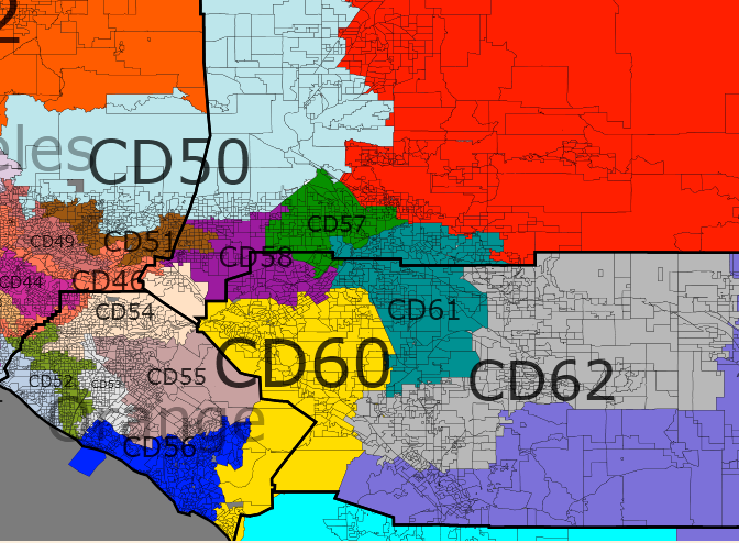
CA-50 (pale blue): David Drier (R), 58% White, R+7, 52% McCain
–No, this district isn’t anywhere near Orange County, but it has to be written up somewhere. The well-dressed Rules Chairman gets a better district for his electoral future in the northeastern corner of Los Angeles County and rural western San Bernardino. Drier probably wishes this plan would be enacted, because his current district is vulnerable to being ripped apart.
CA-52 (forest green): OPEN, 43% White, 27% Hispanic, 25% Asian, R+6, 51% McCain
–If Democrats really think Orange County is trending their way, they’ll have to prove it by winning districts like this one, which runs from Cypress through Garden Grove and Fountain Valley and ends up in Huntington Beach. This would start out as Lean R in a neutral year, and you could see a Vietnamese Republican run against a Hispanic Democrat. One thing about California that has surprised me is that Republicans are competitive in many majority-minority districts.
CA-53 (almost white): Loretta Sanchez (D), 66% Hispanic, D+10, Obama 66%
–Sanchez’s district sees little change in racial figures but does get a healthy jump in PVI to protect the congresswoman against future challenges. It is based in Santa Ana with tendrils into Irvine and Anaheim.
CA-54 (light beige): Ed Royce (R), 49% White, 32% Hispanic, R+8, McCain 53%
–Don’t be deceived, this district is very Republican, with Obama’s exceptionally strong performance lowering the PVI somewhat. Anaheim, Yorba Linda (Nixon’s birthplace) and Royce’s home city of Fullerton are the key players. I believe Mickey Mouse is a constituent, although he and the rest of Disneyland may be in the 53rd as well. You may see Gary Miller make a run at this one instead of challenging Chu, but the primary geography would favor Royce.
CA-55 (darker purple/brown): John Campbell (R), 60% White, R+6, McCain 51%
–Cambell moves inland and in the process gets a McCain district instead of his slight Obama district. The giant suburbs of Orange and Irvine make up the vast majority of this one.
CA-56 (blue): OPEN, 78% white, R+9, McCain 54%
–The most Republican district in Orange County is an open seat that stretches from Newport Beach to San Clemente, and then inland to Santa Margarita. Gary Miller represented a small portion of the 56th but would have to move about 50 miles to make a run. More likely, there would be a competitve primary that would favor a Laguna-area Republican.
CA-58 (purple): OPEN, 44% Hispanic, 40% White, D+2, Obama 57%
–I can’t figure out whether this new district may have just barely voted for Bush in ’04, but it certainly leans Democratic. The largest city in the district is Ontario; it also has Chino and part of Riverside. You would probably see a Hispanic Democrat and a white Republican face off here, favoring the Democrat in presidential years but a tossup in a good GOP year like 2010.
CA-60 (yellow): Ken Calvert (R), 53% White, 31% Hispanic, R+6, McCain 51%
–This is mostly a Riverside district but I’m covering it here because it crosses the Santa Ana Mountains to take in the easternmost part of the OC. Calvert, like many of his GOP colleagues, now has a district McCain won, in this case centered on his home city of Corona.
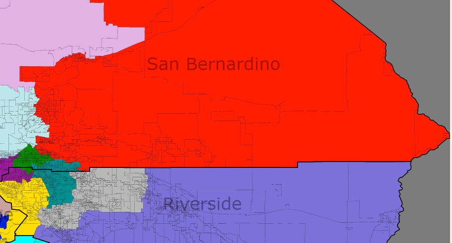
Inland Empire
CA-57 (green); Joe Baca (D), 60% Hispanic, D+16, Obama 70%
–A Hispanic-majority district in San Bernardino County, centered on the county’s namesake city. Baca is safe.
CA-59 (red): Jerry Lewis (R), 60% White, R+10, McCain 54%
–This massive district takes up most of San Bernardino County, but a lot of that is desert. The population comes from the city of San Bernardino and the suburb of Highland, and there are a few lonely Mojave outposts like Barstow in the mix too. Lewis actually lives just outside the district in my new 61st, but he’d be most comfortable here.
CA-61 (teal green): OPEN, 42% White, 35% Hispanic, 12% Black, D+2, Obama 56%
–This southern SB/northern Riverside district is trending Democratic and would probably favor a Democrat from Moreno Valley or Loma Linda in a presidential year. Certainly not an area the Republicans are ready to give up on though.
CA-62 (grey): OPEN, 66% White, R+8, McCain 53%
–This longtime GOP stronghold in central Riverside County has trended Democratic as well, but is still fairly safe territory for Republicans for the foreseeable future. Hemet and San Jacinto are the nucleus of the district.
CA-63 (lilac): Mary Bono Mack (R), 51% White, 41% Hispanic, R+6, McCain 51%
–Republicans will want Bono Mack to run here instead of the safer 62nd. Her home city of Palm Springs is split between the two districts, but it is the heart and soul of the 63rd and an outlier of the 62nd. Like Bono Mack’s current constituency, it runs all the way to the Arizona border and leans Republican in a normal cycle.
San Diego
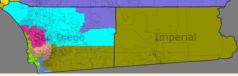
CA-64 (cyan): Darrell Issa (R), 57% White, R+11, McCain 55%
–We’re almost there. This is the safest seat for the GOP in Southern California. The investigation king takes in some wealthy areas along the coast north of San Diego, along with the very conservative inland part of the county.
CA-65 (magenta): Brian Bilbray (R), 65% White, R+6, 50% McCain
–More wealthy towns north of San Diego that historically vote Republican. Obama ran strongly here, but Bilbray is probably safe for the next decade.
CA-66 (electric green): Susan Davis (D), 68% White, D+13, Obama 67%
–Davis gets the white liberals along the coast, centered in San Diego and running north to Encinitas and south to Imperial Beach and the Mexican border. The Pacific Fleet of the US Navy is headquartered in this district.
CA-67 (pale blue): Bob Filner (D), 56% Hispanic, D+14, Obama 68%
–Enough of that silly tail to Imperial County! Filner now has a compact, Hispanic-majority district made up of South San Diego and Chula Vista. The busiest border crossing station in the state is here, so immigration must be a hot topic among the constituents.
CA-68 (peach): OPEN, 65% White, R+1, Obama 53%
–One final open seat, and one final tossup. The fightin’ 68th is home to the majority of the City of San Diego and is comfortable voting for either party (although it was historically very Republican.) Expect a great fight here in 2012.
CA-69 (green/brown): Duncan Hunter (R), 43% White, 38% Hispanic, R+5, McCain 50%
–The final district in the state can be summed up in one word: leftovers. More accurately, these are the very Republican suburbs and exurbs of San Diego and the Democratic bastion of Imperial County, which doesn’t really fit anywhere in SoCal (it belongs with the Central Valley.) The San Diego County portion of the district is more populous, hence the Republican lean. And oh yeah, lots of the Mexican Border.
Current Map
34 Democrats, 19 Republicans
25 White majority, 9 Hispanic majority, 13 White plurality, 6 Hispanic plurality
0 Black plurality, 0 Asian plurality
Wyoming Rule Map
44 Democrats, 25 Republicans (giving 6, 26, 46, and 61 to the D’s, 29 and 68 to the R’s.)
35 White majority, 15 Hispanic majority, 2 Asian majority, 1 Black majority, 10 White plurality, 5 Hispanic plurality
So what did my incumbent-party-protection Wyoming Rule map create? Well, it did its job–the new delegation is expected to be made up of 64% Democrats, just like the old one! The most notable accomplishment was eliminating the “Obama Republican” districts; that is, the 8 districts located mainly in SoCal that voted for President Obama but sent a Republican to Congress. All eight of those Republicans now have a McCain district, with Buck McKeown having the most tenuous hold of any of them. Previously there had also been three “Bush Democrat” districts, whereas now there is one: Judy Chu’s CA-46, and only because I saw no other way to make that district majority-Asian. There are also six open seats that can be considered competitive for 2012.
My other goal was to create as many VRA districts as possible. Sure, I had to create 7 new white-majority districts, but that’s to be expected when you need to make 16 new districts overall. Hispanics are big winners with this map, as they gain five new VRA majority seats and also upgrade one of their plurality seats to a full majority. African-Americans now have a majority seat in Inglewood and a plurality seat in Oakland. Finally, the Wyoming Rule creates the first two Asian-majority districts outside Hawaii, one in the Bay Area and one in Greater LA.
This exercise has proven to me firsthand that California is a ticking time bomb for Republicans. The “average” Democratic district on my map gave about two thirds of the vote to President Obama–in other words, a very safe blue seat. On the other hand, the “average” Republican district gave about 54% of the vote to John McCain, rendering many of the red seats vulnerable if California continues its Democratic trend. If there’s any consolation for Republicans, the are competitive in a surprising number of majority-minority seats, which is uncommon outside of California. However, they will need to do much better with minority voters, particularly Hispanics, if they are to make any serious comeback in the state.
Thanks for making it all the way through. As always, I appreciate and enjoy your feedback.
Smaller districts are always better for democracy, but more seats means more politicians and no one wants more of them, so it’s a rock and a hard place.
There are a lot of districts here that are close to what Assembly districts look like, which have an average of about 425k residents currently. The map look almost parliamentary, lots of areas have their own seat and could very well be named constituencies.
I am thinking of a hypothetical 120-district gerrymander with the Senate and Assembly merged into one legislative house.
at least 150 State Representatives (change the name from Assembly, to the California House of Representatives, no one really uses “Assembly”), and 62 Senators (like New York has) to accomodate the large population. Yes there’ll be more politicians but more reasonable district sizes (like 250-300,000 not 450,000+). Or maybe we could have 160 State Reps, but make each district have TWO reps, so keeping the 80 seat number and multiplying by two.
right now, the House is skewed unfairly in our favor, because we have two votes for only slightly over a million people. If we lose a district in 2020 then we’ll be the largest AL district unless Montana passes us.
Sure, it becomes cheaper to campaign, but that’s counteracted by getting proportionally less power.
I think possibly the most important factor is the incentives it gives for potential candidates for Congress. In particular, there’s a disincentive to run shortly before redistricting in states scheduled to lose seats. A gradual increase in the size of the House might help alleviate this, by having far fewer states lose seats.
I’m glad to see I’m not the only one enamored enough with redistricting to be playing around with completely fictional scenarios. 🙂
I was curious to see how the Wyoming rule would play in reapportionment nationwide. In order to more closely mimic current reapportionment law, I used the following formulation of the Wyoming rule:
This preserves the House’s odd-numbered size while still resulting in ideal districts roughly the size of Wyoming.
Here are the reapportionment numbers using the 01 July 09 population estimates from Wikipedia, the current reapportionment formula, and that version of the Wyoming rule.
AL 09
AK 01
AZ 12
AR 05
CA 68
CO 09
CT 06
DE 02
FL 34
GA 18
HI 02
ID 03
IL 24
IN 12
IA 06
KS 05
KY 08
LA 08
ME 02
MD 11
MA 12
MI 18
MN 10
MS 05
MO 09
MT 02
NE 03
NV 05
NH 02
NJ 16
NM 04
NY 36
NC 17
ND 01
OH 21
OK 07
OR 07
PA 23
RI 02
SC 08
SD 02
TN 12
TX 46
UT 05
VT 01
VA 15
WA 12
WV 03
WI 10
WY 01
The last five districts on either side of the cut are:
TN 12
CA 68
TX 47
VA 15
MD 11
—
CT 07
NH 03
CA 69
WI 11
MI 19
The state with the least population per district is South Dakota at 406k per district. The state with the most population per district is Alaska with 698k per district. That compares to a current range of 526k per district for Rhode Island to 975k per district for Montana.
In the abstract, I’d like to see the House even bigger, but I think that the Wyoming rule would be a good start. In addition to the benefits you’ve already listed, it reduces the proportionate influence of the Senate in the allocation of electoral votes, making it somewhat less likely that a popular vote loser can win the electoral college.
This is a fun read, and it was obviously a ton of work.
Your map help proving how pro-republican is the current map of California. Not a big improvement for the republicans in overall terms, despite you want it.
Well, I’m looking to the other side of the coin.
Do you imagine Lassen and Modoc counties in a 45% White and a 60% Obama district? You will wee it. The data of the north east area call me to do it desperately.