Colorado Redistricting: Maps from the “Kumbaya Committee”

Yesterday afternoon the 12 maps were released by the Joint Committee on Redistricting.  The committee has also been tagged as the “Kumbaya Committee” for it’s attempt to bring bipartisanshippyness to the most partisan issue possible.

Of the 12 maps, 6 were brought forward by the Democrats on the Committee and 6 from the Republicans.  All 6 Democratic maps followed a similar pattern of keeping whole cities intact as well as entire rural counties and were appropriately named “city integrity”.  The Republican maps all stayed close to the current map, probably realizing that’s the best deal they could get at this point.  

Several of the changes from both maps incorporated the wishes of different constituencies in the hearings the committee held all over the state.  The biggest wish “Keep us separate from Boulder.”  Other major wishes included putting Grand and Chaffee counties in the 3rd (or at least not in their current 2nd and 5th CDs) and keeping the city and county of Denver whole (which is a shame).  

I’ve only included 1 map from each side as the other 5 on both sides are similar to them and change only a county or city here and there.  

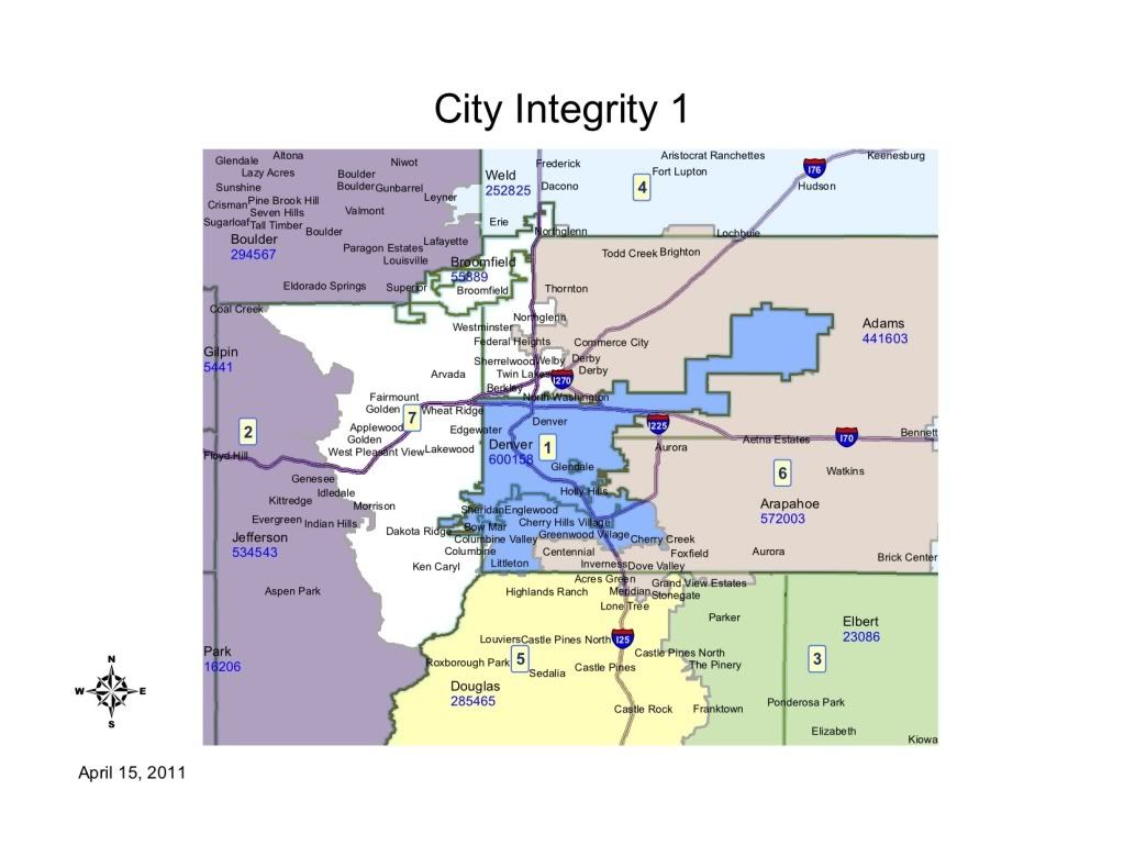
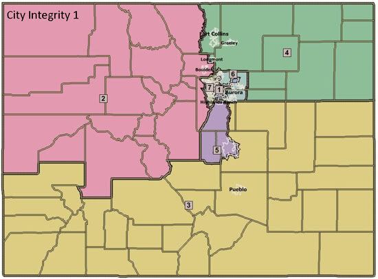
City Integrity 1

First, the Democrats map, known as “City Integrity 1.”  This is my personal favorite of all the Democratic maps and it’s also the “cleanest map” according to Sen. Rollie Heath (D-Boulder), co-chair of the committee.  All of the “City Integrity” maps strived to follow transportation corridors as well as striving for competitiveness.  The 1st, 2nd and 7th CDs are consistent throughout all the Democratic maps.

Photobucket

Photobucket

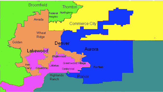
1st CD:  The 1st CD probably has the fewest changes.  It contains all of Denver County, Englewood, Cherry Hills Village, and Sheridan as before.  It adds Littleton, Greenwood Village, Bowmar, Cherry Creek Reservoir and some surrounding unincorporated areas of Arapahoe County.  The additions to the district are more Republican than the district as a whole, but the changes should be minimal, just making the district somewhat whiter than before.

2nd CD: The 2nd CD has some radical changes, going from it’s base in Boulder County (minus Longmont and Erie) west to take in all the north-west corner of the state.  The biggest new addition is Mesa County, one of the most Republican counties in the state and now the 2nd largest county in the district.  Chaffee, Lake and Park were taken from the 5th (as requested by the residents of Lake and Chaffee.  The district now includes all the major ski towns, Aspen, the oil and gas counties and the foothills towns in western Jefferson County.  If nothing else the district is now much more diverse in it’s interests and much more Republican.  The party break down is now 31 D, 31 R and 26 U, much more similar to the 7th CD when it was drawn a decade ago to be the most competitive.  We should be thankful Polis has more money than God and can probably hold this district in a non-2010 year.

3rd CD: The biggest disappointment of this map (especially to House Minority Leader Sal Pace of Pueblo) is the new 3rd CD.  It does a great job of keeping together the communities of interest in southern Colorado (despite what Republicans say, the south has more in common than the western slope and eastern plains as a whole).  It still contains all of Pueblo, but also adds Fremont, the rest of Otero, all the rural plains counties south of I-70 and the non-Colorado Springs portions of El Paso county, as well Parker and rural parts of Douglas county.  Overall this makes for a much more Republican district, probably out of reach for Democrats, but if you had to cut one loose, this was probably the district to do it with as several of the blue areas are shifting more and more R every year (San Luis Valley, Pueblo, Las Animas, Huerfano).  It still keeps Rep. Tipton’s home in Montrose so he can’t be too disappointed.

4th CD: The 4th CD needed to lose population and it did it with the most Republican parts of the district, now ending at Arapahoe/Washington/Yuma rather than taking in all the eastern plains down to the New Mexico Border.  It also loses the western half of Larimer County to the 2nd.  Most of the population lives in eastern Larimer so not much change other than shedding many republican precincts.  It then adds Erie and the eastern portions of Adams and Arapahoe counties, which are republican but not nearly as much as the counties given up.  These changes probably produce a district Obama and McCain were even in, if not a slight Obama win.  It becomes more winnable for Democrats, but still very competitive.  Sen. President Brandon Shaffer (D-Longmont) has to be pleased with this map as it keeps him in the district for a potential run.  Rep. Cory Gardner would not be happy at all with this district, but definitely still won it in it’s new configuration and the district keeps his home in Yuma.

5th CD:  Officially the southern I-25 corridor district, the 5th probably becomes even more Republican, adding most of Douglas, while shedding the swingier Chaffee and the blue Lake County.  Maintaining the home of Rep. Lamborn and also maintaing the districts center of gravity in Colorado Springs, the district will be to his liking (except for the absence of Fort Carson, which is now in the 3rd).  This is the beginning of the screwing-over of Rep. Coffman by taking out his best area in Douglas.  

6th CD:  The best change this map makes is the changing of the 6th from a suburban-Republican stronghold to a swingy eastern-suburban district.  While it keeps Coffman’s home in Aurora, he’s basically screwed in this district.  The extent to which this district takes in parts of Douglas and/or Weld changes between maps, but the heart of the district is the Arapahoe suburbs not in the 1st and most of the Adams Co. suburbs, including all the most hispanic areas.  Obama certainly won this district and in any normal year it would elect a solid Dem candidate.  This is probably the biggest reason this map will never be acceptable to the Republican House (while they have no love for Coffman I can’t see them being this willing to give up a safe seat).

7th CD: Another great change is in the 7th CD.  Keeping it’s base in Jefferson County, it sheds most of it’s Adams Co. areas and all of Aurora.  It then adds all of Arvada, Westminster, Northglenn and Broomfield (formerly in the 2nd).  It also takes in the Ken Caryl and unincorporated Jeffco (sometimes referred to as part of Littleton).  The district probably doesn’t change much in it’s tilt (maybe a very slight shift to the right), but it does remove the possibility of a Ryan Frasier challenge as he lives in Aurora.  This district makes more sense, while also maintaining it’s competitiveness.

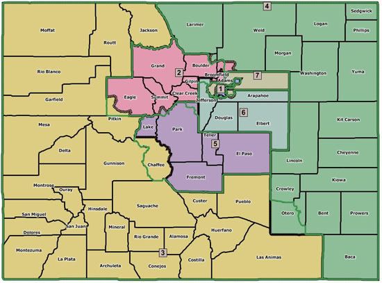
Balmer Map 1

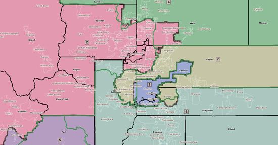
The first Republican Map, known as “Balmer Map 1” for it’s author Rep. Balmer (R-Foxfield).  It is typical of all the Republican maps, keeping to the current boundaries as much as possible.  The biggest changes are the removal of Chaffee county from the 5th, the rest of Otero county in the 4th and more of Weld into the 2nd and southern Aurora into the 7th.  

The map below has helpful green lines where the current districts are so you can track the changes.

Photobucket

Photobucket

1st CD: Few changes here, but to add population the lines were moved from the county line between Denver to Jefferson (Sheridan Blvd.) to Wadsworth Blvd., all the precincts in between include parts Wheat Ridge and Lakewood and are probably some of the most Democratic precincts in Jefferson county.  The district remains as Democratic as before.

2nd CD: Biggest changes here were putting south-west Eagle County into the 3rd, a sliver of summit into the 5th to balance population there and the addition of Fort Lupton in Weld County.  The meter will be moved very little here either.  

3rd CD: The addition of Chaffee county is the biggest change along with the removal of the rest of Otero.  Little change here, but maybe a smidge in the Democratic direction.  

4th CD: Only the addition of the rest of Otero and the removal of Fort Lupton, doubtful to have much impact on the partisan make up.

5th CD: Removal of Chaffee county and the addition of the rest of Park and the Summit County Sliver, making it just a point or 2 more Republican.

6th CD: While appearing to have little change, the 6th actually has the most radical change in that it removed Rep. Coffman’s home in southern Aurora and puts it in the 7th!  Coffman has already reacted to the maps, lashing out at the Democratic maps for not including his home in his current district, when in fact they do…  But he plans to move to Greenwood Village, so he is actually angry at his future home being removed from the district and isn’t mad at the Republicans at all for screwing out of a district in their maps.  Gotta love that!

7th CD: Almost no change, except now being the home to Rep. Coffman!  

Likely result

Unless the “Kumbaya Committee” suddenly has a desire to actually work together, looks like neither of these maps or any of the other 10 maps will make it.  The rural Republicans are already screaming about the dividing of the eastern plains and western slope, which they consider to be “communities of interest.”  So we’re more likely than not to have the issue before the courts.  Lucky for Dems the Colorado Supreme Court is packed with Democratic-appointed Justices and in 2000 they chose the current map, which was proposed by Democrats.  
Democratic Debauchery in Colorado (Redistricting)

After a careful look at the state after coming up with a redistricting plan the first time around, I decided to be more aggressive, bringing the delegation to a possible 6-1 breakdown.  In another scenario I tried to create a majority Hispanic district, but while doable it makes a 6-1 breakdown impossible and would depose one of our current Democratic Reps.

I’m going off the assumption that Democrats retain both houses of the legislature and the Governor’s mansion, a tough fight but I think that’s how it’ll end up.  

This time the goals were to: A) Make Markey safe, B) shore up Salazar at least a little, C) Keep Perlmutter, Polis and DeGette in reasonably solid Districts, and D) transform one of the other 2 districts into a swing district.

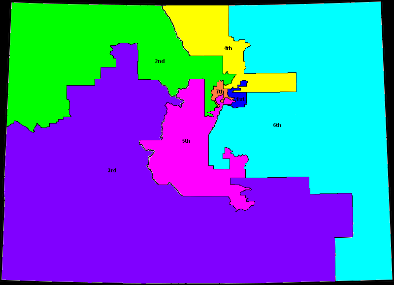
Here’s a map of the result:

2010 Colorado Congressional Districts

And a look at the metro area…

Photobucket

1st CD: Diana DeGette v. Mike Coffman

Population: 706,016

58% White, 13% Black, 20% Hispanic

This district still retains a substantial Denver county presence, keeping DeGette’s home in east Denver, the Denver portion runs roughly from Elyria Swansea in the north, keeping Capitol Hill, Wash Park and all the neighborhoods north of I-25 up to Virginia Village, then everything east and south of that neighborhood is in the 7th.  Denver now makes up 38% of the district.

The 1st now includes all of Aurora, including the far-flung areas and Foxfield before going south into Douglas County, picking up most of Lone Tree and a good chunk of Parker.  It also manages to pick up Mike Coffman’s home, removing him from any Republican district.

Despite extending into Douglas county, only about 26% of the 1st is Republican leaning, with another 18% of the district in southern Aurora that could be considered swingy.  with a majority still solidly Democratic and such a large minority population DeGette should have no problem holding the seat.

Having the 1st go south all the way into Douglas allows the 6th to also move south, picking up the blood-red areas in northern El Paso County.

2nd CD: Jared Polis

Population: 705,761

77% White, 16% Hispanic

As much as I wanted to draw Polis out of this district, I didn’t want to put any of Boulder County in any other district, so Polis can stay to grandstand another day.  

This district remains anchored in Boulder County, extending into Broomfield, Thornton, Northglenn, Federal Heights and Westminster in Adams County, and Grand County as it did before.  From there, however it becomes radically different.  

The 2nd extends into Jackson County, northern Routt County (excluding Steamboat), Moffat, Rio Blanco, Garfield (west of Rifle), and several precincts in Mesa County, including Fruita and parts of Grand Junction.  It also goes south into Jefferson, picking up the foothills area of Evergreen and Conifer.

This move was meant to draw as many Republican votes out of the 3rd as possible without turning the 2nd into a swing district.  It does have the nice effect of diluting the People’s Republic of Boulder more than it has been in the past, however, a side-effect I’m happy to see.

Once again, despite the move into more Republican territory, only 13% of the district leans Republican now, with another 41% even considered less than solidly Democratic.  (I included Broomfield, Northglenn, Westminister, Thornton and Federal Heights in that number, definitely pessimistic to call it swingy).

3rd CD: John Salazar

Population: 705,635

70% White, 24% Hispanic

Making Salazar too much safer would be pointless, he has a proven ability to hold this district by wide margins, despite Obama only getting 47% here in the old district.  There is room for improvement, however, just to be safe and keep the “Penry scenario” out of relevance.  

The biggest changes were to add  Eagle, most of Summit, Lake, Crowley, the rest of Otero, and Bent.  The latter counties are all small enough and friendly enough to Democrats to not make much difference, the ski counties, however, help a great deal in making this district less Republican, along with the territory taken by the 2nd.

The only other change was the loss of a handful of precincts in Pueblo County.  So overall still more of a swing district, with 37.5% of the district leaning Republican and another 7% more swingy, the rest at least leans Democratic.  Obama would have definitely won this district, but not overwhelmingly.

4th CD: Betsy Markey

Population: 705,422

68% White, 26% Hispanic

In terms of voting percentage, the 4th is pretty drastically changed.  Going from a narrow Obama loss to a solid Obama win.  By losing all the rural plains counties as well as eastern Weld county, there is only the increasingly blue Larimer county and the bluing southwest Weld county, including Greeley.  What is added here is all of Adams county except for Northglenn, Westminster, Federal Heights, and Thornton, making this district much more Hispanic as well.  So even if Cory Gardner were to win in 2010, he would be drawn out of the district and put into the 6th.  The result is a district where Obama received more than 54% of the vote.  

5th CD:

Population: 705,420

70% White, 24% Hispanic

This is the district I call “The Crab”, its the most severe gerrymander I could come up with given my limited data.  (Any other suggestions as to what this district looks like would be great!)  It goes from an El Paso County based district to going from most of Colorado Springs south into Fremont, through Park and Chaffee, back into Jefferson and Arapahoe, drawing out Lamborn.  The idea came from someone else on here, who wanted a springs-based district which Obama had won, but there’s not enough people in that area to make an entire district, so I had to get creative.

Put more specifically, this district takes in all the precincts Obama won in Colorado Springs and Fountain, as well as a few others that needed to be added to make the district contiguous, as well as Manitou Springs and Fort Carson, which Obama won.  Fremont and Park were both pretty solid for McCain, but their populations are negligible and there needed to be a link from this to the increasingly blue southern Denver suburbs to the north without going through Douglas.  To the south, the 5th takes in a few precincts in Pueblo County.

North of Park it includes Gilpin and Clear Creek and part of Summit, all of which went for Obama.  Once in Jefferson, the 5th avoids the wealthy Ken Caryl, and extends into Littleton in Jeffco for lack of a better name, once again leaving out the worst performing precincts, but still much of that area voted for McCain.  It then extends into southern Lakewood, going as far north as Mississippi Ave. and also part of Morrison.  Once in Arapahoe County the district includes Littleton, Sheridan, Englewood, Columbine Valley, Greenwood Village Cherry Hills Village and Centennial, leaving out Bowmar.  All of these except for Cherry Hills, with a population of just over 6,000 voted for Obama.  

So overall the 5th becomes extremely swingy, with 23% of the district leaning Republican and 41% of the district being made up of areas that are traditional swing areas.  There are definitely more Democratic voters now in the 5th than there have ever been, the 5th has never before been represented by a Democrat, but it should now be competitive enough to make that possible.  

6th CD: Doug Lamborn

Total Population: 705,583

81% White, 11% Hispanic

The 6th becomes a Democrats worst nightmare, taking in virtually all the most Republican areas.  The district takes in the rest of Douglas County and the rest of El Paso County, where Obama only one 2 precincts.  From there it extends into the heavily Republican Teller County, eastern Weld and Arapahoe Counties, and all the eastern plains counties not in the 3rd.  

With no Democratic areas to speak of and only 1% even remotely  swingy, this district isn’t even worth having a Democrat run in.  If Coffman were smart he would move into this district and fast!

7th CD: Ed Perlmutter

Total Population: 705,613

64% White, 28% Hispanic

The 7th retains its base in Jefferson County, keeping Perlmutter’s home.  It then also takes in all of west Denver includig the Civic Center, Lincoln Park, and most of Baker and east Denver south of I-25 and the Virginia Village neighborhood.    Its only Republican additions are part of south-east Jefferson near Sheridan & Bowles and Ken Caryl.  

Overall this district become more Democratic than before with only 5% of the district leaning Republican and 22% of the district being swingy.  (Golden, Arvada, and Westminster were considered swingy in this analysis.)  Obama would have won this district solidly.

Redistricting Colorado (2nd)

I decided to try redistricting in my home state of Colorado a while back, and after many many tries, I was able to put this together.  I know its been done, but mine is a little different.  

I used the 2007 estimates to put it together, since the 1st, 7th, 3rd, and 2nd won’t have enough people as they are to remain intact anyway.  

This map is assuming democrats continue to control both houses and the governor’s mansion, luckily its not likely that we lose any of the three.

My first goal was also making Markey safe, she’s a great representative, especially for such a traditionally red district, so wanted to pull her district out of the swingiest territory.  Second was changing the 3rd enough so that Obama would have won it, just shoring up Salazar some and keeping it really swingy, preventing most Colorado Republicans from winning there because they have moved so far to the right.  

With the 7th and 1st I wanted to make them more compact and make the 7th just safe no matter what, and wanted to dillute the blueness of the 2nd for the benefit of the 3rd.  

And then I tried to pack as many Republicans into the 5th and 6th as possible.

First the new 2nd would consist of all of Boulder county, retaining its center, Gilpin county, Broomfield county, the city of Thornton in Adams county, and the northern and western parts of Jefferson county that are not in the 7th.  On the western slope it would pull in Grand, Jackson, Routt, Moffat, Rio Blanco, and Garfield counties.  All of those except for Routt are generally red, and this would take those voters out of the 3rd, but the new 2nd would still be very blue with Obama getting about 63.6% of the vote.  

The new 3rd would retain its traditional base in Pueblo and the San Luis valley, and unfortunately I could not take out Mesa county, (the best suggestion I’ve gotten is to just let Utah have it) so I just tried bringing in other blue areas instead.  The counties added to the 3rd are: Clear Creek, Eagle, Summit, Lake, Baca, Crowley, the rest of Otero and most of Bent county.  Some of these are the eastern plains red areas but small enough or they vote for Democrats often enough to not make much difference.  In the new 3rd, Obama would have barely beaten mcCain with just 50.3% of the vote.

The new 4th is probably the most drastic change, and goes from a narrow Obama loss to a solid Obama win.  By losing all the rural plains counties as well as eastern Weld county, there is only the increasingly blue Larimer county and the bluing southwest Weld county, including Greeley.  What is added here is all of Adams county except for Commerce City, Westminster, and Thornton.  The result is a district where Obama received 54.4% of the vote.  

The new 1st and the new 7th are interesting, I had heard of an idea back in 2000 of splitting the city and coutny of Denver, so in this map I did that (to the best of my ability).  So the new 7th would contain all parts of Jefferson county that were in the old 7th with the addition of Westminster, the west side of Denver (including downtown), and the Adams county portion of Westminster.  The new 1st would contain the east side of Denver (including DeGette’s neighborhood), Commerce City, Aurora in Arapahoe coutny, Englewood, Cherry Hills Village, Glendale, and Littleton in Arapahoe county.  So the new 1st looks a little funky, but no more so than the city and county of Denver does anyway, and the new 7th is much more compact.  In the new 1st Obama received 68% of the vote and in the new 7th he received 64% of the vote.

The new 6th is much more republican and so out of our reach for the time being, but a 5-2 split was easier to protect than an attempt at a 6-1 split.  So the new 6th contains the rest of Arapahoe county, the rest of Jefferson county, and then Douglas county, Elbert county, and all the rest of the eastern plains counties, including eastern Weld county, and northeast Bent county.  In the new 6th Obama managed to get only 41.9% of the vote.

And the new 5th is almost identical to the old 5th, containing the counties of El Paso, Teller, Park, Chaffee, Fremont, and Custer.  Obama recieved 40.1% of the vote here.

So that’s what I came up with, with 3 solid blue districts, one leaning blue, one swing, and 2 solid red.

By what margin will Bob Shamansky win?

View Results

Loading ... Loading ...