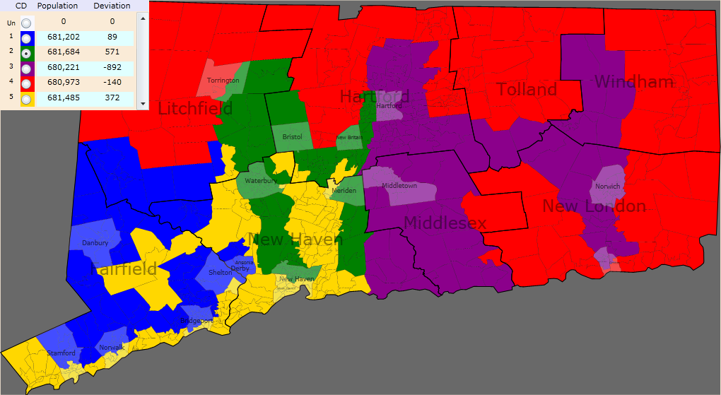
So, I said I’d actually play around with Dave’s Redistricting App. Unfortunately, I don’t really know my geography that well, as to what parts of what district are D or R leaning, or have significant populations of what minority groups, or where college town communities are, etc.. But I needed a goal to work toward.
I started trying to see how I could redistrict Rhode Island as closely following county lines as possible. But that was boring. The insane maps–such as abgin’s New York Baconmandering–are more fun. But I don’t know where anything is. Wait…I’ll stroke my ego by writing out my username’s initials!
The other requirements for this map were to get as close to an even division of population as possible, and to retain five districts.
Map and other info below the fold.

Fitting the G in there was rather hard. It still looks rather sloppy. Well, granted, so does the M. Next time, I should pick appropriate states for doing what I want to do with them…
I know a lot of cities were cracked. This is mostly for population balancing and location (i.e. letter-drawing) reasons.
FWIW, the population figures for these districts are as follows, according to Dave’s App. (They might not be totally correct: for example, a tiny district east of New Britain seems to contain no voters for some reason.)

Interestingly, I’ve ended up with three districts of about seventy-something percent white populations. Dunno if CT has enough minorities to trigger VRA restrictions, but I didn’t take them into account here anyway.
Who goes where? First thoughts suggest that all but the new 4th district might stay D, especially the second (central CT cities except Hartford and Middletown) and third (Hartford, Middletown, and Norwich). However, after trying to think for a bit about which incumbent should go where,…I became very confused. Maybe Himes could get the new CT-05, and give DeLauro the new CT-02, while Courtney and Larson can decide who gets CT-03 and CT-04. Larson would likely take 03, but amusingly, I would suddenly become represented by Joe Courtney. (Well, it was close anyway, I live next to Tolland County which is currently in Courtney’s district.) I guess this leaves C. Murphy to take CT-01…?
(Yes, Salisbury and Sharon are covered by the table, but you can safely assume they’re in the new 4th district.)
And then I pressed “Use New Pop Est”. And all the numbers changed and now I’m off by like 10,000 people in some districts. And I can’t change them back. And I don’t know how to load a map back into the App… Are these the new population counts from the 2010 Census data?
For some reason, coming up with a title for this made me think of “My Little Pony”. I’m not a fan of it, but I just realized that it might be amusing to produce a My Little Ponymander.
Unrelated note: If anyone was wondering what happened in the general election rematch for probate judge in my area between Brian Griffin and Marianne Lassman Fisher, here are the results: Griffin 13,458; Lassman Fisher 11,679. Griffin again won Windsor by a big enough margin to overcome Lassman Fisher’s combined smaller margins in East Windsor and South Windsor.


