By: Inoljt, http://thepolitikalblog.wordpr…
This is the second part of an analysis on the swing state Ohio.

Unlike Florida and Pennsylvania, Ohio cannot be easily divided into geographically distinct regions (although they do exist). Instead, I will be examining it through the lens of both partys’ strongholds in the state.
History
During the late eighteenth century Ohio was a consistently Republican state, the equivalent today of North Dakota or Arizona. Democrats often came close behind – four or five points – but never quite won the state until 1912. Their stronghold lay in a ring of rural counties populated by German immigrants (a pattern that has completely disappeared today). But this was never enough to overcome Republican strength everywhere else.
It was Franklin Roosevelt who changed this pattern forever. He laid the foundations of Ohio’s structural politics, which exist to this very day. Roosevelt brought in previously hostile working-class counties along the northeast section of the state. He also shifted most of Ohio’s northern cities to the Democratic side – which had previously leaned Republican.
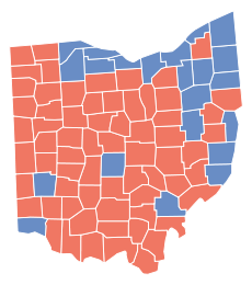
To see the effect, here is Roosevelt’s 2.85% victory in 1932:

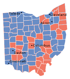
Here is his 4.4% victory eight years later:

The maps are practically inverses of each other – courtesy of the New Deal.
Democratic Ohio
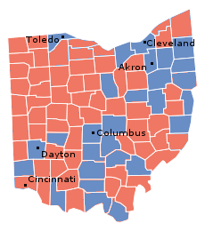
Today Roosevelt’s coalition remains, for the moment, intact; Democrats still dominate the union vote and northern cities. Because both populations reside along Ohio’s northern and eastern borders, Ohio’s Democratic results often form a blue “7.” The greater the Democratic margin of victory, the “fatter” and more defined the shape becomes.
For example, below the flip is Bill Clinton’s 1996 performance, in which he took the state by 6.4%.