After seeing the addition of partisan data for New York, I decided to try my hand at creating a 28-0 map of New York (well at least a map where Obama won 28 districts in 2008).
From the outset, there are a couple of assumptions that went into the design.
1) Keep intact county lines as much as possible.
2) Make it difficult for Republicans to win the district.
3) Ignore homes of incumbents (both R and D)
4) I also did not match up existing district numbers with the map
The top level description of the map is that I succeeded. In western NY, I grouped counties in an East-West manner, splitting Buffalo and stretching those districts from the Finger Lakes to Lake Erie. In eastern NY, I grouped counties North/South with Scott Murphy's District going from the Canadian border to Dutchess County. On Long Island, I split NY 2 to go East-West across eastern Suffolk and Nassau counties.
In the end, I created 28 districts Obama won, with only four district where Obama won with 51% of the vote or less.
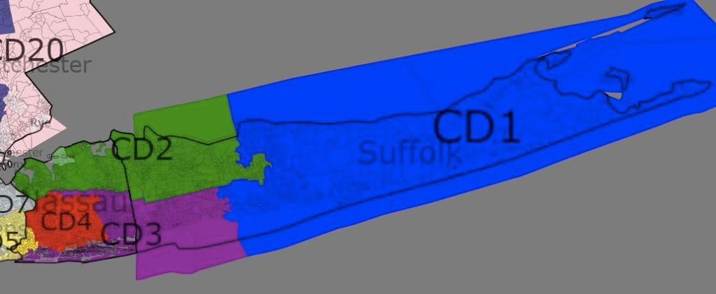
Long Island
The goal for Long Island was to create three Democratic performing districts in Suffolk and Nassau counties. To that end I was successful, however, there are two or three Districts that in the wrong year, could flip to the Republicans. However, since Democratic performance has been improving in this area, it is possible that demographic trends will preserve Democrats in this area.
CD 1: (blue) Suffolk – 83% White 8% Hispanic
52-47 Obama
CD 2: (green) Suffolk, Northern Nassau – 81% White 8% Hispanic
52-47 Obama
CD 3: (purple) Suffolk, Southern Nassau – 76% White 11% Hispanic
51-47 Obama
CD 4: (red) South and West Nassau – 65% White 15% Black 12% Hispanic
57-42 Obama
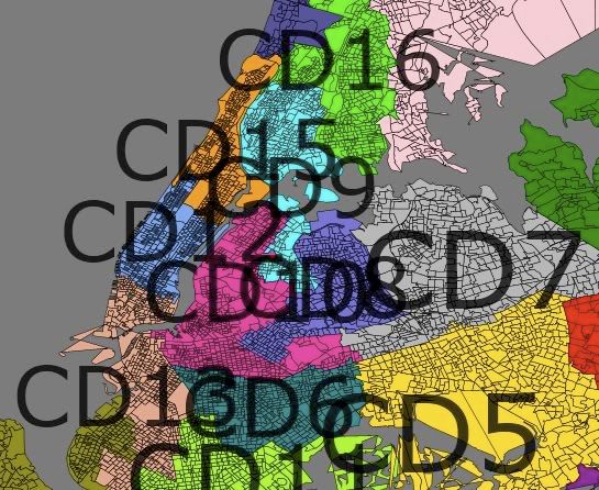
I admit I am not familiar with the actual New York City area to make an informed observation about these districts, but I do preserve a number of minority-majority districts. Only the Staten Island district may flip in a bad year.
CD 5: (yellow) South Queens – 22% White 49% Black 14% Hispanic
81-18 Obama
CD 6: Central Brooklyn – 6% White 73% Black 14% Hispanic
95-4 Obama
CD 7: (grey) Northern Queens – 42% White 27% Asian 18% Hispanic
65-33 Obama
CD 8: Northern Queens, Extends into Kings – 29% White 15% Asian 8% Black 43% Hispanic
74-25 Obama
CD 9: Northern Queens Bronx – 8% White 27% Black 5% Asian 56% Hispanic
90-8 Obama
CD 10: (magenta) Western Queens, Western King – 28% White 29% Black 30% Hispanic
87-11 Obama
CD 11: Southern Brooklyn – 57% White 18% Black 10% Asian 10% Hispanic
58-41 Obama
CD 12: Central/ West Manhattan – 70% White 6% Black 8% Asian 12% Hispanic
82-16 Obama
CD 13: Lower Manhattan/Brooklyn – 53% White 6% Black 17% Asian 18% Hispanic
77-21 Obama
CD 14: Staten Island/Brooklyn – 63% White 6% Black 10% Asian 17% Hispanic 51-47 Obama
CD 15: Harlem/East Side – 21% White 27% Black 45% Hispanic
90-8 Obama
CD 16: (green) Bronx/SE Yonkers – 19% White 30% Black 41% Hispanic
85-14 Obama
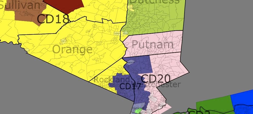
Rockland, Westchester area
I have three districts extending out of New York City into Yonkers and Rockland and Westchester counties. This arrangement is similar to, but expands upon the current map of the area. where both NY 17 and NY 18 extend into the City.
In the existing eastern most district, NY 18, Representative Lowey has consistently won with over 65% of the vote (Bush/Kerry 58%) – this performance may go down with this map's NY 20. However, this is necessary to strengthen (this map's) NY 18 (Hall), where Obama would have a more comfortable victory.
CD 17: Bronx, W. Westchester, SE Rockland – 64% White 12% Black 15% Hispanic
61-37 Obama
CD 18: (yellow) Orange, S Sullivan, S Ulster, N Rockland, Poughkeepsie – 79% White 7% Black 9% Hispanic
54-44 Obama
CD 20: (pink) Putnam, E Westchester, E Bronx 89% White
53-44 Obama
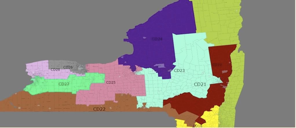
Upstate NY
Upstate New York keeps counties intact and create nine districts where Democrats should be expected to win in most elections. However, in the right circumstances several districts could flip. However, I expect that no conservative Republican could win in these areas – especially with the trends in New England in support of Democrats.
Unlike the existing map, I took a more radical approach to dividing the districts, weakening the existing District around Albany (Tonko) and around Binghamton (Hinchey). I support Murphy and Owens, as well as take out Lee. However, this map does not respect the residence of incumbents as Owens and Murphy are placed in the same district as well as Maffei and Arcuri.
CD 19: (ugly green) Franklin, Clinton, Essex, Washington, Rensselaer (-Rensselaer), Columbia, Dutchess (most) – 89% White
53-44 Obama
This is Scott Murphy's current district. I help him by extending the district all the way to the Canadian border, and the Democratic leaning counties of Franklin and Clinton counties.
CD 21: (red) Warren, Saratoga, Albany, Greene, Delaware (most), NE. Ulster – 88% White 5% Black
56-42 Obama
I take the Tonko's Albany based district, and go North to Saratoga and then South into Delaware and Ulster counties. The district also includes the City of Rensselaer.
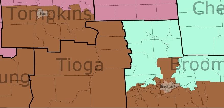
CD 22: (brown) Chautauqua, Cattaragus, Allegany, S. Steuben, Chemung, S. Tompkins, S. Broome, S Delaware, N. Sullivan (includes Binghamton and Ithica) – 89% White
51-46 Obama
Of all the districts that undergo a change, perhaps the most radical change is to Hinchey's district. The district now spans most of New York's southern border, but expands North to take in the city of Ithica. This district is perhaps the toughest to defend in a wave election, but the Democratic strongholds of Ithica and Binghamton should prevent a Republican from staying in office long.
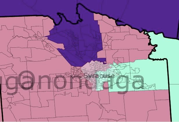
CD 23: (light blue) N. Broome, Chenango, Madison, Ostego, Herkimer, Fulton, Montgonery, Schoharie, Fulton, Hamilton, Onodaga (part) – 90% White
52-46 Obama
This is the district I had the most fun drawing – as it streches across most of Central New York, connecting Syracuse and Schenectady and into the Binghamton suburbs. This is a Democrat performing district, but would vulnerable in a wave election.
CD 24: (purple) St. Lawrence, Jefferson, Lewis, Oneida, Oswego, Onodaga (part) 91% White
50-48 Obama
Because I was not concerend about where incumbents live, I was able to create a Democratic leaning district in Northern New York. The district extends into the Syracuse suburbs to preserve a Democratic lean.
CD 25: Onodaga (Syracuse and S), Wayne, Cayuga, Seneca, Yates, N. Steuben, Schulyer, N. Tompkins, Cortland 90% White
52-46 Obama
With the City of Syracuse divided between the 23rd and 25th, this district expands westward. In a wave election, a Republican could take the district, but turnout in Syracuse should prevent that.
CD 26: (dark grey) Monroe (most), Orleans – 76% White 13% Black 5% Hispanic 58-40 Obama
I make the Rocester area whole -but add in the more conservative Orleans county.
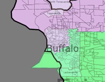
The Buffalo area retains the exsiting split – but both then stretch Eastward to take some of the rural counties in Western NY. Obama still won each of the districts with over 53% of the vote.
CD 27: S and E Erie, Wyoming, Livingston, Ontario – 85% White 10% Black 53-44 Obama
CD 28 – N Erie, Niagara, Genese, S Monroe – 84% White 8% Black 54-43 Obama
In conclusion, a 28-0 vote is possible, but because of the voting patterns in Central and Western NY, a 28-0 map will leave several Democrats vulnerable to a wave election, especially if one goal is compactness and the preservation of county borders.
I see a couple of big problems with this map.
You addressed one, by stating that seats could flip in a bad year and to me, there are far too many seats that could do that. I would be more than willing to give the Republicans one seat they are likely to win to make sure that the other 27 seats are more secure in their Democratic lean.
The other problem, is the very nature of the seats themselves. They are mostly very close seats. Its unlikely that we’ll get a really good Democrat out of most of them. I think it would be much better to, again, give up a seat to the Republicans to make stronger Dem holds, and since you have already given us a district where we have a small advantage, that seat could still be a winnable seat for a blue dog.
The third problem, is the fact that they are all competetive. It could potentially be very costly to try and defend so many seats in a bad year.
Could be made more secure by doing something geographically counter-intuitive and creating three or four skinny districts running longitudinally across LI, incorporating more voters from Queens and Brooklyn to dilute the strength of suburban GOPers. A blatant gerrymander, but that is of course the point. Probably the best bet to get rid of Peter King.
For that matter, will Eric Massa survive next year when he currently sits in the most Republican seat in NY by PVI? Perhaps, then Shelly Silver will opt to combine the Republican elected there with Chris Lee. This would actually make a good deal of sense as that’s where a lot of the really bad Republican precincts in the state are clustered (e.g., Alleghany, Steuben, Wyoming countries where Obama got less than 42% and in many cases a lot less than that). If I did that, then Hinchey could shift westward to pick up some of the cities in the Southern Tier that we don’t get too creamed in such as Elmira and Corning (which would actually make sense as they are a community of interest with Ithaca and Binghamton). Then, perhaps Arcuri could share the Democrats of Tompkins County with Hinchey, thus shoring up that district.
In all likelihood, I think we are looking at the peak of Democratic performance with a 27-2 delegation, and after the 2010 midterms, we will probably wind up with something closer to 24-5 (with probably 3 out of Hall, Murphy, the Dem who won CD 23, Arcuri, and Massa losing). I’m sorry I’m pessimistic: it’s just with the disaster of the Paterson governorship and the fact that we’re at 10% unemployment, I think we have to look at the very realistic possibility that a lot of the Dems washed in in the 2006 and 2008 elections will be washed out in 2010.
Nice job Edward. Last night I uploaded a new version of the app that fixes the CD label mess that one gets in NYC. The labels are way smaller and you can move them around! You could remake that NYC image if you want.
Enjoy.
attempt to draw a map where they control all upstate seats. That would just be insane. Even trying for all-but-one is arguably dangerous. Here’s my working map so far:
The 26th district is 58% McCain, and the 21st sinks most of the eastern Republicans in Albany. I have a map that creates a 59% McCain district, but it really redefines modern art.
If the Dems should be so lucky as to have a monopoly on state government in New York next legislature, they’re going to have some really difficult decisions to make.
Im new in Dave’s Application and i can not until now. Someone can help me? I have an interesting way for Maryland with 8-0 D+8 (61% Obama) to D+10 (63% Obama) districts so compacts.
About New York i think a 28-0 is possible because democratic party is winning now R+2, R+3 and R+5 districts, and would be much more easy with minimum D+2 or D+3 districts.
I think the 28-0 is the best option.