Choices in Washington Redistricting

At the Washington State Democratic Central Committee meeting this past January, over lunch the delegates discussed the ramifications of the addition of a 10th Congressional District in the State. The goals discussed in the meeting was to ensure that a Democrat would be elected in the new 10th. There was general recognition that the 3rd would go from Vancouver to the outskirts of Yakama (along the Columbia River).

With three districts generally accounted for (the 3rd, 4th and 5th), the main question becomes how the Puget Sound area is divided. In Washington, the redistricting law states that plans should consider electoral competition and not purposefully favor or discriminate against any political party (among all of the normal provisions).

In practice, this means that the bipartisan redistricting commission gets the sign-off by the elected representatives (encouraging little change in the composition in the district, both geographic and partisan). For 2011, this means that Representative Dicks will want a more Democratic district (especially if he loses parts of Tacoma), and Representative Reichart wants a more rural, and Republican district.

With the addition of a 10th District in Washington, the choice facing the redistricting commission is to create 6-8 safe districts (3 safe Democratic 3 safe Republican) or to create a map with 4 safe districts (2 D – 2 R) and another 4 districts that are likely Democratic. (The difference really is should Democrats want to lock in a third safe Republican district in eastern King, Pierce, and Thurston counties or draw a map that is 7-3 in most years [including 2010]).

Photobucket

If the goal is to create 7 Democratic (or competitive) districts west of the Cascades (creating a 7-3 [or in the worst years a 6-4] split), then the existing Representatives should be willing to trade a bit of comfort and security for the potential for more Democratic representatives from Washington.

Some basic rules for redistricting in Washington:

1) While it may be the dream of many Democrats to split Seattle, it is not going to happen. The commission respects geographic cohesiveness, and sending a spur from Seattle to a) the Olympic Peninsula, or b) to Kirkland or Bellevue is not going to happen.

2) The redistricting commission likes to create competitive districts.

3) Two and a half districts will be in Eastern Washington.

Photobucket

Photobucket

Photobucket

Redistricting Washington

So, 6 districts left to draw. Two districts will have their roots in Whatcom, Skagit and Snohomish County. Representative Larson lives in Lake Stevens, west east of Everett. However, if Representative Inslee runs for Governor, then Larson could either run in the 1st or 2nd (and could be happy either way, since he would want more of Everett anyway).

For me, the key to redistricting Washington lies with not where the new 10th District goes, but what will the 6th District go? And, what does Representative Norm Dicks want from this round of redistricting?

The current 6th District includes Bremerton, Representative Dicks' residence, most of the Olympic Peninsula, and extends into Pierce County and has to shed 37,000 people.

If Representative Dicks gets anxious and wants a district that a) resembles his current district and b) becomes more Democratic, then the Democrats lose the redistricting game (and likely all decade). Either the 10th or the 8th District will be a Solid Republican district. If he is a team player, and accepts a Democratic leaning district that has lots of new constituents, Democrats win (or have a better chance of winning). Then, the 8th and 10th will be lean Democratic seats (or better).

The following maps present two options for a 10th CD and the competitiveness of each district (again, the 3rd, 4th, and 5th stay the same).

Option 1: Dicks remains concerned about his reelection

In this scenario, the 6th CD is the entire Olympic Peninsula, the Washington Coast, and most of Cowlitz County and the cities of Olympia, Tumwater and Lacey. While losing his portion of Tacoma, Dicks gains the remainder of Democratic-leaning Kitsap County, and Democratic leaning Olympia. While Dicks is secure about his reelection, the population of the state mean that a Republican-leaning district must be created.

Photobucket

With the Olympic Peninsula off the map, the 1st and 2nd become located entirely in Whatcom, Skagit, and Snohomish County. The 2nd adds Everett, making Larson happy. The 1st (open) becomes southwestern Snohomish counties and several King county cities – Shoreline, Lake Forest Park, Kenmore, Redmond, Bothell and Woodinville.

Photobucket

Photobucket

Up to this point – good for the Democrats – 3 stronger seats.

South of Seattle, Representative Smith's (Tacoma) district can also be strengthened – include all of Tacoma and western Pierce County, and include the cities of Kent, Renton, Federal Way, and the other cities immediately South of Seattle not part of the 7th.

Photobucket

So, 4 stronger seats for the Democrats (and all geographically compact).

Now the rub. there are few Democratic areas left in the State to draw two more competitive districts (or better). The 10th ends up in Eastern King County centered around Bellevue. This is the area where Democrats have done well in 2006, 2008, and 2010.

Photobucket

The elusive 8th district becomes the remainder of the State – Auburn, Eastern Pierce County, Lewis County, and rural portions of Thurston County.

Photobucket

So, the end result of Western Washington is 1 SR seat and 4 safer Democratic seats. In essence, this is the status quo and Washington's delegation would be 6-4 for the majority of the decade (with the slim possibility of winning back the 3rd).

But Democrats could do better.

Option 2: Dicks accepts a district with more new constituents

The 6th CD includes Bremerton and other Democratic portions of Kitsap county (Bainbridge Island), Olympia and all of Thurston County, and Pacific, Wahkiakum counties (as well as Lewis County). Every county (or portion of) the county is Lean D (or better) except for Lewis County. While the District would be lean D, and potentially competitive, it would still likely be a Democratic seat the entire decade.

Photobucket

With 2 counties and portions of Kitsap on the Olympic Peninsula not part of the 6th, you then draw a district across the Sound to Whatcom County (via Island and San Juan Counties). The 2nd CD can be all of Snohomish (with a portion of Democratic Shoreline).

Photobucket

Photobucket

So, here we have 2 likely Democratic district and 1 safe Democratic districts.

The 8th CD becomes a Democratic leaning district by adding the King County cities of Federal Way, Kent, Renton, Tukwila, Newcastle and SeaTac. While Representative Reichert still lives in the district, he has lots of new Democratic cities to deal with.

Photobucket

The 9th is a Pierce County district centered around Tacoma.

Photobucket

Again, this is two additional lean/likely Democratic districts.

The new 10th is now exclusively an Eastern King County district.

Photobucket

In this scenario, each district would be competitive (at worse for the Democrats), but likely, year in and year out, sending 7 Democrats to DC.

And, did I say from the outset that the commission likes competitive districts?

To summarize:

Option 1 (max deviation 174):

3 safe Democratic seats, 3 lean/likely Democratic seats, 3 safe Republican seats, 1 likely/lean Republican seat.

Option 2 (max deviation 140):

2 safe Democratic seats, 2 safe Republican seats, 4 lean/likely Democratic seats, 1 likely/lean Republican seat.

Bonus – State Legislature Map (max deviation 590):

Photobucket

Snohomish County

Photobucket

King County

Photobucket

Pierce County

Photobucket

Thurston County

Photobucket

Kitsap County

Photobucket

Clark County

Photobucket

Benton County

Photobucket

Spokane County

Photobucket


By what margin will Bob Shamansky win?

View Results

Loading ... Loading ...

Wyoming Rule – Analysis

Over the past few weeks there has been a flurry of diaries about the Wyoming Rule (California, Texas, New York, Pennsylvania, Tennessee, Maryland, Oregon, New Mexico, and my Washington map below). Many of these diaries asked at the end what they thought about the Wyoming Rule, and the intent of this diary is to examine some of the benefits and drawbacks of the Ruie itself. 

The primary benefit of the Wyoming Rule is that the districts are smaller for many states – or about 75%-80% the size of the current projected district size. California would go from 52 seats to 68, Washington from 10 to 12, and Oklahoma from 5 to 7. Other states would stay the same – Hawaii, Nebraska, and Rhode Island.  (The number of districts for each state was researched by borodino21). The range between states would drop from about 400k (Rhode Island to Montana) to 300k (South Dakota to Alaska).

The smaller district sizes in most states means that there are more opportunities to preserve communities of interest. For some states like North Carolina, this means it may be possible to create additional minority-majority or minority-influence districts. In other states, it may be possible to draw more CDs that encompass only one county or city.

While I do not wish to subscrible to albguy's method of creating as many Democratic districts as possible (while I do enjoy his method of pushing the limits of a redistricting map), the smaller districts may make it harder to create all Democratic seat maps.

In Washington, a more realistic map under the Wyoming Rule likely means two safe(r) Republican seats in Western Washington and two or three safe Republican seats in Eastern Washington. Now perhaps one or two of those districts may be better considered swing districts (especially a Vancouver to Yakama district), but the result of the Wyoming Rule is a 7-5 delegation (compared with the current 5-4 delegation with the possibility of a 6-4 delegation after the 2011 redistricting).

The Wyoming'd New York faces a similar problem. In jsramek's New York – the delegation would be 30 Democrats and 6 Republicans. This map also includes the cracking of Staten Island, which would probably not be politically viable – even for a solidly Democratic state legislature. While this is better than the 8 Republicans representing NY in the 2011-2012 Congress, many of the maps made for the Redistricting Contest would contain 1 or 2 Republicans out of New York's 28 Congressional Districts. 

The resaons for these results is that the smaller district sizes make it more difficult to crack Republican strongholds – or areas without overwhelming the nearby Democratic area. So, back to New York, at least 4 upstate districts are created as Republican vote sinks, instead of the possibilty of spreading them out. In Western Washington, eastern King, Pierce, Thurston and Clark counties are Republican areas, as well as Lewis and most of Cowlitz counties. In some maps, it is possible to divide those populations and combine them with more Democratic areas such as Vancouver, Olympia, Tacoma, and Bellevue to allow for Democrats to win those districts (but as in the 2010 elections, Republicans held on in WA 8 [East King and Pierce County] and won in WA 3 [SW Washington including Olympia]). With smaller districts, you can create two safe Republican districts in those Republican areas in exchange for two additional safe Democratic districts (and possibly another swing district). 

So, where does that leave us?  I think the advantages of the Wymonig Rule outweigh the drawbacks. More representation is better from a democracy standpoint, but it also helps Democrats in the big picture. For all of the concerns about not being able to maximize Democratic seats, the Republicans would not be able to either. In addition, more Congressional seats will also help Democrats in the Electoral College.


Washington Redistricting v.2.0

Earlier this year I posted a diary creating a 10 district Washington State. With the update to Dave’s Redistricting, I thought I would update my proposed redistricting map of Washington.

Washington has a bipartisan commission for redistricting, so at best the map is going to strive for balance or the creation of swing districts.

Photobucket

In this map, I make a return to the delegation maps of the 1960s, where the 2nd Congressional district connected Whatcom County along the Canadian border with Clallam County along the Pacific Ocean. (Actually, that district contained all or portions of Clallam, Island, Jefferson, King, San Juan, Skagit, and Snohomish Counties). Also in this map, the new 10th CD is an Tacoma (Pierce County) based district while the 3rd CD connects Bremerton with the Pacific Coast. Should this map be adopted, I would think that the delegation would be 7-3, and possibly 9-1 in a strong Democratic year if and as the cities Spokane and Yakama trend towards Democratic candidates.

Photobucket

CD 1 – Inslee (D – Bambridge Island) or open

White – 82%
Asian – 3%
Hispanic – 5%

Photobucket

As I wrote in the introduction, the 1st CD connects Whatcom County in the north with Jefferson County along the Olympic Peninsula. The district is connected via the Keystone to Port Townsend ferry. The district also includes the northern half of Kitsap County (Kingston and Bambridge Island), extending to the southern edge of Bremerton.

The district will be a swing (at worse) district that leans Democratic. Of the counties in the new district, Jefferson, Kitsap, and Whatcom county voted for Patty Murray, while Clallam still gave her 46%. While Rick Larsen won a squeaker in 2010, most of the Republican leaning area of his district (East Snohomish County) is now in the 2nd CD.

CD 2 – Larsen (D – Lake Stevens)

White – 83%
Asian – 6%
Hispanic – 5%

Photobucket


The 2nd is now entirely in Snohomish County. The only City not in the CD is Stanwood.

The district should be a sold Democratic district. There are 4 Democrats on the Snohomish County Council and 1 Republican. A portion of the Republican district is not in the 2nd CD, while the districts of the remaining 4 Democrats are in. Still, there is a potential for an upset in a bad year, but Patty Murray did win 51% of the vote in Snohomish County.

CD 3 – Norm Dicks (D – Bremerton)

White – 85%
Asian – 3%
Hispanic – 5%

The 3rd CD connects Bremerton in Kitsap County to Longview and Kelso in Cowlitz County. The district includes Olympia and Centralia and Chehalis in Lewis County (the district splits Lewis and Cowlitz counties [mostly down 1-5]). The district also includes Gig Harbor in Pierce County.

With Olympia and Bremerton, and as well as the Democratic lean along the Pacific Ocean (Murray won in Pacific, Gray’s Harbor, and Thurston counties), the district should remain a Democratic one.

Photobucket

CD 4 – Jamie Herrara (R – Camas)

White – 79%
Hispanic – 13%

The 4th CD is a Columbia River district and extends north to the City of Yakama.

Photobucket

For the near term, this would be a Republican district. Over time, it is possible that the City of Yakama returns to its Democratic roots (the area did elect Jay Inslee in 1992) and with Vancouver, become a Democratic-performing district.

CD 5 – Cathy McMorris-Rodgers (R – Spokane)

White – 83%
Hispanic – 10%

It may not be possible to elect a Democrat east of the Cascades, but combining the Tri-Cities with Spokane may be the only way to do so. The district includes the cities of Spokane and Spokane Valley in Spokane County, but nothing to the west or north.

The district does have the advantage of placing Representative Hastings (Pasco) and McMorris-Rodgers into the same district (but I would not expect them to run against each other).

Photobucket

CD 6 – Open or Doc Hastings (R – Pasco)

White – 79%
Hispanic – 15%

This 6th CD takes in all of the rest of Eastern Washington not in the 4th or 5th and supplements that population with a small portion of Eastern Pierce County. This is a solid Republican precinct.

CD 7 – Jim McDermott (D – Seattle)

White – 68%
African American – 8%
Asian – 13%
Hispanic – 6%

This is the City of Seattle and Vashon Island. Not much to say here (except this would be one area where having city boundaries on v.2.0 would be especially nice).

CD 8 – open

White – 82%
Asian – 9%
Hispanic – 4%

This district is the district that any of the challengers to Dave Reichert would have wanted. In the north, all of the northern King County cities (and reliably Democratic) (Shoreline, Lake Forest Park, Kenmore, Kirkland, Redmond), combine with Bellevue to balance the Republican portion of east King County.

Photobucket

CD 9 – Dave Reichert (R – Auburn)

White – 71%
African American – 6%
Asian – 10%
Hispanic – 7%

Photobucket

The 9th CD retains most of its current form, extending north to Renton and east to Auburn, while it loses most of its portion of Pierce County. What remains is all (or most of the south end of King County – a distinct region in King County politics).

This swing district that never really swung, becomes a more solidly Democratic district.

CD 10 – Adam Smith (D – Tacoma)

White – 73%
African American – 8%
Asian – 7%
Hispanic – 6%

The district includes Tacoma and portions of South and East Pierce County.

Pierce County is a swing County, but the Republican portions of Pierce County are not in this CD. The 6th CD has lots of east Pierce, and the 9th has a chunk of north-central Pierce County. A Democrat should retain this seat.

Photobucket

At the end of the day this map is compact, yet would probably yield a 7-3 Democratic split in the delegation most years. If there was another Republican wave, potentially 2 more Democrats could be endangered – in a Democratic wave, 2 Republicans would be endangered.

By what margin will Bob Shamansky win?

View Results

Loading ... Loading ...

Washington Redistricting 10 CDs

With the news that Washington state may receive a 10th Congressional District, I set out to develop a map that is favorable to Democrats and should lead to a 7-3 delegation split in bad years, and up to an 8-1 split in good years.

Washington has a bipartisan redistricting commission, so massive gerrymanders are off the table. When Washington received a 9th CD, the commission attempted to make the 9th competitive – I expect the same to happen with a 10th CD.

Anyway, this map creates a super-strong Republican seat east of the Cascades, and generally puts each major city in the Western portion of the state in its own district and connects that city with more rural portions of Western and Central Washington. (BTW, partisan data would be helpful here).

Photobucket

WA 1 (Inslee [open]-D) [Blue]

WA 1 still extends across Puget Sound to Kitsap County, but loses Bambridge Island and some Seattle precincts and extends to the eastern most portions of Snohomish County. The Kitsap portion of the District, as well as the western Snohomish portion should keep this District a safe Democratic one.

Photobucket

WA 2 (Larson D) [Green]

WA 2 retains much of its current form – Northwestern Washington. Like it does now, the district extends into Everett. If Larson holds on this year, the District should remain a Democratic hold.

WA 3 (open D) [purple]

WA 3 runs along the Columbia River and the Pacific Ocean. Inland it includes solidly Lewis County. In many years, this would be a Democratic seat, but control depends on who wins Clark County (and the City of Vancouver).

The coastal counties are more Democratic, and Skamania and Klicikat Counties did vote for Obama in 2008. In 2010 and 2012 this might be a tough hold, but as Vancouver becomes more solidly Democratic, so should the entire CD.

Photobucket

WA 4 (Hastings – R) [Red]

This district encompasses most of Eastern Washington – or at least Yakama and most of the low population counties east of the Cascades. Currently, both WA 4 and WA 5 are about 40-45% Democratic – this district would probably push that number to about 35%.

Tri-Cities

WA 5 (McMorris-Rogers – R) [Yellow]

While it may not be possible to create a safe Democratic district in Eastern Washington, connecting the Tri-Cities to Spokane may do the trick (to at least elect a Democrat – or make it a swing district). Whitman County voted for Obama and Spokane has two Democratic Senators in Olympia.

Spokane

WA 6 (Dicks-D) [Teal]

WA 6 connects Olypmia to Kitsap County and extends to the Pacific Ocean. All of these counties are fairly reliable Democratic counties. Fairly in the sense that King, Snohomish, and sometimes Pierce Counties lead the way on Democratic issues in the state.

WA 7 (McDermott – D) [Grey]

Seattle.

Puget Sound

WA 8 (Reichert – R) [Lavender]

WA 8 is strongly contested in 2010 by Suzan DelBene. Likely, the 2010 election will depend on how well she does in Pierce County.

To solidify the district, I chose to add several Democratic areas to the district – Renton and Kirkland. To add population to the district, I added the central Washington counties of Chelan and Kittitas. This is an area where I would like more partisan details, but both counties have voted for Democratic presidential candidates in the past.

Photobucket

WA 9 (Smith – D) [Bright Blue]

WA 9 was originally designed as a swing district twenty years ago – but has only been held by a Republican for only 2 years (1995-1997). For this map, it should stay a Democratic seat.

The district goes from the Seattle border to Puyallup and from Puget Sound to east King County.

WA 10 (open) [Magenta]

This new district is a Pierce County district. It includes Tacoma and Gig Harbor – and then races out to eastern Pierce county. This district should be competitive – or leaning Democratic in the worst years.

**Sorry for the quick write-up (I published the Diary before I was ready). Each district is + or – 744 from the ideal population size.

California Redistricting

There seems to be a flurry of people attempting to redistrict California, so my plan may seem less adventurous than others – especially when compared to the Herculean effort by Silver Springs.

However, I have a different purpose – I want to create a Democratic map that respects existing political lines – cities and counties. The bottom line is that I create a map that creates 39 safe Democratic seats, 8 safe Republican seats, and 6 toss-up seats (each of the toss-up seats were won by Obama. Based on the 2000 demographic data, I create a map with 31 minority-majority districts, including 10 majority Hispanic districts and a plurality African-American district. (*I believe that my CA 45 will be minority-majority with the new census).

Like my NY contest entry, I claim that a safe Democratic seat is one where Obama won with 55% of the vote (Seven Republicans represent districts that gave Obama 55%/16 Republcans represent districts Obama won by over 53%). I have included in my description of each district where the current incumbents live, but their residences did not play a factor in how I drew the map. The map also has no deviation in district size greater than 702.
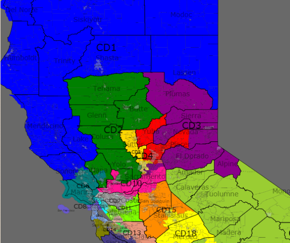
Photobucket

Photobucket

Photobucket

Northern California

In Northern California, there are five seats, Currently, Republicans hold three of the seats.

In this map, I created three safe Democratic seats, one tossup and one safe Republican seat. To do this, I decided to weaken CA 1 and pack Republicans into CA 4. I did keep the City of Sacramento intact, while dividing the rest of the county amongst 4 other districts.

CA 1 Current Incumbent – none

Population – 706,684

White Black Asian Hispanic
Race 80% 1% 2% 10%
Obama McCain Kerry
Old District 66% 32% 60%
New District 55% 42%  
Change -11% +10% -5%

This district sheds territory in the Sacramento Valley for counties on California’s northern border – Siskiyou, Shasta, Modoc, and Lassen counties. While Representative Thompson no longer resides in the district, he, or another Democrat should continue to find this seat winnable.

CA 1 and CA 2 are tough districts to draw. On one hand, I could draw one very safe Democratic district that includes Humbolt, Mendicno, Lake, Napa and portions of Yolo (and Solono) counties. On the other hand, I could draw two 55% Obama districts. At worse, both seats are toss-up seats in open-seat elections.

CA 2 Current Incumbent – Thompson (D-St Helena); Herger (R-Chico)

Population – 706,763

White Black Asian Hispanic
Race 68% 3% 6% 19%
Obama McCain Kerry
Old District 43% 55% 37%
New District 55% 44%  
Change +12% -12% +18%

The Northern California districts in the current map generally align North-South, creating two safe Republican seats. In my map, District 2 goes down the West side of the Sacramento Valley, extends into Napa County and South to Vacaville. This should be a strong Democratic seat, and Representative Herger should be in trouble.

CA 3 Current Incumbent – Lundgren (R-Gold River)

Population – 706,602

White Black Asian Hispanic
Race 70% 5% 7% 12%
Obama McCain Kerry
Old District 43% 55% 37%
New District 53% 45%  
Change +10% -11% +16%

The Northern California districts in the current map generally align North-South, creating two safe Republican seats. In my map, District 2 hugs the Nevada border, from Plumas to Alpine County. The District stretches into Sacramento County and takes in the suburban areas immediately to the east and south of Sacramento.

This will likely be a swing district for the foreseeable future, but I expect that growth will occur in the Sacramento suburbs and the district will continue to trend Democratic.

CA 4 Current Incumbent – none

Population – 706,552

White Black Asian Hispanic
Race 78% 2% 5% 11%
Obama McCain Kerry
Old District 44% 54%  37%
New District 44% 54%  
Change 0% 0%  +7%

CD 4 is composed of the northern Sacramento suburbs and exurbs in Placer and Yuba counties, as well as the Cities of Folsom and Citrus Heights in Sacramento County. Representative McClintock (Thousand Oaks) still does not live in this district.

Reflecting the changing demographics, the district becomes slightly less white than before 84% – 78%, but it is unlikely to become more hospitable for Democrats anytime soon.

CA 5 Current Incumbent – Matsui (D-Sacramento)

Population – 706,349

White Black Asian Hispanic
Race 50% 12% 1% 14%
Obama McCain Kerry
Old District 70% 28%  61%
New District 64% 34%  
Change -6% +6%  +3%

Photobucket

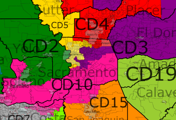
The District encompasses the City of Sacramento and extends north to Sutter County. The District becomes slightly whiter and more Republican, but it remains a safe Democratic seat.

This District is a minority-majority seat.

CA 10 Current Incumbent – Garamendi (D-Walnut Grove)

Population – 706,645

White Black Asian Hispanic
Race 52% 11% 12% 21%
Obama McCain Kerry
Old District 72% 27%  67%
New District 61% 37%  
Change -11% +10%  -6%

This district remains a split Bay Area/Sacramento County District. It stretches from Vallejo in the West to the Southern Sacramento suburbs. It dips into Contra Costa County to encompass the cities of Antioch and Oakley and parts of Pittsburg. It also takes in conservative Lodi in San Joaquin County.

Representative Garamendi should like this district, despite the drop in Democratic performance, since he is now a resident of the district.

Bay Area

All safe Democrats.

Photobucket

Photobucket

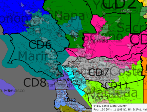
CA 6 Current Incumbent – Woolsey (D-Petaluma)

Population – 706,661

White Black Asian Hispanic
Race 75% 2% 4% 16%
Obama McCain Kerry
Old District 76% 22%  70%
New District 66% 24%  
Change -1% +2%  +5%

CA 6 stays fundamentally the same, only taking in the City of Napa and losing parts of Sonoma County.

CA 7 Current Incumbent – Miller (D-Martinez)

Population – 706,254

White Black Asian Hispanic
Race 65% 6% 12% 14%
Obama McCain Kerry
Old District 72% 29%  67%
New District 66% 32%  
Change -4% +3% 1

This district now stays entirely in Contra Costa County.

CA 8 Current Incumbent – Pelosi (D-San Francisco)

Population – 707,082

White Black Asian Hispanic
Race 46% 8% 30% 13%
Obama McCain Kerry
Old District 85% 12%  84%
New District 85% 13%  
Change 0% +1%  +1%

Slightly whiter than the current district

This is a minority-majority district.

CA 9 Current Incumbent – Lee (D-Oakland)

Population – 706,732

White Black Asian Hispanic
Race 35% 25% 1% 17%
Obama McCain Kerry
Old District 88% 10%  86%
New District 89% 9%  
Change +1% -1% +3%

Oakland, Berkeley, Richmond.

This is a minority-majority district.

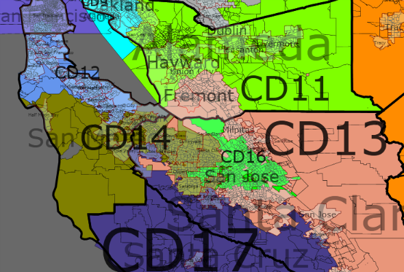
CA 11 Current Incumbent – McNerney (D-Pleasanton)

Population – 706,025

White Black Asian Hispanic
Race 47% 10% 18% 20%
Obama McCain Kerry
Old District 54% 44%  45%
New District 70% 28%  
Change +16% -16% +25%

CA 11 stays in Alameda County and extends slightly north to Southeastern Contra Costa County. The district goes from a swing district to a safe Democratic seat. This does not have a detrimental affect on the Democratic lean in San Joaquin County.

This is a minority-majority district.

CA 12 Current Incumbent – Speier (D-Hillsborough)

Population – 706,600

White Black Asian Hispanic
Race 45% 3% 27% 20%
Obama McCain Kerry
Old District 74% 24%  72%
New District 74% 24%  
Change 0% 0% +2%

Parts of San Francisco, Northern and Eastern San Mateo County.

This is a minority-majority district.

CA 13 Current Incumbent – Stark (D-Fremont)

Population – 706,283

White Black Asian Hispanic
Race 44% 3% 27% 22%
Obama McCain Kerry
Old District 74% 24%  71%
New District 68% 31%  
Change -6% +6% -3%

This district now extends from Fremont in the North, circles around to the east and takes in part of South San Jose, and goes south to Gilroy.

Most of Stark's base is now part of McNerney's district (CA 11), but the change is necessary to shore up McNerney's seat. When Stark retires, a Democrat should easily pick up this seat.

This is a minority-majority district.

CA 14 Current Incumbent – Eshoo (D-Menlo Park)

Population – 706,637

White Black Asian Hispanic
Race 55% 3% 23% 15%
Obama McCain Kerry
Old District 73% 25%  68%
New District 73% 25%  
Change 0% 0% +5%

CA 14 now stays out of Santa Cruz County, and extends east into the cities of Los Altos, Mountain View, Sunnyvale, Santa Clara, Cupertino, Saratoga, and Campbell.

CA 16 Current Incumbent – Honda (D-San Jose); Lofgren (D-San Jose)

Population – 706,632

White Black Asian Hispanic
Race 30% 4% 28% 34%
Obama McCain Kerry
Old District 70% 30% 63%
New District 71% 28%  
Change +1% -2% +8%

It is difficult placing two Democrats in one seat, but with one of my goals to preserve City lines mostly intact, San Jose should be in one seat. However, packing Democrats in the Bay Area does not negatively affect seats elsewhere, and cracking the Bay Area leads to ugly looking districts throughout the state.

While preserving current incumbents can be valuable, the value of a map should be viewed as a whole, rather than any one particular district.

CA 17 Current Incumbent – Farr (D-Carmel)

Population – 706,776

White Black Asian Hispanic
Race 55% 2% 6% 33%
Obama McCain Kerry
Old District 72% 26%  66%
New District 72% 26%  
Change 0% 0% +6%

Photobucket

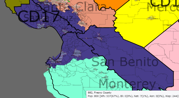
CA 17 encompasses Santa Cruz and San Benito Counties, and northern Monterey County (including the cities of Carmel and Monterey).
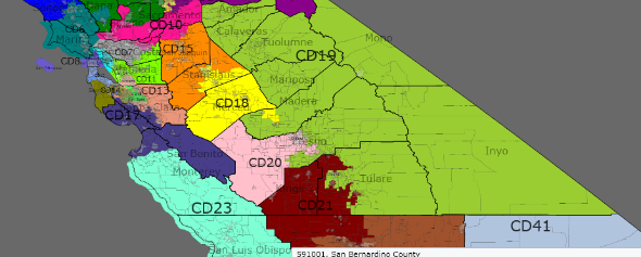
Central Valley

In the San Joaquin Valley, I create two 55% Obama districts, two 50% Obama districts and a solid Republican district. Assuming that a 55% district will elect a Democrat except in the largest Republican wave years, the worst that can happen in this area is exactly what is the current Congressional Delegation split (3 R – 2 D). In this case, the Republican districts will lean Democratic and only grow stronger because of the demographic changes in the area.

CA 15 Current Incumbent – none

Population – 706,846

White Black Asian Hispanic
Race 47% 7% 11% 31%
Obama McCain Kerry
Old District  
New District 55% 43%  
Change  

Photobucket

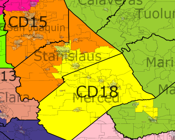
CA 15 is a new district based in Stockton and rural Stanislaus County. In many respects, the district will reflect the political nature of the entire state, and with a growing Hispanic population, should grow more Democratic as the decade goes on.

This is a minority-majority district.

CA 18 Current Incumbent – Cardoza (D-Atwater)

Population – 706,832

White Black Asian Hispanic
Race 48% 3% 6% 38%
Obama McCain Kerry
Old District 59% 39%  49%
New District 52% 46%  
Change -7% +7% +3%

Representative Cardoza will face challenges in this swing district. Personally, he was elected in 2002 with only 51% of the vote, so he should be able to remember how to run a competitive election (he was unopposed in 2008).

The district runs from Modesto to Merced, and extends a bit south to Democratic precincts in east Madera (bypassing Chowchilla). The district is rapidly growing, and the demographics should continue to favor Democrats by the end of the decade.

This is a minority-majority district.

CA 19 Current Incumbent – Radanovich (R-Madera) or new member

Population – 706,439

White Black Asian Hispanic
Race 65% 2% 3% 26%
Obama McCain Kerry
Old District 46% 52%  38%
New District 39% 59%  
Change -7% +7% +1%

CA 19 is a very safe Republican district bordering Nevada, from Amador County to Tulare County in the South. The district splits the city of Madera in Madera County with CA 18. In Fresno County, conservative-leaning Clovis is in CA 19.

CA 20 Current Incumbent – Costa (D-Fresno)

Population – 700,226

White Black Asian Hispanic
Race 34% 6% 9% 46%
Obama McCain Kerry
Old District 60% 39%  51%
New District 56% 42%  
Change -5% +4%  +4%

Photobucket

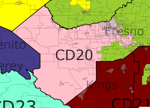
This Fresno-based district now stays entirely in Fresno County. Obama’s performance drops slightly to preserve compactness.

This is a minority-majority district. I expect it will soon be a majority-Hispanic district.

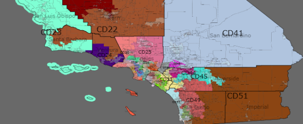
CA 21 Current Incumbent – Nunes (R-Tulare)

Population – 706,283

White Black Asian Hispanic
Race 31% 6% 4% 55%
Obama McCain Kerry
Old District 42% 56%  34%
New District 50% 48%  
Change +8% -8%  +16%

Photobucket

King County, Portions of Tulare and Kern Counties. Democratic-leaning precincts in East Bakersfield are also in this district.

The current district goes north from Tulare County into Fresno County. Although I considered drawing Rep. Nunes out of this district, his residence in Tulare is among the most Democratic part of this district. A Democrat may have a hard time unseating Representative Nunes, but the demographic nature of the district will make it a swing seat in normal election years.

This is a majority-Hispanic district.

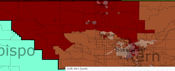
CA 22 Current Incumbent – McCarthy (R-Bakersfield)

Population – 706,992

White Black Asian Hispanic
Race 64% 4% 3% 26%
Obama McCain Kerry
Old District 38% 60%  31%
New District 38% 60%  
Change 0% 0% +7%

Photobucket

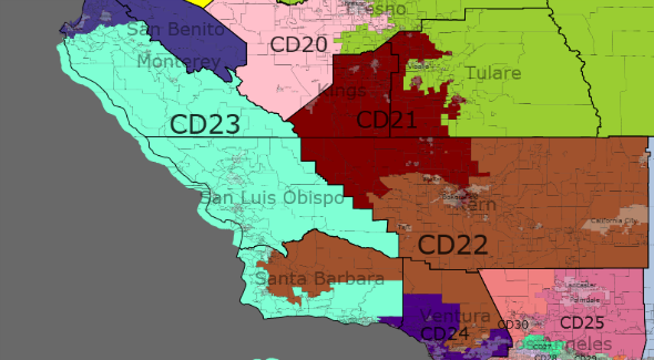
CA 22 remains centrally located in Kern County; it does lose precincts in Bakersfield, and all of San Luis Obispo and Los Angeles Counties. It gains Republican areas in Santa Barbara County and Ventura County, including the cities of Camarillo and most of Moorpark.

CA 23 Current Incumbent – Capps (D-Santa Barbara)

Population – 706,162

White Black Asian Hispanic
Race 62% 2% 4% 29%
Obama McCain Kerry
Old District 66% 32% 58%
New District 58% 40%  
Change -8% +8%  0

Photobucket

Much of the Republican gain in this district come from the addition of all of San Luis Obispo and Monterey Counties, where the eastern portions of those counties are not as Democratic as the cities and precincts along the Pacific Ocean.

The district continues to be a strong Democratic district.

CA 24 Current Incumbent – Gallegly (R-Simi Valley); McClintock (R-Thousand Oaks)

Population – 707,144

White Black Asian Hispanic
Race 55% 2% 5% 34%
Obama McCain Kerry
Old District 51% 48% 43%
New District 57% 41%  
Change +6% -7% +14%

The fruits of these changes in the Central California Coast is changing a swing (lean Republican) district into a solid Democratic district. I do not think that Elton Gallegly would survive in this district, after losing the conservative portions of Ventura and Santa Barbara Counties to CA 22.

Los Angeles County

Los Angeles County has 14 whole Congressional Districts and only has one district split between it and Orange and Riverside Counties. All 14 CD's are Democratic leaning.

Photobucket

CA 25 Current Incumbent – Dreier (R-San Dimas)

Population – 706,354

White Black Asian Hispanic
Race 46% 11% 6% 33%
Obama McCain Kerry
Old District 49% 48% 40%
New District 56% 42%  
Change +7% -6% 16%

The statistics for this district, which is entirely in Los Angeles County are for CA 25, but Representative Dreier (CA 26) resides in the district. The district includes Lancaster and Palmdale in the North, and Pomona in the Southeast.

A Democrat should be able to win this district, especially since most of the district would be new territory for Representative Dreier.

This is a minority-majority district.

CA 27 Current Incumbent – Schiff (D-Burbank)

Population – 706,392

White Black Asian Hispanic
Race 32% 4% 9% 51%
Obama McCain Kerry
Old District 66% 32%  59%
New District 67% 31%  
Change +1% -1% +8%

Photobucket

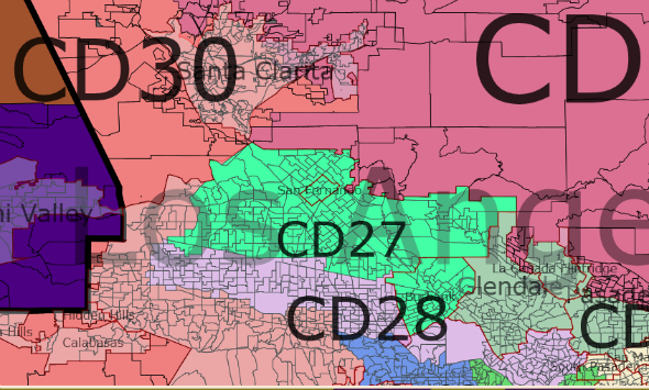
CA 27 is a Los Angeles – Burbank district. My guess is that the district includes Northridge, Panorama City, San Fernando, and Mission Hills, among others.


The district is a majority-Hispanic district.

CA 28 Current Incumbent – Sherman (D-Sherman Oaks), Berman (D-Valley Village)

Population – 706,769

White Black Asian Hispanic
Race 30% 4% 10% 51%
Obama McCain Kerry
Old District 76% 22%  71%
New District 75% 23%  
Change -1% +1% +4%

CA 28 stretches across Nothern Los Angeles, from (what I would say) Resenda to Van Nuys, to North Hollywood through Griffith Park to Atwater Village.

The current districts were drawn to ensure that both incumbents resided in different districts. Short of carving out a few precincts to draw Rep. Berman into the 27th, as both Representatives live around 4 miles from each other, I kept the districts more or less compact.

This is a majority-Hispanic district.

CA 29 Current Incumbent – none

Population – 706,337

White Black Asian Hispanic
Race 38% 5% 17% 35%
Obama McCain Kerry
Old District 68% 31% 61%
New District 64% 34%  
Change -4% +3% +3%

CA 29 retains the core of the old district, Glendale and Pasadena, but loses Burbank and Alhambra, gaining more northern and eastern suburbs, Sierra Madre, Monrovia, and Aduza.

While Representative Schiff now resides in CA 27, the district should remain a solid Democratic seat.

This is a majority-minority district.

CA 30 Current Incumbent – Waxman (D-Beverly Hills)

Population – 706,711

White Black Asian Hispanic
Race 74% 3% 8% 11%
Obama McCain Kerry
Old District 70% 28%  66%
New District 63% 36%  
Change -7% +8%  -3%

Waxman's district hugs the Los Angeles – Ventura County line, from Kern County through Santa Clarita to Malibu, and then extends eastward through Los Angeles to Beverly Hills.

CA 32 Current Incumbent – Miller (R-Diamond Bar)

Population – 705,921

White Black Asian Hispanic
Race 23% 3% 21% 50%
Obama McCain Kerry
Old District 68% 30%  62%
New District 61% 37%  
Change -7% +7% -1

Photobucket

This district swings easterly. In the North, the district includes Glendora and Covina, in the west: Irwingdale, Baldwin Park and El Monte, and in the south and east: La Habra Heights, Walnut and Diamond Bar.

Representative Chu's residence is now in CA 38, but a Democrat should easily win this district.

This is a majority-Hispanic district.

CA 33 Current Incumbent – Watson (D-Los Angeles)

Population – 706,250

White Black Asian Hispanic
Race 25% 5% 16% 51%
Obama McCain Kerry
Old District 87% 12%  83%
New District 79% 19%  
Change -8% +7% -4%

CA 33 wraps around West Hollywood.

This is a majority-Hispanic district.

CA 34 Current Incumbent – Becerra (D-Los Angeles); Roybal-Allard (D-Los Angeles)

Population – 706,977

White Black Asian Hispanic
Race 5% 7% 5% 81%
Obama McCain Kerry
Old District 80% 18%  77%
New District 85% 13%  
Change +5% -5% +8

This district includes East Los Angeles, Vernon, Maywood, Huntington Park and portions of Los Angeles County.

This is a majority-Hispanic district.

CA 35 Current Incumbent – Waters (D-Los Angeles)

Population – 706,135

White Black Asian Hispanic
Race 2% 50% 2% 43%
Obama McCain Kerry
Old District 84% 14%  79%
New District 94% 5%  
Change +10% -9% +15%

This is a South Los Angeles, Inglewood, Compton district.

This is a majority-minority district.

CA 36 Current Incumbent – Harman (D-Venice)

Population – 706,943

White Black Asian Hispanic
Race 45% 11% 12% 28%
Obama McCain Kerry
Old District 64% 34%  59%
New District 77% 21%  
Change +13% -13% +18%

Photobucket

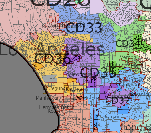
CA 36 extends from Santa Monica to Hawthorne, and has an arm through central Los Angeles. The district becomes much stronger Democratic, as it stays more compact and northerly. A challenger to Representative Harman should find much easier terrain.

This is a minority-majority district.

CA 37 Current Incumbent – Richardson (D-Long Beach)

Population – 706,336

White Black Asian Hispanic
Race 8% 19% 10% 60%
Obama McCain Kerry
Old District 80% 19%  74%
New District 80% 19%  
Change 0% 0% +6%

CA 37 is a donut shaped district around the City of Compton. It includes the cities of Gardena, Carson, northern Long Beach, Paramount, Lynwood, and South Gate. I am not sure if Representative Richardson would actually lives in this district.

This is a majority-Hispanic district.

CA 38 Current Incumbent – Napolitano (D-Norwalk), Linda Sanchez (D-Lakewood)

Population – 707,067

White Black Asian Hispanic
Race 35% 7% 14% 41%
Obama McCain Kerry
Old District 66% 32%  59%
New District 63% 35%  
Change -3% +3% +4%

* Old District CA 39

Photobucket

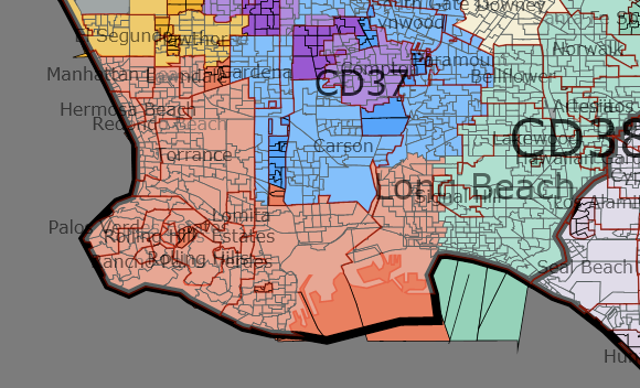
Someone who is reading to this point may think, wait a second, why are there so many Democratic primaries in this map. I want to remind the readers that the current map is a Republican gerrymander, and second, I am more concerned with the entire state delegation rather than one individual. In this particular district, Representatives Napolitano and Sanchez reside in nearly adjacent cities. From pieces from the current CA 36, CA 37, and CA 46, we can create a Democratic performing district from Manhattan Beach to Long Beach. We could then carve up northern Orange County and create two marginal Democratic performing seats – one for Rep. Napolitano and one for Rep. Sanchez. I prefer the stronger seat and one seat that has the potential to become more Democratic performing.

This district extends from Long Beach to Sante Fe Springs along the Los Angeles County border.

This is a minority-majority district.

CA 39 Current Incumbent – none

Population – 706,502

White Black Asian Hispanic
Race 18% 2% 24% 54%
Obama McCain Kerry
Old District 54% 44%  
New District 65% 33%  
Change 0% +2%  

This district stretches from South Pasadena and San Marnio to Whittier and Downey. The district includes parts of the current CA 38, CA 32, and CA 34.

This is a majority-Hispanic district.

CA 46 Current Incumbent – none

Population – 706,184

White Black Asian Hispanic
Race 41% 7% 15% 33%
Obama McCain Kerry
Old District -% -%  
New District 60% 38%  
Change -% -%  

This district is the payoff in reversing the Republican gerrymander. In this district, located from Torrence to Long Beach along the Pacific, a Democrat should win comfortably in most election cycles.

This is a minority-majority district.

Orange County

Orange County is currently split into 6 districts, and a Republican holds 5 of them. However, Obama won 3 of those districts in 2008. In this map, I create two safe Democratic seats, and only split Orange County five ways – with only one district extending out of the County.

Photobucket

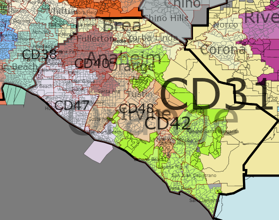
CA 31 Current Incumbent – Calvert (R-Corona)

Population – 707,092

White Black Asian Hispanic
Race 58% 3% 7% 28%
Obama McCain Kerry
Old District 50% 49% 40%
New District 44% 54%  
Change -6% +5% +4%

*old stats are for the current CA 44.

Representative Calvert's district becomes a safe Republican district that extends into Los Angeles County to take in the City of La Mirada, the Orange County cities of Brea and Yorba Linda, and the western edge of Riverside County, including Corona, Murietta and Norco.

CA 40 Current Incumbent – Loretta Sanchez (D-Garden Grove), Royce (R-Fullerton)

Population – 706,539

White Black Asian Hispanic
Race 28% 3% 14% 53%
Obama McCain Kerry
Old District 60% 38% 49%
New District 55% 43%  
Change -5% +5% +6%

*old district stats for CA 47

Photobucket

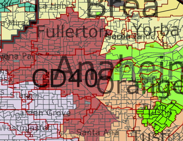
This district combines Fullerton, most of Anaheim, and portions of Santa Ana and Garden Grove to create a competitive, but strongly leaning Democratic district in the north-central part of Orange County.

This is a majority-Hispanic district.

CA 42 Current Incumbent – none

Population – 706,001

White Black Asian Hispanic
Race 74% 1% 8% 14%
Obama McCain Kerry
Old District 45% 53% 37%
New District 43% 55%  
Change -2% +2% +6%

This district includes the eastern portion of Anaheim, and Orange, extends South to include the suothern cities of Orange County, and extends north along the Pacific Ocean to include Laguna Beach and portions of Newport Beach. A Republican is very safe here.

CA 47 Current Incumbent – Rohrabacher (R-Huntington Beach)

Population – 706,996

White Black Asian Hispanic
Race 56% 1% 21% 18%
Obama McCain Kerry
Old District 48% 50%  42%
New District 45% 53%  
Change -3% +3% +3%

*old district stats for CA 46

Photobucket

This district is an entirely Orange County district, encompassing the cities of Cypress, Seal Beach, Huntington Beach, Fountain Valley, and most of Garden Grove and Newport Beach.

This district should remain a safe Republican seat.

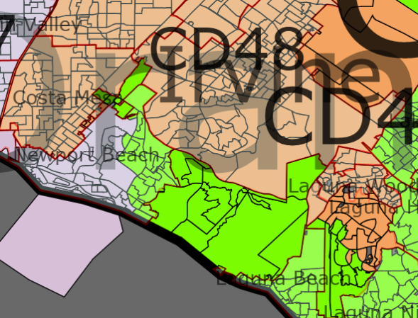
CA 48 Current Incumbent – Campbell (R-Irvine)

Population – 706,454

White Black Asian Hispanic
Race 45% 2% 14% 36%
Obama McCain Kerry
Old District 49% 49% 40%
New District 56% 42%  
Change +7% -7% +16%

Creating a second Democratic leaning district in Orange County was not too difficult. I combine the cities of Irvine, Tustin, Costa Mesa and Laguna Woods, and portions of Orange and Santa Ana.

This is a majority-minority district.

Remainder of Southern California – San Bernardino, Riverside, San Diego, Imperial Counties

Currently only three Democrats represent parts of any of these Southern California counties. In my map, Democrats should represent at least 5 districts, Obama won two more districts, and Republicans should only have two safe seats.

Photobucket

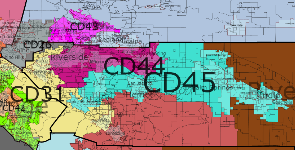
CA 26 Current Incumbent – none

Population – 706,612

White Black Asian Hispanic
Race 39% 7% 7% 43%
Obama McCain Kerry
Old District 51% 47% 44%
New District 53% 45%  
Change +2% -2% +9%

CA 26 is now located in San Bernardino and northern Riverside County. It includes the cities of Chino, Chino Hills, Ontario, and Rancho Cucamunga. This is a toss-up district, but should lean Democratic most years and the demographics favor the district becoming more strongly Democratic.

This is a minority-majority district.

CA 41 Current Incumbent – Lewis (R-Redlands)

Population – 706,905

White Black Asian Hispanic
Race 63% 6% 3% 23%
Obama McCain Kerry
Old District 44% 54% 37%
New District 42% 55%  
Change -2% +1% +5%

This district is located entirely in San Bernardino County. It includes Representative Lewis' residence in Redlands, and the cities of Yucaipa, Victorville and Hesperia.

This is a safe Republican district.

CA 43 Current Incumbent – Baca (D-Rialto)

Population – 706,526

White Black Asian Hispanic
Race 27% 14% 4% 51%
Obama McCain Kerry
Old District 68% 30% 58%
New District 66% 32%  
Change -2% +2% +8%

This district remains a safe Democratic district and a majority-Hispanic district. It includes the cities of San Bernardino, Fontana, Colton and Rialto.

This is a majority Hispanic district.

CA 44 Current Incumbent – none

Population – 706,679

White Black Asian Hispanic
Race 43% 10% 6% 37%
Obama McCain Kerry
Old District 50% 49% 40%
New District 56% 42%  
Change +6% -7% +16%

This is now a solid Democratic district in northern Riverside County. The district includes Riverside, Moreno Valley, Banning, and Beaumont.

This is a minority-majoirty district.

CA 45 Current Incumbent – Bono Mack (R-Palm Springs)

Population – 707,189

White Black Asian Hispanic
Race 51% 4% 2% 40%
Obama McCain Kerry
Old District 52% 47% 43%
New District 53% 46%  
Change 0% -1% +9%

The percentages stay the same in CA 45, but the district becomes more urban. Palm Springs, Indio, and Coachella in the east are united with Lake Elsinore, Perris, and Hemet in the west.

I am not quite sure what percentage of the district is new, and I would expect that Representative Bono Mack could eke out a few more terms, but the demographics of the district are on our side, and a Democrat would likely to be favored in an open-seat election.

CA 49 Current Incumbent – Issa (R-Lakeside)

Population – 706,383

White Black Asian Hispanic
Race 70% 2% 4% 21%
Obama McCain Kerry
Old District 45% 53% 38%
New District 39% 59%  
Change -6% +6% +1%

Photobucket

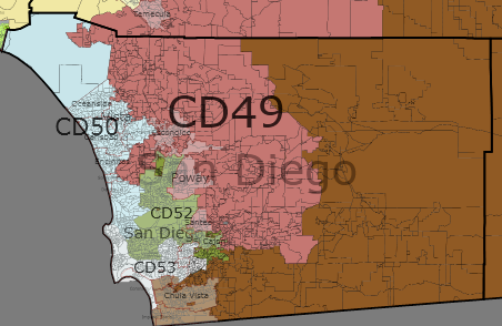
This district starts in the north along the southern border of Hemet, takes in Temecula and skirts along the city of San Diego eastern border, encompassing Escondido, Poway and Santee.

This is a very safe Republican seat.

CA 50 Current Incumbent – Bilbray (R-Calisbad) Hunter (R-Vista)

Population – 707,238

White Black Asian Hispanic
Race 63% 3% 7% 23%
Obama McCain Kerry
Old District 51% 47% 44%
New District 54% 44%  
Change +3% -2% +10%

Photobucket

Two Republican incumbents in a district where Obama won with over 54%. Ah, fun with redistricting.

The district lies entirely in San Diego County along the Pacific Ocean, Oceanside, Vista, Carlsbad, San Marcos, and comes into the City of San Diego.

CA 51 Current Incumbent – Filner (D-Chula Vista)

Population – 707,057

White Black Asian Hispanic
Race 28% 4% 9% 56%
Obama McCain Kerry
Old District 63% 36% 53%
New District 58% 40%  
Change -5% +4% +5%

This is a large district from Chula Vista and the border with Mexico to the border with Arizona and to the border of Riverside and San Bernadino County. This remains a safe Democratic seat.

This is a majority-Hispanic district.

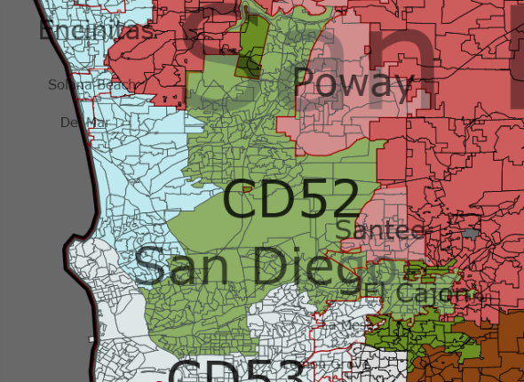
CA 52 Current Incumbent – none

Population – 706,873

White Black Asian Hispanic
Race 60% 5% 13% 17%
Obama McCain Kerry
Old District 45% 54% 38%
New District 56% 43%  
Change +11% -11% +18%

This is a Democratic district from North and East San Diego extending to El Cajon. 

CA 53 Current Incumbent – Davis (D-San Diego)

Population – 706,571

White Black Asian Hispanic
Race 46% 11% 10% 29%
Obama McCain Kerry
Old District 69% 30% 61%
New District 64% 34%  
Change -5% +4% +3%

This Democratic district includes portions of San Diego, Coronado, La Mesa, and Lemon Grove.

This is a majority-minority district.

By what margin will Bob Shamansky win?

View Results

Loading ... Loading ...

Contest Entry: 27-1 NY Map

This is my contest entry for Redistricting New York.

The aim of this entry was to create a map where 27 Democrats should be expected to win in New York in any given election. Every Democratic district is 53%+ for Obama. (Notwithstanding the astute observation by jeffmd that Presidential toplines don't mean everything) only 16 Republicans were elected in districts that Obama won by 53% or more (DE-AL, IL-06, IL-10, IL-13, IL-16, IA-04, LA-02, MI-06, MI-08, MI-11, NJ-02, OH-12, PA-06, PA-15, VA-10, and WA-08 [55% or more in bold]).

This entry respects VRA districts in New York City, puts King an a solid Obama district, and solidifies Democratic districts in upstate New York. 

Since New York is expected to lose one Congressional seat, one incumbent's district needs to be eliminated. Although the current Representative from New York 23 is a Democrat, I eliminated Representative Owens district and combined his home with Representative Murphy's NY-20. This map also shifts Representative Massa out of his district (represented here as NY-19). The reason for this is the location of his home in southeastern Steuben County. Steuben County is surrounded by Republican leaning counties, and a way to create a third solid Democratic district in Western New York is to connect Rochester and Syracuse.

Photobucket

Photobucket

Long Island

NY 1 Current Incumbent – Bishop

Population – 700,226

White Black Asian Hispanic
Race 77% 7% 2% 12%
Obama McCain
Old District 54% 44%
New District 54% 46%
Change 0% +2%

NY 1 becomes the southern half of Suffolk County.

NY 2 – Current Incumbent – Israel

Population – 700,711

White Black Asian Hispanic
Race 78% 7% 3% 10%
Obama McCain
Old District 56% 43%
New District 54% 46%
Change -2% +3%

NY 2 contains the central and northeastern portions of Suffolk County. This district remains potentially competitive, as the district vote for Obama was 53%.

Of all of the districts drawn on this map, this is probably the hardest one to justify – going from a district where Obama won with 56% in 2008. The only solace that I have is that a) Republicans rarely win districts where Obama won with 53% or greater, and b) there are plenty of Republican precincts in Nassau in Suffolk counties, especially along the border and along the northern shore. This, then requires a couple of decisions that need to be made. First, you could divide up Nassau and Suffolk counties east-west as exemplified by Answer Guy with a historical discussion here. Answer Guy's map divides Nassau into seven districts – each taking a portion of the Republican areas on Long Island.

NY 3 – Current Incumbent – None

Population – 700,454

White Black Asian Hispanic
Race 70% 13% 4% 11%
Obama McCain
Old District 47% 52%
New District 55% 44%
Change +8% -8%

Unlike other maps for this contest, I did not feel the need to split up Long Island – just moving the pieces around could create four Democratic-leaning districts (and BTW, and FWIW, WA 1 is connected by Ferry between Edmonds and Kingston).

This configuration of NY 3 draws Representative King out of the district. Even if he were to decide to run in the district, and not against Representative McCarthy in his NY 4, he would face a district where Obama received 55% of the vote.

The district is split into two areas, those parts of Hempstead adjacent to Queens and the portion of Hempstead adjacent to Suffolk County. The two areas are connected through Long Beach.

NY 4 – Current Incumbent – McCarthy

Population – 700,121

White Black Asian Hispanic
Race 77% 5% 9% 9%
Obama McCain
Old District 58% 41%
New District 54% 46%
Change -4% 5%

Photobucket

This is perhaps my ugliest looking district, but Representative McCarthy should be able to retain his seat under this configuration. The district encompasses the northern part of Nassau County, some Republican areas of Hempstead, and the North and West portions of Suffolk County. The district also extends into the Bay Side and Bay Terrace neighborhoods of the Queens.

If Representative King were to run for this seat, he would find its dynamics very unfavorable, with a lot of new constituents with a strong Democratic lean.

NY 5 – Current Incumbent – Ackerman/King

Population – 700,231

White Black Asian Hispanic
Race 54% 9% 20% 14%
Obama McCain
Old District 63% 36%
New District 60% 39%
Change -3% +3%

NY 5 could be considered a New York City district, as it stretches from the Bronx through Queens into North Hempstead and Republican areas of Hempstead (including Representative King's Seaford neighborhood).

New York City

NY 6 Current Incumbent – Meeks

Population – 700,218

White Black Asian Hispanic
Race 16% 51% 8% 16%
Obama McCain
Old District 89% 11%
New District 86% 13%
Change -3% +2%

This is a VRA district, and it does not change much from the current district. It does add all of the Rockaways.

NY 7 Current Incumbent – Crowley

Population – 700,095

White Black Asian Hispanic
Race 41% 9% 11% 34%
Obama McCain
Old District 79% 20%
New District 70% 29%
Change -9% +9%

Like the existing district, there are two distinct areas of the district. Instead of going North, NY 7 now orientates South, from Woodside and Hunters Point, through Ridgewood and Bushwick, and Woodhaven. From there, the district cuts into Jamaca Bay, Floyd Bennet Field and Marine Park to connect to Seagate, Coney Island, Brighton Beach and Manhattan Beach.

This is a minority-majority district.

NY 8 Current Incumbent – Nadler

Population – 700,295

White Black Asian Hispanic
Race 52% 11% 15% 20%
Obama McCain
Old District 74% 25%
New District 87% 13%
Change +13% -12%

NY 8 is now entirely a West Side/Lower Manhattan district.

NY 9 Current Incumbent – Weiner

Population – 700,395

White Black Asian Hispanic
Race 26% 11% 17% 42%
Obama McCain
Old District 55% 44%
New District 76% 23%
Change +21% -21%

NY 9 takes what was lost from NY 7 – crossing from the Queens into the Bronx over the Bronx-Whiteshone Bridge. The district is a minority-majority district.

NY 10 Current Incumbent – Towns

Population – 700,417

White Black Asian Hispanic
Race 24% 52% 4% 16%
Obama McCain
Old District 91% 9%
New District 84% 16%
Change -7% +7%

Photobucket

NY 10 loses the Willamsburg neighborhood and areas toward the west, and gains Republican areas in Manhattan Terrace. The district remains an African-American majority district.

NY 11 Current Incumbent – Clarke

Population – 700,102

White Black Asian Hispanic
Race 49% 15% 16% 16%
Obama McCain
Old District 90% 9%
New District 60% 40%
Change -30% +31%

The district extends from Representative Clarke's home precinct in Prospect Gardens in the north to Bath Beach in the south. While NY 11 is no longer an African-American majority district, it remains a minority-majority district. Because it takes in many of the Republican precincts in Queens, Obama's percentage in the district drops to 60%.

NY 12 Current Incumbent – Velazquez

Population – 700,391

White Black Asian Hispanic
Race 22% 50% 4% 20%
Obama McCain
Old District 86% 13%
New District 91% 9%
Change +5% -4%

NY 12 is now the second African-American majority district located entirely in the Queens. The district encompasses the Crown Heights and Prospect Heights neighborhoods as well as the Williamsburg neighborhoods. On the western edge of the Queens, a finger stretches south to pick up Representative Velazquez's home precinct in Carroll Gardens.

It is possible that neither Nydia Velazquez nor Yvette Clarke would be happy in their districts, since Representative Clarke will represent the more Hispanic-leaning district, while Representative Velazquez will represent an African-American majority district. However, this could be easily rectified. First, in my original map (before I learned what precinct each representative lives in), I had Representative Clarke in NY 12 (and she now is the Northernmost precinct of NY 11). Second, since Representative Velazquez is a renter, it is possible that she could subsequently move into the then open NY 11.

NY 13 Current Incumbent – McMahon

Population – 700,091

White Black Asian Hispanic
Race 67% 9% 6% 15%
Obama McCain
Old District 49% 51%
New District 60% 39%
Change +11% -12%

All of Staten Island remains in NY 13, and the district crosses into Brooklyn over the Verrazano-Narrows Bridge. From the bridge, the district heads north along the New York Bay into the Red Hook and Gowanus neighborhoods.

This composition makes the swing district a reliable Democratic district. Obama won 60% in this district.

NY 14 Current Incumbent – Maloney

Population – 700,256

White Black Asian Hispanic
Race 61% 8% 9% 19%
Obama McCain
Old District 78% 21%
New District 80% 19%
Change +2% -2%

NY 14 retains much of its current shape – although it does go a bit further north to encompass Rikers Island. Representative Maloney should be happy, as Obama won 80% of the vote here.

NY 15 Current Incumbent – Rangel

Population – 699,954

White Black Asian Hispanic
Race 14% 30% 3% 50%
Obama McCain
Old District 93% 6%
New District 91% 8%
Change -2% +2%

Photobucket

Charlie Rangel may face a stiff primary challenge in this district where Obama won 91% of the vote. The district loses portions of the Upper West Side for the Norwood and Olinville neighborhoods in the Bronx. The district does retain most of Harlem.

The district is a majority Hispanic district (just over 50%). 

NY 16 Current Incumbent – Serrano

Population – 700,580

White Black Asian Hispanic
Race 5% 30% 2% 60%
Obama McCain
Old District 95% 5%
New District 93% 6%
Change -2% +1%

60% Hispanic. 93% Obama. Not much more I can say about this Bronx district.

Upstate New York

NY 17 Current Incumbent – Lowey

Population – 700,687

White Black Asian Hispanic
Race 62% 20% 3% 12%
Obama McCain
Old District 62% 38%
New District 62% 37%
Change +0% -1%

Representative Lowey's district extends from the Bronx and follows I-95 and I-695 through Mount Vernon to the Connecticut border. To complete the district, NY 17 extends north along I-84 into eastern Putnam County and southern Dutchess counties.

NY 18 Current Incumbent – Engel

Population – 700,238

White Black Asian Hispanic
Race 70% 9% 5% 14%
Obama McCain
Old District 72% 28%
New District 58% 41%
Change -14% +13%

New York 18 extends into the Bronx to pick up Representative Engel's neighborhood of Fairport goes north through Yonkers into Westchester and Putnam counties. The District crosses the Hudson over I-87, and takes the Republican portions of Rockland and Orange County.

Engel's district takes a hit in order to strengthen Representative Hall. Obama's percentage in the district drops to 58%, which still should be a safe seat for a Democrat.

NY 19 Current Incumbent – None

Population – 700,409

White Black Asian Hispanic
Race 86% 6% 2% 3%
Obama McCain
Old District* 56% 43%
New District 56% 43%
Change +0% -0%

* Percentage for Representative Maffei's current district
Percentage for NY 29 = Obama 48%, McCain 50%

This configuration of upstate New York is necessary to preserve a 27-1 delegation. With Eric Massa's home in Corning in Southeastern Steuben County, the possible routes are to go north to Rochester, north and east to Ithica and Syracuse, or west towards Buffalo. None of these options make much sense and damage the possibilities of creating a Democratic performing district for Representative Arcuri's Utica based district because of the need to add population to NY 22 (or Maffei's Syracuse based district).

1) North to Rochester/Syracuse. This route is problematic for the creation of a sensible (to the eye) district for Representative Arcuri. Since in this formulation, his district spans I-90 and dives south to pick up Ithaca, any finger north puts pressure on Arcuri's district to ensure contiguity. (Also see MattTX2's entry for a good explanation of why going North does not work).

2) West to Buffalo. This route is more logical than going North, but has the effect of making NY 26 an eyesore, when it is possible to create a compact Republican performing district in Western New York and safer Democratic districts throughout upstate New York.

Instead, what I did was to create a district spanning I-90 from Syracuse to Rochester and Democratic portions of Ontario county, which is similar to the existing NY 25. In this district, Obama received 55% of the vote. As I suggested in the intro, 55% is really the safest magic number, with 7 Republicans representing districts 55% plus. Of those 7 Republicans, one Cao won because of scandal, two are in Illinois (where Obama is from), and one is a state institution (Castle). For me, the only head scratchers are the two Pennsylvania districts and WA-8 (but that is a different story).

To sum up, NY-19 is a very safe Democratic district and follows much of the current NY 25, even if it does not contain Representative Massa's (or Representative Maffei's) current residence. This does not pose a Constitutional problem, but long-term, is a relatively compact district that should safely elect a Democrat to Congress. In addition, if Massa is not able to win reelection in 2010 (rated lean Democrat by CQ; Kerry 42%, Gore 43%), the issue then becomes moot. However, since that is not part of the conditions of this contest, I choose to create a compact district between Rochester and Syracuse and elsewhere in upstate New York that are more consistently Democratic performing.

NY 20 Current Incumbent – Hall

Population – 700,079

White Black Asian Hispanic
Race 74% 10% 3% 12%
Obama McCain
Old District 51% 48%
New District 55% 44%
Change +4% -4%

Photobucket

Representative Hall's district, like most of the swing districts in upstate New York is strengthened. The district stretches from the northern portion of Weschester County (including Yorktown and New Castle) to a small portion of Ulster County and includes the Democratic parts of Rockland County and Orange County.

The district becomes a safe seat for Representative Hall, with Obama's percentage at 55%.

As an aside, I think this district looks like a M.U.S.C.L.E. Man, with its head in Ulster County, two arms going from Orange County to Dutchess County, and its two legs stretching into Ramapo and Yorktown and New Castle.

NY 21 Current Incumbent – Tonko

Population – 700,765

White Black Asian Hispanic
Race 89% 6% 2% 3%
Obama McCain
Old District 58% 40%
New District 56% 42%
Change +2% -2%

Photobucket

This Albany-centered district becomes less Democratic to shore up Representative Arcuri's seat, but the district should remain a safe seat for Representative Tonko.

In the Capitol Region area, the district loses Schenectady and gains Saratoga. Outside of the region, the district takes in Republican-leaning portions of Schohare and Greene counties, and Republican areas of Delaware and Ostego counties. Representative Tonko's residence in Amsterdam remains in the district.

NY 22 Current Incumbent – Hinchey/Massa

Population – 700,478

White Black Asian Hispanic
Race 88% 5% 2% 4%
Obama McCain
Old District 59% 39%
New District 55% 44%
Change -4% +5%

This district is drawn for Represenative Hinchey, but would be a good district for Representative Massa should Hinchey (72) retire.

The district stretches along the Southern border of New York from Hinchey's home town of Hurley to Corning in Steuben County. The district also encompasses the Southern portions of Tompkins and Cortland counties and, in the East, the City of Poughkeepsie. The performance of the district does drop to 55% – staying above the potentially competitive line.

NY 23 Current Incumbent – Murphy/Owens

Population – 700,469

White Black Asian Hispanic
Race 93% 3% 1% 2%
Obama McCain
Old District 51% 48%
New District 53% 45%
Change +2% -3%

New York 23 takes in many of the counties in the Adirondack Mountains in upstate New York and then follows the Vermont/Massachusetts border into Dutchess County. 

This district contains most of the current NY 20 and portions of the current NY 23 and 24, but still raises Obama's percentage from 51% to 53%. Most of the increase is due to losing Greene and Delaware counties, in favor of more reliable Democratic Franklin and Clinton counties in the North.

Both Murphy and Owens reside in this district, but this is necessary to create safer districts across the State.

NY 24 Current Incumbent – Maffei

Population – 700,386

White Black Asian Hispanic
Race 91% 4% 1% 2%
Obama McCain
Old District* 52% 47%
New District 55% 43%
Change +3% -4%

* Percentage is for the current NY 23
Percentage for the current NY 25: 56% Obama, 43% McCain

Photobucket

Instead of going east from Syracuse, as Maffei's current district does, this district goes North, picking up large portions of the current NY 23 (Oswego, Lewis, Jefferson, and St Lawrence Counties). This district is Syracuse based, both in population and possess a shared community of interest, with most of the district in the Syracuse TV market (or Watertown market, which overlaps with Syracuse anyway).

This configuration does suggest a swing, but increasingly Democratic district. Obama did get 55% in 2008, but it may have barely gone for Bush in 2004. Perot did well in this district in 92, probably getting close to 25-26% of the vote (compared to 16% in New York and 19% nationwide).

NY 25 Current Incumbent – Arcuri

Population – 700,483

White Black Asian Hispanic
Race 87% 7% 2% 3%
Obama McCain
Old District 50% 48%
New District 54% 44%
Change +4% -4%

Photobucket

District 25 becomes an octopus looking district that stretches from Democratic Schenectady to Democratic Syracuse and Ithaca in the east. The head of the octopus is Representative Arcuri's home county of Oneida. The district also picks up portions of Syracuse. Despite the uglish looking nature of the district, the district gains 4% for Obama from 2008.

The district contains all of Schenectady, Oneida, and Madison counties, as well as portions of Montgomery, Schoharie, Otsego, Cortland, Tompkins, and Canondaga counties.

NY 26 Current Incumbent – Lee

Population – 699,996

White Black Asian Hispanic
Race 94% 2% 1% 1%
Obama McCain
Old District 46% 52%
New District 44% 55%
Change -2% +3%

With this map, Representative Lee is the safest Republican in any of the New England states. This NY 26 takes in his home precinct of Clarence 22 in Erie County, and encompasses most of the Republican leaning counties in Western NY as well as Republican-leaning areas in Western Monroe county. The district is comprised of all of Genessee, Wyoming, Livingston, Yates, Schuyler, Allegany, Cattaraugus, and Chautauqua counties, most of Stuben and the Republican areas of Ontario counties.

NY 27 Current Incumbent – Higgens

Population – 700,487

White Black Asian Hispanic
Race 81% 14% 2% 2%
Obama McCain
Old District 54% 44%
New District 57% 41%
Change +3% -3%

Photobucket

In creating a Republican performing district for Lee, NY 27 is the most immediate beneficiary. NY 27 now is an entirely Erie County district, with the exception of the town of Newstead and parts of Clarence in the Northeast corner (NY 26) and the North and West portions of Buffalo (NY 28).

NY 28 Current Incumbent – Slaughter

Population – 699,977

White Black Asian Hispanic
Race 79% 12% 1% 6%
Obama McCain
Old District 68% 30%
New District 57% 41%
Change -11% +12%

Photobucket

Representative Slaugher's district stays similar in form to her existing district, but includes all of Niagara and Ontario counties and a large portion of Monroe County. The district does include most of Rochester. The Obama performance in the district drops, from 68% to 57%, but a Democrat should remain safe here.

Conclusion

I am proud of the map. Although not every Democratic incumbent may like the map, at least 24 of the 27 current Democratic incumbents will be very safe in every single election. Of the Democratic incumbents, every district gave Obama at least 53% of the vote. The only remaining potential swing districts are NY 1, NY 2, NY 4, NY 23, and NY 25. Of these districts, NY 23 and NY 25 are significantly safer than before, while NY 1, NY 2, and NY 4 are in Democratic leaning areas of Long Island (NY 4 has a significant presence in New York City as well).

I believe that preserving County and City lines are important to the districting process. Communities of interest should not be broken up whenever possible, and I tried to keep towns intact, especially in upstate New York.

To supporters of Representative Massa, I expect that he will succeed Representative Hinchey when he retires.

By what margin will Bob Shamansky win?

View Results

Loading ... Loading ...

Obama wins 28 districts in New York (Redistricting w/partisan data)

After seeing the addition of partisan data for New York, I decided to try my hand at creating a 28-0 map of New York (well at least a map where Obama won 28 districts in 2008).

From the outset, there are a couple of assumptions that went into the design. 

1) Keep intact county lines as much as possible.
2) Make it difficult for Republicans to win the district.
3) Ignore homes of incumbents (both R and D)
4) I also did not match up existing district numbers with the map

The top level description of the map is that I succeeded. In western NY, I grouped counties in an East-West manner, splitting Buffalo and stretching those districts from the Finger Lakes to Lake Erie. In eastern NY, I grouped counties North/South with Scott Murphy's District going from the Canadian border to Dutchess County. On Long Island, I split NY 2 to go East-West across eastern Suffolk and Nassau counties. 

In the end, I created 28 districts Obama won, with only four district where Obama won with 51% of the vote or less.

NY 2009,Redistricting


Long Island

NY 2009,Redistricting

The goal for Long Island was to create three Democratic performing districts in Suffolk and Nassau counties. To that end I was successful,  however, there are two or three Districts that in the wrong year, could flip to the Republicans. However, since Democratic performance has been improving in this area, it is possible that demographic trends will preserve Democrats in this area.

CD 1: (blue) Suffolk – 83% White 8% Hispanic
52-47 Obama

CD 2: (green) Suffolk, Northern Nassau –  81% White 8% Hispanic
52-47 Obama

CD 3: (purple) Suffolk, Southern Nassau – 76% White 11% Hispanic
51-47 Obama

CD 4: (red) South and West Nassau – 65% White 15% Black 12% Hispanic
57-42 Obama

NY 2009,Redistricting

I admit I am not familiar with the actual New York City area to make an informed observation about these districts, but I do preserve a number of minority-majority districts. Only the Staten Island district may flip in a bad year.

CD 5: (yellow) South Queens – 22% White 49% Black 14% Hispanic
81-18 Obama

CD 6: Central Brooklyn – 6% White 73% Black 14% Hispanic
95-4 Obama

CD 7: (grey) Northern Queens –  42% White 27% Asian 18% Hispanic
65-33 Obama

CD 8: Northern Queens, Extends into Kings – 29% White 15% Asian 8% Black 43% Hispanic
74-25 Obama

CD 9: Northern Queens Bronx – 8% White 27% Black 5% Asian 56% Hispanic
90-8 Obama

CD 10: (magenta) Western Queens, Western King – 28% White 29% Black 30% Hispanic
87-11 Obama

CD 11: Southern Brooklyn – 57% White 18% Black 10% Asian 10% Hispanic
58-41 Obama

CD 12: Central/ West Manhattan – 70% White 6% Black 8% Asian 12% Hispanic
82-16 Obama

CD 13: Lower Manhattan/Brooklyn – 53% White 6% Black 17% Asian 18% Hispanic
77-21 Obama

CD 14: Staten Island/Brooklyn – 63% White 6% Black 10% Asian 17% Hispanic 51-47 Obama

CD 15: Harlem/East Side – 21% White 27% Black 45% Hispanic
90-8 Obama

CD 16: (green) Bronx/SE Yonkers – 19% White 30% Black 41% Hispanic
85-14 Obama

Rockland, Westchester area

NY 2009,Redistricting

 I have three districts extending out of New York City into Yonkers and Rockland and Westchester counties. This arrangement is similar to, but expands upon the current map of the area. where both NY 17 and NY 18 extend into the City. 

In the existing eastern most district, NY 18, Representative Lowey has consistently won with over 65% of the vote (Bush/Kerry 58%) – this performance may go down with this map's NY 20. However, this is necessary to strengthen (this map's) NY 18 (Hall), where Obama would have a more comfortable victory. 

CD 17: Bronx, W. Westchester, SE Rockland – 64% White 12% Black 15% Hispanic
61-37 Obama

CD 18: (yellow) Orange, S Sullivan, S Ulster, N Rockland, Poughkeepsie –  79% White 7% Black 9% Hispanic
54-44 Obama

CD 20: (pink) Putnam, E Westchester, E Bronx 89% White
53-44 Obama

Upstate NY

NY 2009,Redistricting

Upstate New York keeps counties intact and create nine districts where Democrats should be expected to win in most elections. However, in the right circumstances several districts could flip. However, I expect that no conservative Republican could win in these areas – especially with the trends in New England in support of Democrats.

Unlike the existing map, I took a more radical approach to dividing the districts, weakening the existing District around Albany (Tonko) and around Binghamton (Hinchey). I support Murphy and Owens, as well as take out Lee. However, this map does not respect the residence of incumbents as Owens and Murphy are placed in the same district as well as Maffei and Arcuri.  

CD 19: (ugly green) Franklin, Clinton, Essex, Washington, Rensselaer (-Rensselaer), Columbia, Dutchess (most) – 89% White
53-44 Obama 

This is Scott Murphy's current district. I help him by extending the district all the way to the Canadian border, and the Democratic leaning counties of Franklin and Clinton counties.

CD 21: (red) Warren, Saratoga, Albany, Greene, Delaware (most), NE. Ulster – 88% White 5% Black
56-42 Obama

I take the Tonko's Albany based district, and go North to Saratoga and then South into Delaware and Ulster counties. The district also includes the City of Rensselaer.

NY 2009,Redistricting

CD 22: (brown) Chautauqua, Cattaragus, Allegany, S. Steuben, Chemung, S. Tompkins, S. Broome, S Delaware, N. Sullivan (includes Binghamton and Ithica) – 89% White
51-46 Obama

Of all the districts that undergo a change, perhaps the most radical change is to Hinchey's district. The district now spans most of New York's southern border, but expands North to take in the city of Ithica. This district is perhaps the toughest to defend in a wave election, but the Democratic strongholds of Ithica and Binghamton should prevent a Republican from staying in office long.

CD 23: (light blue) N. Broome, Chenango, Madison, Ostego, Herkimer, Fulton, Montgonery, Schoharie, Fulton, Hamilton, Onodaga (part) – 90% White
52-46 Obama

This is the district I had the most fun drawing – as it streches across most of Central New York, connecting Syracuse and Schenectady and into the Binghamton suburbs. This is a Democrat performing district, but would vulnerable in a wave election.

CD 24: (purple) St. Lawrence, Jefferson, Lewis, Oneida, Oswego, Onodaga (part) 91% White
50-48 Obama

Because I was not concerend about where incumbents live, I was able to create a Democratic leaning district in Northern New York. The district extends into the Syracuse suburbs to preserve a Democratic lean. 

NY 2009,Redistricting

CD 25: Onodaga (Syracuse and S), Wayne, Cayuga, Seneca, Yates, N. Steuben, Schulyer, N. Tompkins, Cortland 90% White
52-46 Obama

With the City of Syracuse divided between the 23rd and 25th, this district expands westward. In a wave election, a Republican could take the district, but turnout in Syracuse should prevent that.

CD 26: (dark grey) Monroe (most), Orleans – 76% White 13% Black 5% Hispanic 58-40 Obama

I make the Rocester area whole -but add in the more conservative Orleans county.

NY 2009,Redistricting

The Buffalo area retains the exsiting split – but both then stretch Eastward to take some of the rural counties in Western NY. Obama still won each of the districts with over 53% of the vote.

CD 27: S and E Erie, Wyoming, Livingston, Ontario – 85% White 10% Black 53-44 Obama

CD 28 – N Erie, Niagara, Genese, S Monroe – 84% White 8% Black 54-43 Obama

In conclusion, a 28-0 vote is possible, but because of the voting patterns in Central and Western NY, a 28-0 map will leave several Democrats vulnerable to a wave election, especially if one goal is compactness and the preservation of county borders. 

By what margin will Bob Shamansky win?

View Results

Loading ... Loading ...