As we all know, the GOP did very well in a lot of state-level races around the country, in addition to their big gains in the House. This was especially true in Michigan, where the Michigan House of Representatives flipped from D to R after a 20 seat Democratic loss, and the Republicans gained seats in the Michigan Senate, going from a 22-16 majority to a 26-12 supermajority. Republican gubernatorial candidate Rick Snyder won convincingly. And over on the Michigan Supreme Court, two GOP-backed candidates (one incumbent justice, one challenger to an incumbent recently appointed by outgoing Gov. Jennifer Granholm) won their races as well, turning a narrow 4-3 “Democratic” majority into a 4-3 “Republican” majority. (The races and the court are nominally non-partisan…but everyone knows.)
There has been much buzz about exactly what this complete GOP control of the redistricting process means for the reapportionment process. Given the fact that Michigan is home, I’ve been among those wondering just that. This is my attempt at a prediction (or two). As an added bonus, it is my first diary ever here at SSP!
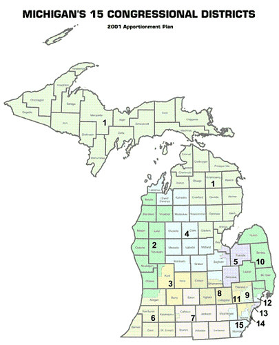
First, there’s the current map:
This is the 2001 apportionment plan based on the 2000 census. Like the forthcoming map, it was drawn when the state government was largely under Republican control (Legislature and Governor certainly were…I’m not sure about the MI Supreme Court at the time). As such, the map as it stands is already a GOP gerrymander, though it doesn’t look as obvious as, say, some of the districts in Pennsylvania ::cough::PA-12::cough::. This map flipped a 9-7 D-R delegation to 9-6 R-D. As with the 2000 census, Michigan loses one seat in 2010, down to 14 overall.
After the 2010 elections, we’re back from an 8-7 D-R map (Democrats flipped two districts in 2008) to a 9-6 R-D map. Districts 1, 2, 3, 4, 6, 7, 8, 10, and 11 will be represented by Republicans in the coming Congress; Districts 5, 9, 12, 13, 14, and 15 will be represented by Democrats. The only real change from 2000 is that District 1 is now in Republican hands and District 9 is in Democratic hands. As many of you know, the 9th (my district!) was drawn as a Republican district, but has trended away from the GOP and is now held by Democrat Gary Peters. District 1 was Bart Stupak’s district, which fell in the wave this year after he retired.
Obviously, if the Republicans want to try to protect all their incumbents, new and old, they will have to put two Democrats together to account for the loss of one seat. Much of the discussion I’ve seen has revolved around the idea that the Republicans are likely to match Gary Peters in the 9th and Sandy Levin in the 12th and either let them fight it out or encourage/force Levin into retirement.
I decided to explore the idea of such a match up to see exactly how it would impact redistricting throughout the rest of the state. Based on copious hours of work on the maps you’ll see below, a Peters-Levin match-up is eminently doable, but it will likely wreak havoc throughout the rest of the state for Republican incumbents. Although this seemed the most likely match-up to me, I’m starting to think that the GOP may instead try to pair John Dingell (MI-15) and John Conyers (MI-14), leaving Levin and Peters alone. I plan to explore that match-up another time.
Before we get to the maps, here are the principles I used in drawing them:
1. Wherever possible try to keep districts as compact as possible and without breaking county or municipal/township lines. This was not as high a priority as it otherwise might have been, as the Supreme Court is, IMO, likely to be a bit flexible with these requirements which are embodied in state law.
2. Keep each Republican incumbent in a single district, without matching them up with another Republican or forcing them to move. (While they obviously don’t have to live in the district, it always helps from a PR standpoint…)
3. Try to shore up shakier Republican districts.
4. Maintain two minority-majority districts based in Detroit (currently the 13th and 14th).
I used Dave’s App without using the “estimate new population” check box, as it had projected the state’s population to increase, rather than go down as it did. So, the current population figure on the app is actually closer to what it will be than the estimate. Obviously the population will change within the voting blocks, so take these maps with a grain of salt.
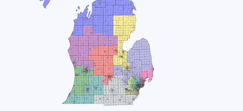
My first attempt at a Peters-Levin mash looked overall as follows:
Without the partisan numbers, I had to kind of eyeball the districts based on county-level returns and my own knowledge of the state. I figured the 2008 Obama numbers were the high mark in most counties since McCain basically gave up the state a month before the election.
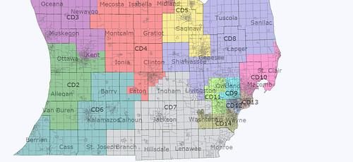
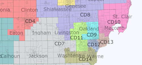
Here is the Lower Peninsula, and then a close up of the southern Lower Peninsula:
The first mash-up district I built more closely resembles Peters’ current 9th, but swoops south to take in Ferndale and Royal Oak (Levin’s home) in the southeast corner of Oakland County. The district surrenders its northern reaches (making Mike Rogers my Congressman…again) and West Bloomfield, becoming more compact, but probably more Democratic than it is currently. The district remains entirely within Oakland County.
As the maps show, though, this configuration likely causes chaos elsewhere. What was much of Sandy Levin’s 12th in southern Macomb (Democratic) has to go somewhere, and Candice Miller is unlikely to want all of it. So, the 13th, which will be held by incoming freshman Hansen Clarke, shifts a bit north from Wayne County. The district stays majority African American, but just barely. This pulls Candice Miller’s 10th south a bit, which costs her much of the thumb area. John Conyers’ district then shifts east a bit, but remains firmly African American majority. John Dingell’s district (now the 15th, here renumbered the 14th) is then pulled north out of swingy Monroe County and into friendlier territory in Wayne and Washtenaw Counties. Finally, Thad McCotter (MI-11) suffers as he picks up more Dem-friendly West Bloomfield in a mild attempt to keep his district compact.
Outside SE Michigan, things get even more interesting. I’ve pretty much concluded that Crazy Tim…I mean, Tim Walberg (MI-07) is stuck with a swing district unless the GOP folks in Lansing throw Mike Rogers (MI-08) under the bus and give Walberg all of heavily Republican Livingston County…which is where Rogers is from. So not happening. In this map, Walberg’s district shifts east, giving up more Dem-friendly Calhoun County (Battle Creek) and swingy Eaton County for swingy Monroe County and a slice of Livingston County. Calhoun County still has to go somewhere, and the only district really in the area is Fred Upton’s 6th. I doubt Upton will let this happen, as he already has heavily-Democratic Kalamazoo to contend with.
Likewise, someone needs to pick up Democratic Lansing and Walberg certainly won’t want it. Rogers seemed a likely contender at first (even though he wouldn’t want it either), but in the end his 8th District ended up (hideously, I must say) going east into the thumb area to pick up Candice Miller’s losses. (I tried at least 3 configurations to try to stretch Rogers’ district west and Dale Kildee’s 5th or Dave Camp’s 4th east into the thumb…I just couldn’t get anything that looked workable though.) This seemed like the best I could get, as ugly as it is. So, in the end the lucky winner of Lansing was Republican Dave Camp (MI-04). Camp’s district now occupies much of the farm country heartland of the state and includes his home in Midland, in an attempt to counterbalance Lansing. Dale Kildee’s 5th District takes in the Democratic areas in Flint, Saginaw, and Bay County, then stretches north to take in a few rural areas; I’d guess it stays firmly Democratic, though.
Finally, in the west and north, the 1st District which will be held by Republican Rep.-elect Dan Benishek shifts west and takes in Traverse City, probably shoring up the district for him. Republican Rep.-elect Justin Amash’s 3rd District gets a bold new look, but probably stays Republican, splitting urban Grand Rapids with the neighboring and still heavily Republican 2nd. (I realized after I finished everything that Amash may have to pick up and move a few miles after all, as I think I accidentally put him in the new 2nd with fellow Republican freshman Bill Huizenga. Oops.) The new 2nd, instead of stretching up the Lake Michigan coast, consolidates ruby red Ottawa County with southern Kent County (Grand Rapids) and areas further south.
Given the chaos that such a map could cause, I knew that it was unlikely that the Republicans in Lansing would try this. Even if they managed to tweak things (say, finding a way to stretch the 4th or 5th into the thumb instead of the 8th), having a Peters-Levin mash-up with a 9th District as I’ve constructed it here could cause too much of a headache to be worth the trouble. The real problem seemed to be with the shift in the districts caused by the leftover Democratic-leaning territory in southern Macomb, which is currently in Sandy Levin’s district.
I think the bottom line is that the current map is already close to an effective Republican gerrymander as you can get. There are islands of Democratic strength, especially in SE Michigan and sprinkled across the rest of the state that make it hard to make the Republican incumbents much stronger without hurting a fellow Republican. Without threading the needle precisely, the whole house of cards could end up collapsing in a Dem-friendly year, wave or no.
My next set of maps for Part 2 of this diary (to be posted within the next couple days) looks at a Peters-Levin match up in a district that looks more like Levin’s current 12th, rather than like Peters’ current 9th. The results were a little more encouraging for the GOP, but still caused problems that make me think they won’t go for that either. I’ll leave you all with that as food for thought until next time.


I agree with your bottom line assessment that this map wouldn’t be very attractive to the linedrawers in Lansing, but it’s a good effort with several creative elements.
I also agree with your conclusion that the Republicans have an extremely difficult challenge facing them. They’re maxed out already, and it’s going to be hard for them to maintain their existing position, let alone improve on it.
You already did a great job analyzing your own map and pointing out its weaknesses. I appreciate that level of realistic self-critique — a lot of us would-be gerrymanderers fall too deeply in love with our own handiwork.
More specific comments:
1. I’m not sure that using the 2000 data is actually a better choice than the 2008 data. The 2010 top-line number is obviously very different from expected, but the 2008 data would be helpful for trying to capture the impact of population shifts within the state. The population loss is expected to be concentrated in Wayne County, while the Grand Rapids-Holland area has grown.
2. I’m expecting that Levin’s district is probably going to be the one that’s going away. I’m also expecting that Dearborn will end up in Conyer’s district. However, even though the 15th as a number is going away, an equivalent to the western Washtenaw – southern Wayne district will still exist. So I imagine that Dingell will run in that district even if Dearborn isn’t in it.
3. I think your 4th district is particularly suspect from a Republican point of view. That territory north of Lansing was actually pretty good for Obama. Transferring Lansing from the 8th to 4th seems like a promising idea, but I’d want to make sure that it was counter-balanced with one of the really Republican counties nearby, like Barry.
4. Did you actually split Grand Rapids proper? That would be pretty suspect under the Apol standards.
5. In Oakland County, you’re wasting Rochester/Rochester Hills (and to a lesser extent Troy) in a Democratic district. You could swap in West Bloomfield into the 9th, moving Rochester/Rochester Hills into the 8th, and Highland/Rose/Springfield/Independence Townships into the 11th. (Under 2000 data, at least)
All in all, though, a great diary, and I look forward to your next installment.
and I think its got some great points. A good starting point. The GOP has some interesting challenges ahead of them. Some general notes and comments
1. I am convinced that Chairman Camp (Ways & Means)-Chairman Upton (Energy & Commerce)-Chairman Rogers(Intelligence) will be accomdated. Congressman Tim W. might be improved a bit but he will not improved at the expense of the three chairman.
2. The GOP will naturally have to work around Ann Arbor and East Lansing plus the rules on not splitting counties makes a few compromises inevitable. On a geographic note the GOP needs to figure out how to shoot McCotter into Oakland county from Wayne so some sort of basic plan like this could do.
I like your arrangement in MacComb county plus the dip into it from Wayne county for one of the AA seats. Plus the Levin/Peters combo is the likely matchup. Dingell gets a safe seat as who wants Ann Arbor?
The question is the “Thumb” area and how the GOP not waste all of that area on Kildee. Yes you can do the Rogers under and over plan as you did it. That could work but then who gets East Lansing. I think Camp would freak with your plan. He might hold the seat once but he would face constant battles for the seat. There was a previous over Sagninaw plan. I like that idea.
Here’s a basic sketch–Miller gets a little over 1/2 of St Claire–the balance of that county plus Lapeer gets added to Genesee. Then Kildee gets 60% of Sagninaw. Camp gets the balance of Sagninaw plus the three thumb counties.
Then Rogers keep Lansing area-Livingston plus a piece of Oakland. That’s my thinking of GOP plan.
it is practically a foregone conclusion that they will combine Peters and Levin in a heavily Democratic Oakland/Macomb seat, expanding Conyers’ and Clarke’s district to pick up mostly black areas that had been in Levin’s district and giving Peters’ GOP voters to McCotter. I’ve tried Michigan on Dave’s Redistricting and it seems pretty easy to do that – create five deep blue Dem seats and nine Republican leaners.
Weird to think Dem-leaning Michigan could have the exact same partisan split (9-5 GOP) as conservative Georgia in 2013 (that assumes the courts prevent Republican mapmakers from cracking Barrow’s arguably VRA-protected district).
Will Michigan Dems be willing to say goodbye to one of them? Or do they really want to throw Peters under the bus? I know Dingell has been in Congress forever (at least it feels like it!). And hasn’t Levin been in Congress for quite some time as well? Conyers has a strong reputation among progressive activists and netroots folk nationally for his work on single-payer health care and justice issues, but are the good vibes also felt at home?
The Detroit area stuff looks ok for the most part, but you stuck Camp with what looks like the most Dem-leaning parts of D+13 Ingham county, with only a bunch of smaller and not very red counties to compensate. Midland and Ionia are both R+5 and about half the size of Ingham combined. Eaton is D+0 or D+1 and it looks like you gave Camp the more liberal parts of it. Clinton is R+3, Gratiot R+1, Montcalm and Mecosta R+4. Isabella is D+6 thanks to CMU. The district looks tailor-made for a Lansing-area Dem and I don’t think Camp would have much of a chance. I think the Reeps would definitely protect the head of the Ways and Means committee and certainly would not help the weak Walberg at his expense.
I don’t think Amash could win that new district you gave him either. He comes across as sort of a Pat Toomey type who probably needs all the suburbs he can get. It looks like you took away about half of his Kent county suburbs plus R+4 Ionia and R+8 Barry and stuck him with D+11 Muskegon and a bunch of marginally red rural counties: Oceana R+1, Newaygo R+6, Mason R+1, Lake D+3, Osceola R+9, Clare R+1, Gladwin R+3, Wexford R+6. The old 2nd district worked for Reeps because it had R+15 Ottawa to outweigh the smaller Muskegon. Your new 2nd is a red fortress, and your 3rd a pure swing district.
While this looks like a potential winner, some caveats are in order. First, the Apol standards would require Grand Rapids be kept whole. This would be along the lines of a dubious achievement. Pairing Grand Rapids and northern Kent Co with Muskegon would actually tip the district in the D favor, putting two Democratic strongholds together.
Second, as the Af-Am community is split between Grand Rapids and Kentwood, such an arrangement would be open to challenge under the voting rights act. It’s hard to see how you get away with splitting the two. Also on this, as Kent County has one of the highest concentrations of Hispanics in the state, splitting that community (Grand Rapids / Wyoming) would also likely face challenge.
Finally, there is a political reality. Bill Huizinga (R, MI-2) and Justin Amah (R MI-3) would be both be in the same district, Huizinga living in Ottawa, Amash in Cascade — both in the configured Third. We can safely say, THAT is not going to happen.
The map does point out the challenge Republicans face in the West. The bulk of urban Kent County will have to be kept intact (see above, voting rights), and with Kent County pushing over 630,000 this leaves little in the way of reinforcement for the conservative nature of Amash. A creative way would be to extend the third west to Sagautuck — essentially picking up the top tier twps of Barry County. That would give the district a distinct rightward shift, while allowing Upton to pick up more of Barry to offset liberal Kalamazoo.
Another great Michigan redistricting map. I live in the 6th, and Upton has nothing to worry about right now. He’s always won Kalamazoo County, even when the suburbs and some of the rural areas like Oshtemo started throwing it to Dems starting in state elections in the 90’s. The problem for Republicans will be when he retires. If I were a smart Republican, I’d be happy that Republicans swept the local races this year in SW Michigan so Democrats didn’t build up a strong bench; Upton’s district is a lot less Republican then it appears since Berrien County has a large black base in Benton Harbor that rarely votes but came out in large numbers in 2008 and Van Buren and Cass, though quite rural, both have areas of Democratic strength. Putting Calhoun with Kalamazoo County would be a dummymander time bomb.