The Knollenberg Project: Michigan Congressional Redistricting

Conventional wisdom regarding Michigan’s congressional redistricting process to this point has looked towards the state Republicans dealing with Michigan’s lost seat by consolidating Sander Levin and Gary Peters into a single district. Two relatively new sources of information are challenging that wisdom.

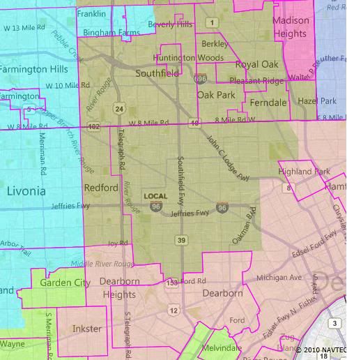
First, the actual census numbers came out. And the beating that Detroit took over the last ten years was a lot worse than generally thought. As best as I can tell, it’s no longer possible to draw two majority-black congressional districts in Wayne County. Instead, whichever district is centered on western Detroit is going to have to crossover into southern Oakland County to pick up, at the very least, the city of Southfield. Which suggests the option of having that district scoop up as many white Oakland County Democrats as it can, since it’s in the neighborhood anyway. Which in turn suggests that the relevant pairing is going to be Levin-Conyers, not Levin-Peters.

Second, per a recent digest, state representative Marty Knollenbeg, a member of the redistricting committee and son of Peter’s predecessor, has moved from talking about challenging Peters in 2012 to actually starting the machinery of his campaign, in the form of an exploratory committee. That suggest that Knollenberg thinks Peters (or at least the bulk of Peters’ district) is going to be in such a form that it would be amenable to electing a Republican. Which again cuts against the Levin-Peters pairing.

So: If there’s a district for Knollenberg, some other district is still geting cut. Maintaining two VRA black districts requires one of the Detroit districts to cut into Levin’s Twelfth. Putting that together, perhaps the Twelfth is the district to go? What would that look like?

I explore three possible solutions after the jump.
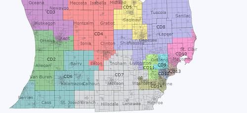
Common Threads

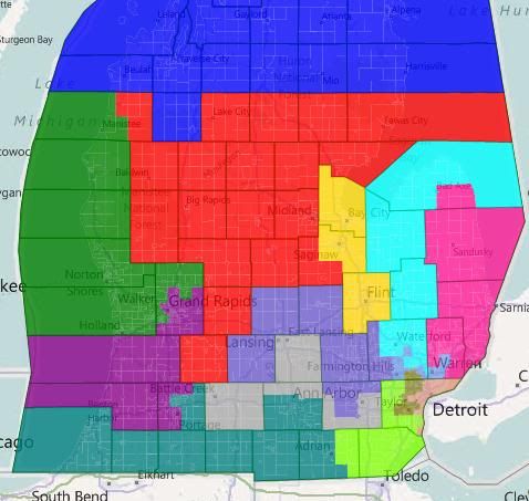
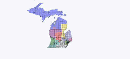
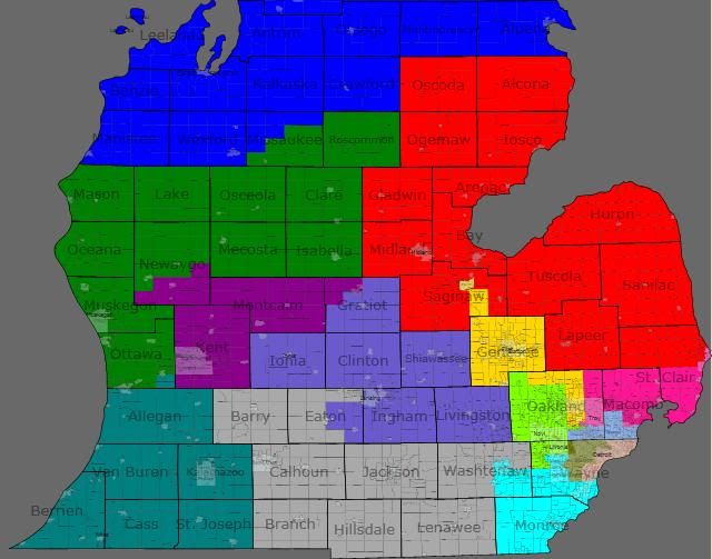
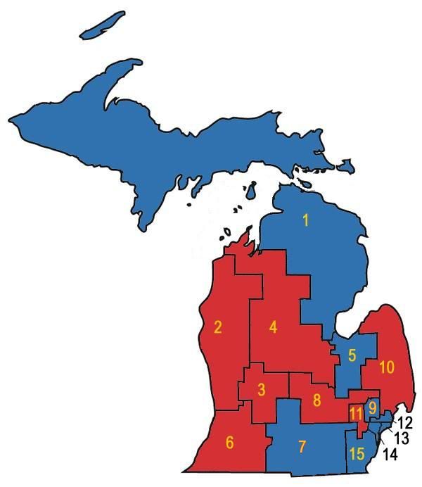
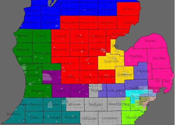
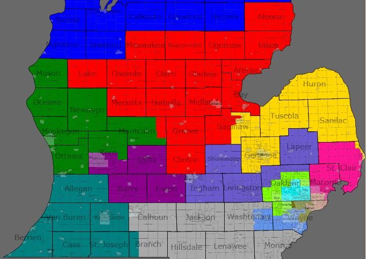
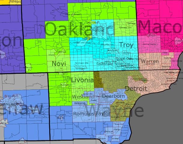
All three of my solutions have six districts that are identical: MI-01, MI-05, MI-09, MI-10, MI-13, and MI-14. The new MI-12, which is now the designation for Dingell’s district, stays more or less in place for all three maps also. Here’s the process by which those six districts were built.

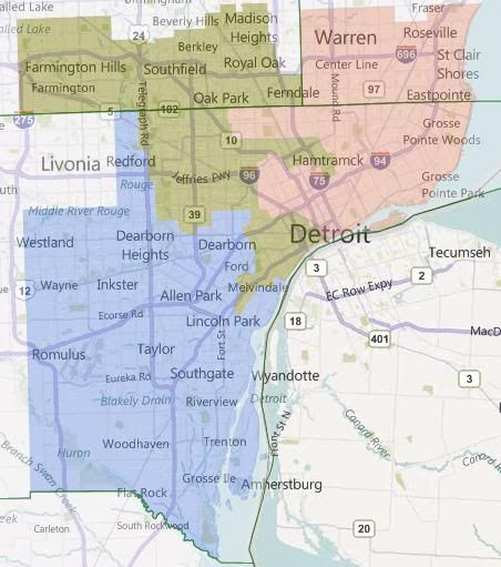
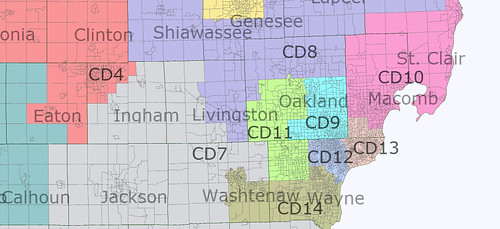
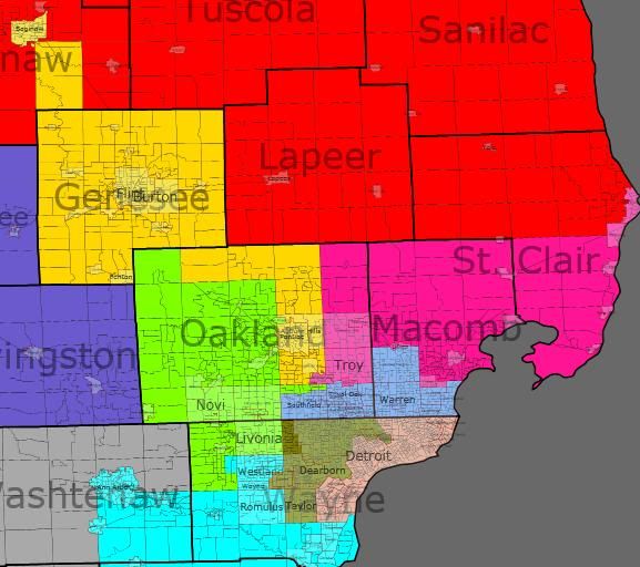
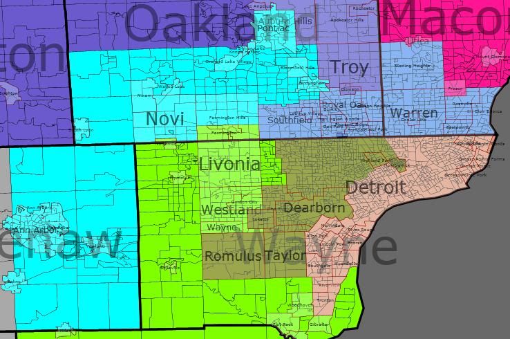
First, the inner Metro Detroit districts. Basically, all three of these maps are looking at scenarios where MI-14, based in western Detroit, takes in the western (Oakland County) portion of the dismantled MI-12, while MI-13, based in eastern Detroit, takes in the eastern (Macomb County) portion of the dismantled MI-12.

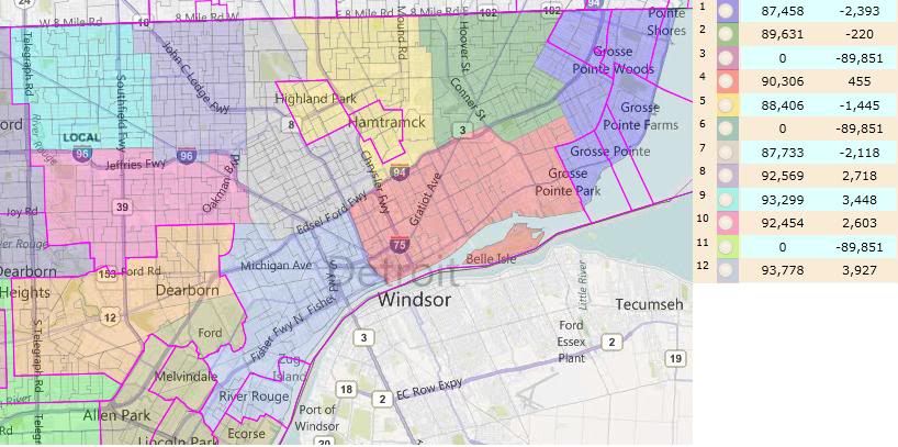
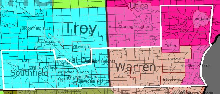
The particular version stretches MI-13 to its breaking point — it’s almost literally 50%+1 black by VAP. (It’s 50%+218.) It takes in heavily Democratic Warren, Eastpointe, and Roseville, along with not quite so Democratic St. Clair Shores. (I’m realizing now that I should look at scenarios where St. Clair Shores is in MI-10.) It’s forced into taking the Grosse Points and Harper Woods, and after that it can’t take any more non-black population. That’s why MI-14 has the odd arms to take in white Hamtramck and hispanic southern Detroit.

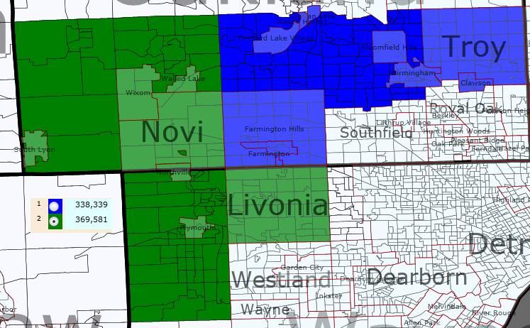
Besides those arms, MI-14 takes in the rest of Detroit, and then moves north in Oakland County, taking in Southfield for its black population, and the spreading east and west to take in the most Democratic parts of southeastern Oakland. It can’t quite do this cleanly, the little city of Clawson ends up split between it and the undrawn MI-09.

MI-12, having been dismantled, is then reborn as the designation for Dingell’s district. It takes in the most Democratic of the Wayne County suburbs, leaving the western tier of townships for McCotter (or at least he hopes so). Note that dismantling and relocating MI-12 in this way prevents Dingell from hanging on to Ann Arbor, which is going to be problematic for the Republicans later.

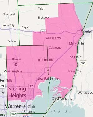
Then MI-10. It takes up the rest of Macomb, and then fills its balance by taking in as much of St. Clair County as it can. There’s been significant population growth in St. Clair and northern Macomb. This, combined with the fact that MI-13 isn’t taking in all of the old MI-12’s portion of Macomb County, causes Candice Miller to lose most of her Thumb Counties.

Obama won Macomb County by about a 36k margin. Warren by itself accounts for about 13k of that margin. The rest of MI-13’s part of Macomb County is about another 15k. That means that the rest of the county went for Obama by about an 8k margin, out of about 285k total votes (for the rest of the county.) Obama won the part of St. Clair County that’s in this district by about 3k out of 72k. That adds up to Obama winning this district by 11k out of 285k total votes. That’s not going to be as comfortable as for Candice Miller as her current R+5 district, but it should be manageable.

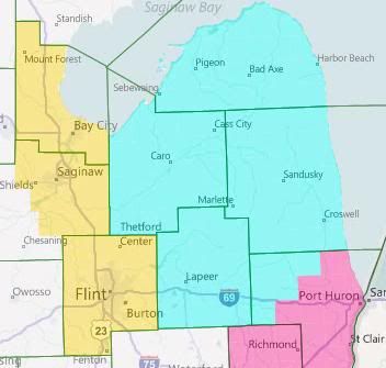
And now the Thumb. The Thumb Counties proper are fairly Republican, so I’m assigning them to our rebuilt MI-09 (which will also be taking in a good part of Oakland, as you’ll see later). That implies the assigned shape for MI-05: Gennessee and Bay Counties plus the most Democratic parts of Saginaw County that will fit.

Which in turn implies this shape for MI-01. Having been kicked out of Bay County by MI-05, it needs to pick up population somewhere, and adding Republican Grand Traverse County to it will help anchor it for Benishek. One goal going forward is to keep that move from harming Dave Camp too much.

Okay, so with those 5-6 district set in place, what sort of options do we have for the others?

Interlude

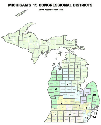
The current Republican map of Michigan has some very finely wrought pieces. In particular, they went out of their way to make sure that most of Michigan’s Democratic-leaning cities in the outstate ended up in separate districts where they could be drowned out by rural and exurban voters. The cases in point: Muskegon in MI-02, Grand Rapids in MI-03, Kalamazoo in MI-06, Lansing in MI-08. MI-07 was such a case when it was created, keeping Battle Creek safely away from more Democrats (Jackson, so far as I can tell, is swing-tilt-Republican); but Lansing’s western suburbs in Eaton County have blued significantly over the last decade. They then decided that Flint-Saginaw-Bay City was too dangerous to crack, and also packed in Ann Arbor with the southern Detroit suburbs.

This analysis is important because, while we’ve maintained the packed district for Flint, we weren’t able to maintain the Ann Arbor to Dearborn packing. And none of the outstate districts can afford to take on Ann Arbor in addition to the existing Democratic city that they’re warding. The upshot of this is that if Knollenberg is successful at getting a seat made for himself, and if I’m right that Levin’s is then the disappeared seat, then Knollenberg is going to be creating a seat for himself at some other Republican’s expense.

Said another way, the current breakdown of the delegation is nine Republicans and six Democrats. One seat needs to go away; the Republicans obviously want it to be a Democratic one. In addition, Knollenberg is trying to flip a Democratic seat into a Republican one. That would make the delegation 10-4. I submit that it’s impossible to make a map of Michigan with only four districts that are Democratic. 9-5 is the GOP max. Since there are 9 Republicans already, adding another one to the delegation necessarily involves booting an incumbent.

In all three of my sample maps below, that person is Tim Walberg. This is because he is (1) a freshman who is (2) out of step with his swing district which can (3) be made into another MI-05-esque medium-sized-city Dem vote sink. The three options are named for the cities that the new MI-07 covers.

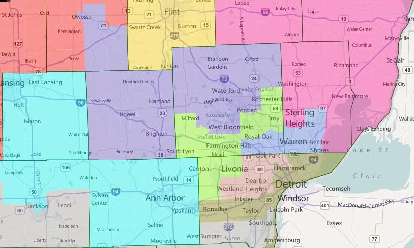
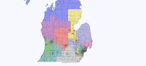
Option 1 — Ann Arbor, Battle Creek, Delta Township

Option 1 has MI-07 cover central Michigan from Ann Arbor to Battle Creek, with an arm reaching out to take in the western suburbs of Lansing.

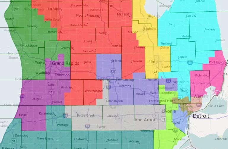
In the west, MI-02 subsumes deep blue Muskegon and the swingy coastal counties with deep red Ottawa and north Kent. (Although not picture, MI-02 takes in all of the coastal counties up to Leelanau. MI-04 has the interior counties that aren’t in MI-01.) MI-03 takes a third of a turn clockwise, dropping Ionia and most of Barry to grab Allegan and Van Buren. Camp’s MI-04 replaces its loss of Republican Grand Traverse with very Republican Ionia and Barry.

Upton’s MI-06 now stretches across southern Michigan, where he picks up an unwelcome constituent in Tim Walberg. Rogers in MI-08 is left to hold down more-or-less the same district that he has now.

Finally, there are the two metro Detroit districts. Knollenberg here adds the northwestern third or so of Oakland County to the Thumb Counties to make the new MI-09, resulting in a reasonably Republican district, even if he’s still holding onto Pontiac. McCotter actually gets shored up here, I think. He picks up Democratic West Bloomfield but loses the most Democratic parts of his current district, which I think balances out in his favor. He also gains Monroe County, which I’m under the impression is swing or lean-Republican these days.

Overall, I think this is the best of the three options for the Republicans. One problem is that having two Oakland-Wayne districts probably violates Michigan’s redistricting standards. That’s more of a political problem than a legal one, though.

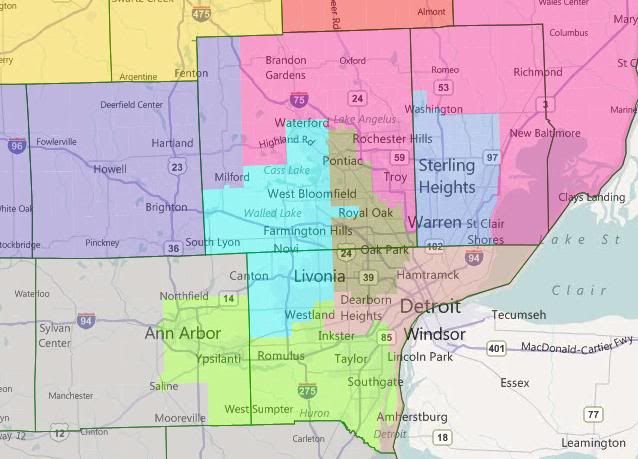
Option 2 – Ann Arbor, Battle Creek, Lansing

Option 2 has MI-07 cover central Michigan from Lansing to Jackson, with obviously-gerrymandered-yet-Michigan-standards-compliant arms to pick up Battle Creek and Ann Arbor-Ypsilanti.

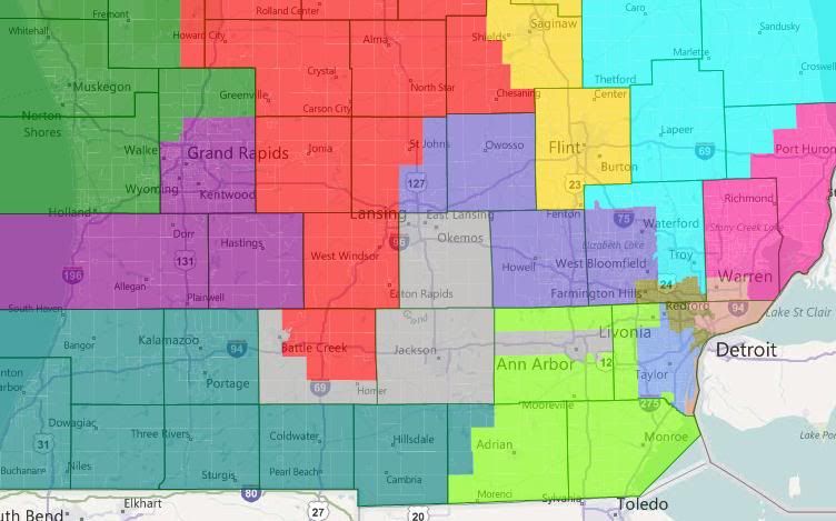
Off-screen, MI-02 has picked up Wexford, Lake, and most of Newaygo Counties from MI-04, which is has in turn picked up the rest of Eaton and a big chunk of Calhoun. This is bad for Dave Camp. In other news worth mentioning, Walberg is now McCotter’s problem — although the massive amounts of Washtenaw he also picks up are an even larger problem. If I recall some math I did the other day, if you exclude Ann Arbor, the rest of Washtenaw voted 2-1 for Obama. Excluding Ypsilanti also helps, but not that much.

Overall, this map is better for Upton, Amash, and Rogers; and worse for Camp and McCotter.

Option 3 – Battle Creek, Kalamazoo, Lansing

Option 3 has MI-07 cover central Michigan from Lansing to Kalamazoo without dealing with the Ann Arbor problem.

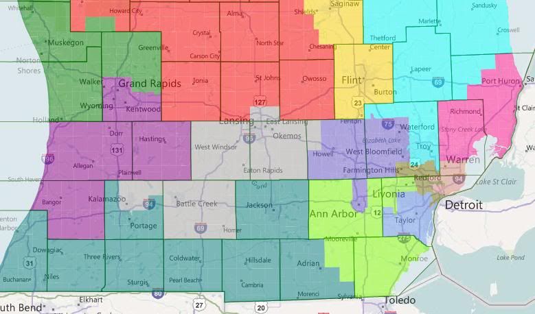
Offscreen, we’re back to the arrangment of the first map — coastal = MI-02, interior = MI-04. Walberg is back to being Upton’s problem — but he’s also lost Kalamazoo, so that’s a legitimately Republican district now. Amash and Camp should both be happy. (Amash’s district in this arrangment, incidentally, is at zero-deviation from ideal.) Rogers should be okay — taking in Ann Arbor for Lansing-East Lansing should balance out. But McCotter’s still in trouble — again, even without Ann Arbor, Washtenaw is a 2-1 Obama jurisdiction.

Bonus Option

As I was writing the diary, I had the inspiration for a pro-Knollenberg, anti-Walberg map that cut out Dingell instead of Levin. MI-13 is 52.2% black VAP, MI-14 is 53.4% black VAP. Here it is without further commentary, because I need to get myself to bed.

Michigan State House Redistricting, Part I

This is first in a series of diaries looking at redistricting in the Michigan State House. I’m not totally sure how many parts there will be yet. The current diary is focused on Wayne County, home of Detroit, and the county with the worst numerical net loss of population over the last ten years of any in the country — just short of a quarter million.

The upshot here is that Wayne County currently possesses 23 state house districts; with the population loss, it’s going to drop to 20. All three seats loss are Detroit-based.

Michigan has a 110-member state house. In 2010, the Republicans gained nineteen seats while losing none, to take control of the chamber by a 63-47 margin.

I haven’t done a full map yet, so I don’t know for sure where those seats are going, but I have to assume that the loss of three safe seats in Detroit is going to make the task of regaining the chamber even more difficult for the Democrats.

Maps and more after the jump.

Note: ideal district size is now 89,851 people. The allowed deviation is 5%, I believe, which translates to 4492 people.

Old Districts

Here’s an approximation of the current districts based solely or partially in Detroit in Dave’s App:

Notice how under-populated the Detroit-based districts are. HD-01 (Grosse Pointes) is majority white; HD-12 (Southern Detroit) is majority Hispanic (total population, just short on VAP); the rest are majority African American. HD-01 is the only competive district, going 54-46 Democratic in 2010. The rest are safely Democratic.

Here’s the approximation of the rest of the county’s districts:

I lightened the colors to make the locality boundaries stand out. This obscures, to my vision, one of the district boundaries. The boundary between HD-14 (Northern Downriver) and HD-22 (Romulus/Taylor) is the Taylor/Allen Park city line.

Surprisingly, to me, there are actually four districts that are overpopulated; three of which are outside the allowable deviation. HD-21 is going to have to be broken up — that’s a really significant positive deviation.

Republicans hold three of these seats: HD-19 (Livonia), HD-20 (Plymouth/Northville), and HD-23 (Southern townships). Of the remaining seats, only HD-21 is competitive. The Democrats held on in 2010 by 51%-49% – about 900 votes. All of these seats should be winnable by the right Democrat in the right environment — I’m pretty sure, for example, that Obama carried every Wayne County district. Also, I’m reasonably certain that HD-20 would have the most Republican PVI, and it was a 2010 pickup for them.

Collectively, the Wayne County districts are 246k underpopulated. The twelve Detroit-based districts account for all but .8k of that shortfall. (That is, the number of non-Detroit-based districts is the same. All of the districts lost in Wayne County will be Detroit-based.)

New Districts

Michigan redistricting standards encourage linedrawers to maintain the integrity of localities where possible. This is the arrangement that I came to while redistributing the eleven non-Detroit-based districts within the limits of that guideline, while trying to protect the three Republican incumbents.

HD-23 (Southern townships) and HD-13 (Southern Downriver) are the only truly clean districts, with Gibraltar having been swapped from the former to the latter.

HD-21 needs to be broken up. Plymouth, Plymouth Twp, Northville, Northville Twp, Canton and Wayne combine to within 4k of the ideal for two districts. A real Republican plan would take into account how best to split Canton to their advantage; my selection of precincts to end up in HD-20 and HD-21 was arbitrary. HD-21, however, should end up more Republican than before: Van Buren Twp and Belleville together are both more Democratic and larger than Wayne.

Livonia and Dearborn are each slightly too large to be single district. I maintained Livonia’s current donation to HD-17, Dearborn ends up donating into HD-14 (Northern Downriver) instead of into Detroit. This is because HD-14 was too large with River Rouge (which therefore ends up in a Detroit-based district) but worked with the donation from Dearborn.

With Van Buren/Belleville bounded on the north by HD-21 and on the south by HD-23, the only place for them to go was into HD-22 to the east. This required Romulus and Taylor to split. I ended up combining Romulus/Van Buren/Belleville with Inkster and enough of Westland to connect them (the portion south of Garden City and east of Merriman Rd), thereby creating an African-American opportunity district. (It’s W 46.8, B 44.9 by total pop; W 50.7, B 42.4 by VAP.) Taylor then combines with the portion of Dearborn Heights south of Ford Road to make HD-16.

The final two districts are then HD-18 (Garden City and the portion of Westland west of Merriman Rd) and HD-17 (Redford, the part of Livonia not in HD-19, the part of Dearborn Heights not in HD-16, and the part of Westland not in HD-18 or HD-22).

The Detroit-based district here are more representative than predictive. I don’t know enough about the incumbent representatives to know which the Republicans might favor or disfavor through redistricting. But you can see in general terms what Detroit looks like with three fewer districts than before.

HD-01 is still majority white, although slightly less so. (It should therefore become less competive for the Republicans.) HD-12 is no longer majority Hispanic. It previously contained every heavily-Hispanic precinct it could; its necessary growth diluted the Hispanic percentage down to 44.5% by total population and 39.2% plurality by VAP.

Conclusion

Republicans could potentially net as many as four state House seats in Wayne County from their control of the redistricting process: the three that are disappeared from Detroit (depending on where they end up) and HD-21, a competitive seat that will be somewhat less Democratic than before.

Michigan Redistricting: An Unexpected Problem

Maintaining two VRA majority-African-American districts in the metro Detroit area is going to be much more of pain than I originally thought. In the relevant population by CD thread, I breezily commented:

And, on an even more important “not-to-mention” note, the Detroit metro area still has more than enough African Americans for two VRA districts, so consolidating MI-13 and MI-14 isn’t in the cards quite yet.

This is not untrue, but the measures required to get those two districts were a lot more dramatic than I expected. The most recent Census estimates painted a very different picture from the actual Census’s report of massive population loss in Wayne County. And so the new districts are likely to be quite different from what I (and others) had previously imagined.

After the jump, I present two different scenarios for the Detroit area districts. Please feel free to post your own — this is very much more about getting a discussion going than presenting anything close to a polished proposal.

Map 1: Skirting the Line

So far as I can tell, this is the best you can do in terms of maximizing the African American percentages of the two Detroit districts while staying in Wayne County. However, the two Detroit districts are majority African American by total population, but not by VAP. So to the best of my understanding of current case law, this solution is VRA-suspect.

Which is unfortunate for the GOP, because this is reasonably successful map for them. Basically, this is an attempt to cut out both Dingell and Peters, while replacing one of their districts with a new safe Ann Arbor plus Lansing district.

District-by-district, briefly:

Benishek’s MI-01 (Blue) is shored up for the Republicans with the addition of Grand Traverse County. Likewise, Upton’s MI-06 (teal) gains Allegan County. Amash’s MI-03 (purple) holds more or less steady, as does Miller’s MI-10 (pink).

Huizenga’s MI-02 (green) – currently the most Republican district – absorbs a couple of problematic counties from Camp’s MI-04 (red). MI-04 is a little shaky for the Republicans, but I’m not sure how to fix that.

Walberg’s MI-07 (grey) loses Eaton and outer Washtenaw County and picks up Monroe County and the southern tier of Wayne County – I could be wrong, but my instincts tells me that’s a wash. Kildee’s MI-05 (yellow) stretches north to take in more of the Thumb and all of Bay County, which marginally weakens it for the Democrats. MI-09 (cyan) is a new heavily Democratic open seat stretching from Ann Arbor to Lansing.

Then, we move into the Detroit Metro area. Massive population loss in Detroit causes Conyer’s MI-14 (brown) and Clarke’s MI-13 (salmon) to chew up most of the Wayne County portions of Dingell’s dismantled MI-15. They’re 50.6% African American total pop, 49.6% VAP and 50.3% African American total pop, 49.5% VAP respectively. Levin’s MI-12 (cornflower blue) stays more or less the same, picking up the rest of Royal Oak from Peter’s dismantled version of MI-09.

Speaking of which, that’s been bisected between McCotter’s MI-11 (lime) and Rogers’s MI-08 (slate blue). McCotter picks up Peters himself and some of the more Republican parts of the dismantled Ninth. Rogers gets some of the most Democratic parts of the old ninth in West Bloomfield, Pontiac, and Auburn Hills — but he no longer has to worry about Lansing, so he should still be fine.

Map 2: The Problem of Pontiac


Same thing, just zoomed in with locality lines

This one really just focuses on the two Detroit districts. In contrast to the first map, you’re looking at two true majority African-American districts. MI-13 (salmon) is 53.0% African American on both measures. MI-14 (brown) is 56.5% African American by total population, 54.6% African American by VAP.

So far as I can tell, stretching Conyers’s district over into Oakland County like this to pick up Southfield and Oak Park is the only way to get the two Detroit districts to combine into majority-African-American status. Having done that, stretching up to majority-African-American Pontiac seems to make a lot of sense.

Having Clarke’s district stretch through Dingell’s Dearborn to get to majority-African-American Inkster isn’t strictly necessary to get to 50% African American by VAP, but it does help.

Now, if I’m right in my understanding of case law and this basic configuration is necessary to comply with the requirements of the VRA, then state GOP has a problem on its hands. They can’t draw a district for McCotter that (1) he can win and (2) conforms with state redistricting standards.

Michigan state redistricting standards frown on county and locality splitting and are generally understood to prohibit what user rdelbov generally calls a “double-cross” — that is, having Districts X and Y share both Counties A and B. If you look over the current map, you’ll see that interpretation seems to have been followed under the last GOP gerrymander. McCotter’s district is the one allocated Oakland-Wayne split district. If Conyers’s district becomes one, then McCotter’s district, under state redistricting standards, can’t do that any more. But McCotter lives in Wayne County, and he needs those Oakland County Republicans to have a winnnable district.

Now, the potential out here is that, so far as I understand it, the state Supreme Court basically declared the state redistricting standards non-justiciable the last time a suit was filed based on them after the 2000 round of redistricting. So if the GOP wants to ignore them, they probably can.

I drew in sample districts around the two Detroit districts. The Detroit metro area ones more of less work, from a GOP perspective, although some of the non-pictured outstate ones were pretty ugly. But without knowing how to resolve the “double-cross” conundrum, I wasn’t really sure how to proceed.

Wrap-Up

So, which is the better way for the GOP to push the limits of redistricing law? Two only-borderline majority African American districts in Detroit? Or violate (potentially unenforceable) state law and have two districts cross the Oakland-Wayne border? Or do you have a better solution altogether?

MA, MI, and NH: Population by CD

Today’s Census data dump is three slow-growth northern states: Massachusetts, Michigan, and New Hampshire. Massachusetts is set to lose one seat (from 10 down to 9), meaning its new target is 727,514 (up from about 634K in 2000). Interestingly, the growth among all the districts was pretty consistent, with only about 20,000 difference between the state’s largest and smallest districts. Estimates over the decade had shown Boston losing population, but in the final count it did eke out a small gain.

With no clear loser on the population front among the districts, that makes the question of who draws the shortest redistricting straw even more complicated… unless someone reverses course and decides to retire, either to challenge Scott Brown (most likely Mike Capuano or Stephen Lynch) or to call it a career (John Olver). Olver’s 1st did wind up being the smallest by a small margin, so the most talked-about mashup of the 1st and 2nd may well happen; alternatively, based on seniority the axe could fall on the delegation’s newest member, William Keating. At any rate, with Dems firmly in charge of the process, don’t look for any of these districts to lose their bluish hues; the main question is who gets left without his musical chair.


District Rep. Population Deviation
MA-01 Olver (D) 644,956 (82,558)
MA-02 Neal (D) 661,045 (66,469)
MA-03 McGovern (D) 664,919 (62,595)
MA-04 Frank (D) 656,083 (71,431)
MA-05 Tsongas (D) 662,269 (65,245)
MA-06 Tierney (D) 650,161 (77,353)
MA-07 Markey (D) 648,162 (79,352)
MA-08 Capuano (D) 660,414 (67,100)
MA-09 Lynch (D) 650,381 (77,133)
MA-10 Keating (D) 649,239 (78,275)
Total: 6,547,629

When it was revealed in December that Michigan was the only state out of 50 that actually lost population since 2000, it was clear that the state’s urban districts were in a world of hurt… but I have to admit I’m still surprised at the way that Detroit has utterly cratered. The Motor City, at one point the 4th largest city in America, is now down to 15th, with a population of 713,777 (now smaller than johnny-come-latelies like Columbus, Austin, and Charlotte). The 13th may be the 2nd least populous district in the country at this point (after WY-AL). I briefly had to wonder whether we might actually see Detroit turned into one CD, mostly contiguous with the city boundaries (since it’s now about the same population as an ideal district), but I can’t imagine that the Obama administration’s DOJ would allow the state GOP (which controls the redistricting trifecta) to pack only one overwhelmingly African-American VRA district when the population is there to support two, albeit two that will have to reach significantly into the suburbs now.

Michigan’s current target is 705,974 (based on the drop to 14 from 15 seats), up from about 663K in 2000. That means that six of its districts (the Upper Peninsula-based 1st, the Flint-and-Saginaw 5th, and the 9th and 12th in Detroit’s northern suburbs, in addition to the 13th and 14th) outright lost population over the decade. With the 9th and 12th also big losers, and with the VRA looming over the 13th and 14th, this all seems to confirm what most people are expecting, that Gary Peters and Sandy Levin are going to get much better acquainted with each other in a Dem primary. If you go further out into the districts that contain Detroit’s exurbs (the GOP-held 8th and 10th), those are the two districts in the state that actually need to shed some population.


District Rep. Population Deviation
MI-01 Benishek (R) 650,222 (55,752)
MI-02 Huizenga (R) 698,831 (7,143)
MI-03 Amash (R) 694,695 (11,279)
MI-04 Camp (R) 686,378 (19,596)
MI-05 Kildee (D) 635,129 (70,845)
MI-06 Upton (R) 671,883 (34,091)
MI-07 Walberg (R) 676,899 (29,075)
MI-08 Rogers (R) 707,572 1,598
MI-09 Peters (D) 657,590 (48,384)
MI-10 Miller (R) 719,712 13,738
MI-11 McCotter (R) 695,888 (10,086)
MI-12 Levin (D) 636,601 (69,373)
MI-13 Clarke (D) 519,570 (186,404)
MI-14 Conyers (D) 550,465 (155,509)
MI-15 Dingell (D) 682,205 (23,769)
Total: 9,883,640

These two district states are really drama-free, and New Hampshire might be the least dramatic of all. The two districts in the state stayed remarkably balanced (as they always do… the state has had two districts since the 1800s, with the boundaries rarely moving much), to the extent that the 1st needs to pick up only 254 people from the 2nd. I’ll leave it to the good folks in comments to argue over which ward in Hooksett should be the one that gets moved. (New Hampshire’s target was 658,235, up from 618K in 2000.)


District Rep. Population Deviation
NH-01 Guinta (R) 657,984 (254)
NH-02 Bass (R) 658,486 254
Total: 1,316,470

Redistricting outlook: Mass.-Minn.

Now that it’s 2011, the redistricting games will soon begin in earnest, with more detailed Census data expected in the coming weeks and some states holding spring legislative sessions to deal with drawing new maps. Long ago I planned to do state-by-state rundowns of the redistricting process as soon as 2010 election results and Census reapportionment were clear. Now that time has arrived, and it’s time to look at Massachusetts, Michigan, and Minnesota.

Previous diary on Alabama, Arizona, and Arkansas

Previous diary on California, Colorado, and Connecticut

Previous diary on Florida, Georgia, and Hawaii

Previous diary on Idaho, Illinois, Indiana, and Iowa

Previous diary on Kansas, Kentucky, Louisiana, Maine, and Maryland

The rest below the fold…

Massachusetts

Photobucket

Districts: 9 (down from 10 in 2002)

Who’s in charge? Democrats

Is that important? Not from a partisan perspective, no

For a state with an all-Democratic delegation being remapped by Democratic lawmakers, there’s been a surprising amount of drama in the Bay State over whose district will be cut. It was hoped that an older member would announce his retirement, allowing a clean elimination without any messy incumbent vs. incumbent primaries. But Financial Services Committee ranking member Barney Frank, long speculated to be the next retiree, announced he will run again, and so far no member of the congressional delegation appears ready to challenge Sen. Scott Brown, though Mike Capuano’s name is still in the running. Should he go for it, his Boston seat will simply be split up between Frank and Stephen Lynch. In any case, all nine districts should remain strongly Democratic-leaning.

Michigan

Photobucket

Districts: 14 (down from 15 in 2002)

Who’s in charge? Republicans

Is that important? Yes

As was the case ten years ago, Republicans will draw the lines in Michigan, but unlike then, they really have no room to make gains, only to eliminate one more Democratic incumbent. In most estimations, that incumbent will be two-termer Gary Peters, the only Democrat (other than Hansen Clarke, whose district is VRA-protected) in the state’s delegation elected after 1982. A likely scenario is that his Oakland County swing district will be combined with Sander Levin’s heavily Democratic Macomb County territory in a safe blue seat. Levin’s liberal record and thirty years of seniority should make him a prohibitive favorite over Peters in the Democratic primary, but I suppose at 81 he will be prime congressional retirement age. Other than that, the GOP cannot afford to get too cute with boundaries — they already hold several marginal seats (the 1st, 7th, and 11th come to mind).

Minnesota

Photobucket

Districts: 8

Who’s in charge? Split (Dem Governor, GOP Legislature)

Is that important? Surely

Democrats are counting their lucky stars that Mark Dayton won the gubernatorial race, as the GOP has long aimed to combine Minneapolis and St. Paul into one heavily Democratic seat and now will presumably not have that opportunity. Ten years ago, a three-way deadlock between Independent Gov. Jesse Ventura, a Democratic Senate, and a Republican House forced the courts to step in, but many hope for compromise this time around. Since the state’s high Census participation rate saved it from losing a seat, status quo will probably win the day, with safer seats for Tim Walz, Chip Cravaack, and perhaps Collin Peterson. Ironically, Minnesota just held on to its eighth seat at the expense of fast-growing but lower-participating North Carolina, which was the controversial winner over Utah for the last seat allocated in the 2000 Census.

Michigan redistricting: rolling the dice?

The Michigan Republicans are in the enviable position of controlling the governor’s office and both houses of the legislature, as they were back in 2001. The state has a fairly restrictive redistricting law that stresses respecting city and county boundaries and forbids really abusive gerrymanders, so the state’s districts will probably look more or less like they do on the current map, which is Republican-friendly but has nothing outrageous.

The state will lose one of its seats, and like most people I assume that they will throw Dem incumbents Gary Peters and Sander Levin into one district. Most of the population losses have been in the inner Detroit area, and they probably can’t mess with Hansen Clarke’s MI13 or John Conyers’ MI14  too much as it is easy to draw two compact majority-black districts for them. The Republicans must face a major decision: do they try to hold all 9 seats they currently have and risk losing a bunch of them in a blue wave year, or do they sacrifice one of them to shore up some of the others? They have one glaring problem: Ingham county. As in Ohio, the seat of state government and a huge public university create a big blue menace in the middle of a bunch of Republican-held districts. Obama won it by 50k votes, about 2-1. Michigan Reeps attached it to Republican areas further east in Mike Rogers’ MI8, thus creating two swing districts instead of one red one and one blue one. This worked out for them except in 2008 when Mark Schauer took MI7 south of Lansing from Tim Walberg. Maximizing the number of winnable districts worked well for the Reeps for most of the 00s, and for that reason I expect them to try it again. However, the state as a whole has been trending blue for some time and I think they would have an easier time holding the House if they try to push up their floor instead of their ceiling. So here are two scenarios: one in which they sacrifice a seat in the Lansing area and one in which they try to hold everything.

Scenario 1: Throw Walberg under the bus!

Here they create a Democratic sink in the Lansing area primarily from Walberg’s district to make things easier for Rogers and Justin Amash. The state map:

Michigan

Everything north of the top edge is in Dan Benishek’s MI1. The Detroit-area closeup:

Detroit area

Notes on districts follow. In each case O or M followed by a number indicates Obama’s or McCains’s 2008 margin in thousands of votes.

MI1 (blue): Loses Arenac and Gladwin which combined are O1, and the northern part of Bay which is probably more like those two counties than the rest of Bay, which was O9 overall. Gains Kalkaska, Grand Traverse, Benzie, and Leelanau which collectively are M1. There isn’t much opportunity for mischief here since the district is shoved into the northern end of the state and the northern lower peninsula has very few counties where either candidate won by as much as 10%. It would still be R+3.

MI2 (green): Rookie Bill Huizenga’s district loses Benzie and northern Allegan and gains suburban and exurban precincts north of Grand Rapids. The current district is the reddest in the state at R+7 and this would not change much.

MI3 (purple): Amash’s district will probably be pushed south to some extent as MI1 needs to expand, which will likely push MI2 into MI3. Here the lost northern suburbs and exurbs are replaced with most of Allegan, which was M6 (roughly R+9). The current district is R+6 and the new one would likely be about the same.

MI4 (red): Dave Camp is the chair of the Ways and Means committee and I think the Reeps will ensure that his district, currently just R+3, is not weakened. Here it swaps out marginal areas near Traverse City with similar areas near Saginaw Bay (see MI1 above), loses a few (bluish?) precincts near Saginaw, and picks up O0 (that’s Obama by less than 500 votes, roughly R+3) Clinton and the southern part of O3 Shiawassee.

MI5 (yellow): Dale Kildee’s district will be pushed east if Levin and Peters are thrown together. The thumb has to go somewhere, and it can’t stay in Candice Miller’s MI10. Here it loses (bluish?) suburbs and exurbs south of Flint, and gains M1 Huron, M2 Sanilac, and most of O2 St.Clair. This district is currently D+11 and would probably be D+9 or D+10 under the proposed map. It serves the same purpose: a blue sink with Flint, Saginaw, and Bay City.

MI6 (teal): Fred Upton’s district makes up for the loss of much of Allegan with M1 Branch and M2 (roughly R+10) Hillsdale, along with less-populated parts of purple Lenawee. Overall PVI of zero before and after. Kalamazoo (O25, D+7) is this district’s big problem, but you may not be able to legally make a blue sink that takes in both Lansing and Kalamazoo.

MI7 (gray): Here we create a blue sink from what used to be Walberg’s R+2 district. He loses Branch, Hillsdale, Lenawee, and purplish areas of Washtenaw and gets stuck with O49 (D+13) Ingham. The new MI7 also has O5 (D+1) Eaton, O6 (D+1) Calhoun, O2 (R+2) Jackson, and the west end of Washtenaw. Obama won the whole thing by at least 60k, and it’s hopeless for a Republican. Joe Schwarz might be able to lose respectably here, but he wouldn’t be able to win.

MI8 (blue-gray): Rogers moves east, ridding himself of Ingham, Clinton, and southern Shiawassee and swaps in M1 (R+5) Lapeer and suburban/exurban parts of Oakland, Washtenaw, and Genesee. The district’s new areas are less red than M13 (R+10) Livingston, but it’s likely R+6 to R+8 overall whereas the current MI8 is just R+2.

MI9 (toothpaste blue): What’s left after you merge Peters and Levin is another blue sink with blue pieces of southern Oakland and Macomb. For what it’s worth Levin lives here and Peters doesn’t.

MI10 (pink): Miller has to pick up some vacated areas from the current MI9 and MI12, and she gets Rochester Hills, much of Troy, Mt. Clemens, and part of Sterling Heights. This area is probably less safe overall than the reddish areas of the thumb that she has to vacate, and I suspect that the district’s PVI would drop from R+5 to R+3 or R+4. But there isn’t much of an alternative if you want to merge Levin and Peters.

MI11 (pea soup green): Thad McCotter’s district moves east but retains its base in northwestern Wayne County. In Wayne, it drops Belleville and blue Redford and picks up Dearborn Heights. In Oakland, he keeps Novi and not much else, losing the exurban western areas to MI8 and picking up Waterford and the (more problematic?) West Bloomfield and Farmington Hills from MI9. The current MI11 has a PVI of zero and I suspect the new changes would be about a wash. I think the biggest problem with the new MI11 is that is Peters lives there. Having MI8 reach down to pick up W. Bloomfield might violate the compactness or community of interest provisions of the redistricting law, although it might be feasible  to swap some northern parts of Oakland county for pieces of Washtenaw and Livingston that I have going into MI8.  

MI12 (lighter blue-gray): John Dingell’s old MI15 moves slightly west, but still contains Ann Arbor and Ypsilanti and is therefore a blue fortress. His home in Dearborn will probably end up in MI14 as the Detroit districts need to expand.

MI13 (faded pink): Clarke’s district has to cross 8 Mile to pick up part of Warren and Eastpointe. It’s 56% black.

MI14 (brown): Conyers’ district moves west to pick up Dearborn, Redford, and Inkster. It’s 53% black. Both MI13 and MI14 still have PVIs of D+fuhgeddaboutit.      

Scenario 2: A 9-5 map, if you can keep it

Here Rogers keeps Lansing, and as before most of the other central and eastern districts have to move in the direction of the areas vacated by merging Levin and Peters. State map:

Michigan1

Detroit area map:

Detroit1

District comments. Unless otherwise noted, “changes” here are relative to the map discussed above, not the current map.

MI1, MI2: no changes.

MI3: Here Amash cannot pick up Allegan, as Upton will need the rest of it as a substitute for Branch and Hillsdale. He has nowhere to go but Eaton, and the result is a district that Obama won: Ionia was M1, Barry M3, and Eaton O5. Kent was O2, and Amash’s piece (Grand Rapids and everything south or west of it) is clearly more blue than the county average. Overall the new MI3 would be R+3 at best, and Amash would likely be vulnerable in a year that is average or better for Dems.

MI4: Here Camp loses northern Shiawassee and replaces it with suburban/exurban areas of Genesee and Saginaw. Probably minimal impact.

MI5: Picks up Lapeer and some of St. Clair, loses bits of Genesee and Saginaw, still a blue sink.

MI6: Picks up the rest of Allegan instead of Branch and Hillsdale. Probably about a wash.

MI7: This time it isn’t sacrificed. Relative to the current MI7 it has to move east, so it swaps out O5 (D+1) Eaton for O3 (R+1) Monroe and makes minor changes in Washtenaw and Calhoun. Probably still R+2, which doesn’t bode well for Walberg after his narrow win on the red wave of 2010.

MI8: Again relative to the current map, it swaps out O0 (R+3) Clinton and part of exurban northern Oakland for northern Shiawassee (O3, D+1) and southern Genesee. This appears less favorable for Rogers than his current district, and would likely move it from R+2 to R+1 or even.

MI9, MI10: Trivial changes.

MI11: Loses much of its Wayne turf including Dearborn Heights, Westland, and Canton and retains more of western and northern Oakland. Possibly better for McCotter than the MI11 from the first map, but this time he is in no position to get any favors from Rogers who is saddled with a shaky district.

MI12: Has more of Dingell’s old stomping grounds. Still a blue sink.

MI13, MI14: no changes.

In the first map, the Reeps give up Walberg’s seat to make Amash somewhat safer and Rogers much safer. Alternatively, they may be able to have Rogers take on a bit more risk (albeit much less than he has now) to make McCotter somewhat safer. The second map is a dummymander in my opinion. Amash, Walberg, and possibly Rogers would all be at serious risk. McCotter would almost certainly be vulnerable to a challenge from Peters, although this is also true of the first map as shown. Politically Michigan is much more like Wisconsin than Ohio: it has lots of purple and not much deep red, and it’s difficult to do a Republican gerrymander.


By what margin will Bob Shamansky win?

View Results

Loading ... Loading ...

Redistricting Michigan: What can the GOP do? (Part 1)

As we all know, the GOP did very well in a lot of state-level races around the country, in addition to their big gains in the House.  This was especially true in Michigan, where the Michigan House of Representatives flipped from D to R after a 20 seat Democratic loss, and the Republicans gained seats in the Michigan Senate, going from a 22-16 majority to a 26-12 supermajority.  Republican gubernatorial candidate Rick Snyder won convincingly.  And over on the Michigan Supreme Court, two GOP-backed candidates (one incumbent justice, one challenger to an incumbent recently appointed by outgoing Gov. Jennifer Granholm) won their races as well, turning a narrow 4-3 “Democratic” majority into a 4-3 “Republican” majority.  (The races and the court are nominally non-partisan…but everyone knows.)

There has been much buzz about exactly what this complete GOP control of the redistricting process means for the reapportionment process.  Given the fact that Michigan is home, I’ve been among those wondering just that.  This is my attempt at a prediction (or two).  As an added bonus, it is my first diary ever here at SSP!

First, there’s the current map:

2001 Apportionment

This is the 2001 apportionment plan based on the 2000 census.  Like the forthcoming map, it was drawn when the state government was largely under Republican control (Legislature and Governor certainly were…I’m not sure about the MI Supreme Court at the time).  As such, the map as it stands is already a GOP gerrymander, though it doesn’t look as obvious as, say, some of the districts in Pennsylvania ::cough::PA-12::cough::.  This map flipped a 9-7 D-R delegation to 9-6 R-D.  As with the 2000 census, Michigan loses one seat in 2010, down to 14 overall.

After the 2010 elections, we’re back from an 8-7 D-R map (Democrats flipped two districts in 2008) to a 9-6 R-D map.  Districts 1, 2, 3, 4, 6, 7, 8, 10, and 11 will be represented by Republicans in the coming Congress; Districts 5, 9, 12, 13, 14, and 15 will be represented by Democrats.  The only real change from 2000 is that District 1 is now in Republican hands and District 9 is in Democratic hands.  As many of you know, the 9th (my district!) was drawn as a Republican district, but has trended away from the GOP and is now held by Democrat Gary Peters.  District 1 was Bart Stupak’s district, which fell in the wave this year after he retired.

Obviously, if the Republicans want to try to protect all their incumbents, new and old, they will have to put two Democrats together to account for the loss of one seat.  Much of the discussion I’ve seen has revolved around the idea that the Republicans are likely to match Gary Peters in the 9th and Sandy Levin in the 12th and either let them fight it out or encourage/force Levin into retirement.

I decided to explore the idea of such a match up to see exactly how it would impact redistricting throughout the rest of the state.  Based on copious hours of work on the maps you’ll see below, a Peters-Levin match-up is eminently doable, but it will likely wreak havoc throughout the rest of the state for Republican incumbents.  Although this seemed the most likely match-up to me, I’m starting to think that the GOP may instead try to pair John Dingell (MI-15) and John Conyers (MI-14), leaving Levin and Peters alone.  I plan to explore that match-up another time.

Before we get to the maps, here are the principles I used in drawing them:

1.  Wherever possible try to keep districts as compact as possible and without breaking county or municipal/township lines.  This was not as high a priority as it otherwise might have been, as the Supreme Court is, IMO, likely to be a bit flexible with these requirements which are embodied in state law.

2.  Keep each Republican incumbent in a single district, without matching them up with another Republican or forcing them to move.  (While they obviously don’t have to live in the district, it always helps from a PR standpoint…)

3.  Try to shore up shakier Republican districts.

4.  Maintain two minority-majority districts based in Detroit (currently the 13th and 14th).

I used Dave’s App without using the “estimate new population” check box, as it had projected the state’s population to increase, rather than go down as it did.  So, the current population figure on the app is actually closer to what it will be than the estimate.  Obviously the population will change within the voting blocks, so take these maps with a grain of salt.

My first attempt at a Peters-Levin mash looked overall as follows:

Peters Levin Mash 1 Overview

Without the partisan numbers, I had to kind of eyeball the districts based on county-level returns and my own knowledge of the state.  I figured the 2008 Obama numbers were the high mark in most counties since McCain basically gave up the state a month before the election.

Here is the Lower Peninsula, and then a close up of the southern Lower Peninsula:

Peters Levin Mash 1 LP

Peters Levin Mash 1 Southern Lower

The first mash-up district I built more closely resembles Peters’ current 9th, but swoops south to take in Ferndale and Royal Oak (Levin’s home) in the southeast corner of Oakland County.  The district surrenders its northern reaches (making Mike Rogers my Congressman…again) and West Bloomfield, becoming more compact, but probably more Democratic than it is currently.  The district remains entirely within Oakland County.

Peters Levin Mash 1 SE Mich

As the maps show, though, this configuration likely causes chaos elsewhere.  What was much of Sandy Levin’s 12th in southern Macomb (Democratic) has to go somewhere, and Candice Miller is unlikely to want all of it.  So, the 13th, which will be held by incoming freshman Hansen Clarke, shifts a bit north from Wayne County.  The district stays majority African American, but just barely.  This pulls Candice Miller’s 10th south a bit, which costs her much of the thumb area.  John Conyers’ district then shifts east a bit, but remains firmly African American majority.  John Dingell’s district (now the 15th, here renumbered the 14th) is then pulled north out of swingy Monroe County and into friendlier territory in Wayne and Washtenaw Counties.  Finally, Thad McCotter (MI-11) suffers as he picks up more Dem-friendly West Bloomfield in a mild attempt to keep his district compact.

Outside SE Michigan, things get even more interesting.  I’ve pretty much concluded that Crazy Tim…I mean, Tim Walberg (MI-07) is stuck with a swing district unless the GOP folks in Lansing throw Mike Rogers (MI-08) under the bus and give Walberg all of heavily Republican Livingston County…which is where Rogers is from.  So not happening.  In this map, Walberg’s district shifts east, giving up more Dem-friendly Calhoun County (Battle Creek) and swingy Eaton County for swingy Monroe County and a slice of Livingston County.  Calhoun County still has to go somewhere, and the only district really in the area is Fred Upton’s 6th.  I doubt Upton will let this happen, as he already has heavily-Democratic Kalamazoo to contend with.

Likewise, someone needs to pick up Democratic Lansing and Walberg certainly won’t want it.  Rogers seemed a likely contender at first (even though he wouldn’t want it either), but in the end his 8th District ended up (hideously, I must say) going east into the thumb area to pick up Candice Miller’s losses.  (I tried at least 3 configurations to try to stretch Rogers’ district west and Dale Kildee’s 5th or Dave Camp’s 4th east into the thumb…I just couldn’t get anything that looked workable though.)  This seemed like the best I could get, as ugly as it is.  So, in the end the lucky winner of Lansing was Republican Dave Camp (MI-04).  Camp’s district now occupies much of the farm country heartland of the state and includes his home in Midland, in an attempt to counterbalance Lansing.  Dale Kildee’s 5th District takes in the Democratic areas in Flint, Saginaw, and Bay County, then stretches north to take in a few rural areas; I’d guess it stays firmly Democratic, though.

Finally, in the west and north, the 1st District which will be held by Republican Rep.-elect Dan Benishek shifts west and takes in Traverse City, probably shoring up the district for him.  Republican Rep.-elect Justin Amash’s 3rd District gets a bold new look, but probably stays Republican, splitting urban Grand Rapids with the neighboring and still heavily Republican 2nd.  (I realized after I finished everything that Amash may have to pick up and move a few miles after all, as I think I accidentally put him in the new 2nd with fellow Republican freshman Bill Huizenga.  Oops.)  The new 2nd, instead of stretching up the Lake Michigan coast, consolidates ruby red Ottawa County with southern Kent County (Grand Rapids) and areas further south.

Given the chaos that such a map could cause, I knew that it was unlikely that the Republicans in Lansing would try this.  Even if they managed to tweak things (say, finding a way to stretch the 4th or 5th into the thumb instead of the 8th), having a Peters-Levin mash-up with a 9th District as I’ve constructed it here could cause too much of a headache to be worth the trouble.  The real problem seemed to be with the shift in the districts caused by the leftover Democratic-leaning territory in southern Macomb, which is currently in Sandy Levin’s district.

I think the bottom line is that the current map is already close to an effective Republican gerrymander as you can get.  There are islands of Democratic strength, especially in SE Michigan and sprinkled across the rest of the state that make it hard to make the Republican incumbents much stronger without hurting a fellow Republican.  Without threading the needle precisely, the whole house of cards could end up collapsing in a Dem-friendly year, wave or no.

My next set of maps for Part 2 of this diary (to be posted within the next couple days) looks at a Peters-Levin match up in a district that looks more like Levin’s current 12th, rather than like Peters’ current 9th.  The results were a little more encouraging for the GOP, but still caused problems that make me think they won’t go for that either.  I’ll leave you all with that as food for thought until next time.

By what margin will Bob Shamansky win?

View Results

Loading ... Loading ...

(MI, NC, IL) Redistricting Potpourri

This diary presents potential redistricting maps for Michigan, North Carolina, and Illinois. It also carries the ulterior motive of the following bleg:

I’ve started working on two related projects for Michigan for Dave’s App. I’m collating partisan data and renaming the voting districts by municipality name and precinct number. (Currently, Michigan’s voting districts are named using a 14 digit code.) I could use the following three forms of help:

1. I need a precinct map for the city of Detroit. This is looking ahead a bit, because Detroit is the final portion of the state I intend to work on, but it would really help. My Google-fu has failed me thus far.

2. In order to enable collaboration (see third form below), I need to figure out how to get the lines in my copy of vt26_d00.csv sorted by county and voting district number. The vt26_d00_data.csv file is already sorted like this, but its counterpart is somewhat helter-skelter. The solution that occured to me was to try sorting it using OpenOffice Calc (my only spreadsheet program), but that immediately lost leading zeroes, which breaks the CSV file. Any ideas out there?

3. Actual collaboration in collating and renaming. I’m currently going through the counties alphabetically. After two-ish weeks of sporadic effort, I just finished the H’s with Huron County. (On to Lansing’s Ingham County next!) That’s about 19% of the state population. Doing Flint’s Genessee County took most of the day yesterday, and I’m fairly frightened of Kent/Macomb/Oakland/Washtenaw/Wayne. Even if you’re just interested in helping with some of the smaller, easier counties, I’d be grateful. If you’re willing and interested, send me an email at my user name at gmail.com so that I can send you information about the conventions I’ve been using. Also, post a comment letting me know you emailed me — it’s a secondary email that I don’t otherwise check.

After the jump, you’ll see the following forms of actual content to assuage my conscience from this bleg:

Michigan: what my partisan map progress looks like so far and a potential Republican gerrymander (an abgin-esque atrocity by Michigan standards)

North Carolina: a Republican map that packs five Democratic incumbents into two districts

Illinois: an oxymoronic “good government” map of Illinois — I’m posting it mostly to show that two majority Hispanic districts in Chicago are easily created and to show off an particular idea for a reconfigured 17th district.

Michigan Partisan Progress So Far

Michigan Republican Gerrymander

Michigan redistricting law heavily discourages county and municipality splitting. This map probably looks tame by most states’ standards, but it’s basically an abgin-esque “finding the limits” map by ours.


The Detroit-Ann Arbor-Flint CMSA

This map has its origins in a comment — I don’t recall which thread — that posited an I-75 district linking together Kildee and Peters. This is my attempt to make that district and show its consequences.

I started by painting in all of Genessee County (I really don’t think you can get away with having a district consisting of only portions of three different counties.) Then I painted in the bare minimum number of people to take in Saginaw City from Saginaw County — no GOP plan is going to saddle one of their representatives with Saginaw. Finally, I snaked down through Oakland County, taking heavily Democratic Pontiac and Peter’s home area of Bloomfield /Bloomfield Hills.  That, as it turns out, is a district. So I started working other districts around it.

End result: Peter’s 9th district has been eliminated by trisection. Its eastern third is now in Miller’s 10th, its central third is in Kildee’s 5th, its western third is in McCotter’s 11th.

I won’t dissect the districts in detail, but suffice it to say that I think this is a fairly successful Detroit-area map for the GOP. McCotter gets majorly shored-up (although he might at primary risk from an Oakland-based politican), Miller probably washes out in trading the Thumb for eastern Oakland, and Peters gets the short end of the reapportionment stick.

Taking a look statewide…

… there are some interesting repercussions, mostly favorable to the Republicans. Starting with one of the pieces of bad news, however, with the 5th and 10th sucked down into the Detroit area, the 4th is forced to cover the Thumb. Dave Camp becomes an incumbent in-name only, with only his home county of Midland and the western portion of Saginaw County overlapping between his current district and this one. I would guess that this district is at least as Republican as his current one, but I’m not entirely sure.

With the 4th swinging east, the 1st gets to pick up the Republican-leaning Traverse City area, mildly shoring up Benishek. The 2nd and 3rd also get pulled north by the 4th’s relocation. That, in turn, allows Upton to take in all of Republican Allegan County and Walberg to newly acquire heavily Republican Barry County — a significant upgrade for him that I’ve been otherwise unable to find. I’m genuinely unsure about how the changes to Roger’s 8th district pan out — he loses Republican northern Oakland, and gains some swingy territory in central Michigan along with fairly Republican (I think) Ionia County.

Summary: This map definitly eliminates a Democratic incumbent. I think it also shores up four Republican incumbents while severely inconveniencing another, with the effects on yet another being unknown.

North Carolina Republican Gerrymander

This map has its origins in SaoMagnifico’s recent Wyoming Rule diary on North Carolina. While composing a counter-suggestion to his proposed map, I discovered that there’s a significant African American population in and around Fayetteville. I’ve seen some insisting that this population could be linked with Raleigh’s to produce a new VRA-seat. My attempts at drawing that district while preserving the current 1st have failed, but it turned out to work well when linked with Charlotte’s African-American population instead.

This is a 7-4-2 Republican/Democratic/swing map.

A quick run-through:

The 1st district (blue) stays more or less in place. VRA: 49% black, 44% white (is this kosher?). 2008: Obama 62%, McCain 37%.

The 2nd district (green) shifts substantially west. Still contains all of Ellmer’s (and Etheridge’s) Harnett County. 2008: McCain 56%, Obama 43%.

The 3rd district (purple) now hugs the coast all the way down to (and including) Wilmington. Incumbent Jones is (barely) drawn outside the lines, but I’ve been told he’s outside the lines already. 2008: McCain 57%, Obama 42%.

The 4th district (red) packs Price and Miller into one uber-Democratic (majority-white) district. 2008: Obama 73%, McCain 26%.

The 5th district (yellow) continues to hug the northwest corner of the state. Foxx now lives in her district. 2008: McCain 60%, Obama 38%.

The 6th district (teal) shifts west. This is kind of like a bizzaro-12th, covering broadly similar territory between Charlotte and Greensboro, but with the intention of being a Republican district instead of an African-American gerrymander. Coble still lives here, I think. If not, he’s close. 2008: McCain 56%, Obama 43%.

The 7th district (grey) is still in the southeast corner of the state, reaching north into the eastern parts of the old 2nd — but it’s been reconfigured to exclude incumbent McIntyre. 2008: McCain 56%, Obama 43%.

The 8th district (slate blue) is the center-piece of this plan. It strings together all three of Watt, Kissell, and McIntyre into a minority-majority district. VRA: 41% black, 35% white, 13% Hispanic. 2008: Obama 66%, McCain 33%.

The 9th district (cyan) now lies exclusively east of Charlotte. So far as I know, Myrick still lives in the district. 2008: McCain 55%, Obama 44%.

The 10th district (magenta) pulls in closer to Charlotte. 2008: McCain 59%, Obama 40%.

The 11th district (lime) stays in place. 2008: McCain 52%, Obama 46%.

The 12th district (cornflower) is a (majority white) Democratic new open seat in the Triad. Effectively, the Republicans get rid of both of McIntyre and Kissell and replace them with a Triad-area Democrat. 2008: Obama 60%, McCain 38%.

The 13th district (salmon) is a swing(!) district surrounding the Triangle. 2008: McCain 50%, Obama 49%.

If not screwing with Shuler is something you can’t see the Republicans doing, here’s an area map for the changes necessary:

(Please ignore the 5th changing colors.]

New stats

5th:  56 Mc / 42 Ob

10th: 57 Mc / 42 Ob

11th: 58 Mc / 42 Ob

Illinois Good-Government Redistricting

This map was drawn to avoid splitting counties and muncipalities — an idea I support in the abstract if not necessarily in practice. I won’t go into detail at all about it, because I don’t feel like I understand Illinois well enough. But I wanted to draw attention to two features to see what people think who do understand Illinois politics. (The 11th and 16th — both green — can be hard to distinguish. DeKalb, LaSalle, and points east are in the 11th.)

Feature one: Here’s the VRA statistics for most of the Cook County districts.

1st (blue) — white 39%, black 53%

2nd (green) — white 26%, black 58%, Hispanic 10%

3rd (purple) — white 75%, Hispanic 16%

4th (red) — white 25%, black 12%, Hispanic 59%

5th (yellow) — white 32%, Hispanic 51%

7th (grey) — white 29%, black 53%, Hispanic 16%

9th (cyan) — white 66%, Asian 13%, Hispanic 12%

Actual census numbers may change this, of course, but 2 VRA Hispanic district seem possible with a miminum of fuss.

Feature two: Note district 17 [dark blue] in the whole-state map above. It links together the Quad Cities, Bloomington-Normal, and Champaign-Urbana. Is this a workable Democratic district?

If not — I’ve gotten the impression that Bloomington-Normal is fairly Republican for a mid-sized city — how about this, which substitutes in Decatur?

Michigan Redistricting 2012: 9-5 GOP

Quick History

The Republicans controlled the redistricting process in 2000, shifting the map from a 9-7 Democratic advantage to a 9-6 Republican one. (Michigan lost a seat in reapportionment.) They did this by redistricting three seperate pairs of Democratic incumbents into the same districts, thereby creating two new open Republican seats elsewhere. Architect of this plan? None other than then-state-senator Thaddeus McCotter, who oh-so-thoughtfully created one of those new open districts around his home base.

The GOP plan had turned into a little bit of a dummymander, since by 2008 the Democrats had flipped two districts to get an 8-7 advantage. This week's election, however, has restored the Republican's 9-6 edge. The 1st and 9th districts are in opposite hands from the 2002 elections; all other districts are controlled by the same party that won them eight years ago. (Wikipedia’s version of the pre-Tuesday districts is above for reference.)

The Genesis of this Plan: Failed Attempts

One of my consolations on election night was the idea that even with control over redistricting again, the Republicans couldn't really make it any worse. At the time, it looked the the Democrats were going to be down to five districts: Dearborn-Ann Arbor, Flint-Saginaw, Southfield-Warren, and the two Detroit districts. That seemed like pretty much the rock bottom base of support for the Democrats in Michigan. But then Gary Peters pulled out a narrow victory, and I started to look to see whether the Republicans could get the Democrats down to five after all. Michigan is almost certainly losing another district, so let's see if it can be made a Democratic one.

Four of the six Democratic seats seemed pretty much untouchable. The VRA-protected Detroit-based 13th and 14th districts are, of course, ridiculously Democratic. Sander Levin's 12th district pulls together an only somewhat less-ridiculously-Democratic set of inner suburbs on Detroit's north side. And despite Dale Kildee's narrower-than-expected win on Tuesday, Flint is big enough to dominate pretty much any district you could conceivably put it in. That leaves Gary Peter's 9th district and John Dingell's 15th district as the remaining targets.

My first attempt actually took on John Dingell's district. Stretching from blue collar Dearborn to the university town of Ann Arbor, it was created as one of the three "pairing" districts, setting up then-Representive Lynn Rivers against Dean of the House Dingell. Dearborn was easy to move into John Conyer's 14th district. Ann Arbor has to end up in Democratic district, so I swung Gary Peter's 9th district around to pick it up. Thad McCotter's 11th then mostly gives up its claim on Oakland county to pick up the rest of the dismembered 15th.

The problem with this plan from a GOP perspective is what it does to McCotter. The distict is probably about 60% – 70% new to him, and it's not nearly as Republican as his old district. I haven't run the numbers, but just from eyeballing it, I would be surprised if this version of the 11th district didn't have a Democratic PVI.

My second attempt left Dingell's district more-or-less alone. (As pictured, all of Dingell's hometown of Dearborn ends up in Conyer's district, but this could possibly be played with.) Instead I merged McCotter's 11th district with Peter's 9th district. The resulting district has about half of its population come from each district. (Old Peters in blue; old McCotter in green.) It cuts out the most Democratic parts of each district (Wayne, Westland, and Garden City for the 11th; Pontiac, Auburn Hills, and Royal Oak for the 9th). Again, I haven't run the numbers for PVI; I suspect it's a Bush '04-Obama '08 district.

McCotter probably isn't the best candidate for an incumbent vs incumbent race, but this district — in isolation — would probably suit the state GOP fine.

The problem is what the rest of the state looks like.

Merging the 9th and 11th pulls Mike Roger's 8th district further east and north. This saddles the already swingy 7th district just won by Tim Walberg with heavily Democratic Lansing. The 7th, in turn, now donates Democratic-leaning Battle Creek to Fred Upton's already even-PVI 6th district.

The Solution

So if I couldn't dismantle Dingell's district without giving McCotter too much hostile territory, and if merging McCotter's district and Peter's district resulted in weaker districts for Walberg and Upton, then what?

I was stumped for about a day, when the answer occured to me: attack Sander Levin's 12th district instead.

By bringing the Detroit-based 13th district north across Eight Mile into Macomb county, I could merge the Oakland portion of the 12th district into the 9th. (The old 12th is roughly outlined in white.)

Brief District-by-District Rundown

I'm considering working through the data to get firm PVIs for the proposed districts. For now, you have eyeballing-it. I did refer to the 2004 and 2008 numbers while drafting; I just never actually ran the calculations.

1st District (Blue)

This district is newly captured by Republican Dan Benishek. In the 2000 redistricting, this district was pulled down the Lake Huron coast towards Bay City as part of the dismantling of then-Representative Jim Barcia's district (he got paired with Dale Kildee in the 5th). Without such concerns, I pulled it down the Lake Michigan shoreline instead. Adding the Traverse City area instead of the upper Saginaw Bay area should make this district just slightly more Republican. Traverse is also a better cultural fit for the district. (Note that everything not pictured in the north of the state is in this district.)

2nd District (Green)

This district is currently Michigan's most Republican district by PVI. I don't think my alterations will change that. It gives up its northern reaches to the new 1st and stretches inland, taking in Grand Rapids' northern suburbs and exurbs.

3rd District (Purple)

The primary Republican concern with this district is making sure it has enough suburban/exurban territory to overwhelm the Democratic urban core in Grand Rapids. It gives up some territory north of the city and gains Eaton county to the east. I think this will be slightly more Republican than the existing 3rd.

4th District (Red)

As currently configured, this district is something of a left-overs district, taking in the northern counties not in the Upper Peninsula-based 1st or the Lake-Michigan-coast-based 2nd. Under my proposal, it becomes a somewhat more focused Central Michigan district. Largest city (and hometown of incumbent David Camp) Midland is now in the center of the district instead of on its eastern fringe. It takes in all of Democratic Bay county, but I think the rest of the territory is Republican enough to handle it.

5th District (Yellow)

The proposed 5th district is much like its 1990s-district-plan predecessor, taking in much of the Thumb instead of Bay City. This is because eliminating Levin's 12th district pulled Candice Miller's 10th district out of the Thumb. Since it's over that way anyway, it runs a tendril down the St Clair River to relieve Miller of smallish-but-heavily-Democratic Port Huron.

6th District (Teal)

Not much changes for the 6th. It exchanges a few townships in Calhoun county for a few in Branch, and takes in the rest of Allegan county. That last change should make it slightly more Republican. Incumbent Fred Upton should remain fine here.

7th District (Grey)

This proposal's greatest weakness. Newly re-elected Tim Walberg has a district with a PVI of R+2. Getting Monroe county from the dismantled-by-reapportionment 15th in exchange for giving the new 3rd Eaton county is essentially a wash. I just don't think that there's much the Republicans can really do to shore this district up.

8th District (Slate Blue)

Still subsumes Lansing in a sea of Republican-heavy exurbs. This configuration gives up somewhat-Republican Clinton county to gain very-Republican Lapeer county, so Mike Rogers should be happy.

9th District (Cyan)

The new 9th is one of the center-pieces of the plan. It combines most of Gary Peter's current 9th with about half of Sander Levin's current 12th. If it came to a primary, I'm not sure what would happen. Where the current 9th was designed as a Republican seat that's just slipped away, this 9th would be a Democratic safe seat, anchored by Southfield, Royal Oak, and Pontiac.

10th District (Deep Pink)

Candice Miller's 10th is pulled south by the elimination of the old 12th. Losing most its rural hinterland, the new 10th is definitely more Democratic than the old one, but I don't think it's that much more. I think Miller should still be fine. In one of the rare set of calculations I did do, the portions of Macomb county not in the district (ie, in the new 13th) voted for 63% for Obama. The portions of Macomb in the district voted only 52% for Obama. That probably means that Bush won the new 10ths portion of the county in 2004 (here, we're back to no calculations.)

11th District (Lime Green)

In order to shore up McCotter, the district loses three of its inner surburbs and snakes around the north side of the new 9th to pick up some more heavily Republican territory. McCotter should put up much better numbers in this reconfigured district.

12th District (Cornflower Blue)

With the dismantling of the old 12th, I reused the district designation for the reinvention of Dingell's dismantled-by-reapportionment 15th. The new 12th loses Monroe county to pick up the southern portions of Downriver. I'm pretty sure this will push its PVI in an even-more Democratic direction, and Dingell (and/or his successors) should be safe here all decade.

13th District (Salmon?)

The other centerpiece of this plan. It takes in roughly similar portions of Detroit as its predecessor (along with the Grosse Pointes and Harper Woods.) Instead of stretching into Downriver, though, it crosses over into southern Macomb, snatching away the eastern half of Levin's district and saving Miller from having to take on the most Democratic parts of the county. VRA: 53% black, 42% white.

14th District (Olive Drab)

Conyers' new district takes in basically the same portions of Detroit as his old one. The primary difference are the addition of Redford township, the subtraction of any part of Dearborn, and the taking in of the northern half of the Downriver communities instead of the western half. VRA: 53% black, 34% white.

Pre-Conclusionary Note

I was originally concerned about whether this was too much county-splitting in the Detroit area, but it's actually less than currently exists. Currently, the tri-county Detroit metro area has the following configuration:

Wayne: 2 full districts (13th, 14th), 2 partial districts (11th, 15th)
Oakland: 1 full district (9th), 3 partial districts (8th, 11th, 12th)
Macomb: 2 partial districts (10th, 12th)
for 10 total county-fragments.

Under this new configuration, the tri-county Detroit metro area looks like this:

Wayne: 1 full district (14th), 3 partial districts (11th, 12th, 13th)
Oakland: 1 full district (9th), 2 partial districts (8th, 11th)
Macomb: 2 partial districts (10th, 13th)
for 9 total county-fragments.

Conclusion (TL;DR version)

By eliminating Levin's 12th district, I created four packed super-safe districts for the Democrats in the metro Detroit area, with one other safe Democratic district in the Flint-Saginaw area. Republican incumbents in the 1st, 3rd, 6th, and 11th districts are shored up. Republican incumbents in the 4th and 10th districts take minor hits. The Republican incumbent in the 2nd district needed no help; and the one in the 7th district is unhelpable. This plan would more or less lock in an 8 GOP – 5 Dem – 1 swing district pattern for the rest of the decade.

Kansas, Michigan & Missouri Primary Results Thread #2

11:07pm: Follow us over here.

11:05pm: One more KS-Sen point before we wrap up this thread: four of the largest counties in Moran’s KS-01 have reported either 0 or 1 precincts so far: Reno (Hutchinson), Geary (Junction City), Ford (Dodge City), and Finney (Garden City). So the tide is only beginning to turn.

10:57pm: More on KS-Sen: even with Johnson Co., Moran is still leading Tiahrt in the neutral districts, 48-45. Their own districts are a wash: Moran is winning the 1st 69-28, and Tiahrt is winning the 4th 67-28.

10:55pm: Now this is interesting. Johnson Co., the biggest county in Kansas, seemed to report every precinct en masse… and it went narrowly for Tiahrt (49-45) despite Moran, at least to my mind, fitting its suburban profile better. Nevertheless, despite losing the prize of Johnson Co., Moran is, as expected, starting to pull back ahead. He’s up to a 48-46 lead over Tiahrt, with 56% reporting statewide.

10:51pm: SSP Labs is projecting 39.1% for Benishek, 37.4% for Allen when all is said and done in MI-01.

10:48pm: 88% are reporting in MI-01 R, and we aren’t anywhere near a conclusion yet. It’s Benishek over Allen, 39-38, with a 900-vote spread separating them.

10:46pm: And add yet one more. The AP has called MI-07 R for Tim Walberg, who beats Brian Rooney 59-31. That’s gotta be good for us… Walberg is too wingnutty for that swing district, and having run for that office the last three times, everybody already knows him.

10:44pm: The AP adds one more call: the D primary in MI-12. Sandy Levin beats the promotion-seeking state Sen. Mickey Switalski fairly convincingly, 73-27.

10:43pm: And the AP has called KS-04 D for Raj Goyle, who most definitely did not get VicRawl’d tonight. He beats Robert Tillman 81-19, a bit like smashing an ant with a hammer, but those ads will still help build up his name rec for November.

10:41pm: The AP has called MI-Gov R for Rick Snyder. Good news: the next governor of Michigan will not be a wingnut. Bad news: Snyder, with his moderate appeal, will probably be the toughest matchup for Bernero in November.

10:37pm: I haven’t seen this many Dutch guys beating the crap out of each other since the last time Feyenoord played PSV Eindhoven. (Sorry, obscure ‘football’ reference there.)

10:36pm: Meanwhile, back in MI-02, which Hoekstra is probably feeling bad about having vacated, it’s a 30-30 tie between Huizenga and Kuipers. Social con Riemersma (who polls had in the lead) is falling back to 18, with teabagger Cooper at 12.

10:34pm: No AP call yet on the GOP side in MI-Gov, but we’re getting word that Peter Hoekstra has conceded the race (presumably to Snyder, who leads Hoekstra 37-26, with Cox at 24).

10:32pm: Here’s more data from SSP Labs, about KS-Sen, where the spread is about 600 votes. About 40% of Tiahrt’s district has reported, though, while only 23% of Moran’s has, and Moran is winning the other two CDs, 51-41.

10:31pm: In Missouri, Vicki Hartzler has pulled into a bigger lead in the MO-04 GOP primary. She’s up on Stouffer, 42-30. That’s with 62% reporting, including both of their home counties fully in.

10:29pm: Great White Dope Lynn Jenkins is going back to the House from KS-02 for another term, it looks like. The AP has called her race against Dennis Pyle, although she finishes with an underwhelming 59%.

10:26pm: In KS-Sen, the real question mark is going to be Johnson County. This is the most populous county in the state, the suburbs ringing Kansas City, Kansas, and the core of KS-03. Only 1 of 447 is reporting so far (with a 50-42 lead for Moran, in case you care).

10:25pm: This is the first time all night we’ve seen a Todd Tiahrt lead in KS-Sen. They’re both at 47%, with Tiahrt ahead by about 900, with 27% reporting. Bear in mind, though, that Segwick Co. (Wichita, Tiahrt’s town) has largely reported; it’s 74% in. So this is probably as good as it gets for Tiahrt.

10:20pm: We’ve suddenly jumped to two-thirds reporting in the MO-07 R primary. That clot of Nodler voters in Newton Co. apparently showed up, but it’s not enough to swing the needle. It’s still Long 35, Goodman 29, Nodler 16.

10:08pm: Over in MI-01, Benishek now leads Allen by 39-38. In KS-01, Huelskamp has pulled to a 35-25-24 lead over Barnett and Mann, but there are lots of votes left to count there.

10:03pm: In the KS-Sen race, Moran now leads Tiahrt by only 47-46, but bear in mind that Tiahrt’s home district (KS-04) has more precincts reporting than Moran’s 1st CD so far.

10:01pm: Over in MI-13, Clarke leads Cheeks Kilpatrick by 48-38 with just under 37% in. To take a look at the track record of other House incumbents who’ve faced primaries this cycle, check out our handy chart here.

9:58pm: With more than 1/3 in, things are still very tight in MO-04. Hartzler leads Stouffer, 37-35. On the Dem side, the race has been called for Ike Skelton. He defeated man/lion hybrid Leonard Steinman… the very kind of being that the GOP is looking to stamp out… 81 to 19.

9:56pm: One race that isn’t close is MI-07, also with almost half in. It’s Walberg 58, Rooney 32. Thus ending the dream of two Rooney brothers in the House… and of Domino’s Pizza having its own personal in-house Representative.

9:55pm: More than half is reporting in MI-01, and Jason Allen continues to nurse a small lead (39-37) on Dan Benishek.

9:53pm: On the R side, we’re probably nowhere near a call. Snyder’s at 37, with Hoekstra closest at 26, and Cox at 24. Bouchard (and by extension Ted Nugent) pretty much a non-factor here at 11.

9:51pm: The AP has called MI-Gov D for Virg Bernero! He leads Andy Dillon at the same 58-42, with about 20% reporting.

9:49pm: Wow, things are even closer in KS-Sen now. It’s Moran 47, Tiahrt 46 with 10% in.

9:48pm: In KS-04, we have enough to report on: Mike Pompeo leads at 37, with Jean Schodorf (who led at very first) at 29, and Wink Hartman at 21. And on the Dem side, looks like the Raj Goyle ad blitz paid off, and then some. He’s beating Robert Tillman 79-21.

9:47pm: Back in KS-02, Lynn Jenkins continues to underwhelm in the GOP primary; she’s at 59 against teabagging state Sen. Dennis Pyle. At least she’s doing better than Sean Tevis, who’s in 3rd and last place among the Dems.

9:46pm: Carolyn Cheeks Kilpatrick looks like she’s on her way to becoming the 4th primary casualty in the House this year. With 27% in, she trails Hansen Clarke 50-35.

9:45pm: Wow, nearly a 3-way tie in the GOP field in KS-01: Mann 29, Huelskamp 28, Barnett 26.

9:43pm: Things are just getting underway in KS-03, with about 3% in, but Kevin Yoder has a pretty solid lead over Patricia Lightner in the GOP primary: 48-35.


Moving the party over to a fresh new thread.

Results:

     Kansas: Associated Press | Politico

     Michigan: Associated Press | Politico | MI DoS

     Missouri: Associated Press | Politico | MO SoS