This is first in a series of diaries looking at redistricting in the Michigan State House. I’m not totally sure how many parts there will be yet. The current diary is focused on Wayne County, home of Detroit, and the county with the worst numerical net loss of population over the last ten years of any in the country — just short of a quarter million.
The upshot here is that Wayne County currently possesses 23 state house districts; with the population loss, it’s going to drop to 20. All three seats loss are Detroit-based.
Michigan has a 110-member state house. In 2010, the Republicans gained nineteen seats while losing none, to take control of the chamber by a 63-47 margin.
I haven’t done a full map yet, so I don’t know for sure where those seats are going, but I have to assume that the loss of three safe seats in Detroit is going to make the task of regaining the chamber even more difficult for the Democrats.
Maps and more after the jump.
Note: ideal district size is now 89,851 people. The allowed deviation is 5%, I believe, which translates to 4492 people.
Old Districts
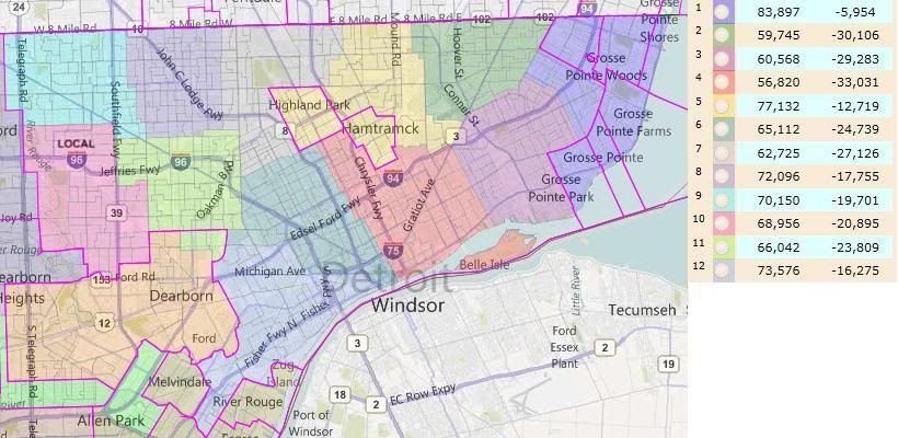
Here’s an approximation of the current districts based solely or partially in Detroit in Dave’s App:

Notice how under-populated the Detroit-based districts are. HD-01 (Grosse Pointes) is majority white; HD-12 (Southern Detroit) is majority Hispanic (total population, just short on VAP); the rest are majority African American. HD-01 is the only competive district, going 54-46 Democratic in 2010. The rest are safely Democratic.
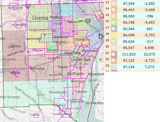
Here’s the approximation of the rest of the county’s districts:

I lightened the colors to make the locality boundaries stand out. This obscures, to my vision, one of the district boundaries. The boundary between HD-14 (Northern Downriver) and HD-22 (Romulus/Taylor) is the Taylor/Allen Park city line.
Surprisingly, to me, there are actually four districts that are overpopulated; three of which are outside the allowable deviation. HD-21 is going to have to be broken up — that’s a really significant positive deviation.
Republicans hold three of these seats: HD-19 (Livonia), HD-20 (Plymouth/Northville), and HD-23 (Southern townships). Of the remaining seats, only HD-21 is competitive. The Democrats held on in 2010 by 51%-49% – about 900 votes. All of these seats should be winnable by the right Democrat in the right environment — I’m pretty sure, for example, that Obama carried every Wayne County district. Also, I’m reasonably certain that HD-20 would have the most Republican PVI, and it was a 2010 pickup for them.
Collectively, the Wayne County districts are 246k underpopulated. The twelve Detroit-based districts account for all but .8k of that shortfall. (That is, the number of non-Detroit-based districts is the same. All of the districts lost in Wayne County will be Detroit-based.)
New Districts
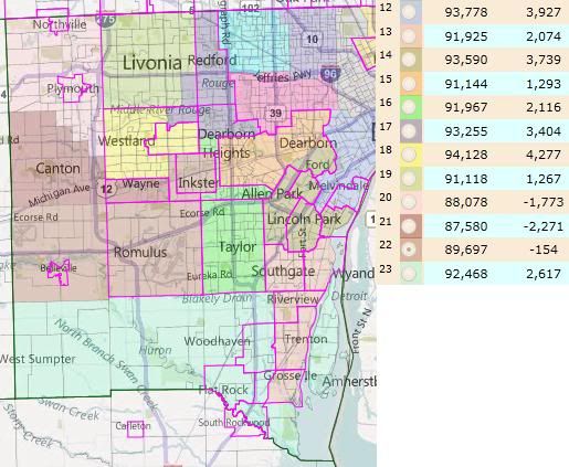
Michigan redistricting standards encourage linedrawers to maintain the integrity of localities where possible. This is the arrangement that I came to while redistributing the eleven non-Detroit-based districts within the limits of that guideline, while trying to protect the three Republican incumbents.

HD-23 (Southern townships) and HD-13 (Southern Downriver) are the only truly clean districts, with Gibraltar having been swapped from the former to the latter.
HD-21 needs to be broken up. Plymouth, Plymouth Twp, Northville, Northville Twp, Canton and Wayne combine to within 4k of the ideal for two districts. A real Republican plan would take into account how best to split Canton to their advantage; my selection of precincts to end up in HD-20 and HD-21 was arbitrary. HD-21, however, should end up more Republican than before: Van Buren Twp and Belleville together are both more Democratic and larger than Wayne.
Livonia and Dearborn are each slightly too large to be single district. I maintained Livonia’s current donation to HD-17, Dearborn ends up donating into HD-14 (Northern Downriver) instead of into Detroit. This is because HD-14 was too large with River Rouge (which therefore ends up in a Detroit-based district) but worked with the donation from Dearborn.
With Van Buren/Belleville bounded on the north by HD-21 and on the south by HD-23, the only place for them to go was into HD-22 to the east. This required Romulus and Taylor to split. I ended up combining Romulus/Van Buren/Belleville with Inkster and enough of Westland to connect them (the portion south of Garden City and east of Merriman Rd), thereby creating an African-American opportunity district. (It’s W 46.8, B 44.9 by total pop; W 50.7, B 42.4 by VAP.) Taylor then combines with the portion of Dearborn Heights south of Ford Road to make HD-16.
The final two districts are then HD-18 (Garden City and the portion of Westland west of Merriman Rd) and HD-17 (Redford, the part of Livonia not in HD-19, the part of Dearborn Heights not in HD-16, and the part of Westland not in HD-18 or HD-22).

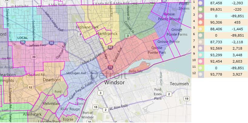
The Detroit-based district here are more representative than predictive. I don’t know enough about the incumbent representatives to know which the Republicans might favor or disfavor through redistricting. But you can see in general terms what Detroit looks like with three fewer districts than before.
HD-01 is still majority white, although slightly less so. (It should therefore become less competive for the Republicans.) HD-12 is no longer majority Hispanic. It previously contained every heavily-Hispanic precinct it could; its necessary growth diluted the Hispanic percentage down to 44.5% by total population and 39.2% plurality by VAP.
Conclusion
Republicans could potentially net as many as four state House seats in Wayne County from their control of the redistricting process: the three that are disappeared from Detroit (depending on where they end up) and HD-21, a competitive seat that will be somewhat less Democratic than before.
for you and yes thanks for doing it. I naturally look to see if “Grosse” district was there.
Is that seat GOP still. It was at one time but I don’t know now.
Naturally you carefully avoid splitting towns unless you have to. Great job.
In 2000, Wayne County was 51.7% white and 42.2% black. It’s now 49.6% white and 40.3% black, so the ratio isn’t radically dissimilar.
In 2000, 11 districts were white majority, 11 black majority and 1 Hispanic plurality but held by a white Democrat. Your map would produce 7 black majority districts, plus one district likely to produce a black representative (Inkster and Romulus) and one (south Detroit and River Rouge)where there’s a chance of a black representative due to low Hispanic turnout.
That’s between seven and nine out of twenty. Based on population, they’d be entitled to eight, but there’s an argument that there’s retrogression here, as they’re taking the hit even though the drop in population has been more or less equal amongst blacks and whites.
That said, maintaining black-majority districts would require crossing more lines, but I would certainly expect legislators whose districts were facing elimination to make this case.
Still figuring out the best way to present it. I might just revamp this diary and go statewide with it. I also drew it largely without regards to incumbents*, so I need to look that over too.
When districts get jostled around, I find it tricky to figure out which districts are the “new” ones. But insofar as I can identify them, I redrew the three districts that Detroit lost in northern Oakland/northern Macomb/southern St Clair, western Jackson/eastern Calhoun/southern Eaton, and northern Kent/northern Montcalm.
—
*Actually, on that note, to what extent to do you incumbents matter? Obviously, you can’t irk a majority of them and have the map pass. But at the same time, everyone in office in the state house now will be term-limited out before the map is redrawn post-2020 census. To what extent can party/caucus leaders get a map that’s good for the party long-term passed when it requires short-term pain on behalf of specific members?