Presidential 2012 Baseline Ratings

So anyway, I’ve been on a bit of a political hiatus since the midterm elections, and I figured that this would be a good way for me to get back in the game, to map out what I think the baseline race ratings for the 2012 presidential election are.  

It’s extremely early in the game for this, to say the least, but I wanted to start here as opposed to the house or other races that will be impacted by redistricting.  

First off, let’s put up the 2008 election results:

Photobucket

Darkest blue – 15%+ Obama win

Dark blue – 10-15% Obama win

Royal blue – 5-10% Obama win

Light blue – 0-5% Obama win

Light pink – 0-5% McCain win

Dark pink – 5-10% McCain win

Bright red – 10-15% McCain win

Dark red – 15% McCain win

You’ve probably seen this map before.  It shows, in 5% amounts, the strength of the victory by Barack Obama or John McCain.  It’s easy to see here that Obama romped in much of the northeast, the midwest, and the pacific coast while McCain won big in the plains and much of the southeast.  Most of the major battlegrounds were in the southern midwest, the south atlantic coast, and in the southwest.  Since the 2008 election is a good predictor of Obama’s strength in most states, I use these results as a major factor in my 2012 base ratings.  

Now let’s take a look at another analysis, where I basically determine which of the US states are “red”, “purple”, and “blue”.  I define a red state as a state that has either voted Republican for president in each of the last 5 elections, or a state that went for McCain by 10% or more in 2008.  I define a blue state as any state that went Democratic in each of the last 5 elections.  

Photobucket

At this point the analysis is pretty simple, and based on two simple factors, one subjective and one objective.  Now is where we start to subdivide the states based on internal factors outside of presidential politics.  I will speak briefly about every state that is NOT in the Solid D or Solid R column.

New Hampshire – This state went 54/45 for Obama, and went for Kerry in 2004, but has really taken a hard swing to the right now that foreign policy has taken a back seat to fiscal, it was opposition to Iraq that caused the D wave of 2006 here.  Ayotte’s big win over Hodes in the 2010 Senate race gives me pause.  I’m calling it a tossup.

New Jersey – This state is only on the board due to the success of Republican Gov. Chris Christie, who seems fairly popular in the state.  I think the democratic machine has caused some unnecessary problems here, but unless Obama really gets rocked, he’ll still win.  Likely D.

Pennsylvania – This is one state that I really, really think is wrongly classified as a swing state.  It’s gone blue 5 straight presidential elections.  In 2010, during the democrats’ worst election cycle in 26 years, Pat Toomey was still up after midnight before his race against Joe Sestak was called.  I’m putting this one as Lean D, and that’s being generous to the republicans.

Virginia – This is becoming a premier swing state.  Bob McDonnell crushed here in 2009, and the republicans did very well in the 2010 house races, but remember that every seat that they reclaimed in 2010 had a PVI of R+5 or higher.  The one seat that had a democratic PVI, they lost.  Obama seems popular here, especially in NoVA, but I have a feeling it will go as the nation goes in 2012.  Tossup.  

North Carolina – Barack Obama came up with a stunning 50/49 win here in 2008 as the Democrats swept the Senate and Governor races as well as 8 house seats.  They only lost 1 house seat in the 2010 deluge, but governor Purdue is unpopular.  The state’s growth seems to be in the democratic research triangle, which is heartening, but electing an african-american in the south is always tough.  I’ll give the republicans the benefit of the doubt and say Lean R, but it’s one to watch for sure.  

South Carolina – McCain won here by a 54/45 count, but I think some of the other democratic trending we’ve seen in the southeastern coastal states is bound to show up here sooner or later.  The new congressional district here is bound to be a VRA seat, and the state GOP is disgraced by people like Mark Sanford and Joe Wilson.  The 2010 governor’s race between Haley and Sheheen was closer than expected too.  Likely R, and a potential sleeper.

Georgia – One of Barack Obama’s strongest improvements from Kerry in 2004 came here, losing 47/52.  The growth here is in metro Atlanta, the most democratic part of the state, though the 2010 governor election between Deal and Barnes was disappointing.  Georgia’s house democrats did all right for the most part in 2010.  If Obama wins by as big a margin or bigger in 2012 he might have a shot here, but for now I say Lean R.

Florida – Florida is one state that really concerns me.  Obama only won here by 3%, 4% behind his national win, and the republicans absolutely killed it in 2010, winning 4 house seats and winning massively in the Senate race.  They even saw virtual criminal Rick Scott beat Alex Sink for the governorship.  I feel like this state is trending R, but I’m leaving it at tossup for the time being due to Obama’s appeal in the southeast corridor.

Ohio – Ohio is a state that gave Obama trouble in 2008, winning 52/47, just behind his national win.  Ohio dems got killed in 2010, losing 5 house seats, and Strickland lost the governorship to Kasich, albeit in a close fight.  2010 was essentially 2006 in reverse here, which leads me to believe that it will stay close to the nation as a whole once again.  Obama’s hugely popular in the major cities here, which helps.  Tossup.

Indiana – The Hoosier state appears to have reverted to its republican lean, with a blowout Senate race win in 2010 and a pickup of 2 house seats for the R’s.  But the one house seat in a swing PVI district, they lost, which is a concern for them.  I think that Obama is committed to fighting it out here like he did in 2010 and he’s got major popularity throughout the midwest, but I say Lean R going in.  

Michigan – Michigan is weird.  It’s gone D the last 5 presidential races, and Obama crushed here in 2008.  Yet 2010 was nasty for Dems, they lost 2 house seats and got destroyed in the governor’s race.  I don’t have much more than a hunch on this, but I think that the republican wave in 2010 was a one cycle aberration, and the states democratic lean will come back big in 2012.  Lean D.

Wisconsin – Now here’s a state that’s hot, hot, hot politically right now.  Obama’s popularity in the upper midwest combined with the vicious overreach that governor Walker and the state GOP is pulling right now could have a reverberating effect in the state and region.  I just feel really good about all these upper midwest states, don’t know why, but I do.  Lean D.

Minnesota – The Republicans held their convention here in 2008, but still couldn’t come within 10% of winning.  Now they did make big gains to win both houses of the legislature but still lost the governor’s race, an obvious red flag in a year as good as 2010.  Minnesota hasn’t gone red in seemingly forever, and I don’t expect this to be the year either.  Lean D.

Iowa – This heartland state always has a big impact on presidential politics, and it figures to be a swing state again in 2012.  It always stays close to the national average, probably about as democratic as Ohio is republican.  Iowa dems actually did pretty well in the legislature in 2010 despite losing big in the senate and governor’s races, and they kept their 3 house seats.  It’s a tossup, barely, I feel good about it.

Missouri – Obama just barely lost here in 2008, and the state is trending republican, despite their democratic governor being very popular.  The 2010 senate race was a blowout, and it appears that the rural areas are getting to be off limits to Dems.  I’m going to put this one at Lean R at the outset.

Colorado – This state has quickly moved into the tossup range of presidential politics, and the democrats had some encouraging signs here in 2010, most notably holding the governor and senate seats that year, despite losing 2 house seats.  I’m not willing to put this one into the leaning D column yet, but demographic shifts are helping the dems here too.  Tossup.

North/South Dakota – The Dakotas are both very small states, and states that McCain didn’t really perform all that well in.  Now it appears that they are turning in the rightward direction a bit, but it’s hard to base anything on the 2010 senate contests as one race wasn’t contested and the other saw probably the most popular pol in the US to his state, John Hoeven, romp to a big win.  I think that these could be in play if Obama wins big.  Likely R.

New Mexico – This is a state that is really turning in the blue direction.  The 2010 wave didn’t hit especially hard here, despite losing the governorship and one house seat.  It’s hard to imagine the republicans getting a win here in an even presidential cycle given the state’s general movement toward the democrats, and Obama won 57/42 in 2008.  Likely D.

Montana – The high plains were a big stomping ground for Bush in 2000/2004, but Obama really pressed McCain here in 2008, losing by just 2%.  I think that it’s very possible that Obama could play here, especially with a competitive senate race on tap as well.  I don’t know much about the state honestly, so I’ll say Lean R.

Arizona – This is probably the single toughest state to call in 2012 because the state appears to have moved to the republican side due to SB1070 and a few other factors, but the presidential race could have been close in 2008 had it not been for the McCain home state effect.  With an intriguing senate race on the board too, this will be interesting.  I start this out at Likely R.

Nevada – This, like New Mexico, is another state that appears to be moving toward being solidly democratic, as evidenced by Harry Reid’s 2010 win in a bad year.  Obama won big here in 2012, and the pollsters seem to rate this state as being more republican than it really is.  I’m starting Nevada out at Lean D.

Baseline: The current Obama approval / disapproval in the pollster.com regression is 48.4 to 46.3 in favor.  Assuming that every voter who approves of Obama votes for him and everybody that disapproves doesn’t, that gives him about a 2% polling advantage, which I extrapolate to about a 2% national victory for Obama over whomever the Republicans nominate if the election were to be held today.  (Obviously, the person the Republican Party nominates could have a big impact on polling numbers, but I’m not going to consider that aspect of it yet)  These following ratings assume a 2% democratic win based on the current pollster regression.  

Photobucket

Solid D – Dark Blue

Likely D – Medium Blue

Lean D – Light Blue

Toss Up – Green

Lean R – Pink

Likely R – Bright Red

Solid R – Dark Red

4 New Hispanic VRA Districts in TX

Hispanic Population Growth in Texas over the past 20 years

In 1990, according to the U.S. Census, there were 4,339,905 Hispanics in Texas. At this time, Hispanics were 25.5% of Texas’ total 16,986,510 population. 7 of Texas’ 30 Congressional Districts (23.3%) were Hispanic Voting Rights districts.

By 2000, Texas’ Hispanic population had increased by 2,329,761 people (enough people to fill about three and a half congressional districts) to 6,669,666, growing at an incredible rate of 53.7%. Hispanics were responsible for 60.3% of Texas’ total population growth in the 1990s. Hispanics were now 32.0% of Texas’ total population. This population growth earned Texas two new Congressional Districts following the 2000 Census. However, neither of the two new districts were drawn as a Hispanic Voting Rights district. Ironically, despite the fact that Hispanic population growth had driven Texas’ population gains, the percentage of Texas Congressional Districts which were dominated by Hispanics actually decreased slightly, to only 21.9% of districts (7 of 32).

By 2010, Texas’ population has ballooned to 25,145,561, according to Census estimates. Hispanic population growth continued to drive Texas’ overall population growth, increasing by approximately another 2,791,255 million people (enough people to fill another four congressional districts). According to the 2010 census, 37.6% of Texas’ 25,145,581 people are Hispanic.

Over the 20 year period from 1990 to 2010, Texas’ Hispanic population more than doubled from 4,339,905 to, roughly, 9,460,921 million people. Texas’ Hispanic population has added 5,121,016 people to Texas’ total population. This is enough people to fill 7.3 entire Congressional Districts. Alternatively stated, the increase in Texas’ Hispanic population from 1990 to 2010 is larger than the entire population of the state of Colorado, and almost as large as the entire population of the state of Minnesota. During this 20 year period, Hispanics were responsible for about 62.8% of Texas’ total population increase. Over the whole 20 year period, Texas’ Hispanic population increased by about 118%. By contrast, Texas’ non-Hispanic population increased by only 24%.

2011 Congressional Redistricting

But statistics about anticipated Hispanic political influence in Texas’ are much less striking than statistics about Texas’ recent Hispanic population growth. Texas will gain 4 new Congressional Districts following redistricting this year, in addition to the 2 new districts gained 10 years ago. There seems to be near universal agreement that one of the new seats will be a Hispanic dominated district in Dallas-Fort Worth, drawn to rescue overextended Republican incumbents Kenny Marchent (TX-24) and Pete Sessions (TX-32).

But beyond that one seat, it is not at all certain that the legislature will draw any other additional districts in which Hispanics can expect to have any real political influence. If only one additional Hispanic majority district is drawn in Dallas-Fort Worth, only 7 of 36 Texas Congressional Districts will be Hispanic Voting Rights districts. As a percentage of the total, this is 19.4% of Texas’ U.S. House seats. This is, of course, a lower percentage than in 1990, when 20% of Texas Congressional Districts (6 of 30) were Hispanic Voting Rights districts – despite the tremendous growth of Texas’ Hispanic population within the past 20 years.

There’s some talk of creating an additional Hispanic dominated district in South Texas as well, perhaps based around the very strong population growth in Hidalgo County. But this is not certain, and may well be accompanied by creative shenanigans designed to limit Hispanic influence in TX-23 and TX-27 as much as is humanly possible, in order to protect Republican incumbents Quico Canseco and Blake Farenthold.

Beyond that, a small number of redistricting prognosticators have suggested that a third additional Hispanic dominated (or at least Hispanic influence) district might be created. Maybe it would be somewhere in Houston. Maybe a district would be drawn, once again, in an attempt to replace Lloyd Doggett with a Hispanic Representative. But the details are not really very clear. And there has been some doubt as to whether it’s even really possible to draw three (much less 4) new genuine Hispanic Voting Rights districts, given the fact that Hispanic population growth has been spread over large parts of the state.

Gingles’ 3 Prongs and Section 2 of the Voting Rights Act

This doubt is misplaced. It is very much possible not only to create 3 new Hispanic Voting Rights districts, but to create 4 new Hispanic Voting Rights districts. What’s more, these are not contorted racial gerrymanders, but rather reasonably compact districts. Nor are they districts with nominal 50% Hispanic majorities, where Hispanics are not a majority of the Voting Age population. With the possible exception of the second Dallas-Fort Worth Hispanic Voting Rights Act district, we’re talking about compact districts with Hispanic population shares well into the 60s, 70s, and even 80s (in the case of a few South Texas districts).

* More or less everyone seems to concede that the time has come for 1 Hispanic Voting Rights district in the Dallas-Fort Worth Metroplex. Well, it turns out that the Dallas-Fort Worth area is actually on the verge of having not just 1 Hispanic Voting Rights district, but 2 Hispanic Voting Rights District.

* In addition, an additional compact Hispanic Voting Rights Act district (about 2/3 Hispanic) can be created in Houston, while preserving the existing TX-29.

* Finally, Hispanic population growth has been strong enough in South Texas to draw an additional Hispanic Voting Rights district, even while keeping all South Texas districts with overwhelming Hispanic majorities (more than 70% or even 80% Hispanic). Frankly, the interesting question along the Rio Grande is not whether one more Hispanic Voting Rights district can be added, but rather whether it might be possible to add another 2 Hispanic Voting Rights districts.

And if it is possible to draw additional compact Hispanic Voting Rights districts, there is a strong case that Texas is legally obligated to do so by Section 2 of the Voting Rights Act. In the case of Thornberg v. Gingles, the Supreme Court layed out a three basic threshold requirements for finding a minority vote dilution violation of Section 2 of the Voting Rights Act in redistricting cases. They are:

1) The minority group “is sufficiently large and geographically compact to constitute a majority in a single-member district.”

2) The minority group is “politically cohesive.”

3) “That the white majority votes sufficiently as a bloc to enable it … usually to defeat the minority’s preferred candidate.”

All three of these requirements apply in the case of Texas:

1) As I will show below, Hispanics in Texas do form a sufficiently large and compact population in Texas to constitute a majority in a single member district. Indeed, they form a sufficiently large and compact population to form not just bare majorities, but very large majorities in multiple new districts.

2) Texas Hispanics are politically cohesive. They tend to vote as a bloc for candidates (usually Democrats), and tend to vote especially strongly for Hispanic candidates. This is abundantly clear from sources such as exit polls and past election results.

3) In Texas, white voters vote overwhelmingly Republican as a bloc, in opposition to Hispanics. Voting in Texas occurs to large degrees along racial lines. For the most part, the only place where this may not be the case quite as much is Austin.

To be sure, redistricting and the Voting Rights Act are unpredictable areas of Supreme Court jurisprudence, and almost anything could happen in the coming flurry of lawsuits that will be filed across the nation as redistricting begins. But if the Texas legislature, as anticipated, limits the number of new Hispanic Voting Rights districts drawn, and if Hispanics in Texas file Section 2 vote dilution lawsuits, they will have strong claims and a good chance at success.

Now, to the districts!

Overall Map

First of all, this map is drawn with 2010 census data (data available for download here) using 2010 precincts (shapefiles available for download here). Because this map is drawn on the precinct level, it misses the level of detail you could get by drawing on the block group or block level. Also, I drew it quickly and without dedicated redistricting software (just plain old GIS software), and that means that I probably did a pretty sloppy job. For those reasons, it is almost certainly possible to improve on this map, making the districts more compact and/or increasing the Hispanic percentages in the new Hispanic Voting Rights districts. My purpose was not to draw the best possible map adding 4 new Hispanic Voting Rights districts, but rather to simply show that it is very much possible to draw 4 new Hispanic Voting Rights districts.

I also did not bother to draw the non-Voting Rights Act districts. Those are not the interesting part of Texas redistricting; it goes without saying that the State Legislature will draw all of them as safe Republican districts to protect their incumbents. So I ignored those districts.

Here’s the overall statewide map, with county/precinct lines taken out so you can see the shape of the districts:

And here’s the same map, with county/precinct lines visible:

And here’s a table showing the demographic makeup of all the districts, including total population and VAP data by Race and Hispanic origin. Note that for African Americans and Asian Americans, I used the census data for Non-Hispanic Single Race African Americans and Asian Americans. So if you were to include multiple race African Americans and Asian Americans, the actual numbers would be a bit higher for those two groups.

South Texas

There are four districts based in South Texas. In addition, I am lumping in TX-16, which is in El Paso, as part of “South Texas.”

TX-27: 21.3% Anglo, 74.6% Hispanic, 2.1% African American, 1.2% Asian (Hispanic VAP – 70.7%)

TX-15: 20.3% Anglo, 76.9% Hispanic, 1.7% African American, .6% Asian American (Hispanic VAP – 72.4%)

TX-35: 15.0% Anglo, 82.9% Hispanic, .6% African American, 1.0% Asian American (Hispanic VAP – 79.9%)

TX-28: 18.4% Anglo, 79.2% Hispanic, 1.1% African American, .5% Asian American (Hispanic VAP – 75.5%)

TX-16: 14.6% Anglo, 80.2% Hispanic, 2.9% African American, 1.1% Asian American, (Hispanic VAP – 77.7%)

In South Texas, TX-27 is preserved largely as is, but has to drop its part of San Patricio County because of population growth. This is bad news for Blake Farenthold, because the district becomes more heavily Hispanic. TX-15 remains similar to its previous incarnation, but now picks up some additional counties to the north, including Victoria. TX-35 is added as a new seat based in Hidalgo County. Like TX-15, it heads way to the north, almost but not quite to San Antonio. TX-35 ended up as an 82.9% Hispanic district – there were simply more Hispanics in South Texas than I could figure out what to do with, even after adding a new Congressional district. TX-28 shifts to the west. It’s still based in Laredo, but stretches all the way to El Paso, taking a lot of territory that was formerly in TX-23. In addition, San Angelo in Tom Green County is added to the district. It pulls entirely out of Hidalgo County and out of the San Antonio area. And speaking of El Paso, TX-16 remains pretty much exactly the same.

Clearly, there’s no difficulty at all with fitting 5 full districts along the US-Mexico border. There’s no need for any of these districts to enter San Antonio, Austin, or Houston: all 5 districts easily have 70% or more Hispanic population, while staying outside of major non-border metro areas. There are also many other counties with large minority (and even majority) Hispanic populations nearby, leading me to wonder what the map might look like would happen if one tried to add not just one, but two new South Texas Hispanic Voting Rights Districts.

You can make an argument that many of these districts are not really compact. For example, the new 35th district starts in McAllen and, reaches up to the San Antonio’s exurbs nearly 300 miles away. And in truth, you could draw more compact districts by simply drawing a district entirely within Hidalgo County. But currently and in the past, districts in South Texas have been drawn with appendages reaching to the north, into counties with significant but not monolithic Hispanic populations. South Texas districts are drawn this way for a reason. All the counties directly along the Rio Grande are overwhelmingly Hispanic. Hidalgo County, for example, is now 90.6% Hispanic, and has enough population for 1.1 Congressional Districts. If districts were drawn solely within counties along the border, those districts would be almost entirely made up of Hispanics, thus packing Hispanics into a small number of overwhelmingly Hispanic districts. At the same time, counties a bit further north such as Victoria County, which are a bit less than outright Hispanic majority, would end up in districts which might have significant Hispanic populations, but not high enough Hispanic populations to form genuine Hispanic Voting Rights districts. This issue was considered in redistricting in the 1980s, and it was determined that packing Hispanics into one or two 90% Hispanic districts along the border would be a violation of Hispanic voting rights, and would violate the Voting Rights Act. Neither the facts nor the conclusion has changed since then.

San Antonio (and Austin)

In the South Texas section above, I distinguished San Antonio (Bexar County) from South Texas. I did this for a reason: it is now possible to draw two compact 2/3 Hispanic Congressional Districts entirely within Bexar County. Hispanic population growth in San Antonio has been strong, and TX-23 can contract entirely within the county.

In addition, it’s now possible to draw a majority Hispanic district in the Austin area (without reaching into South Texas, San Antonio).

TX-20: 22.9% Anglo, 65.6% Hispanic, 8.3% African American, 1.6% Asian American (Hispanic VAP – 62.1%)

TX-23: 24.3% Anglo, 65.6% Hispanic, 5.9% African American, 2.4% Asian American (Hispanic VAP – 61.6%)

TX-25: 31.9% Anglo, 53.4% Hispanic, 10.6% African American, 2.3% Asian American (Hispanic VAP – 47.9%)

I simply divided TX-20 and TX-23 so that both districts would have the same Hispanic population %. Of course, the State Legislature would probably try to draw the lines between the two districts differently, to make TX-23 as Republican as possible and to give Quico Canseco the best chance of winning.

TX-25 is a purely Central Texas Hispanic Majority District. But while TX-25 has an overall 53.4% Hispanic majority, Hispanics are only 47.9% of the VAP in this district, so I am not counting it as one of the 4 new Hispanic Voting Rights Districts. It might be possible to exceed 50% of the VAP by drawing on the block level, but it looks like the 50% hurdle may be just slightly out of reach. The legislature is probably unlikely to draw a district like this – either they will attempt to outright eliminate Lloyd Doggett (perhaps at their own peril) or they will simply give him the most Democratic district possible in the Austin Area. And this is not the most Democratic district possible in the Austin area, but rather (roughly) the most heavily Hispanic district possible in the Austin area.

Houston

It VERY easy to draw a second compact Hispanic Voting Rights district in Houston – it seems like the only way Houston will not get a second Hispanic Congressional District is if the Supreme Court overturns Gingles. Hispanic population growth in Southwest Harris County has been strong enough that it is no longer necessary for TX-29 to extend an arm into the north side of Houston. This means that the north side can be combined with increasingly heavily Hispanic portions of western Houston to form a new Hispanic Voting Rights district. In addition to drawing two Hispanic districts, I drew TX-9 and TX-18, which are currently dominated by African American voters, in order to demonstrate that African American voting rights are not harmed by the creation of a new Hispanic district.

TX-9: 12.2% Anglo, 38.2% Hispanic, 36.3% African American, 12.9% Asian American (African American VAP – 35.9%; Hispanic VAP – 35.2%)

TX-18: 28.7% Anglo, 26.0% Hispanic, 38.8% African American, 4.7% Asian American

TX-29: 18.4% Anglo, 67.7% Hispanic, 10.3% African American, 2.6% Asian American (Hispanic VAP – 63.3%)

TX-36: 15.6% Anglo, 64.2% Hispanic, 14.7% African American, 4.4% Asian American (Hispanic VAP – 60.0%)

Admittedly, the western part of the new TX-36 has somewhat non-compact lines. However, this is because the precincts in this area are very large and there has been a lot of population growth in this area. There was an excess of 35-45% Hispanic precincts that could have been added to this district – my problem was deciding which ones to include. Ultimately I picked 45% Hispanic precincts over 40% Hispanic precincts, which made the western part of the district choppy looking. This is one area where using block group and block level data could make a big difference in drawing a more compact looking district with a higher Hispanic population. There is also a delicate balancing act in deciding which precincts should go in TX-18, vs. which should go in TX-29 and TX-36, because a lot of precincts have high Hispanic and high African American populations. I did not do an optimal job of this, and I am very sure that a more careful drawing could make these districts better looking and/or could increase the Hispanic percentages in TX-29 and TX-36. But even with my sloppy drawing, I was easily able to draw a district which is nearly 65% Hispanic. There are also some heavily Hispanic parts of South-west Houston around the intersection of the Southwest Freeway and the Westpark Tollway which I left out of the new TX-36. By including those areas in the district, the Hispanic population could probably be increased while also making the new TX-36 more compact looking. However, it would require cutting through the Galleria area (and possibly separating

TX-29 speaks for itself – impressive Hispanic population growth makes a much more compact South-West Harris County district possible.

TX-18 remains basically similar to its current form. However, to reach the northern part of the district (the area around George Bush Continental Airport), it cuts through the north-east rather than through the north-west, in order to make room for TX-36. I also added some white Democratic areas (Montrose), which makes John Culberson in TX-7 safer. My precinct selection was pretty sloppy though, and I included some white Republican areas as well. In any case, a strong

TX-9 actually ended up with a slight Hispanic plurality (but with an African American VAP plurality). I was not very careful at all about precinct selection here, and I am pretty sure I left some heavily Democratic precincts out, which would go in either TX-7 or TX-22. In drawing this district, I imagine that the legislature will be interested in doing whatever it possibly can do to shore up TX-7 and TX-22.

Dallas Fort-Worth

It’s pretty much a given that Dallas-Fort Worth will get its first Hispanic Voting Rights district. What is not appreciated is that the Metroplex is actually on the verge of being able to have not just one, but two Hispanic Voting Rights districts. These two new Hispanic Voting Rights districts can be drawn without decreasing the African American population in TX-30. Actually, even in my sloppy drawing, the African American population percentage goes up 5% to 44.3%, as a result of removing heavily Hispanic areas which are currently packed into the district.

TX-30: 27.1% Anglo, 22.5% Hispanic, 44.3% African American, 4.1% Asian American

TX-33: 22.4% Anglo, 58.8% Hispanic, 14.6% African American, 2.8% Asian American (Hispanic VAP – 52.8%)

TX-34: 20% Anglo, 60.7% Hispanic, 15.4% African American, 2.5% Asian American (Hispanic VAP – 54.9%)

TX-34 is the most non-compact looking of all the districts I drew. It could benefit greatly from a more careful drawing, and from using block group and block level data rather than precinct level data. I probably did not arrange Metroplex Hispanic TX-33 and TX-34 in the most efficient way between the two districts, and I ended up including a number of North-Arlington precincts with very low Hispanic populations, in order to increase the compactness of the district a little bit. These could be taken out and the Fort Worth area could be cleaned up. This map is not optimally drawn, either in terms of compactness or Hispanic population %.  Ultimately, the question of whether or not Dallas-Fort Worth gets two Hispanic Voting Rights districts may come down to what exactly a court considers to be a “compact” enough district for the purposes of Gingles’ second prong. It’s a pretty good bet that groups like MALDEF and LULAC will try to draw a map in which both TX-33 and TX-34 are as compact as possible and have as high Hispanic populations as possible, and that they will present their maps to a court in a Section 5 lawsuit.

There is less to say about TX-33. It is more compact looking than TX-33 (except maybe for the thin connection through downtown Dallas), but has a slightly lower Hispanic population percentage. There may be some question about whether the Hispanic population is really large enough in this district. There are some heavily Hispanic areas in north Dallas which I left out of the district. It might be possible to increase the Hispanic percentage by linking the eastern and western parts of this district through the LBJ Freeway (I-635) rather than through downtown, but I did not do this because it would have disrupted TX-32 (possibly even throwing Pete Sessions into TX-30!!!). Obviously, that is something that the legislature will avoid when they are drawing the map.

Conclusion

So there we have it, Texas with 4 new Hispanic Voting Rights districts (plus with a quasi-Hispanic Voting Rights district in the Austin area).

These are obviously not districts that the Republican controlled legislature will want to draw, but these are districts that clearly can be drawn, given the magnitude and concentration of Texas’ Hispanic population growth. We can expect a large legal brawl over these four districts.

But at the end of the day, even if all 4 new districts are drawn as new Hispanic Voting Rights districts, only 11 of Texas’ 36 congressional districts (30.6%) will be Hispanic Voting Rights districts. Hispanics will still be under-represented when compared to their share of the Texas population (37.6%) and compared to their share of the Texas Voting Age Population (33.6%).

And again, my map is simply a crude initial drawing, outlining some of the things that are possible in Texas. With time, software, block group/block level data, and care, it is undoubtedly possible to draw more compact looking districts with higher Hispanic population percentages than I achieved. It may even be possible to add more Hispanic Voting Rights districts than 4. It will be interesting to see what people come up with.  

California with 37 VRA seats

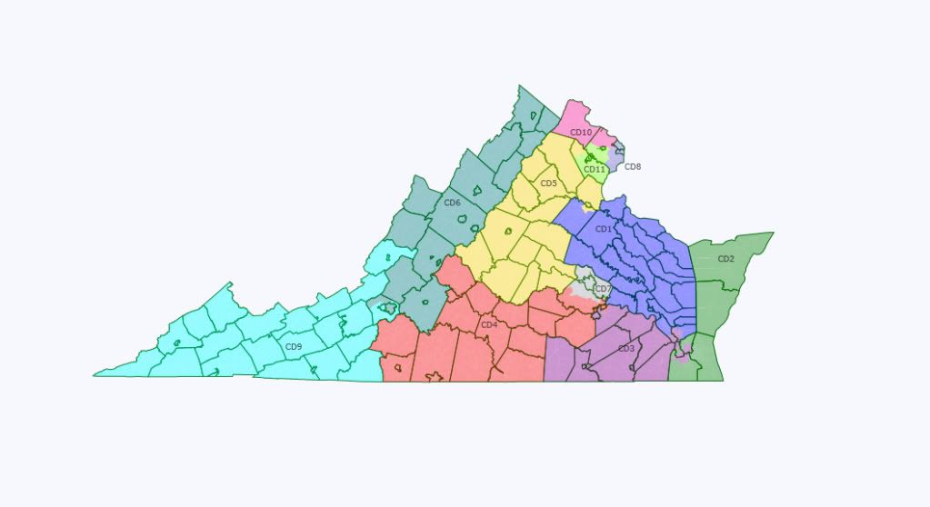
Here we go again! Another California map…

I dunno how much demand is actually left for California redistricting maps, but here’s my latest version anyhow. Since this’ll be the last map I post (of California or any other state) until actual Census data is available, I’ve decided to go all out.

When I posted my original California map that basically disregarded the VRA, and again when I posted my VRA maps of Southern states, I was strongly encouraged to create a new California map that takes the VRA as its starting point. While initially somewhat resistant, I was persuaded that I should do exactly that mainly when I looked over the new California redistricting guidelines and saw that they prioritize the VRA above all other criteria.

Moreover, whereas my initial map used the 2008 population estimates, I wanted to make a map using the more accurate American Community Survey projections. So, I’ve created the following maps and analysis by this methodology:

1) I first addressed Section 5 preclearance concerns to ensure that none of the four covered counties (Kings, Merced, Monterrey, Yuba) would be subject to a “retrogression” challenge.

2) I then addressed Section 2 requirements that majority-minority districts be drawn wherever compact minority communities permit the drawing of such districts without substantially ignoring traditional redistricting criteria.

3) I then filled in the rest of the map based on the non-partisan criteria specified by the California guidelines (contiguity, geographic integrity, communities of interest, compactness). As such, I altogether disregarded partisan data and incumbent residency as required by law (especially easy to do on the ACS version at Dave’s app which doesn’t feature partisan data).

4) However, I wanted to know what the partisan effects would be, so I then had to translate my ACS-VRA map into partisan figures – which was easily the most time-consuming part of this exercise.

5) Finally, I was curious to see how the maps I drew would match up with the current incumbents, so I pinpointed where each one lives and identified in which district on my map they would end up.

The resulting maps below feature 37 majority-minority seats of which 15 are majority-Latino and 1 is majority-Asian.

So, I’m finally ready to present all that after the jump. Needless to mention, analyzing California is a daunting task, so I’ve decided to organize my presentation as follows:

For the purposes of my discussion, I’ve divided the state into the following regions: (1) Northern California (including Sacramento); (2) the Bay Area; (3) the Central Valley & Central Coast; (4) Los Angeles; (5) Orange County & the Inland Empire; (6) the San Diego Area.

For each region, I’ve posted some general comments, then listed the 2008 Obama/McCain figures for each district including the incumbent of that currently numbered district, and then posted the relevant maps. I then have three sections of commentary: VRA Implications, Partisan Impact, and Incumbents.

A quick note on the latter: It goes without saying that where the incumbents end up in the new maps is highly speculative. The reason why I decided to look at this anyhow is twofold: (1) at the very least, it gives some sense of how the new maps are likely to scramble the incumbents, even if the actual final arrangement is very different; (2) the places where incumbents are likely to end up together in the same district or where districts are likely to initially end up without a resident incumbent obviously correlate with the most highly gerrymandered parts of the state, and so therefore it’s safe to say that the incumbents that are most affected on my map will be the ones at highest risk under the actual maps. Of course, residency within a district is not a requirement to run for Congress, but Congress critters do generally prefer to run where they live – or to move if they have to.

One last note before I get underway: I’ve played with the California maps enough at this point that I have a rather good sense of what decisions are likely to help Democrats or Republicans. All else being equal, I have generally made those decisions which are most helpful to the GOP. On one hand, I’ve done this to minimize unfounded accusations of partisan mapping bias on my part. On the other hand, I’ve done this because I think similar decisions will maximize the likelihood of a map being approved by the Redistricting Commission which requires three GOP votes to pass the maps. On the third hand (?!), I’ve done this because I would rather see a ‘worst-case scenario’ for Democrats, with the awareness that the actual maps are likely to be somewhat more favorable, than to promote a rose-colored glasses view inconsistent with the probable outcome. In short, if you are a Republican and you don’t like my maps, you probably need to reflect on how consistent your perception of California is with reality.

So, without further ado, here goes!

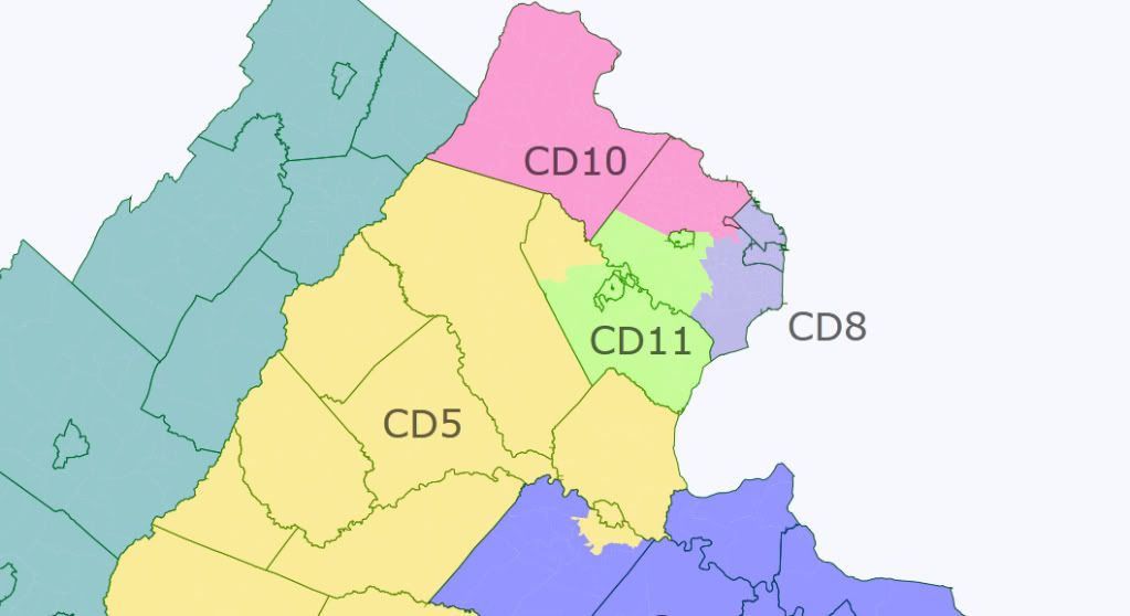
Northern California & Sacramento

Below I’ve started with two maps. The first is a broader view of NorCal while the second is a closer view of Sacramento so that it’s clear where I’ve drawn the lines and how the Sacramento districts intersect with the surrounding districts.

In my view, the NorCal mapping scheme is very likely to resemble this arrangement. (I guess that’s stating the obvious..) On one hand, there’s a certain symmetry: two districts anchored by Sacramento, two compact districts extending toward the northwest and the northeast respectively, and one district covering the sparsely populated northern end of the state.

I’ve seen several maps that further subdivide Sacramento County or that create more elongated districts stretching as far as the Oregon border. I personally don’t think the such maps are consistent with the current rules that call for minimizing county/city subdivisions and that generally prohibit bypassing centers of population to reach more distant populations.

In any case, here are the partisan figures for these five districts. I’ll post further comments after the maps.

CA-01 (D-Thompson): 61% Obama – 37% McCain

CA-02 (R-Herger): 47% Obama – 51% McCain

CA-03 (R-Lungren): 50% Obama – 48% McCain

CA-04 (R-McClintock): 44% Obama – 54% McCain

CA-05 (D-Matsui): 68% Obama – 30% McCain (61% Minority – 18% Asian; 25% Latino)


VRA Implications: There’s not much in the way of VRA implications with concern to mapping Northern California. Yuba County is a Section 5 preclearance county but it’s currently in a 76% white district. On my map, it goes from its present location in CA-02 represented by Herger to the CA-04 district represented by McClintock. The new CA-04 district has virtually identical racial/partisan stats as the current CA-02, so there’s no “retrogression” concern. The only other district of VRA interest is CA-05 and my map takes it from 56% minority to 61% minority. There’s no prospect of creating any other majority-minority districts, nor is there a prospect of creating a district with a majority from a single minority group.

Partisan Impact: Herger’s CA-02 district goes from 55% McCain to 51% McCain and Lungren’s CA-03 goes from an even 49%-49% split to 50% Obama/48% McCain. In the case of CA-02, the district should be safe enough for Herger, but he’d probably have to actually put a bit of effort into his reelection campaigns and there might be an opening for the right Democrat in a good year for Dems, particularly if the seat comes open.

Lungren’s CA-03 might be far more problematic from his standpoint. On paper, it’s a ‘tossup’ at worse, but Lungren’s been facing stiff challenges in recent elections, and he doesn’t strike me as a particularly good fit for this district that’s now fully contained in Sacramento County. While the district should be quite suitable for a Sacramento Republican, I’m not too sure that Lungren is that Republican, and the area is gradually trending leftward (which will be a problem for the GOP no matter how the ‘second’ Sacramento district gets drawn).

The other three districts are not meaningfully affected, though Thompson’s CA-01 does drop from 66% Obama to 61% Obama.

Incumbents: My map doesn’t displace any of the current incumbents in these five districts and it’s unlikely that any mapping scheme would. That includes Tom McClintock: A lot of sources still list his residence as Elk Grove in Sacramento County, but he’s officially moved to Roseville in Placer County.

The Bay Area

My latest map of the Bay Area is below.

The most consequential effect of using the ACS figures has been that CA-11 is clearly pushed out of the Bay Area and into the Central Valley (which is where I’ll deal with it below). Otherwise, my main concerns here were maximizing the number of majority-minority seats and carving out a majority-Asian seat in particular.

In my experimentation with mapping the Bay Area, it seems fairly clear to me that there are only two districts with significant ambiguity as to how the lines will end up: On my map below, they’re CA-10 and CA-16. What does seem clear enough, however, is that most of the districts will be arranged along the Bay coast, with a ‘hinterland’ district centered in Contra Costa/Alameda, and then leaving what I think of as a ‘mop-up’ district piecing together the ‘leftovers’ from the districts with more obvious placement (e.g., CA-10 on this map).

It’s also worth noting that the contours of this mapping scheme were partially determined by what has to happen in the Central Valley to maintain a VRA-compliant CA-18 district. To do that, you have to split off the heavily Latino parts of Stanislaus and San Joaquin counties, which means you have to situate a district on the remainder which still leaves a part left over on one end or the other. The most coherent mapping scheme I could identify involved attaching that leftover part to CA-10 rather than, say, CA-19. Either way, it doesn’t make much difference: CA-10 will still be heavily Dem and CA-19 will still be heavily GOP.

CA-06 (D-Woolsey): 76% Obama – 22% McCain

CA-07 (D-Miller): 73% Obama – 25% McCain (52% Minority – 15% Asian; 24% Latino)

CA-08 (D-Pelosi): 85% Obama – 13% McCain (52% Minority – 29% Asian)

CA-09 (D-Lee): 88% Obama – 10% McCain (64% Minority – 20% AA; 20% Asian; 21% Latino)

CA-10 (D-Garamendi): 61% Obama – 38% McCain (55% Minority – 24% Latino)

CA-12 (D-Speier): 74% Obama – 25% McCain(57% Minority – 32% Asian; 19% Latino)

CA-13 (D-Stark): 70% Obama – 28% McCain (74% Minority – 51% Asian)

CA-14 (D-Eshoo): 71% Obama – 27% McCain

CA-15 (D-Honda): 71% Obama – 27% McCain (71% Minority – 26% Asian; 39% Latino)

CA-16 (D-Lofgren): 65% Obama – 34% McCain (52% Minority – 17% Asian; 25% Latino)

VRA Implications: My map takes the Bay Area from seven majority-minority districts out of 11 to eight majority-minority districts out of 10. The CA-13 district is also majority-Asian. In some cases, I’ve swapped proportions (i.e., CA-08 goes from 58% to 52% minority while CA-12 goes from 52% to 57% minority; CA-16 goes from 69% to 52% minority while CA-15 goes from 53% to 71% minority). This is augmented by the fact that CA-11 goes from the current 63% white district to a 52% minority district in the Central Valley and CA-17 on the Central Coast becomes a majority-minority district.

For the record, you evidently cannot create a majority-Latino district in San Jose even if you ‘give up’ the majority-Asian district. The Latino population is too intermixed with the Asian population in much of the area.

Partisan Impact: The Bay Area seats will all be heavily Democratic seats no matter how they’re mapped out.

It’s been suggested elsewhere that ‘a foothills seat in Contra Costa / Alameda’ could be a tossup seat. This is obviously not true – mainly because you don’t have anywhere near enough people there as should be self-evident in these maps. The most Republican seat that I was able to create following that guideline was a 59% Obama seat. Once you take in all the most Republican areas in the eastern part of the Bay counties, you must necessarily go into heavily Democratic areas in order to fill out the necessary population.

There’s also been a suggestion that: “The outer areas of current CD14-CD15-CD16 could end up being a tossup seat.” That makes no sense whatsoever. The “outer areas” of those districts are basically Santa Cruz County, which was a 77% Obama county. To make the long story short, anyone who sees a “tossup” district in the Bay Area (much less a Republican district) is hallucinating.

Incumbents: My mapping scheme would inconvenience several Bay Area incumbents, with at least one of them being out of a job (unless he or she moves to the Central Valley). McNerney lives in Pleasanton (central Alameda County) which ends up in CA-16 on this map. Since this district is most similar to his current district, I think he’d be very likely to run there. Mike Honda lives in the Campbell area of San Jose, which ends up in CA-14 on this map. This is essentially Anna Eshoo’s district who lives in Atherton which is still in CA-14. Meanwhile, Zoe Lofgren lives in San Jose and would end up in CA-15.

As I see it, the most obvious place for Mike Honda to run would actually be CA-13 since it becomes majority-Asian and takes in substantial parts of his current district, but if Pete Stark doesn’t retire that’d mean a primary battle – aside from the residency issue. Ultimately, I don’t know how this would be sorted out. Perhaps some Californians could comment on it.

Whatever the case, tidying up the lines in the San Jose area makes it highly probable that at least two Democrats will end up in the same district – even leaving aside the fact that the Bay Area will lose a seat.

It’s also worth noting that Garamendi lives in Walnut Grove (Sacramento County) which just barely ends up in this CA-10 district. That said, I think Garamendi will end up running in whatever district most resembles his current district regardless, whether or not he has to move.

Central Coast & Central Valley

The Central Coast and the Central Valley are really two separate regions, but I’ve decided to cover them together for the sake of expedience. By and large, the mapping scheme that I settled on was dictated by Section 5 preclearance concerns, since three of these counties are covered: Kings, Merced, and Monterey. In short, I mapped the relevant districts first (CA-20, CA-18, and CA-17) to satisfy ‘retrogression’ concerns, and then mapped the rest accordingly.

A couple of general points are worth noting. San Benito County only has about 55,000 people and doesn’t really make a significant difference regardless how it’s mapped. I basically chose to add just enough of it to CA-17 so that the boundaries with CA-12 to the north and CA-23 to the south could be the coastal county lines. The remainder then obviously belonged with CA-20 (but again, it makes no meaningful difference to either the partisan or ethnic breakdown).

As for the Great Basin, it’s even more sparsely populated and even less consequential than San Benito. I’m sure there’s some Republican out there who imagines that if the Great Basin were instead divided and appended to the more central districts it’d somehow benefit the GOP. Any such Republicans are misguided. About 30,000 people live in the Great Basin and chopping it up does little besides create a less coherent map. But, hey, if it makes the Commission feel better for some reason, I say go for it.

Besides reiterating that CA-11 isn’t really ‘McNerney’s district’ on this map – having been displaced from the Bay Area to the Central Valley due to population shifts – I’ll save the rest of my commentary for below.

Here’s the Obama/McCain breakdown for these districts:

Central Coast

CA-17 (D-Farr): 73% Obama – 25% McCain (54% Minority – 44% Latino)

CA-23 (D-Capps): 57% Obama – 41% McCain

CA-24 (R-Gallegly): 56% Obama – 43% McCain (52% Minority – 41% Latino)

Central Valley

CA-11 (D-McNerney): 51% Obama – 47% McCain (52% Minority – 33% Latino)

CA-18 (D-Cardoza): 57% Obama – 41% McCain (69% Minority – 54% Latino)

CA-19 (R-Denham): 41% Obama – 56% McCain

CA-20 (D-Costa): 50% Obama – 48% McCain (75% Minority – 66% Latino)

CA-21 (R-Nunes): 51% Obama – 47% McCain (62% Minority – 42% Latino)

CA-22 (R-McCarthy): 39% Obama – 59% McCain (54% Minority – 42% Latino)


VRA Implications: The VRA implications are quite significant in that three of the four California counties that require Section 5 preclearance are in this central region. Here’s how I’ve handled each in turn:

Merced County goes from a 42% Latino plurality in the current CA-18 district to a 54% Latino majority on my map. Clearly this more than satisfies Section 5 requirements.

Monterey County goes from the current 50% white/39% Latino CA-17 district to a 46% white/44% Latino district on my map. This is about as Latino as this district will get absent extreme gerrymandering, and it certainly cannot be challenged on ‘retrogression’ grounds.

I’m far more ambivalent about the CA-20 district that I’ve drawn which includes Kings County. On the one hand, it goes from 63% Latino to 66% Latino according to the ACS figures. On the other hand, it drops from a 60% Obama district to a 50% Obama district. This is mainly because it trades heavily Democratic parts of Fresno and Bakersfield with settled Latino communities for rural areas where the Latino population is more comprised of often-transient agricultural workers. In short, the CA-20 district that I’ve drawn may not be deemed as providing Latinos with a true opportunity to elect a “candidate of choice” despite the high Latino percentage. Even more importantly, it may be the case that Latino registration figures are so out of sync with the Census count that this district would still be considered ‘retrogressive’ under Section 5.

To make the long story short, if this district fails to satisfy Section 5 requirements, then obviously the solution is to restore the current dip down to Bakersfield, and the district will obviously become much more Democratic. On the flip-side, I decided to roll with the district I mapped out because that may well be the kind of district that will satisfy the GOP enough to garner three Republican votes for passage by the Commission.

Aside from these Section 5 issues, my map features seven majority-minority districts where there are currently four, and two of these are majority-Latino versus just one on the current map.

Partisan Impact: For the Central Coast the partisan impact is virtually assured: CA-17 remains heavily Democratic, CA-23 becomes somewhat more competitve but still likely Democratic, and CA-24 gets a clear Democratic lean. I’ve seen it mentioned elsewhere that – in maps similar to mine – CA-30 somehow crosses over to take in the more Republican parts of Ventura County as a “political” move to favor Democrats, but this is total nonsense. The parts of Ventura County closer to the LA County border are more Democratic, not less Democratic, and if you instead map CA-24 starting at the LA County line northward you end up with a CA-24 district that’s between 58% to 60% Obama.

For the Central Valley, the partisan effect is even more consequential. My map creates a ‘toss-up’ CA-11 district in San Joaquin & Stanislaus, with perhaps a slight GOP lean, in place of a strongly Democratic seat in the Bay Area. Otherwise, CA-20 and CA-21 also become ‘toss-ups’ with a slight GOP lean. The consequences for 2012 are probably more contingent on where the incumbents decide to run, so I’ll comment further below.

Incumbents: None of the Central Coast incumbents are displaced, though Gallegly might as well be.

As for the Central Valley, we can safely say that McCarthy will end up in whatever district covers the bulk of Kern County. Since it strikes me as implausible that one of the Bay Area Democrats or one of the dispossesed SoCal Republicans would move to the Central Valley, that leaves four incumbents for five districts. The question then is where will they run.

In my mapping scheme above, Cardoza would obviously run in CA-18. Denham would also be in CA-18 (both Cardoza and Denham live in Atwater in Merced County), but that’s the case already and it obviously didn’t stop him from running in the current CA-19 district. That said, on my map Nunes (Visalia) is actually in CA-19 and he would represent more of the new district’s population than would Denham. So, I imagine Nunes would likely end up running there. As for Costa, he lives in Fresno and I think he’d almost surely run in CA-21 unless the new CA-20 district ends up being more like the current CA-20 district.

So, that leaves Denham to run in one of the slight-GOP ‘toss-ups’ (CA-11 or CA-20) leaving the other one vacant.

Los Angeles

My latest map of Los Angeles is below. There isn’t really that much to say about Los Angeles in general, other than to note that Dreier’s CA-26 district is effectively gone to the Inland Empire (and I’ll discuss it there). Besides that, my goal was, yet again, to create as many majority-minority seats as possible, and to make as many of them as reasonable majority-Latino.

It’s also worth explaining why I chose to have three districts cross over from neighboring counties.

Bringing the CA-42 district across from San Bernardino is the best way to maximize the Latino population of that district while also maintaining the Latino proportion of CA-43. If the goal is to maximize majority-Latino districts, then this is obviously the way to go.

As for CA-40 and CA-46, bringing them into LA County to take in the more white parts of Long Beach (CA-46) and the Whittier/Diamond Bar area (CA-40) is the most effective way to maximize the minority percentage of the neighboring LA County seats, while also maximizing the minority percentages of CA-47 and CA-48 in Orange County. So, from a VRA standpoint, this is again the obvious way to go. From a partisan standpoint it makes no difference of consequence.

Anyhow, here are the districts:

CA-25 (R-McKeon): 50% Obama – 48% McCain (53% Minority – 34% Latino)

CA-27 (D-Sherman): 69% Obama – 29% McCain (76% Minority – 60% Latino)

CA-28 (D-Berman): 71% Obama – 27% McCain (53% Minority – 38% Latino)

CA-29 (D-Schiff): 68% Obama – 30% McCain (69% Minority – 22% Asian; 39% Latino)

CA-30 (D-Waxman): 67% Obama – 32% McCain

CA-31 (D-Becerra): 81% Obama – 17% McCain (82% Minority – 62% Latino)

CA-32 (D-Chu): 63% Obama – 35% McCain (82% Minority – 28% Asian; 52% Latino)

CA-33 (D-Bass): 84% Obama – 14% McCain (79% Minority – 54% Latino)

CA-34 (D-Roybal-Allard): 70% Obama – 28% McCain (82% Minority – 67% Latino)

CA-35 (D-Waters): 88% Obama – 10% McCain (92% Minority – 40% AA; 45% Latino)

CA-36 (D-Harman): 63% Obama – 35% McCain

CA-37 (D-Richardson): 80% Obama – 19% McCain (89% Minority – 56% Latino)

CA-38 (D-Napolitano): 64% Obama – 34% McCain (71% Minority – 60% Latino)

CA-39 (D-Sanchez): 64% Obama – 34% McCain (84% Minority – 67% Latino)

VRA Implications: My map features 12 majority-minority seats in LA County which is the same as the current map. However, the Dreier seat which is currently majority-white has been pushed entirely out of LA County to become a majority-Latino Inland Empire seat. On the flip-side, CA-36 (Harmon) has dropped from 54% minority to 43% minority – which is an unavoidable consequence of eliminating the CA-46 coastal strip to take in Palos Verdes. Meanwhile, McKeon’s CA-25 seat has gone from 43% minority to 53% majority-minority. So, to make the long story short, this represents a net gain of one majority-minority seat.

The other significant VRA development is that my map features 8 majority-Latino seats versus 6 in the current map. The current majority-Latino seats have these Latino percentages: 77%, 70%, 69%, 62%, 61%, 55%. My Latino-majority seats have these percentages: 67%, 67%, 62%, 60%, 60%, 56%, 54%, 52%. In short, I’ve chosen the best balance I could come up with between maintaining the population of the current majority-Latino seats versus creating new ones. If the Commission would prefer one or two more seats above 65% then they’ll just create choppier lines. If so, more power to them; I don’t see the need to do so.

Partisan Impact: There’s really not much to say here. LA County will feature 13 heavily Dem seats and one McKeon seat. The Dreier seat, of which a majority lives outside LA County anyhow, will surely be displaced. The CA-25 McKeon seat that I’ve drawn here is basically the most Republican leaning seat that can be drawn in the less-populated northern half of LA County. If it dips south anywhere besides the places where I’ve chosen then the Obama percentage will rise.

Beyond that, there is of course no possibility of a second GOP seat in LA County. However, I do want to comment on what seems to be a widespread misconception that a more GOP leaning CA-36 might be drawn if it were oriented eastward (from Palos Verdes to Long Beach) rather than northward (from Palos Verdes to Santa Monica). In reality, this is simply not true and the only reason why I can figure this mistaken belief has seemingly become common on SSP is because it keeps getting repeated in every California thread despite having no support whatsoever. In actuality, the CA-36 district that I’ve drawn here is the most Republican seat that can viably be drawn in southwest LA, and everything around it is heavily Democratic. The more you shift it toward Long Beach, the more Democratic it becomes.

Incumbents: Perhaps the most interesting part of my LA map is in how it scrambles the incumbents, which I imagine is very likely to be the case with any LA mapping scheme that is less gerrymandered than the current one. Needless to mention, this is only representative of what might happen, but here’s the list of LA districts with who currently represents the district of that number and with where the incumbents end up on my map:

CA-25 (R-McKeon): McKeon (Santa Clarita)

CA-27 (D-Sherman): Vacant

CA-28 (D-Berman): Sherman (Sherman Oaks); Berman (Valley Village); Schiff (Burbank)

CA-29 (D-Schiff): Becerra (Eagle Rock)

CA-30 (D-Waxman): Waxman (Beverly Hills)

CA-31 (D-Becerra): Roybal-Allard (Boyle Heights)

CA-32 (D-Chu): Chu (Monterey Park)

CA-33 (D-Bass): Bass (Culver City); Waters (Hancock Park)

CA-34 (D-Roybal-Allard): Linda Sanchez (Lakewood)

CA-35 (D-Waters): Vacant

CA-36 (D-Harman): Harman (Venice)

CA-37 (D-Richardson): Richardson (Long Beach)

CA-38 (D-Napolitano): Dreier (San Dimas)

CA-39 (D-Sanchez): Napolitano (Norwalk)

How they’d sort it all out is obviously speculative at best, but I do want to make a few observations.

Waters does not live in the current CA-35 district anyhow, so I doubt this makes any difference in that regard. I don’t know if she maintains a property or whatever in Watts, but her current arrangement would obviously work just as well no matter how the new maps are drawn.

Berman and Sherman live very close together and it took some creative map-drawing to keep them in separate districts in 2001. The likelihood of them ending up in the same district is high, especially if the San Fernando Valley is consolidated into a 60%+ majority-Latino district, as seems quite likely.

It doesn’t really matter where Dreier ends up, since he won’t be able to win an LA County district regardless (unless he moves to CA-25), so I presume that if he does end up as the only resident incumbent of a district then one of the Democrats will move over to help sort things out.

Finally, Harman doesn’t actually matter anymore for these purposes. So, it’s worth noting that of the two contenders for the CA-36 seat, Debra Bowen lives in Marina del Rey and would still be in CA-36 on my map. Janice Hahn lives in San Pedro near the Port of Los Angeles which ends up in CA-37 on this map. Since the lower part of CA-36 will almost surely have to shift westward to take in Palos Verdes, it’ll be a very close call which side of the line San Pedro ends up on.

If you’re a Winograd supporter, get real. (She lives in Marina del Rey.)

Orange County & the Inland Empire

The next two maps cover Orange County and the Inland Empire. In my mapping scheme, this also includes CA-26, which is now a Riverside County seat. It’s worth noting that, although CA-26 is more commonly thought of as an LA County seat, a majority of the current CA-26 population actually lives outside LA County. Since the seat anchored by Riverside city is the least congruent with any of the current districts, it makes sense to label that CA-26 for comparative purposes.

My mapping scheme is very straightforward, so there’s not really much to add that I don’t cover below. Since the numbering ends up out of order, here’s how these seats break down by county:

San Bernardino

CA-41 (R-Lewis): 44% Obama – 54% McCain

CA-42 (R-Miller): 55% Obama – 43% McCain (71% Minority – 54% Latino)

CA-43 (D-Baca): 65% Obama – 33% McCain (79% Minority – 61% Latino)

Riverside

CA-26 (R-Dreier): 59% Obama – 39% McCain (70% Minority – 53% Latino)

CA-44 (R-Calvert): 41% Obama – 57% McCain

CA-45 (R-Bono Mack): 50% Obama – 48% McCain (52% Minority – 43% Latino)

Orange

CA-40 (R-Royce): 44% Obama – 54% McCain

CA-46 (R-Rohrabacher): 50% Obama – 48% McCain (52% Minority – 22% Asian; 25% Latino)

CA-47 (D-Sanchez): 56% Obama – 42% McCain (77% Minority – 61% Latino)

CA-48 (R-Campbell): 53% Obama – 45% McCain (59% Minority – 37% Latino)


VRA Implications: On the current map, these 10 seats include only 3 minority-majority seats (CA-40, CA-43, CA-47) two of which are also majority-Latino (CA-43 & CA-47). My map has 7 out of 10 seats as majority-minority and 4 of these are majority-Latino. It’s difficult to envision a more drastic improvement from a VRA standpoint.

Of the current majority-Latino seats, I’ve nudged Baca’s CA-43 up from 58% Latino to 61% Latino. Loretta Sanchez’s CA-47 has dipped from 65% Latino to 61% Latino. I should say that I was somewhat ambivalent about this latter move, but it’s a necessary tradeoff if CA-48 is to become a solid majority-minority seat in its own right. More importantly, I suspect that the actual Census figures will make it quite easy to turn CA-48 into a majority-minority Irvine-based seat alongside an Anaheim-based CA-47 district with a Latino percentage about where it’s at now.

Otherwise, there seems little doubt that three compact majority-Latino seats can be anchored in San Bernardino, Chino, and Riverside. Beyond that, pulling CA-46 out of Palos Verdes virtually assures that it becomes majority-minority – even if only slightly so – and CA-45 is probably even more Latino than the ACS figures project.

Finally, it’s also worth noting that CA-40 and CA-41 are each 51% white on this ACS map, so they may actually be majority-minority in the Census count.

Partisan Impact: The partisan impact for the Inland Empire is perhaps the most substantial aside from the Central Valley. The new Riverside seat is virtually assured to be strongly Dem – and basically replaces the current heavily-gerrymandered Dreier seat. Meanwhile, Gary Miller’s seat goes from a 53% McCain district to a 55% Obama district.

In Orange County, the most significant impact is on Campbell who goes from a 49%O-49%M district to a 53% Obama district. Rohrabacher’s seat becomes just slightly less secure on my map (going from 48%O/50%M to 50%O/48%M) but it’s worth noting that if CA-46 were to take in any more of Long Beach, or if it took in the part of LA County running more along the county border rather than along the Long Beach coastline, then it would become steadily more Democratic.

On the flip-side, CA-40 and CA-44 both become more solidly GOP as white voters get packed here to make way for the majority-minority seats. CA-44 in particular goes from a 50% Obama district to a 57% McCain district.

Incumbents: Several incumbents get displaced by this mapping scheme. Gary Miller lives in Diamond Bar which ends up in the CA-40 district. This would probably be just as well because if something like these maps were the case then it makes far more sense for Miller to challenge Royce (Fullerton) in a primary than to run in the CA-42 district. If CA-40 doesn’t enter LA County, then I think the most likely alternative is for Miller to end up in one of the ultra-Dem LA County districts, so my map is probably about the best-case scenario for him.

This map also draws Lewis (Redlands) and Baca (Rialto) into the same CA-43 district, but I’m sure Lewis could easily run in CA-41 regardless (and he’s reportedly considering retirement anyhow). Finally, Calvert lives in Corona which ends up in CA-42 here, but I’m sure he’d run in the CA-44 district (or its equivalent) no matter where he ends up.

San Diego

Below I’ve included two maps. The first is a broader view of SoCal while the second is a closer view of San Diego so that it’s clear exactly where I’ve drawn the lines.

In my view, this mapping scheme is the most likely arrangement for San Diego County. The city and suburbs of San Diego can clearly anchor two compact seats, and most people seem to agree that Imperial County is most ‘naturally’ attached to San Diego County versus Riverside County. Once those decisions are made, then the rest seems obvious: maximize Latino percentage in CA-51, turn CA-52 into a majority-minority district, and then place CA-50 & CA-49 northward along the coast.

That said, I realize that there’s a contingent that favors an Imperial to Riverside mapping scheme instead, so I’ve actually decided to create an alternative map on that basis. For the sake of keeping things clear, and since the main body of this diary is long enough as it is, I’ll post that separately in the comments.

For now, here are the partisan figures for the five San Diego County districts. Once again, I’ll post further comments after the maps.

CA-49 (R-Issa): 47% Obama – 51% McCain

CA-50 (R-Bilbray): 50% Obama – 49% McCain

CA-51 (D-Filner): 57% Obama – 42% McCain (76% Minority – 61% Latino)

CA-52 (R-Hunter): 54% Obama – 44% McCain (55% Minority – 32% Latino)

CA-53 (D-Davis): 63% Obama – 36% McCain


VRA Implications: The main VRA implications are that I’ve pushed the Latino percentage of CA-51 from 53% to above 60% and I’ve turned CA-52 into a majority-minority district. I chose CA-52 instead of CA-53 because, much to my surprise, when I looked at what remained after I pushed CA-51 to 60% Latino it was clear that CA-52 could much more easily become majority-minority than could CA-53. When I tried doing it with CA-53 instead, I ended up with far more weirdly shaped districts. That said, we can’t rule out the possibility that the actual Census figures will make CA-53 the more viable majority-minority district.

It’s also worth noting that CA-52 was already a 52% Obama district when I initially mapped it based on geographic cohesion without regard to minority percentage. The ‘VRA modification’ just bumped it up, obviously.

Partisan Impact: The main partisan consequence of this mapping scheme is to turn CA-52 from a 53% McCain district to a 54% Obama district.

This is what it comes down to for San Diego, as I see things: CA-51 and CA-53 will be safe Dem no matter what. (I’ve seen a fantasy floating around that pushing up the minority percentage of CA-51 might somehow endanger Susan Davis. This is clearly false. The heavily Dem western parts of San Diego city will anchor a Democratic district no matter what happens with CA-51.) Now, it might well turn out that Filner is subject to a strong Latino primary challenge (assuming he doesn’t run for mayor of San Diego), but that won’t matter in partisan terms.

On the flip-side, CA-49 and CA-50 are likely to remain GOP leaning much as they are now (they each become a bit less GOP on my map, but should still be expected to elect Republicans for the time-being, and certainly to re-elect the current incumbents).

The only real question is what happens with CA-52. In short, the more compact CA-52 becomes the more Democratic it becomes. Since the California guidelines mandate compactness except where VRA requirements suggest otherwise, and especially since a more compact CA-52 district in the eastern suburbs of San Diego city can be made majority-minority (which is not the case if a district similar to the current CA-52 in the San Diego County hinterland were maintained) then I think this is the more likely outcome.

Incumbents: Issa and Bilbray live just 8 miles away from each other, in Vista and Carlsbad respectively, so it’s quite likely they’ll end up mapped in the same district. My map happens to put them both in CA-49 (while my alternative Imperial-to-Riverside map happens to put them both in CA-50). The short of it is that one or the other will very likely have to move or else run in a district where he no longer resides. The other three incumbents are very unlikely to be displaced.

Wisconsin polling roundup

It’s clear now that there are massive protests in Wisconsin over the governor’s plan to remove collective bargaining rights from some public employees. But how do the majority of people in Wisconsin feel about the governor’s plan? Lets look at some polling on the issue.

We Ask America had a poll on the situation Thursday. They ask:

As you may know, Gov. Scott Walker has proposed a plan to limit the pay of government workers and teachers, increase their share of the cost of benefits, and strip some public-employ unions of much of their power. We’d like to know if APPROVE or DISAPPROVE of Gov. Walker’s plan.

43.05% Approve

51.90% Disapprove

(2400 Wisconsin residents)

First of all, remember that WAA is a Republican group. Note that there is no mention in that wording of collective bargaining rights. Yet they still find a majority opposed.

WAA also asked this question:

It was reported today that Democratic state senators have left the capitol in order to prevent a vote of Gov. Walker’s measures. Do you think that the Democratic state senators should return to the state capitol to vote on the issue?

Yes (should return): 55.99%

No (shouldn’t return): 36.38%

This is not surprising to me, personally. I believe that the calculation made by the state senators is that by leaving the state they make this a bigger news item, which could give them more benefit than leaving the state hurts them. I highly doubt the decision by Democratic lawmakers to leave the state significantly impacted anyone’s opinion of the bill itself.

A poll by The Shop Consulting group for Building a Stronger Wisconsin was also conducted on Thursday. The poll asked the following:

Rather than negotiate with public employee Unions to address budget

issues in Wisconsin, Governor Walker (WALK-ER) has proposed a number of changes that would directly affect many public employees in Wisconsin. With the exception of police and firefighters, all  state, county and municipal employees including teachers will be asked to contribute greater amounts to help pay for health care and retirement benefits which would be in effect a pay reduction of around 9%.

How would you characterize your feelings about this portion of the proposal?

Would you say:

I fully support Walker’s proposal: 33.7%

I think that public employees should pay more of the costs of their health care and  retirement, but I think this proposal goes too far: 26.6%

I oppose Walker’s proposal and believe it is an  attack on Unions and Wisconsin workers: 35.2%

The Walker proposal includes not only significant increases in public employee contributions for health care and retirement, but strips them of the ability to collectively bargain on any issue other than wages. Collective bargaining between workers and management is used to address many issues from workplace discipline to working hours and conditions.

What do you feel about Walker’s proposal after learning this?  

Would you say:

I fully support Walker’s proposal: 31.9%

I support some additional contributions by employees for health care and retirement, but removing the ability to collectively bargain is going too far: 32.1%

I oppose Walker’s proposal and believe it is an attack on Unions and Wisconsin workers: 32.9%

(602 Wisconsin “voters”-I assume they mean registered voters, not likely voters or residents, but I could be wrong)

I would definitely take this poll with a grain of salt-Building a Stronger Wisconsin is a progressive group and some of the question wording seems biased to me. However, I think it makes an important distinction: namely, whether people support lowering benefits for public employees and whether they support stripping them of benefits. It seems to me a large portion of people could support reducing public employee pay/benefits to balance the budget, but still think they should have the ability to collectively bargain.

Now let’s look at Gov Walker’s own ratings. The most recent poll was taken by PPP on Dec 10-12. It showed Walker slightly underwater, with 41% having a favorable opinion of him compared to 49% unfavorable. This is significantly less than the polls taken right before the election, which showed Walker with a consistently favorable image among likely voters:

The reason PPP gives for this is a simple one: their December poll was of registered voters, the earlier polls were of likely voters. Democrats traditionally do better in polls of registered voters compared to polls of likely voters, and this was especially true in 2010. This is a possible explanation, but it seems a little strange to me that the shift from likely to registered voters alone would cause such a large shift in opinions, from a +14 spread in favorable ratings to a -8 one. In the 2010 elections, Democrats did about six points better in registered voter polls versus likely voter polls, although some firms showed larger gaps. This is significantly less than the gap between the pre election likely voter polls of Walker’s favorable ratings and the post election PPP poll. This suggests that either PPP’s Dec poll was an outlier, which is definitely possible, or that Walker’s favorable ratings fell in the space between the election and when PPP took the poll. There was significant news coverage in this time period of then gov elect Walker’s promise to cancel a high speed rail connection between Madison and Milwaukee. This could have slightly hurt Walker, however given that he declared his attentions to do this many times on the campaign trail that seems somewhat unlikely to me, and regardless I doubt that issue alone would have caused such a profound drop in Walker’s ratings. And all of this polling was before the controversy over this new legislation, which undoubtedly has had a large impact on Walker’s ratings, either positive or negative. This old poll is of little use to us now, and it seems a new poll on Walker’s approval rating is badly needed.

With the only polls directly dealing with this situation being one from a Republican firm, one sponsored by a progressive organization, and one that is terribly outdated, it seems there is little relevant polling on this situation. So it might be worth it to look at polling on the question of public sector unions in general.

A very comprehensive poll covering many union-related topics was taken by Pew on Thursday.

Louisiana with 2 Black Majority VRA Districts, and a third “influence” district

Photobucket

I realize that this map is probably not politically feasible.  It would undoubtedly create two seats – perhaps even three – where Democratic candidates would stand a very good chance of winning.  But I drew it because I wanted to see a map made, using actual 2010 census data, that stayed as close as possible to the spirit of the VRA.  The VRA is not designed to ensure the election of particular minority candidates; it is to maximize the electoral chances of minority voters, where it is possible to create compact districts (part of the Gingles test), to choose candidates of their choice.  I believe this map does this with the 2nd and 4th districts.  I also wanted to see whether the already VRA-protected 2nd district needed to go to Baton Rouge as has been talked about a lot ever since it became apparent in the aftermath of Katrina that Louisiana would almost certainly lose a congressional seat.  It turns out that the answer is probably not – I say probably because I am not sure whether a VRA district needs to have just 50.0%+1 of total population be black or 50.0%+ of the voting age population.  If the latter is the standard, I am sure the districts can be tweaked somewhat to comply.  Follow me in the jump over to look at the six districts individually.

District 1 (blue)  SAFE GOP

W 81.9%, B 9.2%, H 5.7%, A 1.5%, NA 0.3%, Other 1.4% (W 83.9% of VAP)

Photobucket

Not many changes from current map. Extends all the way to Baton Rouge with the addition of Livingston County.

District 2 (green) SAFE DEMOCRATIC VRA PROTECTED

W 35.7%, B 51.8%, H 7.8%, A 2.9%, NA 0.4%, Other 1.4%

W 38.9%, B 48.8%, H 7.7%, A 2.9% VAP

Photobucket

I believe this would past judicial muster because the 48.8% Black voting age population (VAP), combined with Hispanics, “Other” (which undoubtedly is mixed or multiple races) and Asians, clearly is majority-minority.  If it needs another 1.2% African-Americans the map can probably be tweaked.  I wanted to see whether you needed to go to Baton Rouge, and the answer to me seems clearly not.  Thus, if a post-2010 map of Louisiana has the 2nd district going into downtown Baton Rouge, that is for GOP partisan purposes, not because it has to be drawn that way.

District 3 (purple) LIKELY GOP

W 72.6%, B 18.4%, H 4.1%, A 1.9%, NA 1.4%

W 75.1% VAP

Photobucket

I only hesitate to label this “Safe Republican” because until recently this third district elected a conservative Democrat to congress.  Probably with the addition of white areas of Baton Rouge and Lafayette, though, it is more Republican.

District 4 (red) LIKELY DEMOCRATIC NEW VRA DISTRICT

W 42.9%, B 51.7%, H 2.6%, A 1.3%, NA 0.3%, Other 1.2%

W 46.3%, B 48.7%, H 2.5%, A 1.3%, NA 0.3%, Other 0.9% VAP

Photobucket

Again the same caveat applies as in District 2: I am not sure whether, to pass VRA muster, a district merely needs to be above 50% population and meet the other Gingles criteria, or also has to have a VAP above 50%.  However, I believe this map would pass the retrogression test because it creates two Black-majority districts rather than just one (and comes close to the proportion of a state that is almost one-third black).  If it needs to be tweaked to get the VAP over 50%, it would probably involve a few more country splittings.

District 5 (light green) LIKELY GOP

W 75.9%, B 17.9%, H 2.7%, A 0.9%, NA 0.8%, Other 1.6%

W 77.7% VAP

Photobucket

I hesitate only in labeling this a safe GOP seat because it does contain the Cajun Country part of Louisiana, that until recently elected a Democrat to Congress.

District 6 (teal green) “Black influence” district LEAN DEMOCRATIC OR JUST TOSS-UP?

W 52.9%, B 41.9%, H 2.7%, A 0.9%, NA 0.4%, Others 1.3%

W 56.0%, B 39.4% VAP

Photobucket

Not sure whether this should be properly classified as a lean Democratic district or as a toss-up.  My caution comes from the stark degree of racial polarization in Deep South states like Louisiana, as witnessed in the 2008 election.  But it would give African-American voters the possibility to influence the choice of candidates in Louisiana’s jungle primary, thus meeting one of the Gingles tests.  And it does this with only one county being split.  A minority-majority district in this area of the state is probably possible, but might fail the compactness portion of the Gingles test (aka Cleo Field’s 1992 Z-shaped district).

Will this map likely be enacted?  Probably not.  But it should at least be considered given the VRA’s requirements, which it falls to the Obama Justice Department to insist on.  It seems clearly possible in my view to create two VRA-compliant districts in Louisiana that are relatively compact and adhere to communities of interest (in other words, recognizing that Baton Rouge residents have different concerns than those of New Orleans).

Another Virginia Court-Drawn Map

Here is my spin on Virginia with the 2010 Census and political data in Dave’s App.  Because of Democratic control of the Senate and Republican control of everything else, a court-drawn map is a reasonable possibility in Virginia. I attempted to prioritize the same goals a court would.  These goals were:

1. Preserve a majority-black voter district

2. Avoid county splitting

3. Keep each district limited to one region of the state

4. Compactness

Photobucket

Hampton Roads:

Photobucket

Northern Virginia:

Photobucket

District 1: Tidewater

Incumbent: Rob Wittman (R)

Population: 726,817

Two-Party Partisan Performance:

New District: 45.5% Obama, 43.4% Democratic

Old District: 48.4% Obama, 44.8% Democratic

Racial/Ethnic Demographics:

71.3% White

18.8% Black

04.6% Hispanic

02.2% Asian

This district takes a portion of the northern peninsula in the Hampton Roads area, the rest of the Tidewater area to the north, and ultra-conservative Hanover County north of Richmond. It becomes less Democratic and safely Republican.

District 2: Hampton Roads

Incumbent: Scott Rigell (R), Randy Forbes (R)

Population: 727,545

Two-Party Partisan Performance:

New District: 49.1% Obama, 46.8% Democratic

Old District: 52.4% Obama, 49.1% Democratic

Racial/Ethnic Demographics:

66.3% White

19.1% Black

06.3% Hispanic

04.9% Asian

The district takes in all of Virginia Beach and the Delmarva Peninsula plus the whiter portions of Chesapeake, Portsmouth, and Norfolk.  The district becomes slightly more Republican. It would be tough, but not impossible, for a Democrat to win here. Randy Forbes and Scott Rigell both live in the district, but because this contains much more of Rigell’s territory, I think he’d have the edge.

District 3: Hampton Roads (VRA District)

Incumbent: Bobby Scott (D)

Population: 726,624

Two-Party Partisan Performance:

New District: 69.2% Obama, 65.1% Democratic

Old District: 75.7% Obama, 71.3% Democratic

Racial/Ethnic Demographics:

38.3% White

53.2% Black

04.0% Hispanic

01.8% Asian

This district becomes much more compact, leaving the Richmond area. It is still has a majority of black voters, though that majority is a few percentage points smaller. This district is very safe for Democrats.

District 4: Southside

Incumbent: Robert Hurt (R)

Population: 727,567

Two-Party Partisan Performance:

New District: 42.2% Obama, 43.2% Democratic

Old District: 51.0% Obama, 49.0% Democratic

Racial/Ethnic Demographics:

68.0% White

28.0% Black

03.0% Hispanic

01.1% Asian

This district shifts west, taking in Virginia’s Southside region. It becomes much more Republican and is probably unwinnable for Democrats.

District 5: Piedmont

Incumbent: None

Population: 728,108

Two-Party Partisan Performance:

New District: 49.7% Obama, 46.2% Democratic

Old District: 48.5% Obama, 47.3% Democratic

Racial/Ethnic Demographics:

73.6% White

14.4% Black

06.2% Hispanic

03.0% Asian

This district shifts north, still containing Charlottesvile but trading Southside for Virginia wine country and portions of the Northern Virginia exurbs. It becomes slightly more Democratic and is winnable with the right candidate. Eric Cantor would probably run here, since it contains a fair amount of his old turf.

District 6: Shenandoah Valley

Incumbent: Bob Goodlatte

Population: 728,381

Two-Party Partisan Performance:

New District: 42.4% Obama, 40.5% Democratic

Old District: 41.9% Obama, 57.9% Democratic

Racial/Ethnic Demographics:

83.9% White

07.9% Black

05.1% Hispanic

01.2% Asian

This is still a Shenandoah Valley district and very, very Republican.

District 7: Richmond

Incumbent: Eric Cantor (R)

Population: 726,869

Two-Party Partisan Performance:

New District: 61.8% Obama, 57.0% Democratic

Old District: 46.6% Obama, 42.1% Democratic

Racial/Ethnic Demographics:

54.0% White

32.7% Black

06.4% Hispanic

04.5% Asian

This district has undergone a huge change, going from a safe Republican to safe Democratic seat.  Eric Cantor would stand little chance of victory here. Sen. Donald McEachin and Del. Jennifer McClellan would be the likely Democratic candidates.

District 8: Northern Virginia

Incumbent: Jim Moran (D)

Population: 727,201

Partisan Performance:

New District: 68.2% Obama*, 54.9% Democratic

Old District: 69.3% Obama*, 57.9% Democratic

Racial/Ethnic Demographics:

52.4% White

14.1% Black

18.9% Hispanic

11.3% Asian

This district contains all of Arlington County and Alexandria City, plus other close-in suburbs in Fairfax County. It becomse slightly less Democratic, but remains safe.

*Note that President Obama’s performance is slightly understated due to an error in the data.

District 9: Southwest Virginia

Incumbent: Morgan Griffith (R)

Population: 728,247

Partisan Performance:

New District: 40.1% Obama, 43.2% Democratic

Old District: 40.3% Obama, 43.7% Democratic

Racial/Ethnic Demographics:

92.2% White

03.4% Black

01.8% Hispanic

01.3% Asian

This district contains Southwest Virginia. Its partisan makeup is unchanged and post-Rick Boucher is probably unwinnable for Democrats.

District 10: Northern Virginia

Incumbent: Frank Wolf (R)

Population: 726,837

Two-Party Partisan Performance:

New District: 54.7% Obama*, 53.6% Democratic

Old District: 50.2% Obama*, 47.2% Democratic

Racial/Ethnic Demographics:

62.8% White

06.0% Black

12.6% Hispanic

16.9% Asian

This district shrinks dramatically, dropping its territory outside Northern Virginia. It contains Loudoun County, the City of Falls Church, and northern Fairfax County. The district becomes significantly more Democratic, which might actually encourage a credible challenger to run against Frank Wolf. My guess would be state Sen. Mark Herring.  

*Note that due data errors, this President Obama performed about 2 percentage points better than it appears.

District 11: Northern Virginia

Incumbent: Gerry Connolly (D)

Population: 726,807

Two-Party Partisan Performance:

New District: 57.6% Obama, 51.1% Democratic

Old District: 56.6% Obama, 52.3% Democratic

Racial/Ethnic Demographics:

51.8% White

13.9% Black

17.9% Hispanic

12.6% Asian

This district takes in the remainder of Fairfax County and all of Fairfax City, Mannassas, Manassas Park, and Prince William County.  The partisan composition doesn’t change much.  Since Conolly survived 2010, I have to beleive he’ll be fine in the future.

This map would probably produce 5 Democrats and 6 Republicans.

SSP Daily Digest: 2/18

AZ-Sen: After some rumors yesterday that she wasn’t getting much traction with her phoning around, DHS Sec./ex-Gov. Janet Napolitano confirmed today that she wasn’t going to run for the open Senate seat in Arizona, preferring to remain in the Obama administration. (Roll Call has a list of some of the weedier Dem possibilities, beyond the top tier of Rep. Gabby Giffords and Phoenix mayor Phil Gordon: Rep. Ed Pastor, Board of Regents vice chair Fred DuVal, former state party chair Don Bivens, 2010 AG candidate Felicia Rotellini, and current state party chair/2010 Treasurer candidate Andrei Cherny.) On the GOP side, Rep. Jeff Flake seems already positioning himself for the general while opening himself up for a challenge from the nutty right, telling the birthers to “accept reality.” Flake also just picked up an endorsement from a similar budget-focused, social-issues-downplaying prominent House member, Paul Ryan.

IN-Sen: State Treasurer Richard Mourdock, who plans to soon announce his GOP primary challenge to Richard Lugar (with next Tuesday the more-or-less official launch date), leaked a few poll numbers from an internal. He says that “just over half” of GOP primary voters are inclined to re-elect Lugar, while Lugar pulls in only 27% support among self-described tea-partiers. The poll didn’t “include” a head-to-head between Mourdock and Lugar, which I’ll assume means they aren’t reporting results that were pretty heavily in Lugar’s favor, rather than that they just accidentally forgot to poll that particular question. Here’s new one piece of ammo that tea partiers can use against Lugar to make their point that he’s gone Washington, though: a revelation that Lugar stays in a hotel when he visits Indiana (Lugar owns a farm in-state, but conditions there are “rustic”).

PA-Sen: Quinnipiac is out with another Pennsylvania poll, one that finds Bob Casey Jr. in better shape than their previous poll, where he was in decent shape too. He beats a Generic R 45-35 (up from 43-35 in December), and his approvals are up to 44/24 (from 39/29). Voters approve of Barack Obama (51/44) and Pat Toomey (41/21) as well, in another indication of ebbing anger.

VA-Sen: Tell the ground crew to break out the tarps, because we’ve got a Kaine delay. Ex-Gov. Tim Kaine, at the top of the Dem establishment’s wish list for the open Senate seat, is announcing that he won’t have anything to announce when he addresses tomorrow’s Jefferson-Jackson Dinner. He still sounds genuinely conflicted; expect an announcement “later in the month or early next month.”

VT-Sen: He stopped well short of actually announcing anything, but Dem-turned-Republican state Auditor Tom Salmon seems to be moving apace toward an uphill challenge against Bernie Sanders, saying he’ll announce his decision on March 4 or 5. He’s looking more committed in that he’s leaving his day job: he also just announced he won’t run for another term as Auditor.

WV-Gov: The overcrowded (and likely low-turnout) Democratic primary in West Virginia may be decided by a few thousand votes, so any possible advantage counts here. And here’s one for SoS Natalie Tenannt, the only Dem woman running: she just got the endorsement of EMILY’s List.

CA-36: The Republicans have managed to scrape up at least one credible candidate for the special election in the dark-blue 36th, where the main battle in the top 2 primary will be fought between Democrats Janice Hahn and Debra Bowen but conceivably he could sneak into the final round if he consolidates all the district’s GOP votes. Mike Webb is City Attorney for Redondo Beach (popu. 63K).

MN-06, MN-08: This is an interesting possibility for ex-state Sen. Tarryl Clark, who lost last year to Michele Bachmann in the GOP-leaning 6th… although it’s entirely dependent on the redistricting pen. There’s the possibility that her town of St. Cloud (to the west of the Twin Cities) may get appended to the 8th, which starts in the metro area’s northern exurbs and heads up to Duluth. A run against vulnerable GOP frosh Chip Cravaack in a Dem-leaning district in a presidential year would be a much better bet for her. The question would be, though, whether Clark would have much luck in the DFL primary if she has to run against someone from the Iron Range, which tends to be insular-minded and would still be the bulk of the district’s population.

SD-AL, FL-02: I don’t know how many of you were pining for a 2012 rematch from Stephanie Herseth Sandlin (about which there were some rumors this week), and I really can’t imagine that any of you were hoping for a return engagement from ur-Blue Dog Allen Boyd, but it’s looking like neither one is on track to happen. Both are rumored to be about to take on K Street lobbying jobs instead, which is, of course, not the usual comeback path.  

New South Wales 2011 election part 1:

The New South Wales 2011 state election

Part 1: Labor annihilation

For the past 16 years, the government of the Australian state of New South Wales (where Sydney is located) has been controlled by the Labor Party (Australia’s center left party, similar to the Democrats here in the US). While for 16 years the opposition, in the form of the Liberal/National Coalition (Australia’s answer to the GOP) has toiled away in the shadows waiting for their chance to end their 16 year time in the desert.

Come March 26, 2011, its a near certainty that the Liberals will be in control of NSW as the Labor government under the leadership of American born Premier Kristina Keneally heads for a landslide defeat with the first poll of the election showing Labor behind double digits in both  primary and 2PP (two party preference) polling and facing a whopping loss of over 2/3rds of their seats in the state parliament.

A landslide loss like the one Labor is facing and the one that befell Nancy Pelosi and the Democrats in the House in November of last year would be the topping off of some of the most tumultuous years ever to befall NSW Labor as they went through no less than three premiers in four years, scandals ranging from kickbacks for staffers, DUI convictions, spouses found using drugs to the fallout from the Keneally government’s botched attempt to privatize the state’s electricity system and to the wrath of Sydney commuters fed up of waiting in traffic and being packed into late trains, some of which don’t even have air conditioning.

And a Liberal victory in NSW would put a dagger through the heart of the Australian Labor party as the party draws upon much of its organizational and financial support from the state. PM Julia Gillard owes her job to the help of party power brokers in NSW.

It would mark another woe for Federal Labor as the party has seen its once complete control of all the Australian states shattered with Liberal victories in Western Australia in 2008 and in Gillard’s own backyard of Victoria in 2010, the latter of which only decided by a handful of votes in a seat in Melbourne’s suburbs. The party is also facing a loss in not only NSW, but in Queensland as the Bligh government’s support languishes in opinion polls.

This diary of the NSW state elections will be broken into two parts, one detailing NSW Labor’s electoral woes and the second focusing on three major issues, corruption, public transportation and power privatization, issues that have helped bring Labor down in the polls. This diary will first deal with Labor’s electoral woes.

What no better way to start talking about Labor’s impending electoral disaster is to first start talking about a recent poll done by Nielsen on behalf of the Sydney Morning Herald which brought nothing but bad news for NSW Labor.

The Liberals was far ahead with 53%, followed by Labor with a whopping 22% of the vote and followed by the Greens at 13% of the vote. When 2PP is taken into account, the Liberals remains far ahead with 64% of the vote to Labor’s 33%. Labor’s in Blanche Lincoln territory at this point. Reporters were quick to point out that Labor’s standing in the poll was the lowest a major party ever received in Nielsen’s 40 year history. 54% of voters also preferred the opposition leader Barry O’Farrell as premier to Kristina Keneally’s 36% of voters preferring she remain premier.

From left to right, Premier Kristina Keneally and Opposition leader Barry O’Farrell. Photos taken by Alex Ellinghausen of the Sydney Morning Herald.

If the Liberals’ vote swings by 18% as predicted by this poll, Labor would lose up to 35 seats, wiping out MP’s in both marginal and safe seats. Backbenchers like former premier Nathan Rees, and cabinet ministers would find themselves out of parliament on election day. Labor would be reduced to only 17 seats in parliament. The Liberals only needs a 8% swing in the vote to claim an outright majority. And Premier Keneally might also wind up losing her seat as well as the Greens make an aggressive play for her seat of Heffron which Keneally carried by 24% in the last election. The Greens are hoping voter discontent and Liberal voters preferencing the Greens (Australia has ranked choice voting) will carry the day for them. Keneally’s seat also takes in the towns of Merrickville and Randwick which have Green councilors, mayors and a growing Green vote.

This is not without precedent as former Coalition PM John Howard lost his own seat of Bennalong in the Sydney suburbs in 2007 to political newcomer. The Liberals won that seat back last year. And in an attempt to hold that seat, PM Gillard made a very big promise during the campaign that is being used as political football this year, something I will go more into detail the next diary.

Labor’s languishing standing in the polls has been noticeable for the last two years. In fact according to the Daily Telegraph (one of Robert Murdoch’s right wing Australian rags so treat this with a big of grain of salt as you wish) Nathan Rees when he was still premier had the Labor Party poll the seat of Kogarah, which Labor carried with a 17.7% in September of 2009. And despite the fact this was one of Murdoch’s right wing newspapers…..Kogarah is considered one of the seat that could flip if Labor does not find a way to close the gap in the polls. As they say, a broken clock is right twice a day.

Labor hasn’t cracked 40% since April of last year. Not good for a party in power for 16 years.

Keneally’s own poll numbers have sunk as her government is hit by one debacle after another….

….as voters overwhelming want Barry O’Farrell to be premier.

Labor received an unwelcome advanced screening of the potential carnage awaiting them in March during June of last year. In June of last year, a special election was held to fill the seat of Penrith that became vacant when Labor MP Karyn Paluzzano was found guilty of using taxpayer money for her reelection campaign. In that election, the Liberals easily picked up the seat earning 51% of the vote to Labor’s 24% to the Greens 13%. And when 2PP was applied, the Liberals took 66% of the vote to Labor’s 34%, a record setting swing of 25% towards the Liberals. And adding insult to injury, the Greens earned more votes than Labor in four polling booths. This was also the first time in two decades that a western Sydney seat had fallen to the Liberal party. And as one reporter put it, “…she [Kristina Keneally] faces the uncomfortable reality that voters everywhere could be waiting with baseball bats for this government.”

Labor also faces the unsettling fact that they are defending a disproportionally large amount of seats in parliament, 19 to the Liberal/National coalition’s 7. And Labor could lose up to 11 of those open seats if the Liberals maintain their overwhelming lead in the polls. And if the Penrith special election leaves any clues, one of those seats, Drummoyne is already gone. Angela D’Amore, the Labor MP holding that seat was was found guilty of giving her staff kickbacks and was stripped of her right to contest the seat by Keneally. D’Amore only carried the seat by a 7.6% margin last time.

Labor also suffered another headache 10 days ago when Nico Mathews, the Labor candidate contesting the Liberal held seat of Albury was forced to withdraw from the race after being charged with drunk (drink – yes they call it drink there) driving. Not that it really mattered anyway, the Liberal party carried the seat by a 19% margin in 2007.

Though that could be sort of balanced out when a Liberal candidate for the seat of Granville found it necessary to argue with a police officer on camera about why his truck with a mobile billboard promoting his candidacy was parked illegally near an campaign event Keneally was holding. The incident was even stranger when Liberal party volunteers came up to Keneally asking for her autograph. Then again, a few attendees at CPAC 2010 were asking Rachel Maddow for her autograph so I guess its not that too uncommon.

Anyway, the campaign season has began in earnest, with Kristina Keneally using her party’s election kickoff to apologize to voters for Labor’s troubles and asking the voters to put their trust in her party again. She also used the event to roll out her, “Fairness for Families” package which would cap government taxes, fees, public transport fares and giving power rebates to households earning less than $150k Australian dollars.

The “Fairness for Families” package has been a central talking point in Labor TV ads and the Liberals have blasted the package in their TV ads to the tune of, “Same old Labor, same old tricks. Same old Labor, same old failure!”

From left to right. A Liberal party TV ad and a Labor party TV ad.

The parties also locked horns when Barry O’Farrell released his plan to help lower home prices by giving developers 10,000 more blocks of land in Western Sydney to build homes on. Labor quickly pounced on the plan with Keneally accusing O’Farrell of wanting to put 500,000 more people in Western Sydney without the roads, train lines and infrastructure to support such a large increase in population. O’Farrell snapped back saying Western Sydney is tired of hearing Keneally and Labor’s attacks and argued that his plan would help people in the long haul.

Keneally and O’Farrell also clashed over public transportation at a debate in Penrith a few weeks ago. Keneally said that O’Farrell was saying the Liberals would not build, “one new kilometer of road, not one new kilometer of rail” to which O’Farrell angrily snapped back, “North west rail link!” Currently the Labor government is pledging to fast track the building of two new commuter rail lines, the Western Express and Epping to Parramatta line. While the Liberals are pledging to instead focus on building the North West and South West rail links first.

As Keneally pledges to fight up to election day, many in the media have already written the Labor government’s obituary. Though Barry O’Farrell is wise not to start holding victory parties yet, he is keeping his cool. With all its troubles, NSW Labor can be comforted by one fact, the Coalition (Liberals/Nationals) are probably not going to win control of the upper house (Legislative counsel). The Greens are hoping to gain two more seats in the upper house.

And if Labor somehow holds onto power come March 26th, they would of pulled off one of the biggest upsets in political history….

And this is the end of this diary. If you read through all of this, congratulations! I hope you learned a little bit about Australian politics reading this like I did writing this diary. And thank you to BenjamindIsraeli for passing on some tips about how to read Australian polling. The next diary will detail some of the issues that are sinking the Labor government this election. Until next time!

Note: The links to the polling I have referenced are listed below:

http://www.newspoll.com.au/cgi…

http://www.theage.com.au/opini…

NM-Sen: Bingaman Plans to Retire

Here’s a surprise, and not a welcome one… according to The Fix:

New Mexico Democratic Sen. Jeff Bingaman is expected to announce his retirement today, according to a source close to the decision, a move that further complicates his party’s efforts to hold their Senate majority in 2012….

His retirement, however, creates an open seat contest that both national parties will almost certainly target. Democrats should start the race with an edge, however, given President Obama’s 15-point victory margin in the state in 2008.

This comes despite some fundraising activity recently, and a strong showing in a recent PPP poll. That same poll showed Democratic Reps. Martin Heinrich and Ben Ray Lujan beating several Republicans in the event of a Bingaman retirement, so Dems aren’t behind the 8-ball here, but, if this rumor is true, it’s one more plate Patty Murray and the DSCC will have to keep spinning.

UPDATE: Inevitably, we turn to names of potential candidates. In addition to the obvious Heinrich and Lujan, Dave Catanese also cites youngish state Auditor Hector Balderas as a possibility (Balderas issued a statement already, but just to praise Bingaman). Also for the Dems, he reports that ex-LG and 2010 gubernatorial loser Diane Denish is “fully exploring the race” (and given her gubernatorial performance, hopefully those explorations will lead nowhere), as is state USDA Director Terry Brunner. On the GOP side, Rep. Steve Pearce says he’ll “take a serious look” at the race.

ANOTHER UPDATE: Dave Weigel gets some confirmation from ex-Gov. Gary Johnson (the only GOPer to outpoll Heinrich and Lujan according to PPP) that he’s still sticking with the presidential race and not switching to Senate.