Redistricting Maryland: 8 Democrats (Version 2.0)

(This diary is cross-posted on the Daily Kos)

Two months ago, I posted a diary here, “Redistricting Maryland: 8 Democratic Seats”

http://www.swingstateproject.c…

I have since then worked with the map to design a plan which will make it even more likely that eight Democrats can be elected in 2012.  I must admit that the resulting map is quite gerrymandered (though not more so than the existing Maryland map).  I am opposed to highly gerrymandered redistricting in principle.  Even though the Supreme Court has clearly ruled that political gerrymandering (as opposed to gerrymandering where race is the predominant factor) is permissible, I just think that it ultimately lets some politicians decide who their voters are going to be, instead of the other way around.  However, as long as the Republicans continue to do it, there is no reason why Democrats should disarm unilaterally.  

I tried to make the new map reflective of 2010 population estimates, as different parts of Maryland have experienced varying population growth levels.  For example, the population of Baltimore City is expected to decline slightly between the 2000 and 2010 Censuses, while some outer exurban areas of Baltimore and Washington are expected to show increases of 20% or more.  The new map reflects this reality.  The map keeps intact much of the territory of the current seven Democratic representatives, while still creating an additional eighth Democratic seat.

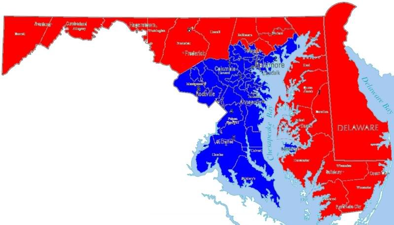
As in my April post, the map below demonstrates that it is very possible to redistrict Maryland in a manner in which eight Democrats can be elected to Congress from the state.  I have refined the map whereby seven Democratic districts (Districts 2, 3, 4, 5, 6, 7 and 8) voted for Obama by at least a 22.5 point margin.  Districts 4 and 7 remain African-American majority, as is necessary per the VRA.  (Both districts are ensured to elect an African-American Democrat, as 70% or more of the Democratic primary vote in each district is expected to be comprised of African-Americans.)  The proposed District 1 goes from one which McCain won by 18.5 points to one which Obama wins by 6.4 points; if Kratovil makes it through 2010, he will be more than safe in the new MD-1.  The proposed District 6 goes from one which McCain won by 17.5 points to one which Obama wins by 22.6 points.  In the discussion of each district (below the map) I also discuss how these new districts performed in other recent Maryland political races (2004, 2006 and 2008 elections).

Maryland Map:

Photobucket

Central Maryland Map:

Photobucket

Central Maryland Maps with precincts:

Photobucket

Photobucket

Photobucket

Note:  Additional supplemental maps can be found at bottom of diary.

Discussion of Individual Districts:

YELLOW – District 1:  Frank Kratovil (home: Queen Anne’s County)

Current District:  Obama 39.8%; McCain 58.3% (McCain + 18.5)

Proposed District:  Obama 52.3%; McCain 45.9% (Obama + 6.4)

Proposed District:  Kerry 47.9%; Bush 51.1%

Proposed District:  Cardin 45.6%; Steele 52.7%

Proposed District:  O’Malley 44.5%; Ehrlich 54.4%

This district continues to encompass the entire Eastern Shore.  The new district proceeds through parts of northern Harford and Baltimore Counties (although it completely excludes the State Senate District of 2008 GOP Candidate Andy Harris) and into very Democratic territory on the western side of Baltimore County.   The district also includes the Annapolis area in Anne Arundel County.  Interestingly, both the Obama-McCain and Kerry-Bush percentages of the new district correspond very closely to the national average.

Major communities in proposed MD-1 district: all of Eastern Shore; Harford County – Bel Air (part); Baltimore County – Randallstown, Lochearn, Milford Mill, Owings Mills, Reisterstown, Woodlawn (part); Anne Arundel County – Annapolis.

GRAY – District 2:  Dutch Ruppersberger (home: Cockeysville)

Current District:  Obama 59.8%; McCain 38.3% (Obama + 21.5)

Proposed District:  Obama 60.8%; McCain 37.5% (Obama + 23.3)

Proposed District:  Kerry 55.3%; Bush 43.8%

Proposed District:  Cardin 52.3%; Steele 45.9%

Proposed District:  O’Malley 51.0%; Ehrlich 47.8%

The new district continues to include most of the communities currently in MD-2, including parts of Anne Arundel, Harford and Baltimore Counties, as well as Baltimore City (the proposed district includes all areas of Baltimore City currently in MD-2 and also adds the area around Hopkins/Bayview Hospital on the eastern side of the city.)  The new district expands into parts of Prince George’s and Howard Counties.

Major communities in proposed MD-2 district: Baltimore City (part); Anne Arundel County – Brooklyn Park, Glen Burnie (part), Severn, Fort Meade, Odenton, Maryland City; Harford County – Bel Air (part), Fallston, Joppatowne, Edgewood, Aberdeen, Havre de Grace; Baltimore County – Cockeysville, Towson (part), Rosedale, Middle River (part), Essex (part), Dundalk (part); Prince George’s County – Laurel; Howard County – Savage-Guilford.

ORANGE – District 3:  John Sarbanes (home: Towson)

Current District:  Obama 58.8%; McCain 39.2% (Obama + 19.6)

Proposed District:  Obama 60.5%; McCain 38.0% (Obama + 22.5)

Proposed District:  Kerry 55.4%; Bush 43.8%

Proposed District:  Cardin 57.3%; Steele 40.9%

Proposed District:  O’Malley 52.4%; Ehrlich 46.2%

Like MD-2, the new MD-3 remains quite similar to the current district.  Most of the Baltimore City, Baltimore County and Howard County areas remain intact.  Additional territory in Baltimore Co., Howard County and Montgomery County is added.  The Anne Arundel County part of the current district is detached.

Major communities in proposed MD-3 district: Baltimore City (part); Baltimore County Towson (part), ParkvilleCarney, Pikesville, Timonium-Lutherville, Perry Hall, White Marsh, Arbutus, Lansdowne; Howard County – Elkridge, Ellicott City (part), Columbia, North Laurel; Montgomery County – Burtonsville, Colesville, Aspen Hill (part), Olney, Laytonsville.

RED – District 4:  Donna Edwards (home: Fort Washington)

Current District:  Obama 85.1%; McCain 14.2% (Obama + 70.9)

Proposed District:  Obama 70.7%; McCain 28.0% (Obama + 42.7)

Proposed District:  Kerry 64.0%; Bush 34.8%

Proposed District:  Cardin 60.7%; Steele 37.9%

Proposed District:  O’Malley 61.7%; Ehrlich 37.3%

Proposed District African-American: 51%

The new MD-4 continues to encompass much of the same Prince George’s County communities currently in the district.  The Montgomery County part of the current district is detached and is substituted by parts of Anne Arundel and Baltimore Counties; very Republican precincts from both counties are added, and the overall Democratic percentage of the district goes down a lot, but still stays at over 70% Obama (there is completely no need to have a district with an Obama advantage of 85-14 !).

Major communities in proposed MD-4 district: Prince Goerge’s County – Fort Washington (part), Oxon Hill, Temple Hills, Andrews AFB, Forestville, Largo-Kettering, Mitchelville, Glenarden, Bladensburg, Riverdale, Hyattsville (part), College Park (part), Langley Park, Adelphi, Beltsville; Anne Arundel County – Crownsville, Gambrills, Davidsonville (part), Millersville, Severna Park, Pasadena-Lake Shore, Riviera Beach, Glen Burnie (part), Ferndale, Linthicum; Baltimore County – Sparrows Point/Edgemere, Dundalk (part), Essex (part), Middle River (part).

PURPLE – District 5:  Steny Hoyer (home: Mechanicsville)

Current District:  Obama 65.4%; McCain 33.3% (Obama + 32.1)

Proposed District:  Obama 62.7%; McCain 36.0% (Obama + 26.7)

Proposed District:  Kerry 54.7%; Bush 44.5%

Proposed District:  Cardin 53.7%; Steele 45.0%

Proposed District:  O’Malley 54.3%; Ehrlich 44.7%

This district changes relatively very little.  It continues to encompass all of the three Southern Maryland counties, south Anne Arundel Co. and “outer” Prince George’s Co.  Parts of Upper Marlboro as well as Crofton and parts of the Annapolis and Broadneck peninsulas are added, while Laurel and adjoining parts of northern Prince George’s are taken out of the district.  The district becomes slightly less Democratic, but it still has a very healthy 26.7 point Obama advantage over McCain.

Major communities in proposed MD-5 district: All of Southern Maryland – Calvert County, Charles County, St. Mary’s County; Prince Goerge’s County – Fort Washington (part), Clinton, Upper Marlboro, Bowie, Glenn Dale, Greenbelt; Anne Arundel County – Riva, Edgewater, Davidsonville (part), Mayo, Shady Side, Deale, Parole/Annapolis, Arnold, Cape St. Claire, Crofton.

GREEN – District 6:  Roscoe Bartlett (home: Frederick)

Current District:  Obama 40.2%; McCain 57.7% (McCain + 17.5)

Proposed District:  Obama 60.3%; McCain 37.7% (Obama + 22.6)

Proposed District:  Kerry 54.3%; Bush 44.7%

Proposed District:  Cardin 54.5%; Steele 44.1%

Proposed District:  O’Malley 51.6%; Ehrlich 47.3%

The new district includes most of Frederick County, parts of Carroll County, as well as a good chunk of Montgomery County.  The new territory in Montgomery is the factor that dramatically changes the political composition of this district, as some of the most Democratic parts of the county are added to MD-6.

Major communities in proposed MD-6 district:  Frederick County – Frederick, Middletown, Thurmont, Emmitsburg, New Market, Mt. Airy; Carroll County – Taneytown, Manchester; Montgomery County – Damascus, Clarksburg, Germantown, Montgomery Village, Aspen Hill (part), Wheaton-Glenmont, White Oak, Silver Spring (part), Takoma Park (part).

BLUE – District 7:  Elijah Cummings (home: Baltimore City)

Current District:  Obama 78.8%; McCain 19.9% (Obama + 58.9)

Proposed District:  Obama 67.0%; McCain 31.5% (Obama + 35.5)

Proposed District:  Kerry 60.8%; Bush 37.9%

Proposed District:  Cardin 55.2%; Steele 42.8%

Proposed District:  O’Malley 55.2%; Ehrlich 43.1%

Proposed District African-American: 51%

The new MD-7 is not that different from the current district.  The Baltimore City portion of the district remains wholly intact, and, in fact, is expanded to include a few additional African-American majority neighborhoods (including the Pimlico and Coldspring areas in the northwestern part of the city).  The Catonsville and Woodlawn areas in western Baltimore County as well as a good portion of Howard County also remain with MD-7. New, more Republican areas in northern Baltimore County, and parts of Carroll and Harford Counties are added to the district.

Major communities in proposed MD-7 district:  Baltimore City (part); Baltimore County – Catonsville, Woodlawn (part); Harford County – Jarretsville; Carroll County – Westminster, Hampstead, Eldersburg, Sykesville; Howard County – Ellicott City (part).

PINK – District 8:  Chris Van Hollen (home: Kensington)

Current District:  Obama 73.9%; McCain 24.7% (Obama + 49.2)

Proposed District:  Obama 62.0%; McCain 36.2% (Obama + 25.8)

Proposed District:  Kerry 56.9%; Bush 41.6%

Proposed District:  Cardin 58.3%; Steele 40.4%

Proposed District:  O’Malley 55.0%; Ehrlich 44.0%

The new district includes most of Montgomery County, parts of Frederick and Prince George’s Counties, as well as all of the three Western Maryland counties.  The district becomes somewhat less Democratic, but the new MD-8 still has some of the state’s best partisan stats (4th best Obama percentage, after the two African-American majority districts, and just behind MD-5; 3rd best Kerry percentage; 3rd best O’Malley percentage – just slightly behind MD-7; and 2nd best Cardin percentage – behind only MD-4 and ahead of both MD-3, Cardin’s home district, and the new MD-7 !).

Major communities in proposed MD-8 district:  All of Western Maryland (Garrett County, Allegany County, Washington County); Frederick County – Brunswick; Montgomery County – Silver Spring (part), Takoma Park (part), Kensington, Chevy Chase, Bethesda, Potomac, Rockville, Gaithersburg, Poolesville; Prince George’s County – Hyattsville (part), Mt. Rainier, Cheverly, Seat Pleasant, Landover.  

Note:  for the entire plan above, the boundaries of only three precincts had to be changed slightly in order to make the map work: 26-7 and 26-11 in Baltimore City, and 4-11 in Baltimore County.

So that’s my Maryland Redistricting Plan – Version 2.  I welcome comments and discussion (if possible, could someone calculate the “PVI’s” for my “new” districts based on the numbers above; I’m not being lazy, just not exactly sure what the current definition is).

Maps of Presidential Performance 2008:

Photobucket

Photobucket

Baltimore City:

Photobucket

Btw, the Baltimore City precinct from the map above that voted 100% for Obama is 15-12, part of the Walbrook neighborhood !  (close-up map is below).  In addition, 47 other precincts in Baltimore City had Obama percentages of 99.0 to 99.9, while 48 voted for Obama at a 98.0 to 98.9% rate (there were also 32 precincts in Prince George’s County that had Obama percentages of between 98.0 and 98.9, and five that voted 99.0 to 99.9% for Obama).  I grew up in Baltimore and currently reside in Silver Spring, and am very proud to live in the great state of Maryland !

Photobucket

Redistricting Maryland: 8 Democratic Seats

The purpose of this diary is to demonstrate that it is quite possible to redistrict Maryland in a manner in which 8 Democrats can be elected to Congress from the state.

The following map provides a visual re. how this may be accomplished following the 2010 Census:

Photobucket

General Observations:

1.) I tried to make the new map reflective of 2010 population estimates, as different parts of the state have experienced varying population growth levels.  For example, the population of Baltimore City is expected to decline slightly between the 2000 and 2010 Censuses, while some outer exurban areas of Baltimore and Washington are expected to show increases of 20% or more.

2.) I tried to make the map less gerrymandered than the current one, and believe that I was successful at the task.  While still creative, the district boundaries are arguably more uniform and the districts more compact than before.  Additionally, the new map keeps intact much of the territory of the current 7 Democratic representatives, while still creating a new 8th Democratic seat.  I decided to keep the district boundaries exactly as they currently are in Baltimore City — in that way it will be much harder to challenge those lines (which are quite gerrymandered) in Court as the new district boundaries in Baltimore would do nothing more than preserve the status quo.

3.) Due to the VRA, the state has to preserve 2 African-American majority districts.  The new map does accomplish this task.  Both District 4 and District 7 are about 51% African-American, using projected 2010 population estimates.  The hitch here is that I use the Census definition of “African-American or in combination with other race(s)” while the standard to use may need to be “African-American alone” under which only about 49% of the population of each district would be black.  Nevertheless, as I’m using only projected population figures, it’s something that can be adjusted once the official 2010 numbers come out — think of the map here as sort of a blueprint of what can be done.  Both districts are ensured to elect an African-American Democrat, as 70% or more of the Democratic primary vote in each district is expected to be comprised of African-Americans.

4.)  I tried to preserve the Democratic nature of all the current Democratic-held districts.  As you can see from the map, and accompanying tables, in Districts 2, 3 and 5, the Democratic percentage — as measured by the share Obama received last year — remains basically the same (it should be noted that the numbers I use here don’t include an adjustment for absentees which would change them slightly).  In District 8, the Democratic percentage declines a bit more — approximately 3% — but still stays at about 70% Obama, which will keep the 8th in Democratic hands.  In Districts 4 and 7, the Democratic percentage drops significantly — from 85% to 73% in MD-4, and from 79% to 66% in MD-7, but the districts are still very Democratic (even John Kerry received close to 60% of the vote in 2004 under District 7’s new lines).  McCain would have won the new District 1 narrowly; however, the Democratic percentage surges from 40% Obama to 47% Obama.  If Kratovil can survive the 2010 election, this map will solidify him in 2012.  District 6 experiences the biggest changes.  The Democratic percentage goes from an anemic 40% to a robust 58.4% (basically equaling Districts 2 and 3).

Discussion of Individual Districts:

District 1:

This district continues to encompass the entire Eastern Shore.  The Republican Harford and Baltimore County portions of the district also remain.  The Anne Arundel Co. portion is taken out and substituted by hyper-Democratic territory currently in the 2nd (Randallstown) and 7th (Lochearn).  The new 1st is arguably less gerrymandered than the old one.  There is no more connection of parts of the district over the Bay Bridge, and the district encompasses one less county than before.

District 2:

The district continues to be anchored by Baltimore County — the boundaries change very slightly in that county.  The Harford County and Baltimore City boundaries don’t change at all.  The Anne Arundel Co. part remains similar to the current, though is less gerrymandered.  To substitute for the loss of the Randallstown area, the Laurel area is added instead.

District 3:

Like MD-2, the new 3rd remains quite similar to the current district.  The Baltimore City, Towson, Parkville Pikesville, Owings Mills, Reisterstown, and Arbutus areas remain intact, as well as the current Howard Co. portion of the district.  The remainder of Howard is added (whereby the whole county is now in MD-3).  The Mt. Airy area of Carroll and Frederick Counties is added as well as Catonsville in Baltimore Co. (Catonsville was in the district prior to 1992), while the highly gerrymandered Anne Arundel areas are taken out.

District 4:

The new 4th continues to encompass large portions of 2 counties.  Most of inner Prince George’s County continues to anchor the district.  However, Montgomery is detached and substituted by Anne Arundel — in fact, the most Republican parts of Anne Arundel.  The Democratic percentage thereby goes down a lot, but still stays at 72.5% Obama.

District 5:

Very little changes here.  Continues to encompass the 3 Southern Maryland counties, south Anne Arundel and outer Prince George’s.  The Annapolis area and parts of Upper Marlboro are substituted for Laurel and adjoining parts of northern PG.

District 6:

Continues to wholly encompass the 3 Western Maryland counties, as well as a good part of Frederick Co.  The hyper-Republican Carroll Co. and areas east are detached, while the district is extended further into Montgomery and PG — including some of the most Democratic parts of suburban DC, ie. Silver Spring, Takoma Park, Mt. Rainier, Cheverly and Landover.  The new district is not any less compact than before, and it now includes only all or part of 6 counties, instead of the current 7 counties.

District 7:

This district “looks” a bit different from the current one; however, population-wise, much of the district remains the same.  The entire Baltimore City portion of the district remains wholly intact, as well as the Woodlawn area of Baltimore County.  The suburban/exurban areas in Howard Co. are detached and substituted by even more exurban (and even more Republican) areas in Carroll, northern Baltimore Co. and northern Harford as well as the blue-leaning area encompassing the City of Frederick (all taken out of the current 6th District).

District 8:

Remains very similar to the current one.  Democratic areas, including Takoma Park, parts of Silver Spring and the PG portion of the district are taken out, while relatively more republican areas in northern Montgomery are attached.  The new 8th remains entirely within Montgomery County.

So that’s my map in a nutshell; I welcome comments and discussion.

We’ve Got Crabs! (or, Redistricting Maryland)

(From the diaries – promoted by DavidNYC)

None of you asked for Maryland, but I wanted to redraw a state in which I couldn’t use townships and incorporated municipalities as a crutch. Four of Maryland’s five largest communities are unincorporated – Columbia, Silver Spring, Ellicott City and Germantown.

Plus, having lived in Maryland for quite awhile, I wanted to do a state that I actually had a local feel for. Lastly, Democrats control both the General Assembly and the Governorship, so no quips about this map being “unrealistic”!

I apologize for the title ahead of time – I’ve seen tourist gear with that slogan one too many times flying out of BWI….

My goals:

  • Strengthen Kratovil (1st)

  • Pack Republicans into Bartlett (6th)

  • Keep all other Democrats at their previous levels or 65%, whichever is lower.

(When you have this many Democrats to protect….)

Anyways, here’s the map (click for full-size version):

Update: I realized I mis-merged some shapes in my GIS and this lead to a misrepresentation of the 1st and 5th in Anne Arundel County. Fixed.

So normally, there’d be a nice map of the state broken up by municipalities and colored in based on McCain/Obama performance. In Maryland, this was harder: I consolidated precincts to match up with Census 2000’s voting tabulation districts (VTDs). Sometimes, in cases where precincts changed significantly, I consolidated some VTDs, too. I’ve creatively named these consolidated VTDs “CVTDs”.

Also, tabulating data by CVTD is a pain in the ass. Seriously. So I only created CVTDs for counties that had a chance of being split. So here’s the map, colored by CVTD for some counties (I wasn’t going to split Calvert, St. Mary’s, the Eastern Shore, or the Panhandle).

District-by-district, here goes (numbers are: Population, Voters, %African American, Obama%, McCain%):


1 662,203 357,190 26.89% 56.48% 42.11%
Anne Arundel 117,748 65,392 20.21% 56.33% 41.93%
Caroline 29,772 13,218 14.77% 37.61% 60.64%
Cecil 85,951 42,494 3.91% 41.57% 56.14%
Dorchester 30,674 15,274 28.39% 45.25% 53.48%
Kent 19,197 10,020 17.41% 49.43% 48.95%
Prince George’s 148,552 87,295 59.27% 88.42% 10.86%
Queen Anne’s 40,563 24,045 8.78% 35.66% 62.74%
Somerset 24,747 9,924 41.10% 48.16% 50.76%
Talbot 33,812 20,328 15.36% 44.45% 54.09%
Wicomico 84,644 41,854 23.29% 46.44% 52.20%
Worcester 46,543 27,346 16.66% 41.59% 57.07%

This is the district we were all wondering about, Frank Kratovil’s 1st. Before, the 1st took in all of the Eastern Shore, a chunk each of Anne Arundel, Harford, and Baltimore counties. Those parts were absolutely brutal, so I removed the the BaltCo (35% Obama)/Harford (33% Obama) parts completely. Additionally, instead of taking in the Republican pats along the North Shore, the district runs through the city of Annapolis proper and into PG County. Yes, the district reaches across the bay, but the old district did this too. Plus now, I can use the Bay Bridge as an excuse, as both ascents to the bridge are in this district now. Obama lost the AA part of the district 39-59, but he won the reconfigured part of Anne Arundel 56-42. We weren’t going to more artfully draw Baltimore, so for Democratic strength, the new 1st looks to Prince George’s County – Obama’s 88-11 performance there anchors this district. Overall, Obama scored 56% here – up a whopping 16%.


2 662,315 309,805 25.58% 60.34% 37.71%
Baltimore 419,630 204,167 21.76% 57.30% 40.74%
Baltimore City 143,321 56,010 42.46% 79.02% 19.26%
Harford 99,364 49,628 17.36% 51.75% 46.08%

Dutch Ruppersberger’s district doesn’t change much – still the southern half of Harford, an arm across Northern BaltCo, and a section of the city. However, there’s no awkward arm across the Patapsco into Anne Arundel this time. The Harford section is a tad less Democratic, the BaltCo section a bit more, and Baltimore City a bit less. However, the removal of Anne Arundel bumps this district to 60%, up about 0.5%.


3 662,016 356,350 18.53% 60.69% 37.37%
Anne Arundel 108,683 57,529 17.90% 50.80% 47.30%
Baltimore 239,472 126,645 22.89% 61.92% 35.97%
Baltimore City 74,391 32,258 17.57% 72.34% 25.89%
Howard 239,470 139,918 14.76% 60.95% 37.20%

Surprisingly, I think this incarnation of the 3rd is less gerrymandered than before – there’s no one-block wide sliver connecting to distinct sections. The major change from before is the placement of almost all of Howard County into this district, which had been located mostly in the 7th. Instead of making a westward facing loop through Baltimore as before to hit Towson, this district makes an eastward facing U. Obama got 61%, up 2% from before.


4 661,820 293,331 51.60% 82.43% 16.65%
Montgomery 309,396 153,066 22.75% 71.41% 27.28%
Prince George’s 352,424 140,265 76.92% 94.46% 5.06%

Donna Edwards’ district also isn’t changed much. A large section of upcounty MontCo and Prince George’s along the DC line. With the 8th shifted northward, the 4th is a bit more Montgomery-heavy, but stays majority African-American. This shift drops Obama’s performance by about 3%, but this is still the most Democratic district in Maryland at 82%.


5 661,222 352,347 30.44% 64.23% 34.51%
Anne Arundel 79,363 47,288 5.90% 43.67% 54.55%
Calvert 74,563 44,057 13.11% 46.07% 52.42%
Charles 120,546 70,127 26.06% 62.22% 36.69%
Prince George’s 300,539 146,466 47.72% 83.78% 15.20%
St. Mary’s 86,211 44,409 13.92% 42.84% 55.63%

Steny Hoyer’s district, again, experiences some minor shifts. It still contains all of the Southern Maryland trifecta of Charles, Calvert, and St. Mary’s. I had thought about cracking Charles to tap its population growth and Democratic trend, but ultimately decided against it. A large chunk of PG is taken by the 1st, so this district expands farther into Anne Arundel. At 64%, this is about a 1% drop.


6 663,091 354,947 3.61% 35.44% 62.22%
Allegany 74,930 29,742 5.35% 35.95% 61.88%
Baltimore 50,784 32,008 1.36% 32.03% 65.08%
Carroll 150,897 84,760 2.28% 33.11% 64.30%
Frederick 97,113 54,983 2.06% 40.21% 57.86%
Garrett 29,846 12,872 0.43% 29.02% 69.17%
Harford 119,226 73,667 2.53% 31.04% 66.35%
Howard 8,372 5,315 4.60% 34.51% 63.03%
Washington 131,923 61,600 7.77% 42.61% 55.47%

We took some Republicans out of the 1st, 2nd, and 3rd districts, and this is where they go. I cut out Democratic-trending and sububanizing southern Frederick County and just packed as many deep-red VTDs in here as possible from Harford and northern Baltimore County. The Panhandle and Carroll County remain in their entirety. This drops Dem performance to 35%, down 5%.


7 661,710 265,229 55.65% 72.99% 25.62%
Anne Arundel 183,862 89,411 10.02% 42.84% 55.09%
Baltimore 44,406 18,118 10.72% 46.90% 50.51%
Baltimore City 433,442 157,700 79.60% 93.08% 6.05%

Before, this district took in a large chunk of Howard County, before reaching into Western BaltCo and West Baltimore. We took the extremely Republican parts of Anne Arundel County out of the 1st, and this was the safest place to deposit them. The anchor of the district stays Baltimore City, which also maintains the 56% African-American composition of the district. At 73% Obama, this is a drop-off of 6%, but again, no cause for concern.


8 662,109 342,398 10.92% 69.23% 29.27%
Frederick 98,164 56,203 10.62% 56.77% 41.56%
Montgomery 563,945 286,195 10.97% 71.68% 26.85%

It was tempting to make this district solely Montgomery County, but that’d well, be too clean. (It’d also abandon some strong Democratic votes in Frederick City.) Thus, this takes a bite out of Southern Frederick along 270, and then takes in the western half of Montgomery County and ventures east into Silver Spring. Frederick is nowhere as Democratic as downcounty Montgomery County, resulting in a 5% drop in Obama’s performance to 69%. Even if Frederick’s shift was a one-time thing for Obama, the vast majority of the district is still in Montgomery County.

So I’m pretty sure my map of Maryland is not only better – resulting an improvement for the three most marginal Democratic districts and negligible drops in the other 4 Democratic districts – but less gerrymandered, I dare say. Questions, comments, witty descriptors for what the districts look like, and suggestions always welcome.

MD-01: Why Frank Kratovil Can Win With Your Help

When incumbent GOP Representative Wayne Gilchrest lost his primary to a “Club for Growth” backed extremist, Maryland’s First Congressional District became competitive — and with help, could actually favor the Democratic candidate, Frank Kratovil.  When Blue Catapult PAC held an event for Frank, we learned that not only is he a great candidate, but that the dynamics of the district make it ripe for a Democratic pickup.

Why can MD-01 turn Blue?

    Frank is a Great Candidate. He is the current State’s Attorney for Queen Anne’s County, and he is in court in the morning and campaigns later in the day. Unlike his opponent, he is a native of Maryland’s Eastern Shore, which comprises about half the voters and are very protective of their congressional representation. Frank is a lifelong Democrat and was President of Maryland Young Democrats when he was younger. He is outspoken against the War and supports a sane fiscal policy.
    This is now an Open Seat. With the moderate Wayne Gilchrest losing his primary, the seat is now truly competitive. The district breaks down in Party ID to about 40% Democrat, 40% Republican and 20% independent. Gilchrest represented the district well with his moderation, including opposing the continuation of the War, and not always supporting Bush’s tax policies. As this is going to be a truly competitive seat, it should get most of the attention of Maryland’s Democratic political apparatus.

    Frank’s opponent is Too Conservative for the District. The right-wing 527 “Club for Growth” put in over $1 million in media and mailings in beating Gilchrest and will probably do more in the Fall. Gilchrest has not endorsed the man who beat him in the primary and some of his former staff are already helping Kratovil. The GOP candidate, Andy Harris, is a state representative who believes that taxes are too high and government should leave business alone. As Frank said to us on Tuesday, with all the problems in the country — the War, health care, the environment, etc. — all Harris talks about is taxes.Gilchrest’s independence fit the district well — Harris’ knee-jerk conservatism does not. he is alos from the Baltimore metropolitan area which will put Eastern Shore resident ill at ease.

    But to make this District blue, Frank needs your help. While his Cash on Hand at the end of last quarter was not far from Harris’, the Club for Growth spending will add unofficial troughs to his campaign. Once Frank gets his message out he should win — but he needs the resources to do that.

    Please Contribute to Frank Kratovil HERE

    Just $15, $20 or $30 will go a long way as the more funding Frank gets now, the more seriously the national party will take his campaign.
    Thank you.

    Please Contribute to Frank Kratovil HERE

MD-01: Help Frank Kratovil Tonight in DC with Senators Mikulski & Cardin

Frank Kratovil is the Democrat running for the seat currently held by GOP moderate Wayne Gilchrest who lost his primary. The current GOP nominee, Andy Harris, is an extreme right-wing, Club for Growth backed candidate who had hundreds of thousands of dollars spent on his behalf. Frank is a great candidate who is a solid Democrat — and with support can definitely win this district.

Tonight (Tuesday, May 13) Blue Catapult PAC and WNDC Pac will cohost a fundraiser for Frank Kratovil.  We are asking for minimum contributions of $35 — with the open wine/beer bar and food, it is a great deal.  Plus Senators Barbara Mikulski and Ben Cardin are expected to join us after votes.

Tuesday, May 13

6:30PM to 8:00PM

at the Woman’s National Democratic Club

1526 New Hampshire Ave, NW

Washington, DC 200036
On the corner of Q Street and New Hampshire Ave, NW-about 3 blocks east of the DuPont Circle North Metro Exit

If you might attend, please email frankevent [at] bluecatapult.com

If you can’t come, please consider a contribution to Frank’s campaign here:

http://www.actblue.com/page/bl…

Kratovil nearly equal Cash on Hand in MD-01

Despite being out raised significantly in the first quarter, Frank Kratovil is nearly equal in cash on hand to his Republican opponent Andy Harris. Harris likely raised and then squandered most of the money due to the fact that he had a competitive primary (Gilchrest) but nonetheless it was a bit surprising to us Marylanders that they were so close. Especially considering Harris had much more money on hand than Wayne Gilchrest and E.J. Pipkin for much of the primary.

http://www.politickermd.com/ed…

The article is wrong, Kratovil only has 170k cash on hand, it was corrected later today

Progressive politics on the ground

During the past few weeks, we’ve all watched the Republican party continue to implode. First Karl Rove resigned, then Alberto Gonzales’s reign at the Justice Department finally came to a close. This week, we saw another intolerant, far-right Republican exposed as a hypocrite.

But while these events might give us some encouragement, we’ve still got a lot of work ahead of us if we’re going to bring about real progressive change. In the DC area, local elections are beginning to ramp up, and these can go a long way in affecting communities. At Twenty-First Century Democrats, we’re jumping in and hitting the ground running to help progressive local candidates build the foundation for national change.

Our September schedule is packed. We’ll be helping out four different campaigns this month – knocking on doors, dropping literature and coordinating our results with the various campaigns we are supporting. Starting this Saturday, our team will be in Central Baltimore for an all day walk on behalf of Fred Mason III We’re working with SEIU/1199, the Baltimore Federation of Teachers, HERE/UNITE and the Victory Fund to get the vote out for the September 11 primary.  We’ll also spend two full days in Virginia on for Albert Pollard and Carlos Del Toro in Stafford County and in Fairfax for the Janet Oleszek campaign.

Every one of these candidates deserves our support. 

We believe that each of them, when elected, will carry progressive values and legislative smarts into their new jobs. We’ll keep you updated on our progress.

In the meantime, what local races are you interested in?

Thanks,
Shannon Scanlan
Twenty-First Century Democrats

A Graphic Anatomy of Victory: NJ, DE, MD (w/maps)

This is the third in a series of diaries graphically depicting the Democratic victory in this year’s midterm elections.

Today we will be looking at how the election went in New Jersey, Delaware, and Maryland.  No seats changed hands in these states, below are maps of the the current state of party control.

Of 1,822,786 votes cast in the 2006 New Jersey House races 983,747 votes (54%) were cast for Democrats while 815,871 votes (45%) were cast for Republican candidates.

In Maryland, 1,581,195 votes were cast with 1,017,276 (64.3%)for Democrats, while 544,508 votes (34.4%) were cast for Republicans.

In Delaware, the Republican candidate won with 57.2% of the vote.

Looking at vote margins, the only close race in these states was in the NJ-07 where the Republican candidate won by a margin of 3,259 votes (1.9%), with the Democratic candidate garnering 47.8% to the Republican’s 49.5%.   The Democratic 2006 performance is a 6.2% improvement over the 2004 Democratic vote share.  This should be a target for 2008.

Tier 0

Race      D%      R%     Margin    2006 D Cand.

No races meet the criteria for this tier.

Tier 1

Race      D%      R%     Margin    2006 D Cand.

NJ-07     47.8    49.5   1.7       Linda Stender

Tier 2

Race      D%      R%     Margin    2006 D Cand.

No races meet the criteria for this tier.