There’s already been a lot of analysis of the evolving political trends from 2004 to 2008 (including from me, although still nothing beats that widely-circulated New York Times county-change map) based on preliminary election returns. But with the exception of dreaminonempty‘s remarkable and must-see map diary over at Open Left, no one has really focused much on what longer-term trends look like, especially at the county-by-county level.
One question I was left with after this election was what areas have changed so much that they used to stick with the Democrats (or Republicans) even in their absolute darkest hour, but now favor Republicans (or Democrats). The darkest hour for Democrats was a pretty easy choice (Walter Mondale); for Republicans, I was initially thinking of Barry Goldwater, but his pre-Civil Rights Act map is just too different from today’s map to be useful, so I settled for the GOP’s second biggest recent failure, Bob Dole.
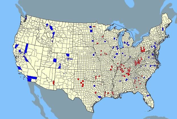
As I suspected, Mondale/McCain counties were clustered mostly in the same Appalachian swath where Obama underperformed the most at the statewide level; much of this transition is very recent, as a number of these counties (especially eastern Kentucky and western Pennsylvania) even went for Kerry. There were also some southern counties that are around 50/50 white/black, where enough white voters used to be yellow-dog Dixiecrats to put even Mondale barely over the edge, but collapses in white rural southern voting for Dems at the presidential level has allowed Republicans to take those counties more recently.
To my surprise, there were actually more Mondale/McCain counties than there were Dole/Obama counties. (In case any righties are trolling this article looking for some scraps of solace, there’s your takeaway: OBAMA UNDERPERFORMS MONDALE!!!) There are 97 Mondale/McCain counties, and only 85 Dole/Obama counties (or independent cities).
However, there’s a key difference. While the Mondale/McCain counties are rural and very small (and generally stagnating or getting smaller), the Dole/Obama counties include many of the nation’s largest population centers. The Mondale/McCain counties have a median 2000 population of 16,000, while the Dole/Obama counties have a median population of 103,000. The sum population of all Mondale/McCain counties? 3,197,000. For all Dole/Obama counties: 25,846,000. There’s pretty much the story of the 2008 election right there.
More specifically, there are only five Mondale/McCain counties with a 2000 census population over 100,000. Four are collar counties around Pittsburgh (Beaver, Fayette, Washington, and Westmoreland). These are counties that used to be manufacturing and coal-based union strongholds, hence the willingness to vote Dem even in the face of all that was Mondale. Unfortunately, these counties all share one common thread: little in-migration, and an elderly population aging in place (all of these counties are 17-18% 65+, a rate unseen pretty much anywhere else other than Florida)… and these counties become both smaller and more conservative each year as former unionists die off. (Bear in mind John Murtha’s comments too, as most of these counties are the core of his district.)
The fifth county is Anoka County in the Minneapolis suburbs, where there may have been something of a favorite son effect in 1984, but this is also an area where exurbanification and the mega-church religious right seems to be edging out traditional rural Lutheran Minnesota values (as seen by this county’s choice of congresscritter: Michelle Bachmann).
By contrast, the four largest Dole/Obama counties all have a population over one million: Harris (Houston) and Dallas in Texas, and San Diego and Riverside in California. These are all counties that are young, fast-growing, and most ominously for the GOP, are on the verge of tipping to Hispanic pluralities in the next decade.
Now maybe that can be shrugged off because California and Texas weren’t in play this year, but in the 800,000-1,000,000 population range are a number of swing counties in swing states that basically swung the election: Orange County, Florida (Orlando), Marion County, Indiana (Indianapolis), Hamilton County, Ohio (Cincinnati), and Fairfax County, Virginia (DC suburbs). And below that, fully 43 of the 85 Dole/Obama counties have populations over 100,000. Even the loss of the Pittsburgh-area collar counties can be more than compensated, population-wise, with the four eastern Pennsylvania counties that went Dole/Obama: Berks, Chester, Dauphin, and Monroe.
Here’s a map of the Mondale/McCain counties (in red) and the Dole/Obama counties (in blue):

Continue over the flip for full lists of the counties…
Mondale/McCain counties
AL: Colbert, Jackson, Lawrence
AZ: Greenlee
GA: Crawford, Greene, Marion, McIntosh, Mitchell, Taylor, Telfair, Webster, Williamson
IL: Franklin
IA: Dallas, Davis, Monroe, Ringgold
KY: Ballard, Breathitt, Floyd, Harlan, Knott, Letcher, Livingston, Lyon, Magoffin, Marshall, Morgan, Muhlenberg, Perry, Pike, Union, Webster
LA: Allen, Pointe Coupee, West Baton Rouge, West Feliciana
MI: Keweenaw
MN: Anoka, Chisago, Jackson, Pennington
MO: Mississippi, Oregon, Reynolds
NC: Tyrrell
OK: Coal, Haskell, Hughes
PA: Armstrong, Beaver, Fayette, Greene, Lawrence, Washington, Westmoreland
SC: Edgefield
TN: Benton, Cannon, DeKalb, Franklin, Grundy, Henry, Hickman, Humphreys, Lake, Lincoln, Overton, Perry, Robertson, Smith, Stewart, Trousdale, Van Buren, Warren, White
TX: Cottle, Dickens, Fisher, Morris, Newton, Orange, Robertson, Stonewall, Swisher
VA: Buchanan, Dickenson, Russell
WV: Brooke, Clay, Fayette, Hancock, Lincoln, Logan, Mingo, Wyoming
Dole/Obama counties
AL: Jefferson
CA: Alpine, Butte, Mono, Nevada, Riverside, San Diego, San Luis Obispo, Trinity
CO: Arapahoe, Jefferson, La Plata, Larimer, Ouray, San Juan
FL: Orange
GA: Douglas, Newton, Rockdale
ID: Teton
IL: Boone, Carroll, DuPage, Kane, Kendall, McHenry, McLean, Sangamon, Stephenson
IN: Marion, Tippecanoe
MD: Charles
MI: Berrien, Clinton, Eaton, Jackson, Kent, Leelanau
MN: Olmsted
MS: Oktibbeha
MT: Lake, Lewis & Clark, Gallatin
NE: Douglas, Lancaster
NV: Carson City, Washoe
NH: Belknap, Carroll
NJ: Somerset
NM: Los Alamos
NC: Forsyth, Pitt, Wake, Watauga, Wilson
ND: Cass, Grand Forks
OH: Hamilton
PA: Berks, Chester, Dauphin, Monroe
SC: Barnwell, Charleston
SD: Brookings
TX: Dallas, Harris
UT: Grand
VA: Albemarle, Chesapeake, Danville, Fairfax, Fairfax city, Harrisonburg, Henrico, Loudoun, Manassas, Manassas Park, Prince William, Staunton, Winchester
WA: Island
WI: Calumet, Waupaca

