Independent Redistricting NY Map

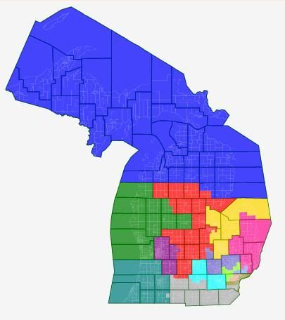
Ok, I drew this one of New York. This seems more likely to happen, as Cuomo has said he would veto any gerrymandered map. Also, if they pass an independent redistricting bill then this becomes a possibility too. Tried to split as few counties as possible. In NYC, protected the VRA districts of Clarke, Serrano, Meeks and Towns. With the majority-minority districts (Velasquez, Crowley) they move but keep that status. Tried not take incumbents into consideration at all.  

Photobucket

Ok lets start again in West NY:

Photobucket

27 (TEAL): Higgins gets a compact Buffalo based district. 62 % Obama. SAFE D

26 (BLACK): Chris Lee’s ex district. Sucks in all the area in between Rochester and Buffalo. 46% Obama. STRONG R.

5 (YELLOW): Slaughter gets a district which is most of Monroe County. Obama 58.5%. STRONG D. This could theoretically be competitive when Slaughter retires, but probably not.

25 (PINK): Finger lakes district for Tom Reed. Obama 46 %. STRONG R.

24 (PURPLE): District with Syracuse and Ithaca. Mayor of Syracuse would prob win this one. Obama 59%. Contains the SW portion of Richard Hanna’s district, but not his hometown of Utica. SAFE D

Photobucket

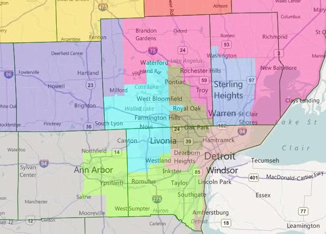
23 (LIGHT BLUE): This contains the 6 North Country counties, as well as Utica and Rome. Obama 52%. Richard Hanna would probably run here versus Bill Owens. Lean D.

20 (PALE PINK): This contains the adirondeck areas: Schnectedy, Saratoga Spring, Glens Falls and Lake George are here. Scott Murphy would probably run here. Chris Gibson currently represents this area, but lives in the Southern part of the district. Obama 49 %. TOSSUP.

Photobucket

22 (BROWN): Contains Binghamton and the Catskill area. Hinchey’s hometown of Ithaca is in the Syracuse district, but most of the area he represents is in this district. Dems might be better off with a different candidate though. Obama 54%. Lean D.

21 (MAROON): Contains Albany, Troy, and parts east of the Hudson down to Pougkipsie and Hyde Park. Gibson’s home is in this district. Tonko would probably be safe though in this Obama 58% district.

Photobucket

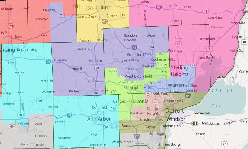
19: NYC Exurbs, most of Rockland, Dutchess, Orange county. Hayworth represents most of this area, even though her home is not in this district. She would probably run here rather than against Nita Lowey. Obama got 49 % here. Lean R due to Republican Incumbent.

Photobucket

18: All of Central and Northern Westchester, as well as the soundshore. The only part not includes are the southern cities of Yonkers, New Rochelle, Pelham and Mt. Vernon. Also goes over the Tappan-Zee Bridge to grab Nyack from Rockland County. Obama 60%. Safe D for Lowey.

Photobucket

17 (BLUE): Eliot Engel would probably run in this district. Contains Southern Westchester as well as  the Northern Bronx. Engel’s worry would be the primary here, as it is an 80 % Obama district. W 31 B 33 H 27 A 4.

16 (LIME): Serrano South Bronx district stays the same. Obama 95%. W 3 B 30 H 62 A 2.

15 (ORANGE): Rangels district moves a little further south in Manhattan, down to 90th St. Obama 92%. W 19 B 29 H 46.7

14 (PUKE): Takes in UES, UWS, Midtown, Greenwich Village area and some of Downtown. Obama 81 %. Maloney is safe here still.

9 (LIGHT BLUE): This district takes in some of Crowley’s former areas in the Bronx, as well as Flushing, Bayside, and part of Forest Hills NE of Queens Blvd.  Ackerman and Weiner would probably duke it out here, with Ackerman having repped most of this area but Weiner being more popular with the base. Weiner could also just retire and focus on his mayoral run. W 42 B 9 H 22 A 22 and Obama 68 %.

7 (SILVER): This district contains Astoria, Corona, Jackson Heights and Woodside. Has Crowley’s home and some of his area. Would probably face competition from Joel Peralta and maybe Mike Gianaris. Obama 78 % and W 27 B 8 H 41 A 20.

Photobucket

12 (LIGHT BLUE): Takes in some of Weiners old ground (Western Rockaway, SW Queens) and some of Velasquez’ area (Williamsburg, Brooklyn Heights etc). Obama 75 %, W 42 H 37 B 8 A 8. Not really sure who would win a primary here between Velasquez and Weiner, but this district may have more of Weiner’s district than the one based in Flushing.

11-10 (PINK AND GREEN), 6 (TURQUOISE): Towns and Yvette Clark’s (+Meeks) districts stay pretty much the same and above 50 % black. So they are good under the VRA.

8 (DARK BLUE): Takes in downtown Manhattan and Southern Brooklyn, taking in both Orthodox Jewish and Hispanic areas. Obama 65 % W 52 H 20 B 3 A 22. Nadler probably safe here, but could face a challenge from a more Brooklyn based primary challenger.

13 (SALMON): Takes in Staten Island as well as Coney Island, Sheepshead Bay and other heavily Russian areas in Brooklyn. Obama 49 %, probably a toss up between Grimm and McMahon in a likely 2012 rematch. A point more democratic than the current district.

Photobucket

4 (RED): McCarthy’s district takes in all the inner Nassau Suburbs and tiny piece of Queens. Obama 58 %.

3 (PURPLE): King loses his huge tendril into Suffolk, and therefore his district becomes much less Republican. The flip side of that is that Israel’s seat will be more Republican. Obama 51 %, LEAN R.

2 (GREEN): Israels district now solely in Suffolk county. Obama 53.5 %, as he has to take in some of King’s area’s from the South Shore. LEAN D

1 (BLUE): Bishop’s district stays the same. LEAN D. Obama 52%.

So what independent districting would do is give us one extra safe D seat in Syracuse, throw a Lean D race between Owens and Hanna, gives Scott Murphy a clear comeback shot, weakens Hinchey, King, Israel, and takes apart Gibson’s district and totally un-gerrymanders Queens.  

Ohio Redistricting 2011 – Incumbent Protection

So I know that this is redistricting season, and that Ohio has been done by many folks already, but I couldn’t let it go by without giving my feeling on how my home state might re-draw it’s congressional map.  

As we know, the Republicans are in total control of Ohio’s state government following what was an absolutely nightmare of a 2010 election cycle for the Democrats, both here and nationally.  Therefore they will draw the lines.  The following map is my best guess on what they will end up drawing ultimately.  

First of all though, I’m going to start by making a statement on what the Republicans should do, or at least what I would do if I were them.  Ohio is a swing state.  As we’ve seen in the past three cycles, it is especially vulnerable to wide swings in the electorate, going from 12-6 to 8-10 and back to 13-5 by the end of the decade.  What’s going on now is that John Kasich’s ratings are plummeting, mostly due to the fight between legislative Republicans and public employee unions.  Generic R is starting to falter against Generic D on the congressional ballot as well.  If I was a republican, I’d be wary of the potential of a sweep in 2012 by popular democratic Senator Sherrod Brown and Barack Obama atop the ticket in the Buckeye State, and would thus try to lock in as much of a wave-proof map as possible.  The best I feel the republicans can do against the democrats in a democratic year like 2006/2008 is 11-5 (maybe 10-6 if you have a big minority turnout in Cincinnati but you’ll be okay most years).  You get to 11-5 by ceding 4 Safe Dem seats in the north, one seat each centered around Toledo (Marcy Kaptur), Cleveland (Marcia Fudge), Akron (Betty Sutton), and Youngstown (Tim Ryan).  The 5th district would be a democratic vote sink surrounding Columbus in central Franklin County, and I would sacrifice Steve Stivers in order to accomplish that.  The reason for it is that, with as far leftward as Columbus is moving, it’s not feasible to keep splitting the county three ways as you’re going to lose at least 2 of them in a bad election cycle, making you worse off then if you sacrifice one.  

But anyways, that’s what I would do.  This map is about what they probably WILL do.  Some have called for a 13-3 attempt, but that would almost certainly be a dummymander of epic proportions.  So without further ado, here’s my prediction, a 12-4 setup in which districts 10 and 18 are eliminated:

Photobucket

District 1 – Dark Blue – Steve Chabot-R – This seat is centered around Cincinnati but includes a bigger section of republican Butler County, which is now about 1/4 of the district’s population.  It’s probable that Obama still won here, but this district certainly has a republican PVI now, maybe R+2, and Chabot would be favored to hold it in all but a really democratic year with high minority turnout like 2008.  You could really make this district safe R if you threw all of downtown Cincy into OH-2, but that would put Jean Schmidt onto the unemployment line more than likely.  

District 2 – Green – Jean Schmidt-R – This district is little changed geographically, but becomes slighly more democratic as it includes more of central Cincinnati and now has all of Scioto County, while losing parts of super-red Warren County.  PVI here is probably down to about R+8 or R+9 in order to shore up Chabot.  This seat would definitely be competitive in a normal or strong year for the democrats because of Schmidt’s suckiness, but a generic R would do fine here.  If Mean Jean can’t win an R+9, then that’s her own fault, and I think the state R’s will view things similarly.

District 3 – Purple – Mike Turner-R – This district is centered on Dayton, and extends a little further east than before while now holding all of Montgomery County.  It’s plausible that the PVI moved a point or so in the democrats’ favor, but honestly, Turner is iconic in Dayton and isn’t going anywhere.

District 4 – Red – Jim Jordan-R – District 4 moves a little bit further north and to the east but outside of that remains very rural and very republican, probably the most republican district in the state, it’s close between it and district 8.

District 5 – Yellow – Bob Latta-R – This seat makes me a little bit nervous from the republican perspective for a couple of reasons.  First of all, a lot of the rural counties in northwest Ohio are turning blue.  Secondly, because of immense population loss, Latta’s district now extends into Cleveland’s suburban reaches.  And not just exurby red areas either, but some democratic strongholds like Oberlin and Elyria in Lorain county.  I can’t take just red areas in Medina and Wayne either because it would hurt Jim Renacci.  The PVI here is still probably R+5 or R+6, but this one could be very interesting in a democratic year or by the end of the decade if NW Ohio keeps trending blue.

District 6 – Black – Bill Johnson-R – This is probably one of the tougher holds of any R district in the state.  Freshman Bill Johnson’s seat is mostly unchanged, but does gain a few R-leaning areas in the southern tier, like Jackson and Vinton counties.  It also loses a few democratic areas in Mahoning County.  The PVI probably moves by a point or two toward the republicans.

District 7 – Gray – Steve Austria-R – If there’s anybody that’s most unhappy with this plan, it’s most likely Steve Austria.  You see, I’m very concerned about Columbus, and as such, I felt it necessary to split the city more effectively 3 ways, which takes Austria’s district further into Franklin County.  In return I took Clark County, which is rather swingish, out of the district.  Still, district 7 is likely R+4 or R+5 now, and could be in play in a strong democratic year.  Austria should be okay if he campaigns well.

District 8 – Lavender – John Boehner-R – This district extends northward a bit to compensate for losing parts of Montgomery County, but it’s still extremely republican.  No trouble at all for the speaker.  

District 9 – Light Blue – Marcy Kaptur-D – This district turned out surprisingly well, and basically hugs the Lake Erie coastline stretching from Toledo’s west side over to some of Cleveland’s western suburbs like Lorain and Avon Lake.  It’s still an extremely democratic district, and an easy hold for Kaptur or any democrat.  

District 10 – Maroon – Betty Sutton-D vs Dennis Kucinich-D – Here we have a district that takes in most of Cleveland’s western suburbs, parts of northern Medina county, and the western half of greater Akron.  It’s actually quite similar to Sutton’s current district except that it takes in more of Cuyahoga and loses Lorain county to Kaptur/Latta.  Dennis Kucinich was actually drawn into Fudge’s district but he would undoubtedly run here instead as most of his base is within this version of OH-10.  I think Sutton would be favored to win a head to head primary as Kucinich has far too many enemies.

District 11 – Light Green – Marcia Fudge-D – Here’s Fudge’s district, fully within Cuyahoga County, and a 50% black VRA district at that, hugely democratic.  There’s still a possibility that the republicans will draw this district down toward Akron, but in the interest of compactness I didn’t feel it necessary.  It’s not like doing so would change the overall PVIs in the northeast very much.  

District 12 – Royal Blue – Patrick Tiberi-R – Tiberi’s district is strengthened here as it loses some areas in Franklin County and gains some republican-leaning areas around Zanesville and the Licking Valley.  This seat goes up to about an R+3 or so if I had to guess, which probably averts the seat going blue for awhile outside of a really strong democratic wave.

District 13 – Pink – Tim Ryan-D – This district is virtually unchanged, and still runs from Youngstown over to eastern Akron.  It’s still very solidly democratic for Ryan, or any democrat for that matter.

District 14 – Brown – Steven LaTourette-R – Sidebar, I have a special place for Steven LaTourette because when he was my congressman in 2001 he took my 8th grade class on the House floor.  That was a really cool experience.  Anyway, this district is another republican challenge because it’s squeezed on one side by Cleveland, on another by Akron, and on another by Youngstown.  The best I could do for LaTourette is move the seat into some republican-leaning suburbs in Cuyahoga like Lyndhurst, Brecksville, and Broadview Heights, and in Summit like Sagamore Hills and Peninsula.  I couldn’t avoid throwing in greater portions of Trumbull and Portage counties though, which hurts.  The PVI is most likely unchanged, so LaTourette should be fine, but this would be a real fight in an open seat.  

District 15 – Orange – Steve Stivers-R – This district is definitely the most worrisome for the Republicans as it has a democratic PVI, and I wasn’t able to do very much to change that here.  The district still contains just two rural counties plus a roughly 50% slice of Franklin County.  The good news is that Stivers has outperformed his district in his first two elections here, so he might be able to survive even if 2012 isn’t a great year for the republicans.  Between the three central Ohio republicans, Stivers, Tiberi, and Austria, Stivers gets the short straw as the freshman.  

District 16 – Sea Green – Jim Renacci-R vs Bob Gibbs-R – This last district has changed a bit as well, shifting southward mostly.  Holmes County, the most republican county in Ohio, is added, along with some swingy territory further south in Coshocton and Tuscarawas.  Overall I don’t think the PVI changes much, maybe a point further to the right for R+5.  Both Renacci and Gibbs have their bases of support within the district, so a primary between the two freshmen would be a cool fight to see.  

In Conclusion – A 12-4 map would be fairly hard to maintain for the republicans, but it’s one that could hold up in a neutral year if all their members fought hard and campaigned well.  I would say that based on this configuration, Stivers is the most vulnerable, followed by Chabot, then Johnson third.  On the flip side, the best the democrats could hope to do under a map like this is 10-6, by taking out Stivers, Chabot, Johnson, Tiberi, Schmidt (because of her unique weakness), and the Renacci/Gibbs primary winner.  I suppose if LaTourette were to retire then his could be in play as well.  With the exception of Stivers though, all of the republicans districts have an R-leaning PVI, which is what the other side should be shooting for.

Washington Redistricting: How About a Majority-Minority District?

Here’s an interesting proposal from some Seattle-area activists: a majority-minority district in the Seattle area.

That could be done, just barely, by combining Southeast Seattle with the suburbs south of the city, where the minority population has exploded over the past decade.

The Win/Win Network, a nonprofit group, drew up the potential “majority people of color” district and plans to submit it to the Washington State Redistricting Commission, the bipartisan panel charged with redrawing the state’s political map this year.

It isn’t as convoluted-looking as you’d think, but it would violate tradition (and usual redistricting commission policy) by splitting Seattle down the middle. (You can see the map at the link.) While north Seattle — maybe the likeliest place outside of Sweden to see a Volvo-on-Volvo traffic accident — is what makes Seattle one of the whitest major cities, south Seattle is very diverse and if you add in its close-in southern suburbs, you literally get to 50.1%. Whether this actually gets forced into being is a big VRA-related puzzle, though; while recent case law (like Bartlett v. Strickland) has dealt with districts where a minority’s share doesn’t reach 50%, I’m not aware of any cases on the issue of creating minority districts where the share tops 50% but it’s a tossed salad of all possible minorities. The implications of that issue could be huge, especially for redistricting California this year.

If you haven’t seen the New York Times’ newest version of its remarkable Census map (now updated with 2010 count data to replace ’05-’09 ACS data), the Seattle example is a neat place to start, especially if you’re having trouble conceiving of the Seattle area as diverse. Go to the dot-based racial distribution map, and find Census tract 281, just north of the airport. This may actually be the most racially balanced tract in the whole nation, more so than anything in Queens or the East Bay, based on my puttering around the map: it’s 26% white, 24% black, 19% Hispanic, and 22% Asian. In fact, here’s a challenge/rainy day activity for you all: if you can find anything more balanced, let us know in comments! (Sorry, no babka.)

This opens up a can of worms in terms of what’s most “balanced,” though, depending on how many races you want to talk about. Tract 919 in Flushing, Queens, is 27% white, 33% Hispanic, and 33% Asian (but only 4% black)… or if you want to go with a 5-way split, check out Tract 9603 (Nanakuli, on the west shore of the island of Oahu), which is 12% white, 18% Hispanic, 17% Asian, 30% multiracial, and 20% Native Hawaiian! I don’t want to limit how you define “balanced,” so feel free to point out any interesting tracts that you find.

UPDATE: I’ve found at least one that seems to beat that Seattle-area tract: it’s Census tract 355108 in Antioch, California (in Contra Costa County): 25% white, 24% black, 24% Hispanic, and 20% Asian.

Moderates vs. Independents Part I (Introduction, 2010 chart)

So I'm sure that everyone here is familiar with the simplistic analysis about Independents, that they're all swing voters, that they're all somehow supporting something coherent, that they are, like their namesake, completely independent from either political party. Savvy political analysists have long understood that the number of truly Independent voters is a lot smaller than the self-identification numbers suggest, but that doesn't stop even the most savvy of political analysists from assuming that Independent = Moderate. Not only is this wrong, it's actually the case that even moderate voters are not the swing voters that the media makes them out to be.

For example, would it surprise you to learn that in 2010, when Republicans absolutely destroyed Democrats in the House, Democrats won moderates 55-43? Or maybe you'd be interested to learn that Blanche Lincoln, after losing the election to John Boozman by 21 points that she had won moderates by 14 points.

Independents, as one might expect, went very big for the Republicans, favoring them to the Democrats by a 56-37 point margin. This should serve as a strong reminder as to why Independents are not moderates and why moderates aren't necessarily swing voters.

To read the chart that's below the fold, the Independent/Moderate numbers are the percentages that Democratic candidates got, the comparison is how much more Democratic the moderate vote was compared to the Independent vote. The final number is how well the Democratic candidate did among moderates relative to Independents. The only races here are ones with exit poll data from 2010 (hence why DE-AL and VT-AL are part of the data).Also the Y and N show whether or not the Democratic candidate won the moderate vote. Also, in the case of FL-Sen, I combined Crist's numbers and Meeks's numbers together for purposes of this analysis. Alvin Greene's numbers in South Carolina are also his own, but it's also worth mentioning that 13% of the moderate vote went to the Green nominee, Tom Clemonts, meaning that the combined moderate vote in South Carolina went 53% against DeMint even as the vote went 63-37 for him.

And without further ado, the data:

  Independent Moderate Comparison   Mod won? D vote  Mod compared to actual vote
AZ-Sen 29% 45% 16%   N 35% 10%
AZ-Gov 40% 59% 19%   Y 43% 16%
AR-Sen 25% 55% 30%   Y 37% 18%
AR-Gov 59% 79% 20%   Y 64% 15%
CA-Sen 42% 58% 16%   Y 52% 6%
CA-Gov 42% 59% 17%   Y 54% 5%
CO-Sen 37% 60% 23%   Y 48% 12%
CO-Gov 39% 64% 25%   Y 51% 13%
CT-Sen 48% 56% 8%   Y 55% 1%
CT-Gov 38% 50% 12%   Y 49% 1%
DE-Sen 48% 66% 18%   Y 56% 10%
DE-AL 47% 66% 19%   Y 57% 9%
FL-Sen 48% 64% 16%   Y 50% 14%
FL-Gov 44% 60% 16%   Y 48% 12%
HI-Sen 69% 83% 14%   Y 75% 8%
HI-Gov 51% 59% 8%   Y 58% 1%
IL-Sen 28% 51% 23%   Y 47% 4%
IL-Gov 29% 51% 22%   Y 47% 4%
IN-Sen 34% 52% 18%   Y 40% 12%
IA-Sen 28% 42% 14%   N 33% 9%
IA-Gov 41% 55% 14%   Y 43% 12%
KY-Sen 42% 57% 15%   Y 44% 13%
LA-Sen 32% 48% 16%   Y 38% 10%
MO-Sen 31% 52% 21%   Y 41% 11%
NV-Sen 44% 66% 22%   Y 50% 16%
NV-Gov 32% 53% 21%   Y 41% 12%
NH-Sen 35% 43% 8%   N 37% 6%
NH-Gov 53% 68% 15%   Y 53% 15%
NY-Sen 54% 75% 21%   Y 66% 9%
NY-Sen* 50% 69% 19%   Y 63% 6%
NY-Gov 49% 71% 22%   Y 63% 8%
OH-Sen 27% 48% 21%   Y 39% 9%
OH-Gov 37% 58% 21%   Y 47% 11%
OR-Sen 47% 61% 14%   Y 57% 4%
OR-Gov 43% 52% 9%   Y 49% 3%
PA-Sen 45% 60% 15%   Y 49% 11%
PA-Gov 41% 53% 12%   Y 46% 7%
SC-Sen 14% 40% 26%   N 28% 12%
SC-Gov 41% 63% 22%   Y 47% 16%
TX-Gov 40% 62% 22%   Y 42% 20%
VT-Sen 68% 68% 0%   Y 64% 4%
VT-Gov 51% 42% -9%   N 50% -8%
VT-AL 69% 66% -3%   Y 65% 1%
WA-Sen 41% 57% 16%   Y 52% 5%
WV-Sen 51% 67% 16%   Y 54% 13%
WI-Sen 43% 58% 15%   Y 47% 11%
WI-Gov 42% 56% 14%   Y 47% 9%
 Average 42.30% 58.45% 16.15%   Y 49.38% 9.06%

SSP Daily Digest: 3/28

Senate:

HI-Sen: Ex-Rep. Ed Case said he expects to decide by “mid-April” whether he’ll seek Hawaii’s open Senate seat. Case also says that the Merriman River Group took a poll for him and claims he kicked ass in both the primary and general-but he’s only released a couple of selected toplines (click the link if you want them). PPP will have an HI-Sen general election poll out on behalf of Daily Kos/SEIU in the next couple of days.

ME-Sen: Democrat Hannah Pingree, former Speaker of the state House and daughter of 1st CD Rep. Chellie Pingree, left the state legislature earlier this year. Only 34, she’s lately been managing the family’s inn & restaurant and serving on a local school board, so she seems like a good potential candidate to run for office once again-perhaps even to challenge Sen. Olympia Snowe. But Pingree just gave birth to her first child a week ago, which probably makes her less likely to get back into the game this year.

MI-Sen: A GOP operative passes along word to Dave Catanese that Pete Hoekstra is turning down the chance to appear at some Lincoln Day dinners-which this source thinks is a sign that Hoekstra isn’t planning to run for Senate. Hoekstra’s would-be pollster (the same guy who was basically spinning lies about PPP last week) vociferously disputes this interpretation. We’ll see, but I personally think Hoekstra is going to tell us he plans to spend more time building turtle fences with his family.

MT-Sen: Activist Melinda Gopher says she is contemplating a primary challenge to Dem Sen. Jon Tester. She explains her reasoning here. She received 21% of the vote and finished third in the Dem primary for MT-AL last year. I could not find any FEC reports for her.

ND-Sen, ND-AL: Another good catch by Greg Giroux: ex-Rep. Earl Pomeroy (D) just closed his federal campaign account. While it’s not dispositive, of course, this probably means he’s not interested in seeking his old seat, or the retiring Kent Conrad’s spot in the Senate. Note that Pomeroy didn’t completely slam the door on a gubernatorial run, but I’m guessing that’s not terribly likely, either.

NM-Sen: New Mexico’s Republican Lt. Gov., John Sanchez, sounded very much like a candidate on a recent trip to DC. He spent some time slagging ex-Rep. Heather Wilson (the only declared candidate so far) in an interview with The Hill, criticizing her moderate credentials, but also being careful to try to put a little daylight between himself and the teabaggers. Sanchez indicated he’d decide “in the spring,” and perhaps hinted he’d announce on or around April 15th… because it’s totally not teabaggish to make a fetish out of Tax Day. He also says he’ll be back in Washington next week to meet with the NRSC (this trip was occasioned by a gathering of the all-important National Lieutenant Governors Association).

House:

FL-22: Ex-Rep. Ron Klein (D) definitively slammed the door on a rematch this cycle, saying he’s “looking forward to the private sector” (he’s taking a job with the law firm of Holland & Knight). But he did hold out the possibility he might return to office some day (he’s only 53). The same article also mentions a new possible Democratic candidate (despite the entrance of West Palm Beach Mayor Lois Frankel in recent days): state Rep. Joseph Abruzzo, who says he’s keeping his options open. (Abruzzo, hardly alone among Democrats, backed Charlie Crist over Kendrick Meek in last year’s Senate race.)

In other news, a firm called Viewpoint Florida released a very questionable poll pitting Rep. Allen West against Frankel. Really, the only reason you’d put out a survey of a district which is guaranteed to get reshaped is because you’re hoping to set a narrative among people who don’t know better (like, say, the tradmed… this piece doesn’t even mention the word “redistricting”). In addition, the poll is way too Republican, and also purports to be of “likely” voters, about one billion years before election day.

MI-09 (?): The question mark is there because who knows what districts are going to look like, or where state Rep. Marty Knollenberg-who says he’s considering a run for Congress-will wind up when all is said and done. That name ought to sound familiar: Marty’s dad is, of course, George McFly ex-Rep. Joe Knollenberg, who lost to current 9th CD Rep. (and potential redistricting victim) Gary Peters in 2008. Of note, Marty sits on a redistricting committee in the state lege, so maybe a House race is his… density.

NY-25: This is the kind of news I like to hear! Dan Maffei, who lost a heart-breaker last year, sent an email to supporters saying that he is “strongly considering running again” for his old seat. Maffei was always a great vote and a strong progressive voice, despite his decision to take a job after the election with the annoying “moderate” group Third Way. (I don’t begrudge the guy needing to eat, though, and the market was pretty saturated with one-term Democratic ex-Congressmen in need of a job.) We don’t know how this district will wind up, of course, but I’d be surprised if there were nowhere for Maffei to run.

NY-26: Teabagger David Bellavia looks pretty doomed-despite having enough signatures (in theory), he failed to file a key piece of paperwork with the Board of Elections, which will probably terminate his candidacy. It’s all the more poignant because, according to this article, the other campaigns said they would not challenge his signatures-and seeing as he submitted just 100 more than the 3,500 target, it’s a good bet he was in the danger zone. (Is it really true that Republican Jane Corwin said this, though?)

Speaking of Corwin, she’s got a third ad out, once again returning to small business themes (as she did in her first spot), rather than the negative attacks in her second ad.

PA-17: Tim Holden could be in that rare bucket of Democrats who might not actually benefit from their seats being made bluer in redistricting. The conservative Holden could have Lackawanna County added to his district, according to a possible GOP plan, which might open him up to a primary challenge from the left. It would also move a couple of ambitious pols from the county into his district, including Lackawanna County Commissioner Corey O’Brien (who attempted to primary ex-Rep. Paul Kanjorski last year) and Scranton Mayor Chris Doherty. PoliticsPA also says that Holden’s 2010 primary challenger, activist Sheila Dow-Ford, is “rumored” to be considering another run. (Dow-Ford lost 65-35 in a race fueled in large part by Holden’s vote against healthcare reform.)

VA-05: Last cycle, few establishment figures were as absolutely hated by the teabaggers as now-Rep. Robert Hurt. He won his primary with just 48%, against a typically fractured People’s Front of Judea/Judean People’s Front field. (We really need an acronym for that. PFJJPF, anyone?) The teabaggers have now taken to protesting Hurt’s votes in favor of continuing budget resolutions outside of his district office, but given their feeble efforts to unite around a standard-bearer last time, I’m skeptical that they have the organizational power to threaten Hurt next year.

Other Races:

Wisconsin Sup. Ct.: The Greater Wisconsin Committee is running a very negative new ad against Republican Justice David Prosser, accusing him of refusing to prosecute a child-molesting priest back when he was a D.A.-and explaining that the same priest went on to molest other kids after a parish transfer.

Remainders:

Census: New York City pols, led by His Bloomberginess, got wiggy almost immediately after seeing the Census Bureau’s largely stagnant new population figures for the city. Pretty much everyone is convinced that NYC grew by more than 2.1%, because, they say, the bureau undercounted immigrants. And here’s a pretty good supporting piece of data: The city added 170,000 new homes over the last decade, so how could it grow by only 166,000 people? (There are no huge swaths of abandoned properties in New York, though the Census does claim vacancies increased.) As a result, city officials are planning to challenge the figures (which they think should be about a quarter million higher). But it’s worth noting that a similar challenge 20 years ago wound up failing.

Votes: The New York Times is getting into the party unity score game, finding that (according to their methodology) 14 Dems have voted with Team Blue less than 70% of the time this Congress. It’s pretty much just a list of the remaining white conservative Blue Dogs who sit in red districts, though three names from bluer districts stand out: Dennis Cardoza (CA-18); Jim Costa (CA-20); and Gary Peters (MI-09).

Redistricting Roundup:

Louisiana: A state Senate committee passed a plan for redistricting its own lines last Thursday; a vote by the full body could come this week. Notably, the new map increases the number of majority-minority districts from 10 to 11. Things are delayed on the House side, though.

Virginia: A teachable moment in Virginia: Democrats in the state Senate adopted a rule that would limit the population variance in any new maps to no more than ±2%, while Republicans in the state House are using a ±1% standard. This issue often comes up in comments, but it’s simple: For state legislatures, courts have said that a 10% total deviation is an acceptable rule of thumb-that is, if the difference in population between the largest district and the smallest district is no more than ±5% of the size of an ideal district, then you’re okay. However, at least one map which tried to egregiously take advantage of this guideline (total deviation of 9.98%) was nonetheless invalidated, so while the “ten percent rule” is still probably a reasonable safe harbor, it may not be a sure thing. For congressional maps, it’s even simpler: Districts have to be perfectly equipopulous unless the state can justify the difference as necessary to achieve legitimate state policy. (For instance, Iowa state law forbids splitting counties to draw a federal map; this is considered an acceptable goal by the courts, so Iowa’s districts have slight variances.)

A Republican Hawaii

Given the condition of Hawaiian politics the title of the diary may seem laughably oxymoronic. Nevertheless there areas exist in Hawaii where Republican votes are more concentrated than others. Given Obama’s marked birth-state advantage in Hawaii I used Bush/Kerry numbers for calculations.  

CD1(Blue): 47.6% Kerry 16/9/53/20 W/H/A/O

Most of Oahu, particularly the more Republican parts.

CD2(Green): 58.4% Kerry 29/9/42/20 W/H/A/O

South-eastern Oahu and all of the other Hawaiian islands.

It is possible to make CD1 a point or two more republican if VRA requirements are ignored. However CD1 would now be a fair fight district giving the rare Hawaiian Republican a much better chance of winning without relying on no-primary vote splitting jungle elections.  

Multivariate analysis of Wisconsin polling data

(This is cross-posted at Daily Kos)

A couple weeks ago, Kos/PPP polled all the Wisconsin Republicans up for recall and found some very interesting results. However, he did not poll the Dem races up for recall, as well as the statewide upcoming Supreme Court race. In an attempt to rectify this fault, although I’m no Poblano, I decided to try to use multivariate regression to try and model the Wisconsin polling data using information from each district.

Fortunately, the dynamics of the race were much simpler than Clinton vs. Obama 2008, and I found in the end that the polling results could be described by only two variables (which is very nice, as we only had eight data points, so the model shouldn’t be overfitted):

1. Obama: The percentage of the vote Obama received in 2008 (Courtesy of SSP)

2. Incumbency: The number of years the person has been in office (for instance, someone elected in 2008 would have an Incumbency of 2 years.) – Numbers from SSP above.

I also experimented with other variables (which I discarded in the end as being not statistically significant):

3. Barrett: The percentage of the vote Tom Barrett received in 2010. (Thanks to the Journal-Sentinel)

4. Scandal: A 1/0 value describing the unique circumstances of the aptly named Randy Hopper, and perhaps Mr. Prosser as well.

5. Kerry: Percentage of the vote Kerry received in 2004

I also decided on using percentages rather than margins as there was a better correlation between the two.

In the end, my 2-variable model describes very accurately (within +/- 1.5%) the percentage of voters who would commit to voting for a Democrat in a hypothetical election this year; the spreadsheet is included below.


(The main prediction is highlighted in red. There are other columns to the right which include the additional variables that did not turn out to be significant.)

In short, the vulnerability of each Senator is based mostly off of Obama’s performance in the state in 2008, along with a small bonus from incumbency (about 0.3 points per year in office.) Thus, Hopper is quite vulnerable simply from being a freshman (the scandal had not impacted his poll numbers at that point yet), while Alberta Darling has built up goodwill from being in office for 18 years.

Extrapolating this model for the three Democrats who are considered semi-vulnerable, we find they are mostly safe. The only one who’s really vulnerable is Mr. Holperin, who was first elected by 2.5% in 2008 and represents a seat Obama won by single digits. Note that I give the Democrats negative incumbency so it gives a bonus to the D #s (rather than a penalty), and since the model considers undecideds, anything 48% or up is probably leaning D.

Examining Justice Prosser, who gets elected by the State of Wisconsin as a whole, we find that the seat is probably somewhat leaning D at this point, but I would put the margin of error much higher on this estimate – the race is still developing, and a Supreme Court race is very different from a Senate one.

Maryland Legislature

Now that the Census numbers are out and the Maryland prison population has been “reallocated” in accordance with a new law here (well, mostly reallocated — http://planning.maryland.gov/P… ….) I wanted to do a diary showing how Democrats can still be added to the Maryland Legislature despite the fact that Baltimore City is set to lose one district to the more Republican northeastern part of the state.  This map is also done in a manner where there are as few county splits as possible and I likewise tried to keep communities within counties in the same district.

I only drew districts for areas outside Montgomery and Prince George’s Counties and Baltimore City.  Those three jurisdictions are hyper-Democratic (combined vote 81.2 Obama – 17.7 McCain) and should have no trouble electing only Democrats.  The only trick there will be to balance the interests of the incumbent Democrats and the interests of minority communities.

Maryland’s Legislative redistricting should actually be quite easy this time around.  Due to a random mathematical quirk, a very large proportion of counties and regions of the state can be redrawn whereby very few districts need to cross county lines.  I made most of my new districts have a population deviation of +/- 3.5% (although most are +/- 2.5%), which is better than the +/- 5% deviation that has been used in the past.  (A few of the sub-districts here deviate up to +/- 4.5%.)  I have also made the new districts reflect the population adjustments required by a new Maryland law that reassigns the prison population from place of incarceration to last known address —  http://planning.maryland.gov/P…

You can see what I mean below:

The ideal district population this time around is 122,813 (for sub-districts it equates to 81,875 and/or 40,938).

– Baltimore City corresponds to exactly 5 districts with 125,333 persons each (2.1% above ideal).

– Montgomery Co. corresponds to exactly 8 districts with 121,542 persons each (1.0% below ideal).

– Prince George’s Co. corresponds to exactly 7 districts with 123,589 persons each (0.6% above ideal).

– Harford Co. corresponds to exactly 2 districts with 122,697 persons each (0.1 % below ideal).

– Frederick Co. and the three western Maryland counties correspond to exactly 4 districts with 119,727 persons each (2.5% below ideal).

– Baltimore and Carroll Counties together correspond to exactly 8 districts with 121,744 persons each (0.9% below ideal).

– Charles and St. Mary’s Counties together correspond to exactly 2 districts with 126,073 persons each (2.7% above ideal).

– Cecil and Kent Counties together correspond to exactly 1 district with 121,553 persons (1.0% below ideal).

– The lower Eastern Shore (5 counties including Caroline) corresponds to exactly 2 districts with 120,223 persons each (2.1% below ideal).

At this point, what’s left is only Calvert, Anne Arundel and Howard Counties on the western shore and Talbot and Queen Anne’s on the eastern shore.  Crossing as few county lines as possible was the reason why I drew a district across the Bay Bridge linking Talbot and Queen Anne’s with the Broadneck  Peninsula in Anne Arundel (one of the eastern shore districts has to cross somewhere, so why not here).  Anne Arundel still has 4 districts that are all or mostly in the county, while 2 more cross over with Calvert and Howard.  Howard itself has 2 that are completely within the county.  I drew separate sub-districts for those parts of Anne Arundel shared with Howard, Calvert and the Eastern Shore.

The main way I get more Democrats is the following two major changes:

1.) In Howard, the new District 9 becomes a whole lot more Democratic — new district is 60.1 Obama – 38.0 McCain — while the current district is only around 43 Obama.

2.) In Anne Arundel the new District 31 becomes a whole lot more Democratic — new 53.7 Obama – 44.3 McCain (but the Democratic 2006-2008 partisan numbers look even better there: 57.9 Dem. – 42.1 GOP) — while the current district is only around 40 Obama.

Here’s the map:

Photobucket

Photobucket

As I’ve said before, I didn’t even mess with Montgomery, Prince George’s and Baltimore City for the purpose of this diary which is to show how to draw the lines so more Democrats are elected — those three combined will have 20 Democratic Senators and 60 Democratic Delegates.  The lines can easily be drawn where all 5 Baltimore City districts are 60%+ African-American, and the Maryland suburban districts can likewise be drawn to reflect the great ethnic and racial diversity there.  

Virtually all other existing Democratic districts remain roughly at the same Democratic percentage or better.  Basically, to improve Democratic chances, I made the Dem-held districts more Democratic while making the GOP-held ones even more Republican, while still adding the two new Democratic seats discussed above.

The suburban districts in Baltimore Co. are all redrawn whereby the 6 districts going clock-wise around Baltimore City will all elect as many Democrats as possible (all the Republicans are packed into District 7 in the northern and eastern extremity of the county).

There is one district where the Democratic percentage would decline by a lot – District 27 which is the home of Senate Leader Mike Miller.  The new 27th would no longer have southern Prince George’s to make it more Democratic, but on the flip side, Miller would no longer need to fear a black primary challenger while his district would remain at 50.0 Dem – 50.0 GOP (2006-2008 partisan aggregate) – enough for him to win the general, as his “conserva-Dem” persona would fit the Calvert-based district perfectly.

Now to brief discussion of individual districts:

Western Maryland and Frederick Co.

District 1 – remains GOP, 65.3 McCain, 32.7 Obama

Sub-district 1A – 1 Delegate, Cumberland and Frostburg, made to be more Democratic, 55.6 McCain, 42.0 Obama (current sub-district is only about 34 Obama)

Sub-district 1B – 2 Delegates, 69.6 McCain, 28.5 Obama

District 2 – remains GOP, 53.4 McCain, 44.7 Obama

Sub-district 2A – 1 Delegate, Hagerstown, 56.5 Obama, 41.4 McCain (same as current sub-district)

Sub-district 2B – 2 Delegates, 57.6 McCain, 40.5 Obama

District 3 – made more Democratic, 56.5 Obama, 41.8 McCain (current district is about 54 Obama), sub-districts eliminated so that all 3 Delegates can now be Democrats

District 4 – remains GOP, 58.3 McCain, 39.9 Obama

Baltimore Co. and Carroll Co.

District 5 – remains GOP, 65.7 McCain, 31.6 Obama

District 6 – remains the “conserva-Dem” district that it is, 52.7 McCain, 44.7 Obama (BUT, 58.0 Dem – 42.0 GOP avg. 2006-2008), which is same as current district.

District 7 – remains GOP, 62.3 McCain, 35.1 Obama

District 8 – made to be more Democratic in order to add Delegates here, 52.2 Obama, 45.4 McCain (current district is around 48 Obama)

District 10 – new district is 69.1% black, 88.0 Obama, 11.1 McCain

District 11 – remains Democratic, 55.5 Obama, 42.6 McCain (but 59.3 Dem – 40.7 GOP avg. 2006-2008), less Democratic than current but should be plenty safe here

Sub-district 11A – 2 Delegates mostly Jewish areas in northwestern Baltimore Co., 62.4 Obama, 35.9 McCain

Sub-district 11B – 1 Delegate, Westminster area in Carroll Co., 60.9 McCain, 36.6 Obama, this is really a bone thrown to the GOP as District 11 could be left without sub-districts and would then elect 3 Democratic Delegates

District 12 – remains Democratic, 59.4 Obama, 38.3 McCain (slightly more Democratic than current)

District 42 – remains as is, Democratic Senator here now should be OK, hopefully a few more Democratic Delegates are added; the elections here have been very close in recent past, 53.0 Obama, 44.6 McCain (same as current district)

Howard County

District 9 – made to be much more Democratic, 60.1 Obama, 38.0 McCain. Current district is only around 43 Obama so Democratic Senator and 3 Democratic Delegates are added !

District 13 – remains Democratic, 60.4 Obama, 37.9 McCain (somewhat less Democratic than current, but should still be very safe)

Anne Arundel County

District 30 – remains Democratic, 53.0 Obama, 45.4 McCain (a bit more Democratic than current, so hopefully the lone GOP Delegate will be ousted)

District 31 – made to be much more Democratic, 53.7 Obama, 44.3 McCain (but 57.9 Dem – 42.1 GOP avg. 2006-2008).  Current district is only around 40 Obama so Democratic Senator and 3 Democratic Delegates are added !  (and bye, bye to the odious Don Dwyer).  Most of the Democrats who now represent District 32 could really run here, as much of the territory in the current 32 becomes part of the new 31; I could have just flipped the numbering here … For the first time in decades Glen Burnie would now all be in one district.

District 32 – remains Democratic, 55.3 Obama, 42.7 McCain (slightly more Democratic than current)

Sub-district 32A – 2 Delegates, Anne Arundel Co., 55.8 Obama, 42.3 McCain

Sub-district 32B – 1 Delegate, Howard Co., 54.3 Obama, 43.5 McCain

District 33 – remains GOP, 60.9 McCain, 37.0 Obama

Southern Maryland

District 27 – drawn for Senate Leader Mike Miller, 54.2 McCain, 44.2 Obama (but exactly 50.0-50.0 Dem/GOP avg. 2006-2008, with exactly 10 more votes for the Dems !) – current district is ofcourse a whole lot more Democratic as it goes into Prince George’s but in order to preserve the little or no county splitting goal, this is the only way to draw here.  As I mentioned above, Miller may not be against drawing the lines this way.

Sub-district 27A – 2 Delegates, Calvert Co. (except Dunkirk), 52.2 McCain, 46.2 Obama (but 51.9 Dem – 48.1 GOP avg. 2006-2008), would continue to be a swing area as currently

Sub-district 27B – 1 Delegate, Anne Arundel Co. (and Dunkirk in Calvert), 58.0 McCain, 40.3 Obama

District 28 – remains Democratic, 67.8 Obama, 31.3 McCain, new district is 44.5 white, 43.6 black

District 29 – remains the conserva-Dem swing area that it currently is, 55.5 McCain, 43.1 Obama (but 51.2 Dem – 48.8 GOP avg. 2006-2008) – about the same as current

Harford County

District 35 – remains GOP, 67.0 McCain, 30.4 Obama

District 46 – this district is “moved” here from Baltimore City, 50.0 Obama, 47.9 McCain (but 53.8 Dem – 46.2 GOP avg. 2006-2008), so should be a lean-Democratic district

Eastern Shore

District 34 – GOP Senator would remain, 55.1 McCain, 42.7 Obama

Sub-district 34A – 1 Delegate, 62.3 McCain, 35.3 Obama

Sub-district 34B – 2 Delegates, 51.4 McCain, 46.6 Obama (but 49.5 Dem – 50.5 GOP avg. 2006-2008), so area would be competitive

District 36 – remains GOP, 56.9 McCain, 41.4 Obama

Sub-district 36A – 2 Delegates, Queen Anne’s and Talbot Counties, 59.3 McCain, 39.2 Obama

Sub-district 36B – 1 Delegate, Anne Arundel Co. – Broadneck peninsula (Arnold and Cape St. Claire), 52.6 McCain, 45.4 Obama

District 37 – remains GOP, 59.2 McCain, 39.3 Obama

District 38 – reconfigured to shore up newly-elected Democratic Senator here, 50.4 McCain, 48.3 Obama (current district is only about 41 Obama)

Sub-district 38A – 1 Delegate, majority-black, 68.5 Obama, 30.3 McCain

Sub-district 38B – 2 Delegates, 58.3 McCain, 40.4 Obama

Michigan Redistricting: An Unexpected Problem

Maintaining two VRA majority-African-American districts in the metro Detroit area is going to be much more of pain than I originally thought. In the relevant population by CD thread, I breezily commented:

And, on an even more important “not-to-mention” note, the Detroit metro area still has more than enough African Americans for two VRA districts, so consolidating MI-13 and MI-14 isn’t in the cards quite yet.

This is not untrue, but the measures required to get those two districts were a lot more dramatic than I expected. The most recent Census estimates painted a very different picture from the actual Census’s report of massive population loss in Wayne County. And so the new districts are likely to be quite different from what I (and others) had previously imagined.

After the jump, I present two different scenarios for the Detroit area districts. Please feel free to post your own — this is very much more about getting a discussion going than presenting anything close to a polished proposal.

Map 1: Skirting the Line

So far as I can tell, this is the best you can do in terms of maximizing the African American percentages of the two Detroit districts while staying in Wayne County. However, the two Detroit districts are majority African American by total population, but not by VAP. So to the best of my understanding of current case law, this solution is VRA-suspect.

Which is unfortunate for the GOP, because this is reasonably successful map for them. Basically, this is an attempt to cut out both Dingell and Peters, while replacing one of their districts with a new safe Ann Arbor plus Lansing district.

District-by-district, briefly:

Benishek’s MI-01 (Blue) is shored up for the Republicans with the addition of Grand Traverse County. Likewise, Upton’s MI-06 (teal) gains Allegan County. Amash’s MI-03 (purple) holds more or less steady, as does Miller’s MI-10 (pink).

Huizenga’s MI-02 (green) – currently the most Republican district – absorbs a couple of problematic counties from Camp’s MI-04 (red). MI-04 is a little shaky for the Republicans, but I’m not sure how to fix that.

Walberg’s MI-07 (grey) loses Eaton and outer Washtenaw County and picks up Monroe County and the southern tier of Wayne County – I could be wrong, but my instincts tells me that’s a wash. Kildee’s MI-05 (yellow) stretches north to take in more of the Thumb and all of Bay County, which marginally weakens it for the Democrats. MI-09 (cyan) is a new heavily Democratic open seat stretching from Ann Arbor to Lansing.

Then, we move into the Detroit Metro area. Massive population loss in Detroit causes Conyer’s MI-14 (brown) and Clarke’s MI-13 (salmon) to chew up most of the Wayne County portions of Dingell’s dismantled MI-15. They’re 50.6% African American total pop, 49.6% VAP and 50.3% African American total pop, 49.5% VAP respectively. Levin’s MI-12 (cornflower blue) stays more or less the same, picking up the rest of Royal Oak from Peter’s dismantled version of MI-09.

Speaking of which, that’s been bisected between McCotter’s MI-11 (lime) and Rogers’s MI-08 (slate blue). McCotter picks up Peters himself and some of the more Republican parts of the dismantled Ninth. Rogers gets some of the most Democratic parts of the old ninth in West Bloomfield, Pontiac, and Auburn Hills — but he no longer has to worry about Lansing, so he should still be fine.

Map 2: The Problem of Pontiac


Same thing, just zoomed in with locality lines

This one really just focuses on the two Detroit districts. In contrast to the first map, you’re looking at two true majority African-American districts. MI-13 (salmon) is 53.0% African American on both measures. MI-14 (brown) is 56.5% African American by total population, 54.6% African American by VAP.

So far as I can tell, stretching Conyers’s district over into Oakland County like this to pick up Southfield and Oak Park is the only way to get the two Detroit districts to combine into majority-African-American status. Having done that, stretching up to majority-African-American Pontiac seems to make a lot of sense.

Having Clarke’s district stretch through Dingell’s Dearborn to get to majority-African-American Inkster isn’t strictly necessary to get to 50% African American by VAP, but it does help.

Now, if I’m right in my understanding of case law and this basic configuration is necessary to comply with the requirements of the VRA, then state GOP has a problem on its hands. They can’t draw a district for McCotter that (1) he can win and (2) conforms with state redistricting standards.

Michigan state redistricting standards frown on county and locality splitting and are generally understood to prohibit what user rdelbov generally calls a “double-cross” — that is, having Districts X and Y share both Counties A and B. If you look over the current map, you’ll see that interpretation seems to have been followed under the last GOP gerrymander. McCotter’s district is the one allocated Oakland-Wayne split district. If Conyers’s district becomes one, then McCotter’s district, under state redistricting standards, can’t do that any more. But McCotter lives in Wayne County, and he needs those Oakland County Republicans to have a winnnable district.

Now, the potential out here is that, so far as I understand it, the state Supreme Court basically declared the state redistricting standards non-justiciable the last time a suit was filed based on them after the 2000 round of redistricting. So if the GOP wants to ignore them, they probably can.

I drew in sample districts around the two Detroit districts. The Detroit metro area ones more of less work, from a GOP perspective, although some of the non-pictured outstate ones were pretty ugly. But without knowing how to resolve the “double-cross” conundrum, I wasn’t really sure how to proceed.

Wrap-Up

So, which is the better way for the GOP to push the limits of redistricing law? Two only-borderline majority African American districts in Detroit? Or violate (potentially unenforceable) state law and have two districts cross the Oakland-Wayne border? Or do you have a better solution altogether?

NY Stand-pat Map

I basically tried to put together a NY standpat map, which could happen if Gov. Cuomo backs down from his threat to veto any gerrymandered map. The Senate Republicans passed a constitutional amendment for non-partisan redistricting, which would only take affect in 2022. I guess this could also be a judges map, if the judges just wanted to keep everything pretty much the same. I just tinkered with the edges in NYC, not wanted to run afoul of the VRA. The upstate areas I tried to clean up the map, save the Plattsburgh to Syracuse district for Bill Owens. The map takes apart NY-05 and NY-25.

Photobucket

Ok starting in Western NY:

Photobucket

27: Higgins get a compact district, solely in Buffalo. Safe as well, Obama won with 62%. (TEAL)

26: The special election winner for Chris Lee’s old district gets a Obama 46% district. It eats up the Slaughter earmuffs and Chautauqua County. (SLATE)

5: Slaughter gets a compact district in her home Monroe County (I just called this NY-05 because Gary Ackerman’s district evaporated). This is an Obama 58 % district. (YELLOW)

25: Tom Reed’s district takes a chunk of Richard Hanna’s blue-color district, as that compacts towards Hanna’s home in the Utica area. Gets some of the area’s around Ithaca. Obama 47.5%. (RED)

Photobucket

23: Richard Hanna’s district is now cleaner and more centered around Utica. It picks up some area from Bill Owens’ district and Gibson’s. Obama 49%. (INDIGO)

21: Paul Tonko picks up a Greene county from Gibson in what is now an Obama 57% district. (DARK BROWN)

Photobucket

This is NY-23, which now runs from Owens’ home in Plattsburgh to Syracuse. He is probably safe with an Obama 58% district. He may be vulnerable to a primary challenge however from a Syracuse based politician. Gibson gets a few of the counties up north here.

Photobucket

22: Hinchey picks up all of Delaware county.  He keeps the tendril to Ithaca and picks up a little area in Orange county. Obama 58% (LIGHT BROWN)

20: The southern half of Gibson’s district doesn’t change much. It stays swingy, Obama won it with 52.5 %. (PINK)

19: Hayworth district picks up part of Nita Lowey’s district that had been in Rockland county, the area north of New City. Obama 51% (GREEN)

Photobucket

18: Nita Lowey gets a solely Westchester based seat. She loses her areas in Rockland to Engel and Hayworth and picks up New Rochelle, Mount Vernon and parts of Yonkers from Engel. Still safe, Obama 64% (YELLOW)

17: Engel picks up New City from Lowey, as well as some areas strongly Democratic from Joe Crowley in the Bronx. This becomes a Rockland/Bronx/Yonkers district. Obama 72% (BLUE)

Photobucket

7: Crowley’s district loses some Hispanic areas of the Bronx, but retains the more White, eastern area of it. He gets parts of Flushing, Great Neck and Elmhurst as well. While this is a minority-majority district, Crowley holds immense power as head of the Queens Democratic Party, so he would probably be safe from a primary. Obama 71 %, W 33 B 9 H 33 A 21 (SILVER)

16: Jose Serrano’s district grabs a few precincts to its east. Stays mostly same though. Obama 88 %, 62% Hispanic.  (GREEN)

15: Charlie Rangel’s district stays pretty much the same, just picks up a few blocks on the UES and UWS. Obama won 92 % here. B 30 H 47, so this may be won by Senator Espillat whenever Rangel leaves. (ORANGE)

14: Maloney picks up little more area in Queens, but other than that, no major changes. Obama 78%. (OLIVE)

Photobucket

9: Anthony Weiner’s district pulls out of Brooklyn for the most part. I had to give him a little chunk to the West of Marine Park, but other than that this is a Queens district (Weiner lives in Forest Hills). He picks up a big chunk of Ackermans old district in the Flushing area and Corona. Obama 64%, W 47 H 25 A 18 (LIGHT BLUE)

6: Meeks district picks up a little bit of the area from Ackerman. They are mostly white voters, and my map couldnt keep him above 50 % black voters for this VRA district. I’m sure its possible though, but its just darn hard. 88 % Obama, 49.9 % Black. (TEAL)

10: Towns’ district gives some Hispanic areas to Velasquez in the North, and picks up some White areas from Weiner’s old Brooklyn area near Marine Park. Obama 86% B 56 H 15 (LIGHT RED)

11: Yvette Clark picks up a little bit of Weiner’s district as she moves slightly south. 88 % Obama, 55 % Black.

12: Velasquez expands a little bit in the Williamsburg area. This inches slightly closer to a majority hispanic district. Obama 56 %, W 24 B 10 H 48 A 15. (LIGHT BLUE)

8: Nadler’s district stays the same, snaking from Manhattan to Boro Park, but he adds all of Coney Island as well from Weiner. Obama 72 % (DARK BLUE)

13: Michael Grimm picks up a few more Brooklyn Precincts from Weiner. Obama 49 % (SALMON)

Photobucket

This is where Ackerman gets taken out.

4: McCarthy takes a tiny piece of Queens, as well as the Southern half of Ackerman’s Nassau portion. Obama 58 % (DARK RED)

3: Peter King picks up Port Washington and Great Neck and keeps his weird tendril to grab Republican voters in Suffolk. Obama 48.5% (PURPLE)

2-1: Steve Israel’s district goes a little farther into Nassau county (GREEN: Obama 56 %) as Bishop (BLUE: Obama 52 %) grabs a little more Suffolk County territory to make up for population loss.

All in all, most of the republicans that won in 2010 stay within a point or two of where they were before. Hanna gets safer, Higgins becomes safe, Slaughter loses a few points of PVI but gets to be in her home base of Rochester. The map gets a lot cleaner upstate, few counties are split. All the congressmen in this map would be okay with very few new constituents, and the Dems would not be giving safe seats to all the republicans that just own their seats.