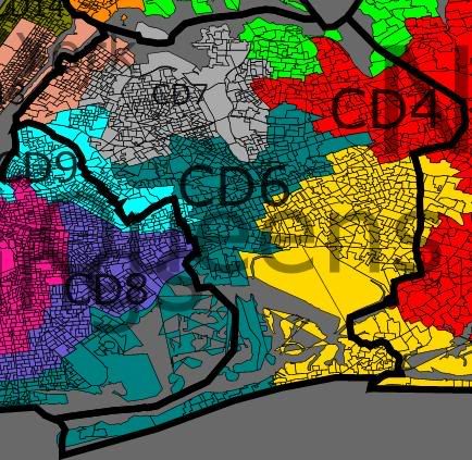
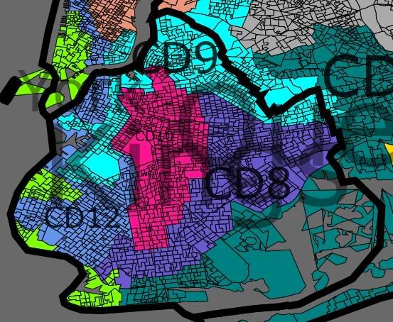
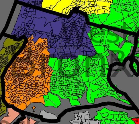
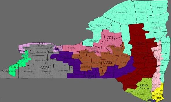
I experienced technical difficulties trying to generate JPEGs, and had to run an update on my computer which left me unable to get any images up before midnight, although I did email my .drf file to Jeff before the deadline. I understand if the lack of timely posted images leaves me ineligible for babka. 🙂 It’s my fault for trying to post on the last night of the contest, I realize. I now have a statewide map, but my area maps are coming up very weird.
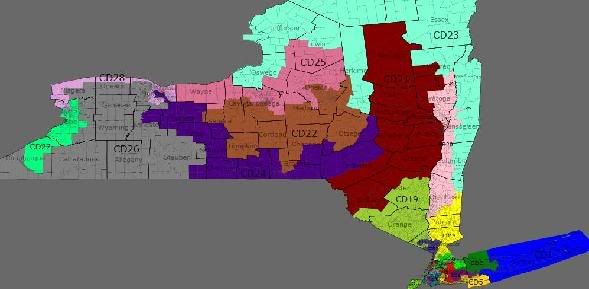
This 27-1 map has all 27 Democratic districts with at least 56% Obama voters. All districts are contiguous over either land or bridges to the best of my knowledge. Specific bridges are noted in particular district descriptions.
Unfortunately, I do agree that this looks fairly gerrymandered, but in other respects I like it.
I have 8,941 voters unaccounted-for that I have been unable to find even using the “next unassigned” tool. Nonetheless, I have gotten all deviations from the theoretically proper district population within the maximum one percent.
New York State image:

I am going to make further efforts tomorrow or later to generate better area maps, but I think this contest entry may fail for lack of technical acumen on my part. Still, I offer these districts for whatever value they may provide the SSP community; hopefully there’s enough in this diary to at least help Jeff make sense of my .drf file.
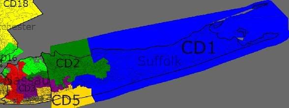
District 1: Tim Bishop’s district, and remains rooted in his Southhampton base. Instead of comprising all of eastern Suffolk, however, it omits much of the northern shore of Long Island and wends its way through Brookhaven and Smithtown into Islip.
Strengthened from 52%-48% Obama-McCain under the current districts to 56%-43% Obama-McCain. 73% White, 15% Hispanic, 7% Black, 3% Asian, 2% Other. Total population 699,044.
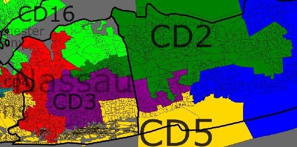
District 2: Steve Israel’s district, which remains centered in his Huntington home base of northwestern Suffolk County (with the exception of the very shore), and includes much of Smithtown in northwestern Suffolk as well, but then tunnels through southern Suffolk County and central Nassau County to reach Jackson Heights, and portions of Corona and Flushing in Queens.
Strengthened from 56%-43% Obama-McCain under the current districts to 57%-42% Obama-McCain. 54% White, 23% Hispanic, 15% Asian, 6% Black, 2% Other. Total population 700,293.
District 3: the approximate successor to Carolyn McCarthy’s current District 4, although significantly rearranged. Part of the plan to screw Peter King, whose district has essentially disappeared and who would need to choose between running in any of districts 2 through 6, or 8, none of which are weaker than 57% Obama. I believe this district may contain Carolyn McCarthy’s home in Mineola, although I am not certain, and adjustments might be necessary. In addition to Mineola, it takes in a substantial portion of central and southern Nassau County, a Democratic area of western Nassau close to the border with Queens, some neighborhoods of eastern Queens such as the Floral Park and Fresh Meadows areas, much of the south shore of Suffolk County, and Republican-leaning chunk of Brookhaven in central Suffolk County. Along with districts 4, 8, and possibly 2 and 5, it may contain Peter King’s home.
Like McCarthy’s current 58%-41% Obama-McCain district, this is 59%-41% Obama-McCain. 66% White, 14% Black, 12% Hispanic, 6% Asian, 2% Other. Total population 700,743.
District 4: the majority-black successor to Gregory Meeks’ current District 6. Still based around Jamaica, St. Albans, Springfield Gardens, and Meeks’ home in Far Rockaway. Crosses the border into Nassau County with two distinct “tentacles” serving three purposes, however. The northern protrusion into Nassau County takes in some majority-black areas just over the border and some Republican areas slightly further in to central Nassau. The southern tentacle takes in Rockaway to create a land bridge to Far Rockaway and include some heavily Republican areas nearby as well, and then incorporates Republican areas near the southern shore reaching all the way out to around Peter King’s Seaford / Oyster Bay home. It may or may not include that home.
Weakened from Meeks’ current 89%-11% Obama-McCain to 76%-24% Obama-McCain, but this should not put Meeks in any serious jeopardy. 51% Black, 29% White, 11% Hispanic, 4% Asian, 5% Other. Total population 698,468.
District 5: the successor to Gary Ackerman’s current District 5. Still includes northern Nassau, including his Roslyn Heights home area, and reaches into Flushing and other portions of northern Queens just like his current district. The Queens segment is longer and narrower, however, reaching all the way across the borough past Flushing and through LaGuardia Airport and East Elmhurst to Astoria. And the Long Island segment extends further out, taking in much of what is now the northern part of Peter King’s district in northeastern Nassau County, and also crossing over to Babylon in southwestern Suffolk County. Peter King’s home may be included at that crossover point, although it is probably to the south.
Slightly weakened from Ackerman’s current 63%-36% Obama-McCain to 58%-42% Obama-McCain, but Ackerman should still be OK. 69% White, 12% Hispanic, 11% Asian, 6% Black, 2% Other. Total population 699,091.
District 6: the successor to Anthony Weiner’s current District 9. Includes much of Forest Hills and nearby portions of Queens (the boundaries may need to be tweaked to include his exact home address), the Ozone Park and Howard Beach areas of Queens, and some Republican areas of southeastern Brooklyn such as Brighton Beach, Manhattan Beach, and Sheepshead Bay. Also extends a tentacle into Nassau County to take in some Republican areas of western-central Nassau.
Strengthened from Weiner’s current 55%-44% Obama-McCain to 58%-41% Obama-McCain, befitting Weiner recent liberal stands and to increase the odds of holding the seat if he becomes Mayor of NYC. 52% White, 18% Hispanic, 17% Asian, 7% Black, 6% Other. Total population 697,614.
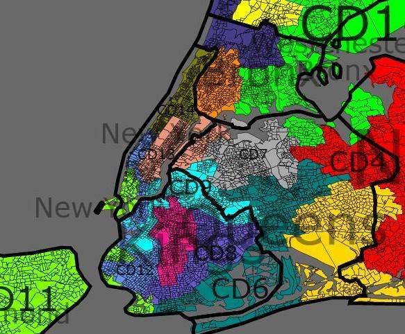
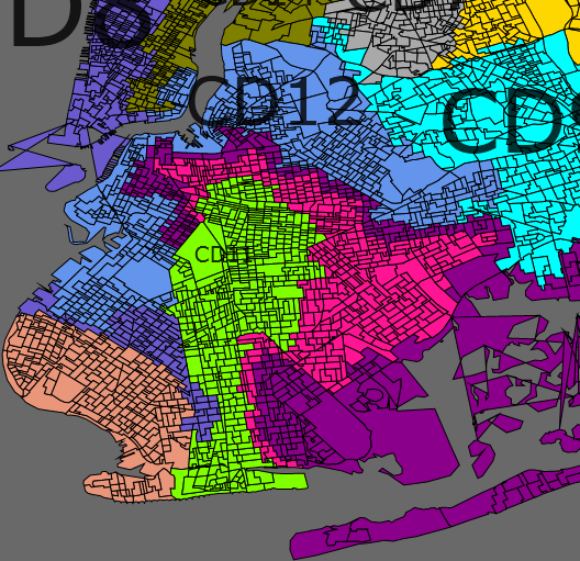
District 7: the successor to Jerrold Nadler’s current District 8. Still includes his home neighborhood of the Upper West Side of Manhattan, and some Republican areas of Brooklyn. Includes less of Manhattan south of the UWS than Nadler’s current districxt, however, and somewhat more of the Republican portions of Brooklyn because it is taking in areas currently belonging to Mike McMahon’s Staten-Island-based 13th, the 12th under this redistricting. Also, this 7th takes an even more convoluted route to get to most of its Brooklyn territory than Nadler’s current 8th: it goes down the west coast of Manhattan and around the southern tip to the Brooklyn Bridge, then down the Brooklyn coast to the southern tip of the majority-Hispanic District 11 (also taking in some Republican areas of Bay Ridge), then winds up around the 11th and back down around the Park Slope and Ditmas Park northern tip of the new 12th, before expanding to take in Borough Park, Bensonhurst, Bath Beach, and much of Coney Island, Dyker Heights and the remainder of Bay Ridge.
Roughly the same partisan breakdown as Nadler’s current district, strengthened very slightly from 74%-26% Obama-McCain to 74%-25% Obama-McCain. 61% White, 15% Hispanic, 11% Asian, 9% Black, 3% Other. Total population 701,117.
District 8: the successor to Joseph Crowley’s current District 7. Still based in his home neighborhood of Woodside and surrounding areas of Queens, but instead of extending up to the Bronx, it extends out on to Long Island to take in Republican parts of central and southern Nassau County. It at least comes close to Peter King’s home, and may include it.
Weakened from Crowley’s current 79%-20% Obama-McCain to 61%-38% Obama-McCain. This should still be sufficient for Crowley, however, and his overly moderate, almost bluedoggish and “white ethnic” political personality should play well in Nassau County. 55% White, 23% Hispanic, 15% Asian, 4% Black, 4% Other. Total population 700,800.
District 9: the majority-black successor to Ed Towns’ current District 10, covering roughly the same areas in Bedford-Stuyvesant, East New York and Canarsie, plus some of Downtown Brooklyn and a bit of Williamsburg.
Very similar partisan breakdown, 90%-10% Obama-McCain as opposed to the current District 10 91%-9% Obama-McCain. 55% Black, 22% White, 15% Hispanic, 4% Asian, 3% Other. Total population 699,196.
District 10: the majority-black successor to Yvette Clark’s current District 11. Still centered in Crown Heights, Brownsville and Flatbush, but takes in Republican areas around Gravesend, Ocean Parkway and Manhattan Terrace rather than the more Democratic Park Slope.
Weakened to 78%-21% Obama-McCain from 91%-9% Obama-McCain in the current District 11, but 78% Obama should be strong enough. 54% Black, 30% White, 8% Hispanic, 5% Asian, 3% Other. Total population 698,631.
District 11: the majority-Hispanic successor to Nydia Velasquez’s current District 12. Somewhat more similar to the original “Bullwinkle” version of her district, this takes in Hispanic neighborhoods on the Lower East Side of Manhattan; Red Hook, Sunset Park, East Williamsburg, Bushwick, and Cypress Hills in Brooklyn; and Hunter’s Point and Long Island City in Queens. It also includes Velasquez’s home neighborhood of Williamsburg in Brooklyn and Asian neighborhoods in Manhattan’s Chinatown. Note that the Manhattan and Brooklyn sides of the district are connected by the Manhattan Bridge and the Williamsburg Bridge.
Very similar partisan breakdown to current District 12, 87%-13% Obama-McCain rather than the current 86%-13% Obama-McCain. 51% Hispanic, 20% White, 14% Asian, 11% Black, 4% Other. Total population 698,823.
District 12: the successor to Mike McMahon’s current District 13. Still based in Staten Island, but extends into more Democratic neighborhoods of Brooklyn than the current incarnation, especially Park Slope.
Strengthened to 56%-43% Obama-McCain, compared to 49%-51% Obama-McCain in the current District 13. 65% White, 13% Hispanic, 9% Black, 9% Asian, 3% Other. Total population 702,424.
District 13: the successor to Carolyn Maloney’s current District 14, but based purely in Manhattan (omitting the Astoria/Long Island City portions of her current district), adding to her Upper East Side and Midtown base more West Side and downtown neighborhoods than her current district, such as Clinton/Hell’s Kitchen, Chelsea, the West Village and much of the Financial District.
Strengthened slightly to 81%-18% Obama-McCain from 78%-21% Obama-McCain. 72% White, 11% Hispanic, 9% Asian, 5% Black, 2% Other. Total population 700,061.
District 14: the majority-minority successor to Charlie Rangel’s current District 15. Still based in Harlem, but instead of extending down the west side of Manhattan to Morningside Heights and the northern Upper West Side, it crosses over a number of Harlem River bridges to the Morris Heights, University Heights and High Bridge neighborhoods of the southwestern Bronx. It also includes Rangel’s traditional representation of the Riker’s Island prison, connected by the Triboro Bridge, a largely unpopulated portion of northern Queens, and dedicated bridge to Riker’s Island.
Similar partisan breakdown to the current District 15: 95%-5% Obama-McCain compared to the current 93%-6% Obama-McCain. 55% Hispanic, 35% Black, 6% White, 1% Asian, 2% Other. Total population 699,859.
District 15: the majority-Hispanic successor to Jose Serrano’s current District 16. Still occupies a similar area of the South Bronx, although it is shifted slightly to the east, including the Hunt’s Point and Soundview neighborhoods but losing the above-discussed areas in Morris Heights, University Heights and High Bridge to District 14.
Similar partisan breakdown to current District 16: 93%-6% Obama-McCain as compared to the current 95%-5% Obama-McCain in District 16. 61% Hispanic, 28% Black, 6% White, 2% Other. Total population 701,023.
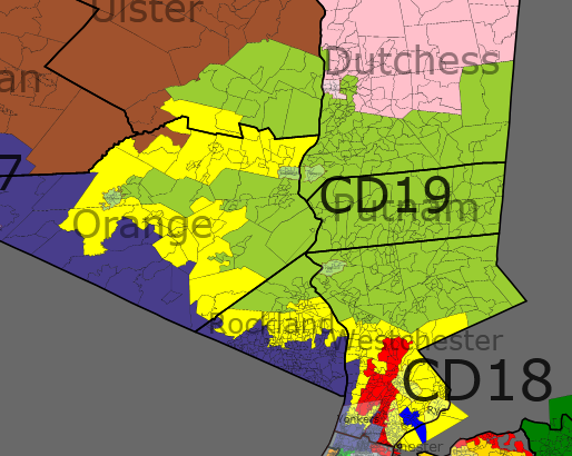
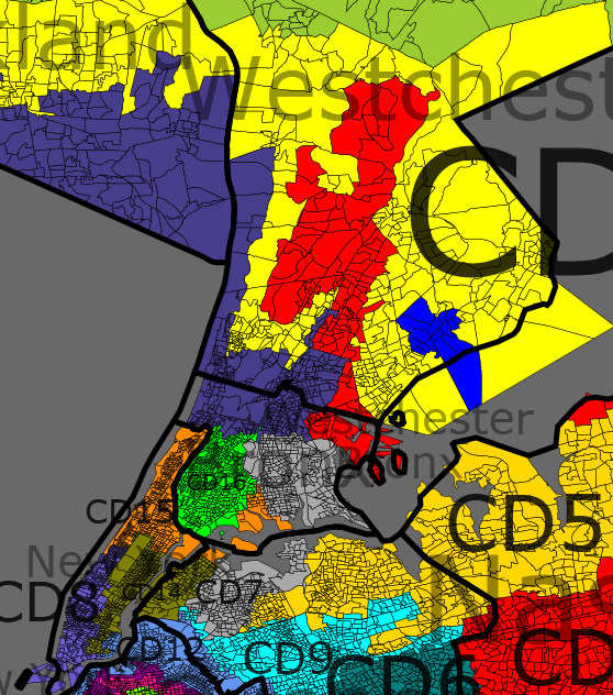
District 16: the successor to Eliot Engel’s current District 17. Based in his home neighborhood of Riverdale and including other portions of the northern Bronx as Engel’s current district does, but rather than only extending up the river to Rockland County, it takes in Republican areas of Rockland as well as a number of other Republican areas in the suburbs north of New York. In particular, it takes in Republican portions of Yonkers and Eastchester in Westchester County; Yorktown and much of Somers in northern Westchester; more than half of Putnam County; and East Fishkill and LaGrange in southern Duchess County. It is worth noting that the Metro-North New York commuter rail system extends even slightly beyond this district, to Poughkeepsie west of this district and Dover Plains and Wassaic to the east and northeast, so this is still essentially a district of New York City commuters.
Weakened to 60%-39% Obama-McCain from the current 72%-28% Obama-McCain, but Engel should be able to handle it– especially because I believe the heavily-Republican areas of Ramapo in Rockland that Engel is given here are Orthodox Jewish areas that may be won over by the fact that Engel is himself Jewish and has fairly hawkish/pro-Israel views on Middle East issues. 59% White, 22% Black, 14% Hispanic, 4% Asian, 2% Other. Total population 701,212.
District 17: the successor to Nita Lowey’s current District 18. Although it contains her hometown of Harrison and much of the rest of eastern Westchester, it extends through the eastern Bronx, across the Throgs Neck Bridge, and along the northern shore of Long Island to take in much of northeastern Suffolk County.
Weakened slightly to 60%-40% Obama-McCain from 62%-38% Obama-McCain for Lowey’s current District 18, but not enough to hurt Lowey, especially because the Long Island suburbs are a reasonably good fit for her current district. 66% White, 19% Hispanic, 9% Black, 4% Asian, 2% Other. Total population 700,635.
District 18: the successor to John Hall’s current District 19, but while it remains centered around his hometown of Dover, it extends largely up and down the Hudson Valley rather than across it. Some of Rockland, Orange and a little bit of Ulster County are included, but much of Westchester and portions of Columbia and Rensselaer counties are also included. On the southern end, in addition to Democratic portions of Yonkers and Mount Vernon, this district also includes a small piece of the northern Bronx.
Strengthened substantially, to 60%-40% Obama-McCain from the current 51%-48% in Hall’s current District 19, which should more than make up for the addition of unfamiliar areas. 72% White, 11% Black, 11% Hispanic, 4% Asian, 2% Other. Total population 700,716.
District 19: the successor to Scott Murphy’s current District 20 (which previously belonged to Kirsten Gillibrand), this remains fundamentally a northeastern Hudson Valley district, but is redrawn to add more Democratic areas. From Murphy’s hometown of Glens Falls in Warren County, it winds around (but avoids) Saratoga Springs and Schenectady, takes in the Democratic strongholds of Cohoes and Troy in the Albany area, and includes much of Washington, Rensselaer and Columbia counties. It also takes in Poughkeepsie and Beacon on the east side of the Hudson Valley, as well as Beacon’s sister city of Newburgh on the west side of the river, and continues down through western Putnam County to Peekskill and parts of Ossining and Cortlandt in northern Westchester.
Strengthened to 56%-43% Obama-McCain from the 51%-48% Obama-McCain of the current 20th District. 83% White, 7% Black, 6% Hispanic, 2% Asian, 1% Other. Total population 700,109.
District 20: the successor to Paul Tonko’s current District 21, this is centered around Albany and contains his hometown of Amsterdam just like the current district, and does include Rensselaer city on the east bank of the Hudson across from Albany, but rather than including Troy, Cohoes, and Schenectady (which have been reassigned elsewhere) extends through additional counties west of Albany, south to Ulster and even part of Sullivan county, and west to Delaware, Otsego, Herkimer and a little bit of Oneida.
Slightly weakened to 57%-41% Obama-McCain from the 58%-40% Obama-McCain of the current 21st District, but that shouldn’t be enough to cause any trouble for Tonko. 87% White, 6% Black, 4% Hispanic, 2% Asian, 1% Other. Total population 697,546.
District 21: the successor to Maurice Hinchey’s current District 22, this district still includes his hometown of Hurley and the west bank of the Hudson in Ulster County, and still extends west from there, but it has been substantially reshaped. It includes the northern suburbs of Binghamton, but no longer Binghamton itself; from there it extends north to include Republican areas of Cortland and Chenango counties and a little bit of Madison. It no longer includes Ithaca, home of Cornell University, but as compensation it extends through Rockland (where it takes in a number of Democratic areas) and down the bank of the Hudson to Morningside Heights in Manhattan and takes in Columbia University.
Slightly weakened to 57%-42% Obama-McCain from the 59%-39% Obama-McCain of the current District 22. Hinchey should be able to handle it, taking one for the team to help other Upstate Democrats. 74% White, 11% Hispanic, 9% Black, 3% Asian, 2% Other. Total population 699,827.
District 22: the successor to the current District 23, the Northern Tier district that Bill Owens won over Doug Hoffman. In addition to St. Lawrence County, Franklin, Clinton (including Owens’ hometown of Plattsburgh), and much of Essex, Jefferson, and Oswego, this district reaches south to take in the Democratic cities of Saratoga Springs and Schenectady.
Strengthened to 56%-43% Obama-McCain from the 52%-47% Obama-McCain of current District 23. 91% White, 4% Black, 3% Hispanic, 1% Asian, 1% Other. Total population 700,229.
District 23: the successor to Michael Arcuri’s current District 24. Includes Arcuri’s hometown of Utica, and nearby Rome, as well as Auburn and Cortland, and most of the part of Tompkins county currently represented by Arcuri. In addition, incorporates Binghamton and Ithaca itself (currently represented by Hinchey), and reaches down to take in some Democratic portions of Sullivan and Orange Counties (including Middletown), as well as a small piece of Rockland.
Strengthened to 56%-42% Obama-McCain (2% Other) from the 51%-48% Obama-McCain of current District 24. 86% White, 5% Black, 5% Hispanic, 3% Asian, 2% Other. Total population 700,163.
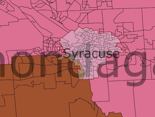
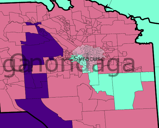
District 24: the successor to Dan Maffei’s current District 25. Still centered around Syracuse and including all of the surrounding Onondaga County, but reaches out east to the Oneida area and west to, among other areas, large portions of Ontario and Yates counties.
Same partisan breakdown as the current District 25: 56%-43% Obama-McCain. 88% White, 6% Black, 2% Hispanic, 1% Asian, 1% Native American, 1% Other. (In other racial breakdowns where the Native American percentage is displayed as 0%, I have not listed it separately. Total population 699,379.
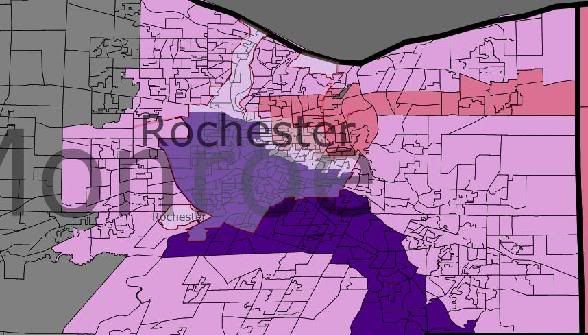
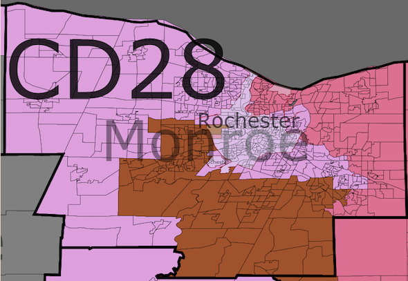
District 25: the successor to Louise Slaughter’s current district 28, or more precisely the successor to her old Rochester-based district before it got combined with Buffalo in the last redistricting. Contains Rochester and most of the surrounding Monroe County (including Slaughter’s home in Perinton), with the exception of some heavily Republican areas in the west of the county.
Only 59%-40% Obama-McCain, as compared to the 69-30% Obama-McCain of the current Rochester-to-Buffalo “dumbbell” district. But Louise Slaughter, and even her successor when she eventually retires, should be safe enough at 59%-40%. 77% White, 13% Black, 5% Hispanic, 3% Asian, 2% Other. Total population 700,707.
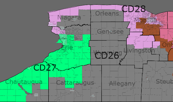
District 26: successor to the current District 26, this is the designated Republican district, home to Christopher Lee. (At least, it likely includes his Clarence home; a small portion of Clarence is not included, but the boundaries can be tweaked if necessary.) Ranging from Republican suburbs and rural areas south and east of Buffalo to other Republican rural areas of the state, such as Steuben County in the Southern Tier and much of Hamilton County in the Northern Tier, all the way east to Essex County near the Vermont border.
39%-59% Obama-McCain, as compared to the 46%-52% Obama-McCain currently. 95% White, 2% Black, 2% Hispanic, 1% Other. Total population 701,016.
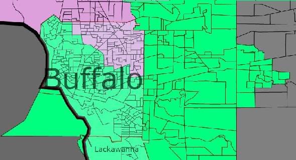
District 27: successor to Eric Massa’s current District 29. Runs from his Corning hometown along the southern New York State border to take in Democratic areas like Elmira city and Salamanca city, and Jamestown city in Chautauqua county, and then extends up to northern Buffalo and the northeastern Democratic suburbs of Buffalo. Also extends a tentacle up from the Southern Tier to take in the town of Geneseo in Livingston County (more than 10,000 voters split 63%-35% Obama-McCain, due in substantial part to the 5,000-student State University of New York Geneseo campus).
Strengthened to 56%-42% Obama-McCain from the 48%-51% Obama-McCain of Massa’s current District 29. 84% White, 11% Black, 2% Hispanic, 2% Asian, 1% Other. Total population 701,136.
District 28: the successor to Brian Higgins’ current District 27. Still includes southern Buffalo, much of southern Erie County and much of Chautauqua county, but omits Republican portions of Erie and Chautauqua, and also passes through western Buffalo to Niagara Falls, Tonawanda, North Tonawanda, and Lockport in Niagara County.
Strengthened to 56%-43% Obama-McCain, as compared to the 54%-44% Obama-McCain of the current District 27. 85% White, 8% Black, 4% Hispanic, 1% Asian, 1% Native American, 1% Other. Total population 700,553.
