A Regional Party Limited to the South: The Democrats in the 1920s, Part 2

This is the second part of three posts analyzing the Democratic Party’s struggles  during the 1920s, when it lost three consecutive presidential elections  by landslide margins. This will focus upon the 1920 and 1924 presidential election, when white ethnic immigrants abandoned the Democratic Party.

The last part can be found here.

The 1920 Presidential Election

Part 2

The Democratic Party of the early twentieth century was composed of  two bases (both of which no longer vote Democratic). These were Southern  whites and immigrant, often Catholic, whites from places such as  Ireland and Italy. Southern whites voted Democratic due to the memory of  the Civil War and could be reliably whipped up with race-baiting  appeals. Immigrant ethnic whites, on the other hand, saw the Democratic  Party as a vehicle of defense against the dominant, Republican-voting  WASP majority in the Northeast and Midwest.

The two groups had precious little in common, save distrust of the  dominant Republican Party. One of the constituencies would often  only lukewarmly support the national Democratic candidate (this was  usually the immigrant  camp, because without Southern whites the  Democratic Party was nothing).

In 1920, ethnic whites walked out of the Democratic Party.

More below.

The city  machines at Tammany Hall and others did not just fail to fully back  Democratic candidate James M. Cox; they outright refused to support him.

This was entirely the fault of Democratic President Woodrow Wilson. The previous year, Mr. Wilson had delicately stated that:

…there is an organized propaganda against the League of  Nations and against the treaty proceeding from exactly the same sources  that the organized propaganda proceeded from which threatened this  country here and there with disloyalty, and I want to say — I cannot  say too often — any man who carries a hyphen about with him carries a  dagger that he is ready to plunge into the vitals of this Republic  whenever he gets ready.

If I can catch any man with a hyphen in this great contest I will know that I have got an enemy of the Republic.

The political stupidity of this quote cannot be overstated. The “man  with a hyphen” was not just a politically influential constituency; in  states like New York, Massachusetts, and Wisconsin he was the Democratic Party.

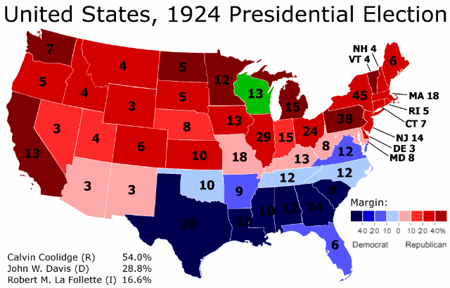
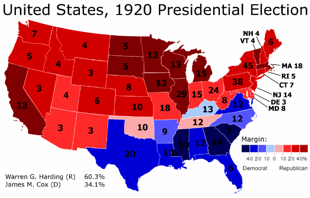
This, along with Mr. Wilson making the 1920 election a referendum on his extremely unpopular League of Nations, led to the result in the map above.

Democratic candidate James M. Cox lost everywhere outside the Solid South. He got barely one-fourth of the vote in New York City, less than one-fourth in Chicago, less than one-fifth in Detroit, and so on throughout all the great non-Southern cities. In the “hyphen-heavy” states of Wisconsin, the Dakotas, and Minnesota, Mr. Cox failed to break the 20% mark. Even in the Solid South, Republicans broke 30% of the vote – for the first time since 1908, when disenfranchisement of blacks was complete.

All in all, Democratic candidate James M. Cox lost by 26.2% – the greatest defeat in the popular vote, ever.

The 1924 Presidential Election

Part 2

In 1924, the Democratic Party nominated a man with the distinction of being more conservative than the Republican.

Little known John W. Davis was not just a social conservative who endorsed segregation – that was true for all Southern Democrats at the time – but also an economic conservative. Mr. Davis believed in small government, states rights, and would go on to oppose President Franklin Delano Roosevelt’s New Deal.

Mr. Davis was nominated as a compromise candidate after one of the longest and nastiest Democratic conventions in history – a bitter fight with immigrant whites from big cities against Southern and Western rural whites. By the time the convention had ended, it was clear that Democrats didn’t stand a chance of winning the 1924 presidential election. After Mr. Davis’s nomination, ethnic whites walked out once again.

In 1924, Democrats lost big again. They lost by more than Walter Mondale against Ronald Reagan. They lost by more than Herbert Hoover against FDR. All in all, the Democratic candidate lost by the second greatest popular margin in American history, right after 1920.

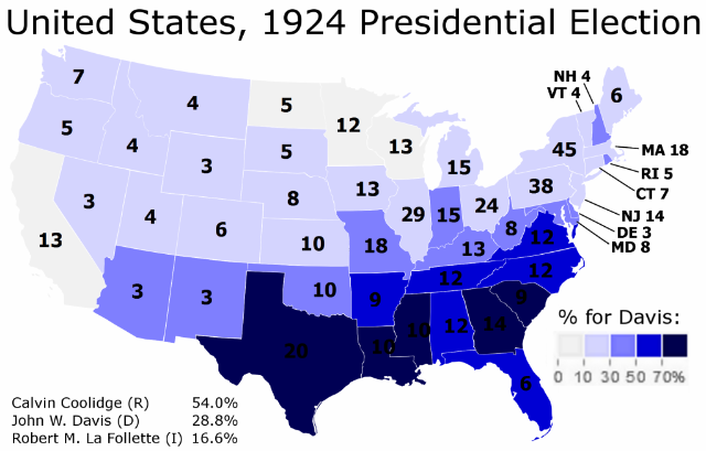
Mr. Davis won between one-fourth and one-third of the votes. Southern whites stayed loyal; indeed, he did a quite bit better than Mr. Cox in 1920 in the Solid South.

White ethnics did not. In 1920 white immigrants had sat out the election. This time they voted for Governor Senator Robert La Follette, who was the only liberal candidate in the race. Mr. La Follette did better than the Democratic candidate in a dozen states.

Everybody else voted for Republican candidate Calvin Coolidge. Mr. Davis lost almost every single non-Southern city, including all five boroughs of New York (the last time a Democratic presidential candidate would lose New York). In Detroit, Milwaukee, Minneapolis, Los Angeles, Philadelphia, and San Francisco the Democratic candidate got less than 10% of the vote.

All in all, Mr. Davis failed to break 30% in more than half the states:

Part 2

In the aftermath of this election – a second disastrous election in a row for Democrats – it was clear that a change in strategy was needed. For two elections in a row, Democrats had won Southern whites and nobody else.

In 1928, therefore, the Democratic Party nominated the candidate of the white ethnics to run for president. This time it was the turn of the Southern whites to walk out.

–Inoljt, http://mypolitikal.com/
A Regional Party Limited to the South: The Democrats in the 1920s, Part 1

This is the first part of three posts analyzing the Democratic Party’s struggles during the 1920s, when it lost three consecutive presidential elections by landslide margins.

The second part can be found here.

A Regional Party Limited to the South

The biggest presidential landslides are two elections you’ve probably never heard of: the 1920  presidential election, and the 1924 presidential election.

More below.

In the 1920 presidential election, Democratic candidate James M. Cox lost by 26.2% to Republican candidate Warren G. Harding. Four years later, Democratic candidate John Davis would get barely more than one-fourth the vote in another landslide defeat. These two elections constitute the biggest victories in the popular vote in the history of American presidential elections.

In the aftermath of President Barack Obama’s victory, Democratic strategists liked to boast that the Republican Party was becoming a regional party restricted to the South. This meme has become less popular in light of Republican gains during the 2010 mid-terms, in which Republicans did quite outside the South (especially in the Midwest).

Yet during the 1920s, the Democratic Party really was a regional, Southern-based party that had great difficulty competing outside the South. It was a party that was completely unrecognizable today: a proudly racist, white supremacist organization in which its two main constituencies refused to back the same candidate not for one, not for two, but for three consecutive elections.

The story begins with World War I and President Woodrow Wilson.

— Inoljt, http://mypolitikal.com/

Analyzing Swing States: Colorado, Conclusions

This is the last part of a series of posts analyzing the swing state Colorado.

Conclusions

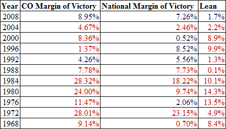
Colorado is much like the previous state analyzed in this series: Virginia. Both states were seen until recently as Republican strongholds and rightfully so; President George W. Bush handily won both states in 2004 and 2000.

Yet in 2004, both states showed signs of shifting Democratic. Virginia barely moved Democratic even as the South swung heavily against Senator John Kerry. As for Colorado – it actually shifted 3.7% more Democratic, against the national tide. Indeed, in 2004 Mr. Kerry performed better in Colorado than he did in Florida.

More below.

This shift cumulated in the 2008 presidential election, which showed both Colorado and Virginia as influential swing states. Colorado has thus turned from a red state into a purple state. In doing so, the Democratic Party has carved out the following coalition:

Analyzing Swing States: Colorado,Conclusions

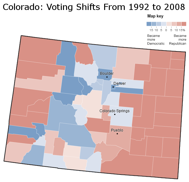
Democratic gains since 1992 follow the “C” pattern that was also present in the actual 2008 county results. This is a pattern that is present in other parts of the country, as previous posts have observed. Democrats have generally improved along the Front Range, and especially in the Denver metropolis. They have also gained in two Republican strongholds: Colorado Springs and neighboring Douglas County.

On the other hand, Republicans have gained in several historically Democratic-voting Hispanic counties near Pueblo. They have also improved in the thinly populated rural stretches of east and west Colorado.

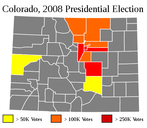
All in all, these changes have benefited Democrats more. This is because their gains have been in the more populated areas of Colorado:

Analyzing Swing States: Colorado,Conclusions

The heart of Colorado is therefore in the Denver metropolis, as the map indicates. Since 1992 Democrats have improved in all but one of the orange and red counties. In 2000 Mr. Bush won seven of the eleven highlighted counties. In 2008 Mr. Obama won seven of them. This is responsible for Colorado’s 17.3% leftward shift from 2000 to 2008.

This leftward shift has not turned Colorado into a blue state, but rather into a vitally important swing state. Say, for instance, that Mr. Obama had tied Senator John McCain in the popular vote. North Carolina and Indiana would have immediately flipped Republican. This would be followed by the traditional swing states Florida and then Ohio. Virginia would flip Republican next; Mr. Obama would lose by less than a percent. At this point Mr. McCain would have 262 electoral votes.

And there he would remain. In a tied election, Colorado would go by 1.7% to Mr. Obama, handing the senator 278 electoral votes and the presidency.

In the 2008 presidential election, therefore, Colorado was the most important state to win. It may remain thus in 2012.

–Inoljt, http://mypolitikal.com/
Analyzing Swing States: Colorado, Part 4

This is the fourth part of a series of posts analyzing the swing state  Colorado. It will focus on the complex territory that constitutes the Democratic base in Colorado. The last part can be found here.

Democratic Colorado

In American politics, the Democratic base is almost always more complex than the Republican base, a fact which is largely due to complex historical factors. Democrats wield a large and heterogeneous coalition – one which often splinters based on one difference or another. The Republican base is more cohesive.

The same is true for Colorado. Republican Colorado generally consists of rural white Colorado and parts of suburban white Colorado. Democratic Colorado is more difficult to characterize.

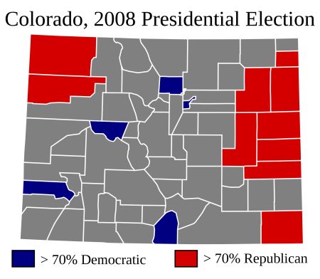
A look into President Barack Obama’s strongest counties provides some insight:

Photobucket

More below.

The Republican counties pictured here are fairly similar: they are thinly populated, homogeneously white rural counties. The Democratic counties, on the other hand, are quite different. There are four facets to Colorado’s Democratic base, and each facet is represented in the picture above.

Denver and Boulder

As the post focusing on the Republican base explained, the red-colored counties above constituted 1.2% of the total vote in 2008. A Republican who wins Colorado will win these places, but they are not necessary to win the state.

The same is not true for a Democrat who wins Colorado. The blue-colored counties – or, more specifically, Denver and Boulder – are absolutely essential for a Democratic candidate to win Colorado.

The map below illustrates this fact:

Analyzing Swing States: Colorado,Part 4

As is evident by the map, Denver County and Boulder County are the two foundations of the Democratic base in Colorado. Mr. Obama gained a margin of 221,570 votes from the two counties. Without the cities of Boulder and Denver, Mr. Obama would have lost Colorado – by around 6,500 votes.

Cities are the mainstay of the Democratic Party in modern-day America, and so it is unsurprising that the Democratic base in Colorado rests upon two cities. Yet not all Democratic cities are alike. Boulder and Denver represent two dramatically different types of cities, both of which vote Democratic.

Boulder is a stronghold of Democratic liberalism; in 2000 it gave Green Party candidate Ralph Nader 11.8% of its vote. Like most liberal places in America (San Francisco, Portland, Seattle, the state of Massachusetts) the median resident of Boulder is richer than the median resident of the United States. Boulder is also more homogeneous than the United States; whites compose something like four out of five people in Boulder County. In this, Boulder is also not much different from most liberal places either.

Denver, in contrast, has more in common with machine-cities like Chicago, Los Angeles, and Detroit. Like these cities, Denver is poorer than the United States. Another commonality is the high number of minorities: Hispanics are more than one-third the total population, non-Hispanic whites less than half. Places like San Francisco and Seattle are more Democratic than liberal; places like Denver are the opposite. On the other hand, in 2000 Mr. Nader also got 5.86% of Denver’s vote – indicating the presence of a substantial liberal bloc.

Electorally, however, these differences do not matter. Both Denver and Boulder vote consistently and powerfully Democratic, and will continue doing so in the foreseeable future.

Rural Democratic Colorado

Colorado and Denver, however, constituted only two of the five blue-colored counties in the first map. The other three are rural, thinly populated, and highly Democratic areas. This may sound strange at first, given the extent of Democratic weakness in rural America. Yet the Democratic parts of rural Colorado have either one of two characteristics.

The first characteristic is indicated by the picture below:

Analyzing Swing States: Colorado,Part 4

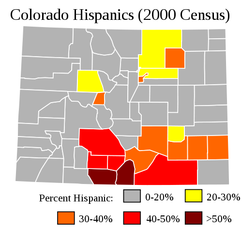
This map uses 2000 Census data to provide a picture of Colorado’s Hispanic population. In 2000 Latinos constituted 17.1% of Colorado; today their numbers have risen to 19.9% of the state population.

Latinos tend to be concentrated in two places: Denver and the areas to its northeast, and a broad band stretching from south-central to south-east Colorado. The latter areas tend to be rural, thinly populated, and the poorest places in Colorado. Due to the high numbers of Latinos, most of these counties usually vote Democratic.

But not all of them. Latinos are not as reliably Democratic as blacks, and they also turn-out in lower numbers. Thus counties with high Latino population correlate with but do not ensure Democratic victory. In 2008, Senator John McCain won seven of the eighteen counties with greater than 20% Latino population. In 2000 Governor George W. Bush actually won Conejos County, where about 58.9% of the population is Latino. Out of the rural counties above, Democrats are only guaranteed victory in the south-central band.

Ski resorts function as another characteristic of rural Democratic Colorado:

Analyzing Swing States: Colorado,Part 4

For whatever reason, rural counties dominated by ski resorts vote strongly Democratic. These counties are largely located along Colorado’s Front Range. In two of them Mr. Obama won over 70% of the vote: Pitkin County and San Miguel County. Both are home to famous ski resorts: Aspen Mountain in the former and Telluride Ski Resort in the latter.

Ski resort counties are strange places for Democrats to do well in. They are the opposite of the poor Latino counties which also vote Democratic. The people who live in them are generally quite rich, quite famous, and quite white. Rich, 90% non-Hispanic white San Miguel County does not sound at first glance like a Democratic stronghold. Yet when described this way, San Miguel County looks a lot like another Democratic place: Massachusetts.

Conclusion

The counties that form the Democratic base form the shape of a “C.” A strong Democratic candidate will expand and fatten the “C.” A strong Republican candidate will cut into the “C” and often split it in two.

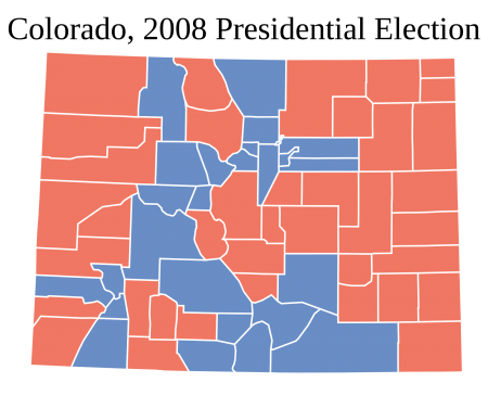
President Barack Obama’s 9.0% victory in Colorado provides one illustration of this Democratic “C”:

Photobucket

In this “C,” all four elements of the Democratic base in Colorado are present. Denver and Boulder form the top part of the “C, which is augmented by suburban Denver counties which Mr. Obama also won. The rural ski resort counties on the Front Range form the left side of the “C,” and the rural Latino counties compose the bottom part.

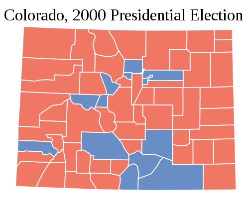
President George W. Bush’s 8.4% victory in 2000, on the other hand, provides an instance of a Republican breaking the Democratic “C”:

Analyzing Swing States: Colorado,Part 4

Mr. Bush makes inroads everywhere: both rural ski resort counties, rural Latino counties, and the Denver-Boulder metropolis are much more Republican. The Democratic “C” is just present, but barely so.

Unlike other states, therefore, it is relatively easy to tell whether the state is voting for a Democrat or Republican just by looking at a county map. A Democratic victory will look like Mr. Obama’s map. A Republican victory will look like Mr. Bush’s map. This is unlike a state such as New York or Illinois, where Democrats or Republicans can win a 5% victory under the same county map.

(Note: Some maps are edited NYT images.)

–Inoljt, http://mypolitikal.com/
Analyzing Swing States: Colorado, Part 3

This is the third part of a series of posts analyzing the swing state  Colorado. It will focus on the swing areas in Colorado – the parts that will vote for both Democrats and Republicans. The fourth part can be found here.

Swing Colorado

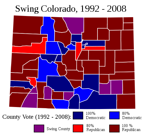
The swing areas of Colorado lie on the edges of the Democratic base in Colorado, which forms a rough “C” shape (more on this in the next post). They can be mapped as below:

Analyzing Swing States: Colorado,Part 3

More below.

This map incorporates five presidential elections, from 1992 to 2008. Republicans won the state three times; Democrats twice. Of the swing counties pictured here, President Bill Clinton did better in the rural swing areas, mostly in southern Colorado. President Barack Obama, on the other hand, had his strength in several highly populated, suburban swing counties.

Swing Colorado is, like the Republican base, divided into two quite different domains. The first domain is composed by the rural, “Clinton” counties. This region has much in common with the Republican parts of rural Colorado; it is generally poorer and extremely thinly populated.

The difference lies with two things: Hispanics and ski resorts. Areas of rural Colorado with high numbers of Hispanics and ski resorts vote solidly Democratic; areas with low numbers vote solidly Republican. Swing counties generally have enough Hispanics or ski resorts to be competitive for Democrats, but not enough to automatically vote Democratic.

Interestingly, the rural swing counties with ski resorts have become more Democratic over the years, while the rural swing counties with Hispanics have become less so. Mr. Obama generally did worse in rural Hispanic Colorado than Mr. Clinton. Whether because the Hispanic population is locally in decline in this thinly populated area, or because Hispanics are voting more Republican, is uncertain.

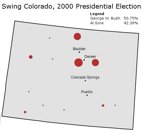
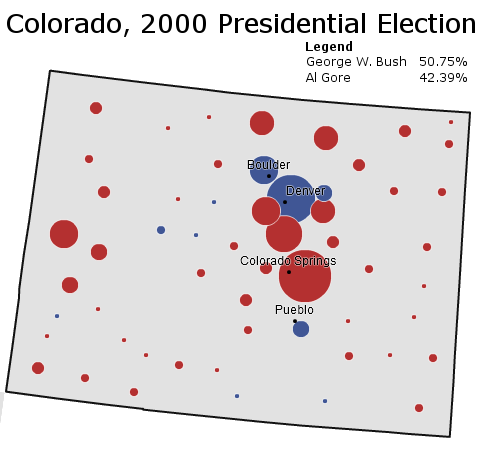
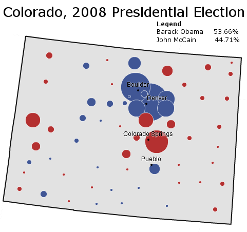
The second part of swing Colorado consists of a set of three suburban counties  surrounding the Denver metropolis. These counties used to vote solidly Republican, which was why Colorado was Republican for so long. Here is how they voted in the 2000 presidential election:

Analyzing Swing States: Colorado,Part 3

The counties – Arapahoe County, Jefferson County, and Larimar County – are pictured by the three large red circles around Denver and Boulder. As is apparent, their importance is of a magnitude above that of the rural swing counties. Indeed, in 2008 the three counties composed 30.8% of the votes cast in Colorado. Jefferson County had more votes cast than any other county in the entire state.

Winning these suburbs, therefore, is naturally important. Until recently they generally leaned Republican. As swing areas, Republicans usually didn’t win them by landslides; they generally had a ceiling of around 65% of the vote. But they won them, and therefore they won Colorado.

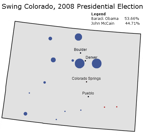
It is the shift in places like these that is responsible for recent Democratic gains in Colorado. Here is how swing Colorado voted in 2008:

Analyzing Swing States: Colorado,Part 3

Mr. Obama won Arapahoe County, Jefferson County, and Larimer County by 12.91%, 8.91%, and 9.73% respectively. Combined, he came out with a 77,067 vote margin out of swing Colorado. This was enough to erase the Senator John McCain’s margins in his two strongest counties – El Paso (Colorado Springs) and Douglas Counties. Mr. Obama also did this out of historically Republican territory.

Demographically, the three counties above share certain similarities. For suburbs, they are actually not that rich; median household income is only slightly above the national average (Jefferson County is richest). The counties are also fairly homogeneous; approximately four out of five residents in Jefferson and Larimer County are white and non-Hispanic. Arapahoe County, on the other hand, is more diverse; non-Hispanic whites compose about 65% of the population (a mirror of the country, in fact). Unsurprisingly, Mr. Obama did best in Arapahoe County.

To be fair, Mr. Obama’s performance in Colorado’s formerly Republican-leaning suburbs probably constitutes something of a ceiling for Democrats. Mr. Obama did extremely well in exurbs like these throughout the nation, in both the primaries and the general election. The housing crisis did not hurt things, either. A different Democrat might rely less on these suburbs.

Nevertheless, the very fact that a Democrat can now win places like Larimer County is something of an achievement for the party. Indeed, almost all of swing Colorado constitutes formerly Republican-leaning territory that Democrats have made competitive over the past two decades. Democrats have also carved out a new and many-sided base in Colorado during this time period. The next post will examine the complex elements that make up Colorado’s Democratic base. will examine the complex elements that make up Colorado’s Democratic base.

–Inoljt, http://mypolitikal.com/
New York’s Republican Primary and New York Politics, Part 2

This is the second part of two posts analyzing New York’s recent Republican primary. It will focus upon Republican weakness in New York City, as revealed by the primary. The previous part can be found here.

New York City in the Republican Primary

One of the more interesting things about American politics is the rural-urban divide. The weakness of the modern Republican Party in urban areas is quite astounding. Much of this has to do with the history of the American city, especially the way in which many cities have become reservoirs of poor minorities.

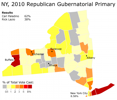
The Republican gubernatorial primary constituted a particularly powerful demonstration of Republican weakness in American cities. To illustrate this, let’s look at a map of turn-out in businessman Carl Paladino’s victory over former representative Rick Lazio:

Part 2

More below.

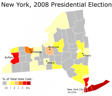
This map shows the vote cast by each county as a percentage of the total vote cast in the primary. Erie County, for instance, cast 46,054 votes in the primary. Since 442,608 people voted in total, the county cast 10.41% of the total primary vote.

The turn-out map reveals some fascinating patterns. The biggest counties in the Republican primary were in Buffalo and Long Island. High number of Republicans also voted in Rochester, Syracuse, and Westchester County (north of New York City).

On the other hand, New York City participation in the Republican gubernatorial primary was dismal. Fewer people voted in the five boroughs combined than in Erie County (Buffalo). More than twice as many people voted in all Long Island than in New York City. In the Bronx, 2358 people decided to participate in the Republican primary. This is in a place where an estimated 1,382,793 people live.

Compare these figures to 2008 presidential election:

Part 2

Here we see New York City punching at something closer to its actual strength. Like a giant magnet, New York City’s population pulls away influence from upstate New York and directs it to itself. Indeed, in the presidential election New York City is four times as important as it was in the 2010 gubernatorial Republican primary – constituting 34.23% of the total vote, compared to 8.58% in the Republican primary.

This really says something about the state of the Republican Party in New York City.


New York City in the General Election

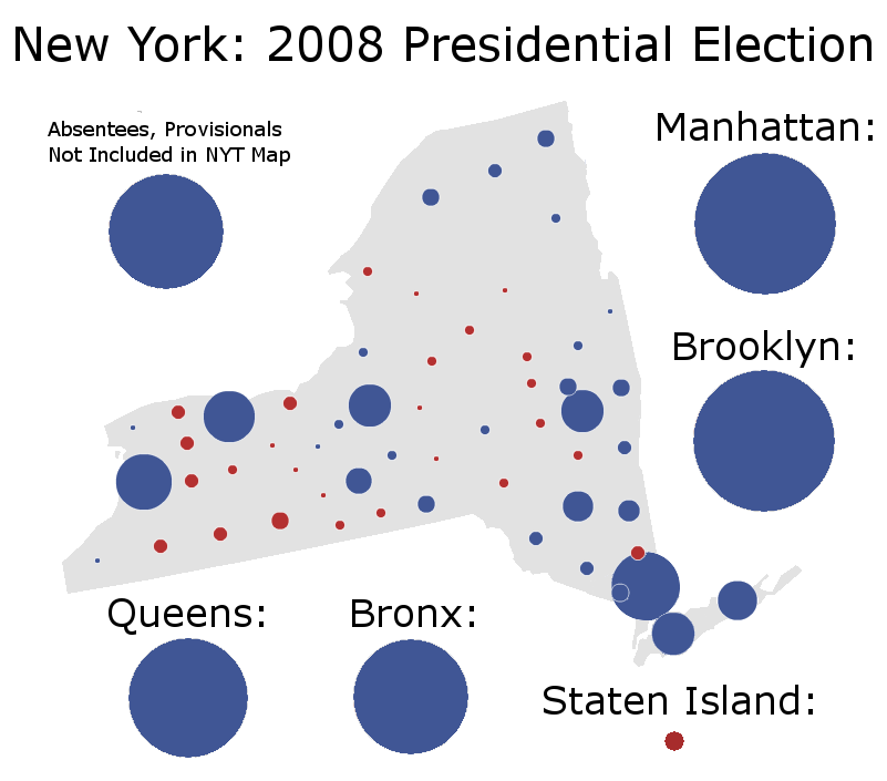
The above two maps do not really hammer in the importance of New York City. Stating that five boroughs hold one-third of a state’s vote is one thing, but actually seeing it is another.

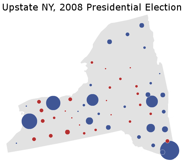
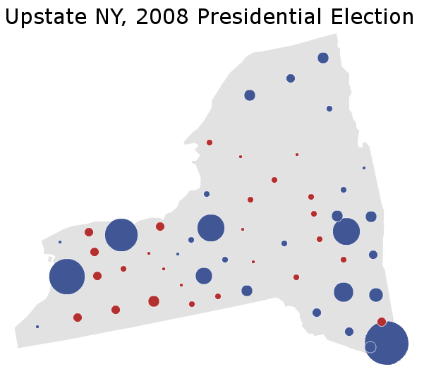
The previous post contained an image of New York in the 2008 presidential election. This map only reflected President Barack Obama’s performance in upstate New York, which he won by the high single digits. Here is a picture of said map:

Part 2

(Note: Edited NYT Image. This map underestimates Mr. Obama’s strength, since it doesn’t include a number of absentee ballots and provisional ballots. Both, especially the absentees, tended to go more Democratic than the national average in 2008.)

This looks good for Mr. Obama. There is a lot of blue here and not a lot of red. In reality, however, most of the territory mapped above actually does not belong to the Democratic base. In a close election, almost all of these counties would go strongly Republican. These are the places that generally voted for Carl Paladino.

The real area of Democratic power is in New York City. Let’s add New York City to the above map:

Part 2

Mr. Obama looks really good here; indeed, the blue margins are so large that it is hard to comprehend their magnitude.


Concluding Thoughts

All in all, the divide between New York City’s importance in the Republican primaries and its importance in the general election is quite amazing. It really points to what the Republican coalition of voters is like today. Cities are almost an afterthought; most Republicans assume they will vote Democratic anyways, and so they don’t even bother to compete.

In some states this can be a wise concession. In most states taking the suburbs and the rural areas – occasionally, winning just the rural areas – is enough to win a state election. Cities are not always necessary to win. On the other hand, they certainly are useful to win elections, especially in a state like New York.

Republican candidate Carl Paladino does not look like he will win the general election. Originally trailing Democratic Attorney General Andrew Cuomo 2-to-1, the Republican national wave has closed this to a high single-digit gap. This, however, will be hard to surmount – for much of the remaining gap lies in winning New York City voters, almost none of whom participated in the primary electorate which chose Mr. Paladino.

New York’s Republican Primary and New York Politics, Part 1

This is the first part of two posts analyzing New York’s recent Republican primary. It will focus upon the upstate-downstate divide revealed by the primary. The next part can be found here.

The 2010 Republican Gubernatorial Primary

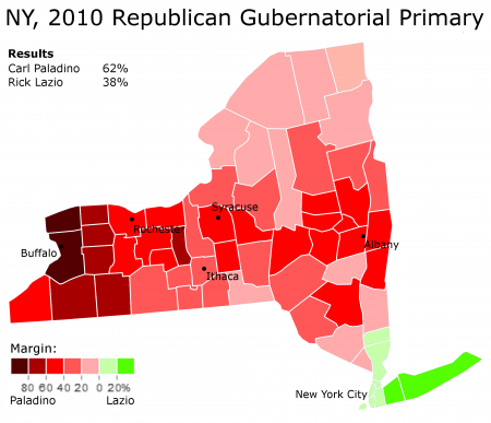
On September 14th 2010 the Republican Party held its primary in New York. In the gubernatorial primary, party favorite Rick Lazio was defeated by the Tea Party Candidate: businessman Carl Paladino. Mr. Paladino won a comprehensive victory, with 62% of the vote to Mr. Lazio’s 38%.

In the long run, this primary does not matter much – if at all. By next month the primary will all but be forgotten by even the most politically intense folk. Most Americans probably weren’t even aware that there was a primary in the first place.

Yet, whatever its long-term importance, the primary constitutes a valuable tool for exploring New York’s electoral geography. Mr. Paladino’s victory revealed two interesting facts of New York politics. This post will explore the first one.

The Upstate-Downstate Divide

Picture the state of New York, and most Americans will think of a certain city. This fact has long frustrated the many folks who live in upstate New York – which contains more than seven or eight million people, depending on how one defines upstate.

New York state politics have thus been dominated by the divide between upstate and downstate. Upstate generally votes Republican on a local level; downstate votes heavily Democratic. The divide is also apparent in the battle over whether resources are to be spent upstate or in New York City.

On the presidential level, this pattern is relatively hard to discern:

Part 1

A look at upstate New York in the 2008 presidential election shows President Barack Obama dominating. While downstate New York casts an extremely Democratic ballot,  upstate New York also votes for the blue side.

Indeed, Democrats have actually won upstate New York for the past five elections. This table indicates how New York has voted in several recent elections:

Part 1

Only in 1988 does Governor Mike Dukakis lose the upstate vote, and even then Mr. Dukakis does fairly respectably. (Note: This table includes suburban Westchester and Rockland County as part of upstate; an alternative definition may not do so). Thus, it is somewhat difficult to find a difference between upstate and downstate New York when looking at presidential elections.

This was not the case with New York’s Republican gubernatorial primary. Here is a map of the results:

Part 1

This is a tremendous regional divide. Upstate New York votes overwhelmingly for Mr. Paladino, while downstate gives Mr. Lazio a strong vote, despite his overall poor performance. Indeed, in Erie County (Buffalo) Mr. Paladino actually got 93% of the vote. On the other hand, Long Island Suffolk County gave his opponent two-thirds of its support.

Not surprisingly, Mr. Paladino’s home is located in Buffalo, while Mr. Lazio represented a congressional district in central Long Island. Mr. Lazio was also born in Suffolk County. His long history with downstate New York led to considerable discontent upstate, and constituted one factor behind its landslide rejection of Mr. Lazio.

There is one final thing that must be noted, however. While Mr. Paladino definitely looks like a winner under the map above, the 3:2 split may look strange to seasoned observers of New York politics. Mr. Lazio, after all, is winning both New York City and its suburbs. Manhattan, Brooklyn, and Queens are supporting him by double-digits – while he is running very strongly in Long Island.

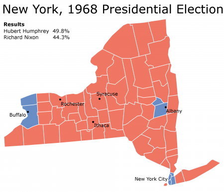
Democrats have won New York with similar maps. Here is one such map:

Part 1

As it turns out, Mr. Lazio would have indeed done a bit better under general election circumstances. That is, if Mr. Lazio had won the same percent of the vote in each county in the 2008 presidential election, he would have gained 40% of the vote. This is not an enormous change, but in a close election it means the difference between victory and defeat.

This seeming contradiction lies at the heart of another interesting truth that New York’s Republican primary revealed: namely, that Republicans do not exist in New York City. The next post will explore this strange phenomenon.

Analyzing Swing States: Colorado, Part 2

This is the second part of a series of posts analyzing the swing state Colorado. It will focus on the Republican base in Colorado. The third part can be found here.

Photobucket

History

Once upon a time, Colorado was a loyally Democratic state. Influenced by prairie populism and anger against powerful Republican businessmen in the East Coast, the state usually voted further left than the country at large. The trend continued for seven straight presidential elections.

More below.

This ended at around 1924. Colorado voted twice against President Franklin Delano Roosevelt, and throughout the remainder of the twentieth century remained a mainstay of Rocky Mountain conservatism. As late as 2005, a Republican politician might have good reason to see this as a permanent condition.

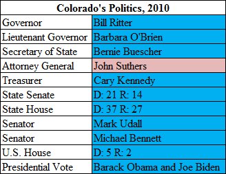
Said politician would have been shocked to see Colorado three years later, after a massive Democratic wave. In 2008, the state voted more Democratic than the national average for the first time in ten presidential elections. And as of September 2010, Attorney General John Suthers is the only statewide Republican officeholder.

Republican Colorado

For a long time, the Republican base in Colorado really was the entire state, minus Denver and a few thinly populated Hispanic counties in the south. Almost all of Colorado voted Republican; there was little that hinted it would ever be more than a solidly Republican state.

That this has changed is fairly obvious; it is why Colorado is now a swing state. The modern Republican base in Colorado consists of two entities. To get a look at the first, let’s take a look at the counties which gave Senator John McCain his strongest support.

Photobucket

The counties highlighted in red are quite representative of the first part of the Republican base: rural Colorado. This description must be qualified a bit further, since some parts of rural Colorado vote fairly Democratic. The first part of Republican Colorado actually constitutes white rural Colorado, minus those parts whose main industry consists of skiing resorts (Hispanic rural Colorado is fairly Democratic, as are the parts of rural Colorado home to massive skiing resorts).

This region has quite a lot in common with other Republican-voting rural counties in the Great Plains and Mountain West. The people are generally white and poorer than the national median. They have been also voting Republican ever since the days of President Woodrow Wilson. Democrats often bemoan the loss of poor whites in places like West Virginia who once voted faithfully Democratic. But in much of rural Colorado, the white working class was never Democratic in the first place.

There is one last distinguishing characteristic of this region: it is extremely thinly populated. Indeed, in 2008 a total of 28,159 votes were cast in the highlighted counties above – about 1.2% of Colorado’s total electorate.

Thus, Republican strength in rural Colorado is a secondary force the Republican coalition:

Photobucket

(Note: Edited NYT Image.)

The second wing of Colorado’s Republican base is different. As the above map indicates, it can be seen in the Republican margins in the counties radiating around Denver, and especially in Colorado Springs.

These suburbs and exurbs constitute the second part of the Republican base in Colorado. Like most suburbs, they are generally wealthy, well-off places. Another distinguishing factor of Republican-leaning suburbs is their ethnicity: the reddest Republican suburbs tend to be the whitest.

Colorado Springs provides of typical example what makes a Republican suburb in Colorado. The largest red circle in the map, the city is famous as being the headquarters of a number of evangelical groups (such as James Dobson’s Focus on the Family). It also contains a substantial military population, which generally votes Republican.

The map above provides an example of Republican Colorado at a strong point. In 2000 neither party competed for Colorado, and the state went predictably and strongly Republican – as it had for decades beforehand. Republican strength in rural and suburban Colorado more than overwhelmed the Democratic-voting areas.

The next post will examine how much of Republican-voting suburban Colorado turned into swing territory.

–Inoljt, http://mypolitikal.com/
Analyzing Swing States: Colorado, Part 1

This is the first part of a series of posts analyzing the swing state Colorado. The second part can be found here.

Analyzing Swing States: Colorado,Part 1

Starting six years ago, a massive Democratic wave swept through the state of Colorado. Starting with the election of former Senator Ken Salazar, the Democratic Party took control of almost every state office there was to take. The results of this transformation are pictured in the table above.

More below.

At the time, Democrats crowed that Colorado was undergoing a fundamental political transformation. A flood of liberal migrants from California, along with steady growth in Colorado’s Latino population, was supposedly moving the state left from its decades-old conservative roots.

These conservative roots can be seen by taking a look at Colorado’s electoral history:

Analyzing Swing States: Colorado,Part 1

Six years later, however, Democrats are not so confident. Polls show that Colorado has swung as quickly Republican as it went Democratic after 2004. Democrats are facing tough elections in Colorado’s senatorial and house races; until the Republican candidate became engulfed in scandal, they were also polling weakly in the gubernatorial race.

Whatever the future of Colorado, for the past decade the state has done a perfect job of reflecting the national mood. This is perhaps the ultimate attribute of a swing state.

–Inoljt, http://mypolitikal.com/
Analyzing Polish Elections

By: Inoljt, http://mypolitikal.com/
The country Poland is comprised of two main political parties; the first is Prawo i Sprawiedliwosc  (PiS) – “Law and Justice” in English. This party is a populist group which runs upon anti-corruption and anti-Communist credentials. The second party is the Platforma Obywatelska (PO) – in English the “Civic Platform” – a group espousing support for free market capitalism.

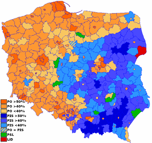
On October 2007, Poland held parliamentary elections between the two parties. Most of the Western media backed the Civic Platform (PO), disliking the unpredictability of the Kaczynski twins (leaders of Law and Justice). Here is a map of the results:

Photobucket

More below.

As it turns out, the Civic Platform (PO) won the election, taking 41.5% of the vote. Law and Justice polled 32.1%, with the rest of the vote going to third parties.

A clear regional split is apparent in these results. Poland’s southeast – with the exception of Warsaw – generally voted for Law and Justice (PiS). On the other hand, support for the Civic Platform (PO) took a sickle-like shape along Poland’s northern and western borders.

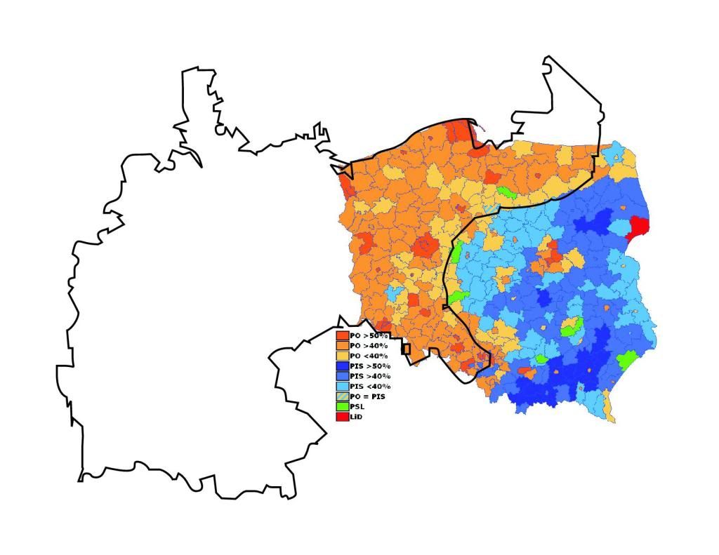
These patterns are not random. Take a look at pre-WWI Imperial Germany superimposed upon this map:

Analyzing Polish Elections

As the map above indicates, there is a powerful correlation between the borders of Imperial Germany and support for the free-market, pro-Western Civic Platform (PO) Party. In contrast, areas that voted strongest for Law and Justice (PiS) used to belong to the Austrian-Hungarian and Russian empires.

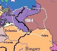
An exact map of Poland’s pre-WWI boundaries looks as so:

Analyzing Polish Elections

These voting patterns have very little to do with any actual German presence in pro-Civic Platform regions. Few Germans live in the regions that used to belong to Imperial Germany; after WWII the process of ethnic cleansing effectively expelled them all from modern-day Poland.

The reason, rather, involves economics. The German Empire was far more economically developed than the Russian and Austria-Hungarian empires. This legacy is still present today, as Poland’s 2007 parliamentary elections showed quite starkly.

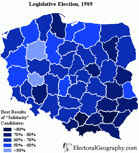
An interesting instance of Poland’s “German” divide occurred during the 1989 parliamentary elections. One may recognize this date: it was the year that communism fell in Poland. In these elections the Polish communists actually competed directly with the anti-communist Solidarity movement.

Here are the results:

Analyzing Polish Elections

Solidarity, of course, won in a landslide victory – which is why communism fell in Poland. Yet even in these elections one can make out the regional, east-west divide in Poland. Surprisingly, the more “Western” and economically developed regions actually gave stronger support to the Communists.

All in all, Poland’s electoral divide provides a powerful example of how long-past history can influence even the most modern events. Whatever the political parties of Poland’s future, and whatever their political positions, one can be fairly sure that Polish elections will continue to replicate the boundaries of pre-WWI Germany for a long, long time.