• FL-Sen: Biden alert – confirmed! There was a rumor that Joey Jo-Jo Biden Shabadoo would soon be doing a fundraiser for Bill Nelson. It turns out he’s doing two, on March 25th: One near Orlando and the other in Tampa.
• OR-01: Not a particularly good addition to the resume for Rep. David Wu (D). As The Oregonian puts it, Wu “crashed his vehicle into a parked car in Northwest Portland last year, but passed a police field sobriety test and the incident never showed up in a police report.” A police official notes that a lack of a report is not uncommon, and says that Wu didn’t identify himself as a congressman.
• VA-11: Republican Keith Fimian, who lost to Rep. Gerry Connolly in 2008 and 2010 (by a whisker), says he’ll run again – but only if the 11th CD “redistricts well,” something he doesn’t expect to happen… nor should he, given the likelihood that the state lege will adopt an incumbent-protection map.
• LA-Gov: He doesn’t have any declared opponents for the November election, he’s got an astounding $9 million in the bank, and Democrats have been getting their asses kicked in Louisiana for years, but that’s not stopping Gov. Bobby Jindal from going on the air with his first television ad. The buy, according to a Jindal spokesman, is for “six figures,” so I guess that means anywhere from $100,000 to $999,999.
• SC-LG: Republican Lt. Gov. Ken Ard has just been charged with 92 counts of violating ethics rules, in which he’s accused of putting campaign money to personal use and failing to properly disclose his spending. Among other things, Ard spent campaign funds to attend the SEC championship football game in Atlanta last year (the University of South Carolina got crushed), and he also bought his wife a gown to wear to the state’s Inaugural Ball.
• Wisconsin Recall: The linked article has some vague but somewhat more specific figures on the number of signatures gathered in the recall efforts. One interesting detail: If some collection efforts finish earlier than others, that means we could have staggered recall elections. I personally think we’d be better off waiting to submit all our signatures at once so that we can have a unified effort. (And also, we should keep gathering sigs until the last day, to ward off challenges.)
Greg Sargent also has a new version of an ad in support of the recall from the PCCC and DFA (NWOTSOTB). Oddly, the final title card calls out Alberta Darling, Glenn Grothman, and Mary Lazich by name – but as you’ll recall, Grothman and Lazich are the two pretty much untouchable senators, thanks to their super-red districts.
On a related note, Think Progress observes that Michigan’s state constitution has similar recall provisions to those in Wisconsin. Republican Gov. Rick Snyder is also pushing anti-union legislation there, and he and his allies in the legislature could be subject to a recall movement as early as July.
• WI Sup. Ct.: In other Wisconsin news, Republican Supreme Court Justice David Prosser is up with an oddly narrated ad that touts some healthcare-related decision he once made. I find it pretty gross and unseemly that high court judges are elected in the first place, and to see them speaking of judicial decision-making in such nakedly political terms is disturbing. But it’s the system we’ve got – and with any luck, Democrat JoAnne Kloppenburg will have a fighting chance against Prosser in next month’s election.
• Models: Harry Enten has published a model for forecasting the results of House races in presidential years. He predicts that Republicans will win 238 seats, which, assuming the GOP holds NY-26, would mean a loss of only four seats for the party in power. But the model has a margin of error of ±10 seats, so conceivably the Republicans could hold as many as 248 seats and as few as 228. Obviously, you’ll have to click the link for the full details of Harry’s model.
• Votes: Seven House Republicans voted against banning all federal funding to NPR: Rob Woodall (GA-07), Chris Gibson (NY-20), Richard Hanna (NY-24), Pat Tiberi (OH-12), Steve LaTourette (OH-14), Dave Reichert (WA-08), and Sean Duffy (WI-03). Weirdo teabagger Justin Amash (MI-03) voted “present.” And yeah, I had to look up Rob Woodall, too: He’s the freshman who replaced the retired John Linder last year (Woodall was Linder’s chief of staff). This vote really stands out because GA-07 is one of the reddest districts in the nation (it gave 40-point margins to Bush, though “only” 20 to McCain), and all the others on this list have quasi-semi-some-of-the-time moderate reputations.
• WATN?: In case you really care about Joe Miller, I guess you can click the link….
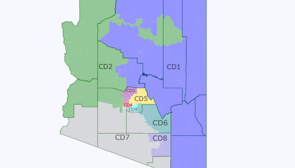
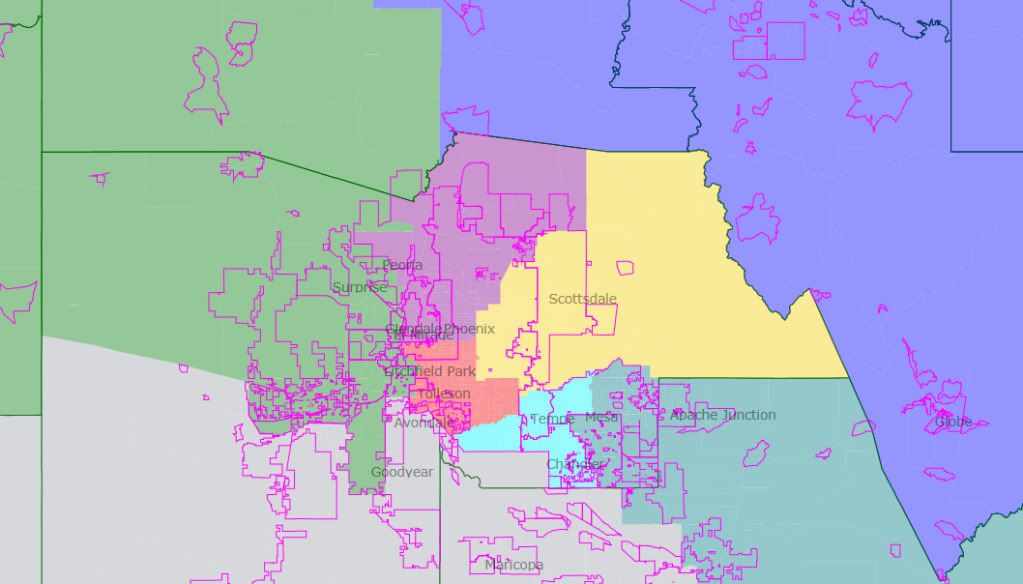
Redistricting Roundup:
• Louisiana: State Rep. Rick Gallot, who chairs the LA House’s redistricting panel, released three different preliminary proposals. (Scroll down to the bottom for PDFs of the maps.) All of the plans involve pitting Republican incumbents against each other: two of the maps throw freshman Rep. Jeff Landry in with Charles Boustany; the third combines Landry with Bill Cassidy. A fourth plan (not linked in the article) by Rep. Joe Harrison (R) would combined John Fleming and Rodney Alexander. By the way, Gallot is a Democrat, yet he’s apparently heading up the GOP-controlled House’s redistricting efforts. Louisiana confuses me.
• Mississippi: Uh, wow. Dem House Speaker Billy McCoy absolutely flipped out and seems to have turned what was a winning situation for the Dems into a disaster. For a moment there, it looked as though Republicans (who control the Senate) were ready to agree to incumbent protection plans for each chamber – and give the kiss-off to Lt. Gov. Phil Bryant, who wanted to take a more aggressive approach. But McCoy crumbed the play, releasing a statement saying… well, click the link for the whole thing – it’s really berserk. He says he won’t recognize any further maps from the Senate, he considers the whole thing a done deal, and he’s sending the maps to the Department of Justice for preclearance – even though they haven’t been passed into law! I have a strong feeling that he’ll get an envelope back marked “Return to Sender,” but the more important fact is that this now strengthened Bryant’s hand and probably makes Senate Republicans much more likely to jettison a bipartisan gerrymander and take Bryant’s approach. Ah, well, it’s just delaying the inevitable – even with the most favorable of maps, I can’t imagine Dems in MS holding the House for very long.
• New Jersey: It’s a classic problem, and one that puts Republicans in the rare position of siding with minority communities, while the Democrats are on the outs. Hispanic and Asian political leaders in New Jersey are unhappy with their communities’ under-representation in the legislature, and they want to see more majority-minority districts drawn. Republicans are all too eager to help – and Democrats are, of course, unhappy, because that means packing Dem voters into darker-blue districts, rather than spreading them around to make more seats competitive. This is a miniature, state-level version of what happened in the early 90s on the federal level and reflects an ongoing, hard-to-resolve tension.