GERRYMANDERING (movie) – World Premiere Tribeca FF

Greetings all –

I’m the writer/director of a new feature-length documentary about redistricting, a subject which I know is near and dear to many hearts here.  It’s called, aptly, GERRYMANDERING.  I’ve been working it now for about five years and the film will have its world premiere two weeks from today in the Discovery section of New York’s Tribeca Film Festival.

In the course of making the film, I got in touch with DavidNYC who provided terrific advice here and there.  When I let him know about the premiere he suggested I diary about it, so here goes…

GERRYMANDERING World Premiere!

Tribeca Film Festival 2010

Tuesday, April 27, 6:00 pm, Village East Cinema (181 Second Avenue at 12th Street)

Tickets are available now for Amex cardholders: http://www.tribecafilm.com/fes…

General tickets go on sale 4/19.  

If you can’t make the premiere, we’ll screen three more times:

Wednesday, April 28, 5:30 pm, Village East

Friday, April 30, 7:00 pm, Clearview Chelsea  (260 West 23rd Street (between 7th and 8th Avenues)

Saturday, May 1, 10:00 pm, Clearview Chelsea

Here’s the Tribeca FF description:

What is “gerrymandering”? You don’t have to wait for your oversized 2010 census envelope to figure out what exactly it means. Named for the Massachusetts governor who conveniently redrew a few erratic lines in 1812, gerrymandering is the redistricting of electoral boundaries to effect voting outcome in favor of a particular candidate, political party, et cetera. And why should you care? As the governor of California will tell you, the reestablishment of district lines takes away the voice of individual communities, reduces voter turnout and lessens competition among candidates. Whether it’s a community, race, or party issue, an issue it surely is.

Director Jeff Reichert gathers an impressive bevy of experts to smartly present a well-rounded exposé. From California’s struggle to pass Prop 11 to The Daily Show’s mockery of a gaggle of border-jumping Texas politicians, this accessible and informative documentary encourages us to put on our bifocals and more closely inspect the warp and woof of America’s democratic system.

–Ashley Havey

Residents of California, Florida, Texas, Iowa, DC, New York, Massachusetts, Louisiana or Oklahoma will recognize a lot of our shooting locations.  (Hopefully we’ll be able to get the film to the rest of the country soon).

For more info (and a quick, somewhat old teaser trailer) check out our website: www.gerrymanderingmovie.com

And if you have specific questions about the film, I can try to answer them in the comments…

By what margin will Bob Shamansky win?

View Results

Loading ... Loading ...

PBI (Party Brand Index) Part 8: Florida

PBI or Party Brand Index is a concept I developed (with some much appreciated help from pl515) as a replacement for PVI.  PVI (Partisan Voting Index), which is measured by averaging the percentage of the vote from the last two presidential elections in each house district, and comparing it to the nation as a whole, is a useful shorthand for understanding the liberal v. conservative dynamics of a district. But PVI in my opinion it falls short in a number of areas. First it doesn’t explain states like Arkansas or West Virginia. These states have districts who’s PVIs indicates a Democrat shouldn’t win, yet Democrats (outside of the presidency) win quite handily. Secondly why is this the case in Arkansas but not Oklahoma with similar PVI rated districts?

Lastly PVI can miss trends as it takes 4 years to readjust. The purpose of Party Brand Index is to give a better idea of how a candidate does not relative to how the presidential candidate did, but compared to how their generic PARTY should be expected to perform. I’ve tackled IN, NC, CO, VA, MO, OK, AR, WV, NH,and OH. Now I will look at the swing state of Florida.

I had to take a break from my analysis for personal reasons. Like always I would like to post the data, then I will offer some analysis. My basic pattern is to work my way “out” from the “Purple States” to the more Blue and Red ones. (Although once in a while I like to skip my normal pattern of working out from purple states.  I’m often curious on how my model would work in states like that are deeply blue at the local level, but deeply red at the presidential level.) As a reminder a negative number indicates a Republican bias to a district, while a positive number indicates a Democratic bias.

Let’s examine the swing state of Florida, the second large state I have examined (Ohio was the first).

FLORIDA PART 1

FLORIDA PART 2

FLORIDA PART 3

ANALYSIS

Unlike most other states I have examined Florida has very little deviation, from the PBI and PVI. This may be the result of the Floridian GOP’s very effective gerrymandering of house districts after the 2000 census. In fact there are only two districts where the PBI and PVI deviate. One is in Democratic Rep. Kosmos (FL-24). Interestingly enough this district was designed to elect a Republican although it’s not represented by a Democratic. The other is in Democratic Rep. Alan Boyd (FL-02), I think the PBI is a little high. This will be examined in the next batch of Blue Dogs I examine.  

The only hope for “new ground” for Democrats may lie in a swing in the voting preference of Cuban-Americans as a younger less “single issue” group of voters come of age. Also the makeup of many of these Latino districts are changing as more Puerto Ricans and Dominicans move in.

One final note, as I alluded to earlier, after I come across a few “conservative” Democrats, I run a “correction” factor to account for them being Blue Dogs. The general idea is that the distance they are able to maintain from the national party may help them win over voters who are more reluctant to vote for Democrats. I want to examine another swing state before I “recompute” Ohio’s Blue Dogs.

As a recap, here are the first “batch” of Blue Dogs, and rural Democrats (West Virginia’s Democrats aren’t members of the Blue Dogs) that I examined correcting for partisanship and ideology.

FOUR BLUE DOGS

THREE BLUE DOGS

As a reminder ranking a members ideology is a somewhat subjective decision. Potentially what’s one person “liberal” position, is another person “conservative” ones, remember the wingers developed a model that ranked the Sen. Obama as more liberal than Bernie Sanders or Russ Feingold. But partisanship, how often a member votes with their party is an absolute number. A Democrat who represents a “republican district” would be expected to “break with their party” on votes that don’t reflect their districts values.

I couldn’t find a website that ranks all the districts based on their PVI (I only could find list of them by state not rank, help please anyone), therefor I substituted a PVI ranking with where each member ranked in the Democratic caucus. In the 110th Congress the average Democrat had an ideological ranking of 170 (by the way this is a result of several members being tied, this is the medium not the midpoint). The average of members towards the center was 191, former Daily Kos celeb Ciro Rodriguez fell at exactly 191. The average of members towards the liberal side was 121, which falls between Rep. Larson of Conn. and Rep. Eshoo of CA. As or partisanship in the 110th Congress the average Democrat voted with their party 92.3% of the time.

As a clarification in Adjustment #1, I used a deviation factor based on how far each member was from the center of the Democratic caucus. Adjustment #2 was based on how far each member was from outside the standard deviation of the caucus. In Adjustment #3 I removed the partisanship factor to see what effect it would have. As I explained a few diaries ago I will use ADJUSTMENT FACTOR 2 in all subsequent corrections.

Because there are “only” 50 states (as opposed to evaluating 435 house members), I will at a later date have all the states ranked by PVI so I can adjust the Senator’s rankings. I developed Senate factors for the four states the four blue dogs came from. In the interest of full disclosure, my source for ideological rankings is Voteview, and for partisanship it was the Washington Post. This is still a work in progress, I’m making adjustments, and continuing to crunch numbers for more states. I also will use the adjustment factor on a liberal member of congress to see what effect that will have.

Anthology:

PBI (Party Brand Index) Part 7 Ohio

PBI (Party Brand Index) Part 6 WV and NH

PBI (Party Brand Index) Part 5 Nevada and Iowa

PBI (part 4) MO, AR, OK

Party Brand Index (part 3) North Carolina

Party Brand Index (part 2) Colorado and Virginia (updated)

Introducing PBI, Party Brand Index (Updated)

Florida, Part 5

By: Inoljt, http://thepolitikalblog.wordpr…

This is the last part of an analysis on the swing state Florida.

Miami-Dade County

Here is how John Kerry did in south Florida:

Photobucket

Here is how Barack Obama performed:

Photobucket

Broward and Palm Beach are marginally smaller, when compared to Obama’s performance. The big difference, however, is with Miami-Dade. Kerry won it by 6%; Obama won it by 16%.

There is no other place in Florida (and, perhaps, the country) like Miami-Dade. Palm Beach and Broward counties are retiree destinations; Miami is home to immigrants and refugees from all Latin America. More than 60% of the population is Latino – and only 3% of them come from Mexico. The Miami accent is unique compared with the nation. Local government is distinct from other counties in Florida.

One would expect Miami to be one of the most Democratic places in the nation, much like New York City or Chicago.

It is not.

Continued below the flip.

Obama won the five boroughs of New York City by 59%: a 4 to 1 margin. He won Cook County (Chicago) by 53%, with more than three-fourths of the vote. In contrast, Obama took 58% of Miami-Dade county – less than the amount by which he won New York City. The 2008 Democratic performance in Miami is comparable to their performance in cities such as Dallas (57% of the vote) and Sacramento (58% of the vote).

Much of this is due to the Cuban vote, the city’s largest demographic group. Refugees from Castro’s Cuba, staunchly anti-Communist, and faithful Republicans ever since the Bay of Pigs fiasco; Cubans vote as strongly Republican as Jews vote Democratic. In 2000, George W. Bush won about four out of five Cubans, helped by Cuban anger over Al Gore’s role in the Elian Gonzalez affair. In 2008 Obama won around 35% of their vote, based on exit polls. This was the best performance of a Democrat with Cubans in recent memory.

Their influence ensures that Miami remains a competitive, Democratic-leaning city. Democrats usually end up winning it, but their margins are severely cut. And occasionally it will turn up in the Republican column – as happened during the 2004 Senate race. There, Mel Martinez, a Bush ally, won Miami-Dade on his way to a one percent victory.

Photobucket

Democrats often hopefully comment that demographic shifts will slowly move Cubans leftward, as a new generation of Cubans, less concerned with Castro and communism, replaces their more militant elders. Perhaps. But that process will be the work of decades, not a single election cycle. For the moment the Cuban vote remains strongly Republican.

In 2008 the Democrats challenged two entrenched, Republican congressmen in south Florida: the Cuban Diaz-Balart brothers. The races were closely watched, so much that the New York Times Magazine aired an article dedicated to them. In the end, both Republicans won by margins larger than expected. Their continuing presence points to the steadfastness of the Cuban Republican vote.


Conclusion

Of the three most commonly cited swing states, Florida is the most conservative. The state can be divided into unique blocs, each of which has a distinct culture. The first, northern Florida, shares much/is part of the Deep South. Voting patterns reflect this. The populous I-4 corridor – Florida’s so-called swing-region – leans Republican, although Democrats perform well in Tampa Bay and Orlando. Finally, south Florida – diverse and populous – is the Democratic base, although the Cuban vote in Miami blunts their strength.

Whether Florida will remain this way is uncertain. Florida is an immense and diverse state. It is home to the Panhandle and Miami – two places opposite as night and day. Most every part of America can be found in the varied peoples that reside there. And certainly, it will continue to be an important swing state, sought after by both parties. Whoever ends up winning Florida is well on his or her way to becoming president.

Florida, Part 4

By: Inoljt, http://thepolitikalblog.wordpr…


This is the fourth part of an analysis on the swing state Florida.

Photobucket

The Miami Metropolis

Diverse, populous, sun-baked – south Florida is far different from the rest of the state. It is the Democratic base, where liberals win their biggest margins.

Like most liberal places in this country, south Florida contains incredibly diversity; ethnic minorities compose a large share of the population. The region as a whole has reached majority-minority status. Blacks, Jews, Latinos ranging from Cubans to Nicaraguans, and many others call south Florida home.

Urban and densely populated – again, a trait common to Democratic-voting regions – South Florida is the seventh largest metropolitan region in the country. Most of its population resides along Florida’s southeastern shore, on a strip of land often only a few miles wide. More people voted in Miami-Dade and Broward than any other county out of the three swing states being reviewed (Florida, Ohio, and Pennsylania). Both counties are part of south Florida.

Photobucket

If south Florida, with its vast population, behaved like liberal Philadelphia, John Kerry would be president of the United States and Barack Obama would have won the state by double-digits.

That does not happen.

Continued below the flip.

While Palm Beach County and Broward County (the two top counties in south Florida) are solidly Democratic, they are far and away from the most liberal places in the country. Palm Beach, like many liberal-leaning suburbs, gives Democrats a 3:2 edge. Broward, a deeper shade of blue, gives Democrats two-thirds of its vote. Both places have voted this way consistently for the past four elections. Miami-Dade county, which is culturally and economically an entity by itself, behaves somewhat differently.

Here is how Barack Obama did in the Miami metropolis:

Photobucket

Like most Democratic candidates, he obtains huge margins. Compare the size of the circles here to those in the I-4 corridor (this can’t be done regarding northern Florida, unfortunately). They’re a magnitude bigger.

Several demographic factors lie behind Democratic strength in Palm Beach and Broward, the top two blue circles (Broward is the middle one). Palm Beach has a substantial black population, slightly above the national average. Latinos also compose a double-digit voting bloc – although many are Cubans, diluting their impact. Moreover, Palm Beach is the wealthiest county in Florida. While not all extremely rich areas vote Democratic, as a whole they tend to be bluer than the country at large.

Then there is the Jewish vote.

More Jews live in south Florida than anywhere else in the world, except for the state of Israel. Most are retirees living out their golden days in sunny Florida. Jews, much like their Catholic brethren, have a long history of voting for Democrats. In today’s world, their leftward stances on social issues drive them to Democrats. Mike Dukakis was the last Democrat to win less than 70% of the Jewish vote. The last Republican to beat a Democrat amongst Jews was Warren Harding, in 1920. And that was because 38% of them voted for a socialist.

Photobucket

Up to 20% of Palm Beach County is Jewish, an important Democratic advantage. This constituency gave Obama 78% of the vote in 2008, contributing heavily to his overall victory. In neighboring Broward County, approximately 12-13% of the population is Jewish (a decrease in recent years). There too, Jews helped increase Obama’s margin in the county.

Broward County is similar in many respects to Palm Beach. It is one of Florida’s wealthiest counties. Latinos comprise more than one-fifth of the population (although, again, there are many Republican-leaning Cubans). There are a number of Jewish voters, as noted previously. Finally, African-Americans comprise slightly less than one-fourth of the population. Their relatively larger presence translates to a stronger Democratic vote compared with Palm Beach.

A final note. In 2000, Al Gore chose Senator Joe Lieberman, a Jewish-American, as his running mate. In large part due to this, he performed extraordinarily well in Palm Beach and Broward; Lieberman’s presence ensured unusually high Jewish support. In fact, Gore did better than Obama in the two counties, despite Obama’s far stronger national performance.

Florida’s razor-thin margin in 2000 is a major reason pundits today regard it as a swing state. However, as the above analysis indicates, much of Gore’s strength was unique to him (or rather, his running-mate). Relative to the generic Democrat, Gore overperformed. This was why John Kerry’s campaign, which competed so hard in Florida, was taken aback by the margin he lost by. To this day, Democrats assume that Florida is a more liberal place than it actually is. Al Gore, Joe Lieberman, and the Jewish vote are largely responsible for this.

Florida, Part 3

This is part three of a series on the political structure of the swing state Florida.

The I-4 Corridor

If there is a holy grail of Florida politics, it is winning the I-4 corridor. This refers to the Interstate 4 highway, which begins in Tampa Bay, travels though Orlando, and ends in Daytona Beach.

Quite a lot of people live in the I-4 corridor. It’s far more populated than northern Florida (and northern Florida itself is relatively dense compared to other parts of the South). While parts of south Florida are far more people-heavy, as an aggregate central Florida has a slightly greater population. The I-4 corridor can be compared to a gigantic suburb, with an unusually high number of retirees. Granted, there are cities, but they are more alike to Phoenix (which is really just a big suburb with skyscrapers) than New York.Photobucket

The picture above indicates counties in which more than 100,000 votes were cast in 2008; it is a rough indication of voting density. There are a scattering of counties with more than a hundred thousand voters in northern Florida; actually Obama does quite well in the highlighted counties. Most of south Florida is also yellow. Then there is an empty region – the Everglades. And above that is the I-4 corridor, which is nearly entirely highlighted. The center yellow counties are actually a rough definition of the I-4 corridor.

The I-4 corridor is often considered to be the “swing” region of Florida. The metropolitan areas that lie inside it are the heart of central Florida, and they have enormous importance. The percentage by which a politician wins the I-4 corridor often mirrors his overall performance in the state.

Continued below the flip.

For a so-called “swing” area, though, central Florida is quite conservative. It can be characterized, like Florida itself, as a Republican-dominated region with a few Democratic strongholds. The “average” county in central Florida leans Republican, with a few exceptions. And remember, the “average” county is quite populated.

What are the “exceptions,” the parts of I-4 that lean Democratic? They’re generally more populated than the mean. They have high levels of minorities. They’re places like Tampa Bay and Orlando. Osceola County has a large Puerto Rican community; it leans Democratic. Democrats sometimes do well in the communities north of Tampa. To be clear, “doing well” means winning these counties by ten percent or so; Democrats generally don’t pull off 60% or more of the vote anywhere in the I-4 corridor unless it’s a landslide.

Here is the performance of a relatively weak Democrat, John Kerry, in the I-4 corridor:

Photobucket

John Kerry gets absolutely pummeled. There is a sea of red counties. This is the reason why John Kerry lost Florida.

Here is the performance of a stronger Democrat, Barack Obama:

Photobucket

He does better. Obama’s probably winning the I-4 corridor, largely due to his landslide victory in Orlando – where he took 59% of the vote, the highest Democratic performance since 1944. Still, it’s a very very close thing (actually, Obama’s only leading by several thousand votes if one adds up all the counties pictured). Compared with how the Democrats did nationally, winning by 7.2%, that’s a very unimpressive result.

McCain and Obama essentially ran even in central Florida, or Florida’s “swing” region. They also ran even in Missouri, Indiana, and North Carolina. To say that the I-4 corridor is as conservative as North Carolina is an eye-opening statement. But the data backs it up.

There is hope for Democrats, nevertheless. The type of conservatism typified by central Florida seems like a softer, more suburban type of conservatism. Central Florida voters are probably more accepting of Democrats and willing to vote for them. Republicans won most counties in the I-4 corridor – but they did by 10 points, not by 40. Using an analogy earlier from this post, Central Florida Republicans are more akin to Phoenix Republicans than their northern Florida counterparts. While the I-4 corridor didn’t vote for Clinton in ’92, it did so in ’96. In contrast, the conservatism typified by northern Florida and the Deep South is deeply ingrained and rock-hard. Only a tidal wave can change voting patterns there.

Moreover, demographic change may shift central Florida leftward. This is especially evident in Orange County (Orlando) and Osceola County. In 1992, Orange County gave George H.W. Bush one of his largest margins in central Florida; he won it by double-digits. In 2008, it was Obama’s best-performing county in the region. The U.S. Census estimates that around 40% of the population is black or Latino, highly Democratic voting blocs. Rapid Puerto Rican immigration into Osceola County, too, has led to a nearly 30% voting shift since 1992, according to the Times.

For the moment, nevertheless, the I-4 corridor is roughly as conservative as North Carolina in terms of votes. To summarize so far: northern Florida, commonly considered the Republican base, is as red as the Deep South. Not parts of the Deep South; the Deep South as a whole. The I-4 corrider, which is called Florida’s “swing” region, swings blue just as much as Indiana, Missouri, and North Carolina did in 2008. Historically, it’s probably been closer to Missouri; to call central Florida as red as Indiana or North Carolina is probably an overstatement.

Miami, as we shall see, is about as liberal as Dallas and Sacamento.

–Inoljt, http://thepolitikalblog.wordpr…

Florida, Part 2

Photobucket

Florida can be considered as three regions distinct in culture, economics, and voting patterns. Northern Florida is deep red; the I-4 corridor is light red; and the Miami metropolis is moderately blue.

Until recently, Florida was far different from what it looks like today. It was the quintessential Southern state, and it was fairly empty in term of people. Florida’s voting record reflected its southern roots. Until Eisenhower won it twice, Florida was part of the Solid South. In 1964, LBJ ran well behind his national average, due to his support for civil rights. The next election, George Wallace took 29% of the vote. Then in 1976, Jimmy Carter resurrected the Solid South for the last time, winning Florida by 5%. That was also the last time a Democrat ran above the national average in Florida.

Northern Florida and the Panhandle

Florida still is a Southern state to some extent. This is especially true in northern Florida and the panhandle, which borders Alabama and Georgia. Northern Florida is very conservative; it is not uncommon to see a Republican taking 70% or more of the vote in a number of counties there.

Photobucket

As the picture indicates, northern Florida constituted the place in which McCain performed best. There were no counties in which Obama won over 70% of the vote, although he comes fairly close in majority-black Gadsden County (where he won 69.1% of the vote).

Gadsden County provides a neat encapsulation of all that makes northern Florida tough going for Democrats. Like much of the Deep South, voting is racially polarized. If a county is like Gadsden, it votes blue; if, on the other hand, a county does not have many blacks, it is usually deep red. There are not many independents in this region; voting habits are deeply entrenched. The “average” voter and the “average” county is a hard-core Republican.

The result is something like this:

Photobucket

This is northern Florida in the 2008 presidential election.

There are three noticeable blue areas (out of five Democratic counties). One is Gadsden County, which is majority black. The other two are homes of major public universities: Tallahassee hosts Florida A&M University and Florida State University, while Alachua County is home to the University of Florida.

This is the Democratic “base,” such as it is. Blacks and college students have historically been the most faithful Democrats, and in northern Florida they are the only Democrats.

A final note before moving on to central Florida. Although Jacksonville most always votes Republican, there is a substantial black minority within it that, unfortunately, has had historically poor turn-out. A strong Democrat can mobilize these voters and essentially erase Republican margins in this county. Barack Obama was extremely successful at doing so, which is why the red circle is relatively small in the map. On the other hand, John Kerry was not as successful; he lost Jacksonville by 17 points, as the picture below indicates.

Photobucket

–Inoljt, http://thepolitikalblog.wordpr…

Florida, Part 1

In 2008, Illinois Senator Barack Obama won Colorado by 9.0%, Florida by 2.8%, and Indiana by 1.0%. Guess which one was the “swing state” in 2004.

The answer is Florida, and if that seems strange in light of the above – it is. In fairness, one might counter that Obama did relatively poorly in Florida (where he didn’t campaign in the primaries) and relatively well in Colorado (where the Democratic convention was held).

Here’s another question. Colorado, Florida, Indiana. Only one of these three sends a majority-Republican delegation to the House of Representatives. Which one is it? (A hint: it’s not Indiana.)

It turns out that Florida elects 15 Republican congressmen and 10 Democratic congressmen. Again, to be fair, one might note that Florida’s Republican-controlled state legislature gerrymandered Florida’s congressional districts to achieve an unbalanced result. This is relatively easy – most Democrats live in tightly clustered South Florida.

But that’s just it: Florida’s state legislature is Republican-controlled. In fact, Republicans have 60%+ majorities in both chambers. Florida’s governor is Republican Charlie Crist. Florida was voted Democratic in only two of the last eight presidential elections. John Kerry’s campaign was shocked by the margin he lost by in Florida. Bill Clinton won Georgia, of all states, while losing Florida in1992.

To be fair, I’m picking and choosing my numbers. If you go back to the past nine presidential elections, you’ll find Democrats batting three for nine, not two for eight. And three of those eight elections were big Republican victories.

But there’s only so many times one can say “to be fair.” There’s only so many excuses one can make for yet another indication of Republican dominance in Florida.

Because the closer one inspects as Florida, the more it begins to look less like a swing state than a conservative state with an unusually big Democratic base – which the media happens to call a swing state.

In the next section, I’ll be analyzing why exactly this is so.

A “Fair” Florida Map

Florida

The Scenario:

If Alex Sink or another Democrat were to capture the Governorship, I can easily see them letting a judge draw the maps-they can seldom get anything worse than what the map currently is and they would almost certainly gain more seats then they would in an incumbent protection map. I also assume that Florida only gains a single seat, rather than the 2 some are predicting (opinion is widely split on that).

So, here goes. I know my FL-4 will spark a lot of controversy.  

North Florida (Districts 1-6)

FL-1: A very conservative Pensacola based district and a cakewalk for Jeff Miller.

FL-2: A modestly more Democratic friendly version of the 2nd which Allen Boyd should have no problem with.

FL-3: Ander Crenshaw should love this heavily GOP district with its base in the Jacksonville suburbs and exurbs.

FL-4: Replaces the old Florida 3rd; entirely within Duval County and is 33.8% African American, compared to the 49% it is now. Would it trigger a lawsuit? Almost certainly. However, there is absolutely no way to draw a black majority district in North and Central Florida. I spent four hours trying and got something that was like 48% black and looked like an octopus. Since the Supreme Court has ruled in Bartlett v. Strickland that a district must be 50%+ minority to be protected under the VRA (unless I’m misreading the decision). Thus, I went for compactness while keeping the minority heavy parts of Duval together. It should be winnable for a black Democrat, as they would be favored in the primary, and I can’t imagine the GOP winning a 34% African American urban district (when you add in Latinos, minorities are 38% of the district).

FL-5: Similar to the current 5th, though more North and Central Florida than exurban Tampa. Should elect Ginny Brown-Waite or another GOPer easily.

FL-6: One of the more interesting new districts created out of parts of the current 3rd, 6th, and 7th. Its basically a battle of bases, with the GOP being strong in the St. Johns part of the district and Dems having all of Alachua County. The Marion County portion though, gives this district a slight GOP lean, though I can absolutely see a moderate to Blue Dog Dem winning this seat.

The I-4 Corridor

(FL-7 to FL-12 and FL-24)

FL-7: Suburban Orlando, taking in parts of Seminole and Osceola Counties. I would expect this to be something like a 53-47 Democratic district.

FL-8: Orlando’s downtown core and some suburbs. Allen Greyson will love it.

FL-9: Suburban Greater Tampa. Probably would elect Gus Bilrakis again.

FL-10: A significantly more Democratic version of the current district. If Charlie Justice gets elected next year, he’ll love this district.

FL-11: Tampa’s downtown core and some of suburban Hillsborough County. Probably less Dem than its current configuration but still plenty safe for Kathy Castor.

FL-12: A Hillsborough-Polk Tampa suburban district that looks like a tossup.

FL-24: A Volusia/Seminole based district that would elect Suzanne Kosmas.

South Central Florida

FL-13: A Sarasota County based seats with large hunks of Charlotte and Manatee Counties. Leans to likely Republican.

FL-14: The leftovers district. A Republican lock, though I’m pretty sure it has no incumbent.

FL-15: Republican Brevard and Indian River Counties plus the leftovers of Osceola. Bill Posey, with his wingnuttia could make it extremely interesting.

FL-16: Democratic St. Lucie plus marginally Republican Martin and a big chunk of north Palm Beach County. On paper, its Democratic leaning.

FL-17: Fort Myers based. Connie Mack is safe.

Southeast Florida (West Palm Beach, Broward, Miami-Dade)

FL-18: A Democratic South Palm Beach County seat. My guess is Robert Wexler runs here.

FL-19: A much safer district for Ron Klein.

FL-20: A Dem friendly district for Debbie Wasserman Schultz.

FL-21: A black majority district for Kendrick Meek’s successor, though I had to strip out some African American precients to get Alcee Hastings over the 50% hump in the 23rd.

FL-22: Cubans in Miami and down the coast, but wholly in Dade County. Possibly the safest of the 3 Cuban districts now.

FL-23: Basically the same as is now.

FL-25: Hialeah based, Joe Garcia stands a much better chance in this version of the district.

FL-26: What’s left of Dade and Collier plus the Florida Keys.

Results:

Dems hold everything they have now and probably pick up the Florida 7th, at least one of the Cuban Districts (I’d bet on the 25th), and maybe the 12th. A Dem will carry my new 10th as well.

The 6th is a tough GOP hold, and Bilrakis could have trouble in the new 9th. Posey is capable of turning a relatively safe 15th into a battleground.

GE 2008, the Democratic pick up states: an exhaustive summary analysis

Now that all 9 Democratic pick-up states plus NE-02 have been analysed, I have also provided an exhaustive and most unique non-partisan summary of the pick-up states. I can guarantee you that there is information in this summary that you will not find anywhere else in this quality, clarity or combination.

There are a number of side-documents that go with the summary, plus links to all of the nine analyses and the GE 2008 final analysis for the entire Union.

I want to explain again that I have farmed this kind of thing out to Google Docs as it makes it easier for me to publish charts, tables and graphics. It is my hope that you will read the summary in it’s entirety. There are surprises all over the place that only become apparent when one scratches under the surface and researches the GE 2008 at the county level, county for county. In the case of the 9.25 pick-ups, we are talking about 696 counties.

The summary is divided into 2 parts and all of this information is after the jump.

Part I of the summary contains:

– links for the individual analyses for all the pick-up states plus the links for the GE 2008 analysis for the entire Union are given again. They will be reproduced at the bottom of this diary entry.

– an overview of the raw vote and percentage totals for the pick-ups states, first for 2008 only and then a comparison to 2004.

– three maps. One shows the geographic position of the pick-ups within the USA. The second shows the geographical relationship between the pick-ups and the Democratic retentions from 2004. The third shows the Democratic states from 2008 plus the 5 leanest GOP wins from 2008.

– a question: “How does this compare on a historical level?”

The question is referring to the number of electoral votes that changed parties in 2008, namely, 113 EV. I then provide a table showing each general election back to 1948 and how many electors changed parties, and in which direction. The answer to the question is that Obama’s EC shift is on par with the last election cycle, but less than in the 1980s.

Afterward, there is an introduction to the county-level analysis, including an exact numeric count of counties per state: Democratic retentions, Democratic pick-ups, Republican retentions and Republican pick-ups.

Quote:

“In the pick-up states, the Democratic party retained 146 of 148 Democratic counties from 2004 and then picked-up an additional 89 counties, for a total of 235 counties (33.76%). The Republican party lost 89 counties from 2004, retaining 459 counties and then picked-up 2 counties, for a total of 461 (66.24%). 235 + 461 = 696 counties.”

“Nationally, all 9 states trended Democratic as Obama won them and their electors according to the WTA (winner-takes-all) system, but when we look at the inner details, the picture is much clearer: 642 of 696 counties in the pick-up states (92.24%) swung Democratic. The remaining 54 counties (7.76%) swing Republican. This indicates a statistical grand sweep for the Democratic party in the pick-up states.

In 4 states, the ENTIRE state trended Democratic: Colorado, New Mexico, Nevada (all three western pick-ups) and Indiana.The pick-up in Indiana is historic not only because this is the first time since 1964 that a Democrat has won the state, but it also had the largest partisan shift of all 50 states in the GE 2008: +21.71%

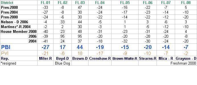
The state with the largest contra-trend (Republican) against the national trend: Florida.”

Part I ends with maps of Ohio, Virginia and North Carolina, showing the geographic position of the 28 counties that swung Republican, showing their proximity to Appalachia.

You can link to Part I via Google Docs.

Part II starts with an extensive study of the 39 largest counties out of the 9.25 pick-ups states, plus Durham County (NC) as honorable mention.

Quote:

“I have done a statistical analysis of the 39 largest counties of the 9.25 pick-ups. These are all counties that had a total vote of more than 170,000 and at least one candidate should have also gotten at least 100,000 of those votes or very,very close to it. All of those counties meet both criteria. Two counties (Stark County / OH, Washoe County / NV) had no candidate with 100,000 votes or more, but in both cases one candidate was very close to 100,000 and the countwide total vote was well over 170,000.  Those 39 counties accounted for 44.49% of the total popular vote of the pick-up states, which is actually slightly LESS than it was in 2004 for the same states: 44.91%. Nonetheless, when only 39 of 696 analysed counties (5.60%, numerically) have almost half the electoral firepower of the region, then it is statistically very clear that the large urban areas have the real electoral firepower in presidential elections. The candidate who sweeps the urban areas has a far better chance of winning the presidency.

Of these 39 counties, there were 21 Democratic retentions, 8 Democratic pick-ups and 10 Republican retentions. This means that of the same 39 counties in 2004, the picture was much more even: in 2004, there were 21 Democratic counties of these 39 and 18 Republican counties.

The Democratic party picked up Hillsborough (Tampa) and Pinellas (Clearwater) counties in Florida, Wake (Raleigh) county in North Carolina, Washoe (Reno) County in Nevada, Hamilton (Cincinnati) County in Ohio, Jefferson (Golden) and Arahapoe (Littleton) counties in Colorado and Douglas (Omaha) County in Nebraska.”

The important thing about this study is it’s depth and breadth: each of the 39 (40) counties are analysed comparing 2008 to 2004, measuring raw vote and margin differences, also the counties’ percentual take of their respective states’ popular vote and also their take of the pick-up states combined. But the counties are also each given a spreadsheet to trace their voting history back to 1960 and the results are nothing less than amazing!

Next, from the analysis in Part II:

Superlatives:

– the largest raw vote total of all 39 counties: Miami-Dade County, FL: 864,636 votes

– the largest Democratic winning raw vote total: Miami-Dade County, FL: 499,831 votes

– the largest Democratic raw-vote margin of the pick-ups: Cuyahoga County, OH (Cleveland): +258,542 vote margin

– the three highest Democratic winning percentages: Denver- CO,  Boulder, CO and Cuyahoga- OH: 75.45%, 72.29% and 68.70%, respectively.

– the three largest Democratic winning margins (by percent): Denver- CO,  Boulder- CO and Cuyahoga- OH: +52.41%, +46.14% and +38.74%, respectively

– the highest democratic margin-shift (swing): Marion County, IN: +26.40% margin shift. This is especially impressive, as this shift was not from a pick-up, but rather, a Democratic retention county.

– the largest Republican winning raw vote total: Duval County, FL: 210,537 votes

– the largest Republican raw-vote margin of the pick-ups: El Paso County, CO: +51,419 vote margin

– the three highest Republican winning percentages: Butler – OH, El Paso- Co and Lee- FL:  60.52%, 58.69% and 54.67%, respectively

– the three largest Republican winning margins (by percent): Butler – OH, El Paso- CO and Brevard- FL: +22.58%, +18.82% and +10.37%, respectively

– the lowest negative Republican margin-shift (swing): Brevard County, FL: -5.73% margin shift

All of the Democratic retentions and pick-ups showed raw vote, percentual and margin GAINS.

All of the Republican retentions showed percentual and margin LOSSES.

4 of the Republican retentions showed raw-vote gains: Brevard, Lee, Polk and Pasco counties, all in Florida. The other 6 Republican retentions showed raw-vote losses.

9 Republican or Democratic tipping-point (margin = less than 4%) counties from 2004 became solid Democratic wins in 2008: Pinellas, Volusia and Orange Counties-FL, Wake, Guilford and Mecklenburg Counties- NC, Montgomery and Stark Counties – OH, Arapahoe County- CO

5 Republican retentions have become tipping point counties for 2012: Sarasota (+0.10%), Virginia Beach (+0.71%), Duval (+1.90), Seminole (+2.70%) and Pasco (+3.75%) . Statistically this means that 1/2 of the Republican retentions studied here are endangered territory for 2012 and (this has been proven historically many times over) in the case of a sucessful re-election campaign for the Democratic party in 2012, these five counties are the most likely candidates to become Democratic pick-ups in 2012.

O Democratic retentions or pick-ups are tipping-point counties for 2012.

Here is the EXCEL SPREADSHEET that has all of the raw calculations for the 39 (40) largest counties.

In order to simplify the look of the table and make the information easier to see, I created a table to show the chronological progression of each county from 1960 to 2008. For each county and year, I have assigned either a D, R or an I, depending on which party won the county in that year. And then I have shaded each cell according to winning party. I then organized the table in order from CORE GOP counties to CORE DEM counties. Take a good, hard look at the table when you read Part II, it is most enlightening.

You can link to Part II via Google Docs.

Quotes:

“In the case of some counties that visually look as if they should be core GOP counties there is instead the marking steady; these are GOP counties that should be core counties, but which almost flipped in 2008, so their status is now uncertain. And some Democratic counties are marked as steady as the margins are very lean.

But the table makes it very easy to see which years are landslide years: 1972 and 1984, to a smaller extent 1992 and 2008. In 1972, we see a sea of red go through all counties except Lucas County, OH. In 1984, we see a sea of red go through all counties except the bottom 5. At the top we see 3 core GOP counties that also resisted the Johnson landslide of 1964. Notice that all three counties are in Florida.

Starting in 1988, the Democratic party started re-building in the urban areas:

3 counties were added to the Democratic column in 1988, resisting the GOP pull in that year: Boulder, Summit and Lucas counties. And those counties have become core DEM counties since then.

8 counties joined the Democratic column in 1992 and have stayed there since then: Palm Beach, Broward, Volusia, Bernalillo, Franklin, Montgomery, Clark, Miami-Dade. They are mostly strong DEM counties, save for Montgomery and Volusia, which tend to go with leans margins. There are 4 more counties that joined the Democratic column in 1992, but were reclaimed by the GOP in either 1996 or 2000: Pasco, Wake, Stark, Guilford. Pasco returned to the GOP in 2004 and has stayed there. It is therefore the only county to complete buck the blue trend, in spite of reduced margins in 2008.

Mecklenburg and Pinellas counties joined the Democratic column in 1996, were reclaimed by the GOP in 2000 or 2004 and were reclaimed by the Democratic party in 2004 or 2008.

Fairfax joined the Democratic column in 2000 and has stayed there since, with ever increasing margins.

Orange and Marion counties joined in 2004 and were retained in 2008. Both of these retentions had massive margin shifts toward the Democratic party in 2008: +18.41 and +26.40%, respectively.

The 8 counties that Obama picked-up are clear to see in the middle of the table. Six of those counties have one thing in common: this is the first time they have gone Democratic since 1964, statistical evidence of a sweep similar to but not as extreme as Johnson in 1964: Hamilton, Douglas, Jefferson, Wake, Hillsborough and Pinellas counties were slightly smaller wins for the Democratic party than in 1964. However, Washoe and Arapahoe counties were larger wins for the Democratic party than in 1964, thus breaking a 44 year record. Notice that both of those counties are in the west.

We can see clearly from the table that the last time a party had flipped 8 counties or more was in 1992, when Bill Clinton picked-up 12 counties. George W. Bush, Jr. picked up 3 counties in 2000 and 1 more in 2004. Those counties returned to the Democratic party in 2000 or 2004.

In 1988- just analyzing these 40 counties- there were 8 Democratic counties and 32 Republican counties. In 1992, out of the same mix of 40 counties, there were 20 Republican counties and 20 Democratic counties, an even split. In 2000, there were 21 Republican counties and 19 Democratic counties. But in 2004, in spite of a republican re-election, the Democrats had 22 counties, the Republicans 18. And now in 2008, it’s 30 Democratic, 10 Republican. There can be no doubt about it: statistically, the urban areas in the Union have moved decisively to the Democratic party in 47 of 50 states (the evidence for which I will present before the end of 2009). This example from the 9.25 Democratic pick-ups is mild in comparison to the statistical data that came out of cities in core Democratic territory: Philadelphia (83% for Obama), Detroit (74% for Obama), New York (86% for Obama), Los Angeles (69% for Obama), Seattle (70% for Obama), Portland (77% for Obama) Chicago (76% for Obama), Boston (64% for Obama), Honolulu (70% for Obama), Milwaukee (67% for Obama), Madison (73% for Obama), New Orleans (79%), Baton Rouge, Dallas (deep in GOP territory: 57% for Obama), St. Louis (60% for Obama) etc, etc, etc.”

Conclusion:

“The Democratic wins in the pick-up states, as in the retentions, was not the example of the Democratic party barely holding on the to so-called “blue” states plus one “red” state or getting to one vote over 50%. The sweep through the pick-ups is statistically clear. The last time a sweep like this happened in the Republican party, it held the white house for 12 years. On the other hand, Johnson and Nixon had massive sweeps in 1964 and 1972 and in spite of this,the White House switched hands in the following cycles. So, though such a sweep is no forecast for the future, the data tells us quite clearly where the new battle lines will form in these nine states for the 2012 General Election. And both parties will be targeting key counties in key districts in 2010 in order to sway the affected area to their side before 2012 even gets off the ground.”

————————————————————–

Here the links to the individual analyses, with a detailed description afterwards:

Mid-west:

OHIO – Part I, Part II, Part III , raw data / INDIANA – Part I, Part II and Part III, raw data

IOWA – Part I, Part II, Part III, raw data / NEBRASKA CD-02 – raw data

South:

VIRGINIA – Part I, Part II, Part III, raw data / NORTH CAROLINA – Part I, Part II, Part III, raw data  

FLORIDA – Part I, Part II, Part III, raw data

West:  

COLORADO – Part I , Part II , Part III , raw data, special 9-county 48-year voting history study

Supplemental to Colorado: DEMOGRAPHIC and ECONOMIC profile of Colorado (p.4, hispanic population)

NEW MEXICO – Part I, Part II, Part III, raw data, special 12 county 48-year voting history study   Supplemental to Nevada: DEMOGRAPHIC and ECONOMIC profile of New Mexico (p.4, hispanic population)  

NEVADA – Part I, Part II , Part III, raw data, special 6 county 48-year voting history study  

Supplemental to Nevada: DEMOGRAPHIC and ECONOMIC profile of Nevada (p.4, hispanic population)   Quick Census facts on Nevada  

An analysis for NE-02 (which is the „.25″ part of „9.25″) will be published when I have received the complete precinct data for Douglas and (part of) Sarpy counties from election officials who are willing to dig up the data over 48 years for me. But a comparison 2008 to 2004 is already possible and here is the raw-data.

Links to the large analysis for the entire Union

Full analysis Part I

Full analysis Part II  

Full analysis Part III

Full analysis Part IV  

Full analysis Part V

raw-vote total data  

Obama’s standing in the national rankings since 1824  

Obama’s standing in the rankings, per state