Maryland: One More Map

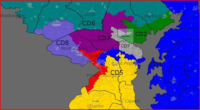
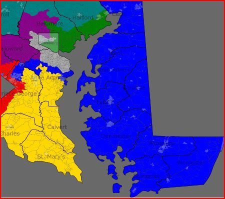
OK … this is probably my last attempt at redrawing my home state of Maryland.   I feel that this is my best plan yet.  I create eight solid Democratic districts (58% or more Obama each) while making each district as compact as possible.

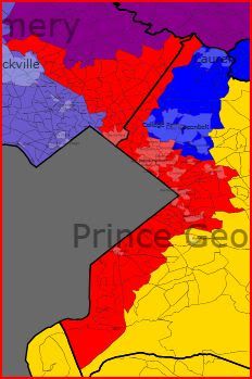
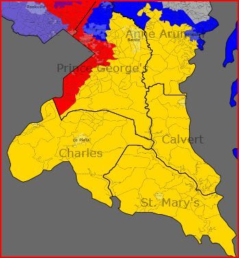
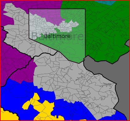
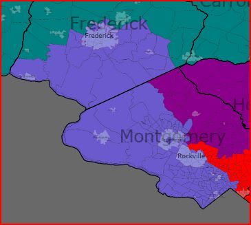
There’s just one problem — Steny Hoyer may not be happy (?).  However, the best way to get 8 Democrats out of Maryland AND to create very compact districts at the same time is to draw the map this way, where parts of the current MD-4 and MD-5 are combined.  The new MD-4 combines much of Prince George’s Co. with southern Maryland and is majority black.  It is drawn for Donna Edwards; African-Americans would comprise approximately 63% of the Democratic primary vote there (white voters about 32%).  Hoyer (who lives in St. Mary’s Co.) can move and run in the new MD-5 which includes much of northern PG Co. and northern and central Anne Arundel Co.  Northern PG was Hoyer’s home base in the past and, at one point or another in his career, Hoyer has represented about 43% of the new MD-5, so it would not be a stretch for him to run there.  The new MD-7 also remains majority black, and African-Americans would comprise approximately 60% of the Democratic primary there.   Other than Hoyer, the plan keeps the home of each incumbent in their district.  The population deviation ranges from 4 to 848 persons per district.

Maps:

Photobucket

Photobucket

Photobucket

Photobucket

Photobucket

District 1

60% Obama, 39% McCain (currently 40% Obama, 58% McCain)

61% white, 33% black

All of Eastern Shore; southern part of Anne Arundel Co.; central part of Prince George’s Co.

District 2

58% Obama, 40% McCain (currently 60% Obama, 38% McCain)

69% white, 22% black

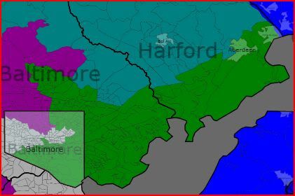
All of Harford Co.; northern part of Baltimore Co.; northern and central parts of Baltimore City

District 3

58% Obama, 41% McCain (currently 59% Obama, 39% McCain)

63% white, 25% black

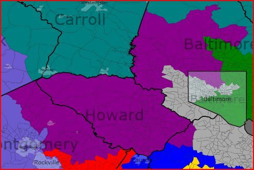
All of Howard Co. and Carroll Co.; western part of Baltimore Co.; one precinct in PG to maintain equal population of districts

District 4

75% Obama, 24% McCain (currently 85% Obama, 14% McCain)

50%+ black, 39% white

All of southern Maryland; southern and central parts of Prince George’s Co.

District 5

59% Obama, 40% McCain (currently 65% Obama, 33% McCain)

57% white, 24% black, 12% hispanic

Northern part of Prince George’s Co.; northern and central parts of Anne Arundel Co.; most of Takoma Park in Montgomery Co.

District 6

62% Obama, 36% McCain (currently 40% Obama, 58% McCain)

59% white, 15% black, 12% asian, 12% hispanic

Northern part of Montgomery Co.; northern and central parts of Frederick Co.

District 7

67% Obama, 31% McCain (currently 79% Obama, 20% McCain)

50%+ black, 44% white

Eastern part of Baltimore Co.; most of Baltimore City

District 8

61% Obama, 37% McCain (currently 74% Obama, 25% McCain)

69% white, 11% black; 10% hispanic

All of western Maryland; southern part of Frederick Co.; southern part of Montgomery Co.

(PS.  In my last diary, I indicated that I was working on a very compact plan for California in which as many Democratic districts as possible are created.  I did come up with a plan with 48 Democratic seats for the state (each district is at least 55% Obama) with very compact districts that adhere to county lines and actually have less county fragments than even the bipartisan, commission-drawn map of the 1990’s  However, I will not post my plan as I strongly believe that the resulting map is in effect a “dummymander”; 55% Obama districts are just not strong enough to assure Democratic representation in California.)  

3 VRA districts in AL, LA, and MD

I wanted to take a look at what redistricting might look like in three Southern states (Alabama, Louisiana, and Maryland) with large black populations if, within each state, three VRA districts were created. Right now, Alabama has one VRA district, Louisiana has one, and Maryland has two; this diary has maps that raise that number to three in each state. I also wanted to take a look at what the political implications of this would be on a state-by-state basis; would Democrats be hurt or helped by such plans? Please read on to find out more and leave your comments and feedback as well. Thanks!

Alabama

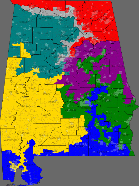
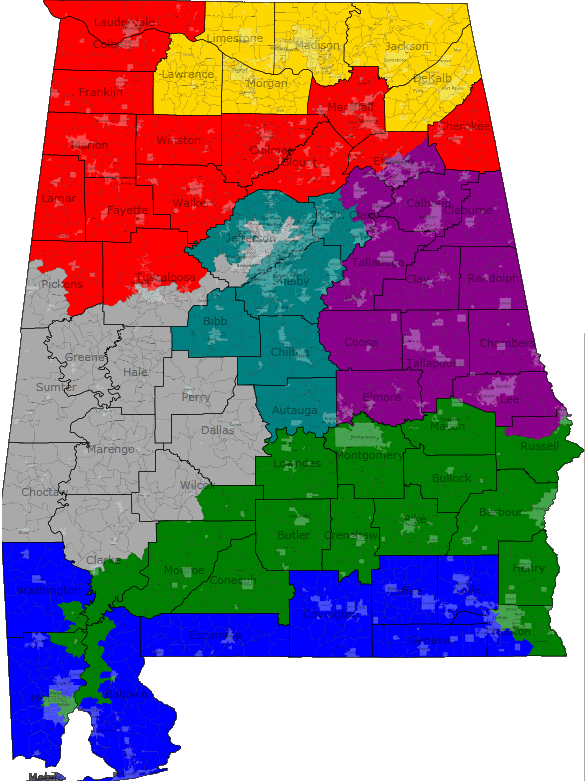
Statewide Map

District 1 (Blue): South Alabama-Mobile, Dothan, Montgomery

Demographics: 83% white, 11% black

This is a strongly Republican district that picks up the white parts of South Alabama and then snakes up north past Montgomery. Incumbent 1st district GOP Rep. Jo Bonner would easily win in this district.

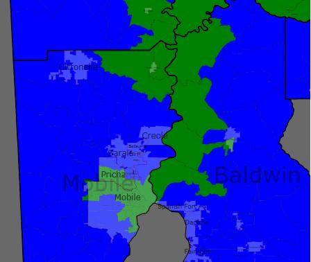
District 2 (Green): South/East Alabama-Dothan, Montgomery, Troy, Auburn

Demographics: 48% black, 48% white (black plurality)

This district picks up black areas in South Alabama and Montgomery, and then goes northward all the way to Anniston. This district should be Democratic due to a slight black plurality. While current 2nd district Democratic Rep. Bobby Bright would probably love to have a district like this, he might be vulnerable to a black challenger in a Democratic primary.

District 3 (Purple): East Alabama and Birmingham suburbs/exurbs-Birmingham

Demographics: 85% white, 10% black

This is a very Republican district that essentially combines the eastern half of the current 6th district (Birmingham suburbs and exurbs) with the mostly-white and rural northern areas of the current 3rd district. The homes of two incumbent GOP congressmen, 6th district Rep. Spencer Bacchus (from Vestavia Hills in Jefferson County) and 3rd district Rep. Mike Rogers (from Saks in Calhoun County) are both in this district so they would likely face off in a primary that I think Bacchus would be favored to win.

District 4 (Red): North Alabama-Florence, Madison, Huntsville, Albertville, Gadsden

Demographics: 87% white, 6% black

This is an extremely Republican district in North Alabama that has some of Obama’s worst areas and would be easily won by the probable congressman for the current 5th district after the 2010 elections, Republican Mo Brooks of Huntsville.

District 5 (Yellow): Southwest Alabama-Mobile, Selma, Greenville, Tuscaloosa

Demographics: 51% black, 46% white

This district takes in many of the non-Birmingham areas of the current 7th district in what is known as the Black Belt, and it now reaches down all the way into Mobile. This district has a black majority and would be an open seat almost certainly won by a black Democrat.

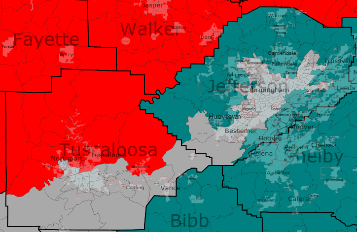
District 6 (Teal): Northwest Alabama, Birmingham suburbs/exurbs-Birmingham, Tuscaloosa, Cullman

Demographics: 88% white, 6% black

This would be a safe GOP district that merges the western halves of the current 4th and 6th districts and would likely be won by Republican Congressman Robert Aderholt, who lives in Winston County.

District 7 (Gray): Urban Birmingham and North Alabama-Birmingham, Gadsden, Huntsville, Florence

Demographics: 53% black, 41% white

This black-majority district brings the number of VRA districts in Alabama to three by picking up urban Birmingham and then snaking through North Alabama into Gadsden, Huntsville, and Florence. It will be represented by a black Democrat, probably either Teri Sewell or Shelia Smoot.

So overall, Democrats will likely gain from this map. While it essentially closes the door on ever winning any of the 4 white majority districts (all of which are now at least 85% white), it creates 3 districts that should easily fall into Democratic control, unlike the current map, which really only has one safe district for Democrats (the 7th district). So we would see a likely change from either 5R-2D (Bright wins in 2010) or 6R-1D (Bright loses in 2010) to 4R-3D.

Louisiana

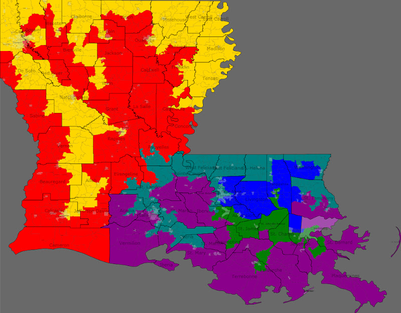
Statewide Map

District 1 (Blue): East Louisiana-Baton Rouge, Hammond, Kenner, New Orleans

Demographics: 80% white, 11% black, 6% Hispanic

This is a very conservative and Republican district that picks up white areas between New Orleans and Baton Rouge. Incumbent GOP Reps. Bill Cassidy and Steve Scalise would face off in this district’s Republican primary, and it is about half and half of each of their old districts so neither would really have the advantage of incumbency.

District 2 (Green): South Louisiana and New Orleans-New Orleans, Hammond, Houma

Demographics: 52% black, 39% white

This is essentially a successor to the current black-majority 2nd district, although it must expand south and west to make up for severe population loss from Hurricane Katrina. It retains a black majority, and will easily elect a black Democrat, probably either Cedric Richmond or Juan LaFonta, to Congress.

District 3 (Purple): South Louisiana-New Orleans, Houma, Lafayette

Demographics: 80% white, 12% black

This district has many of the white Cajun areas in the current 3rd district, but now extends to the west to pick up much of Lafayette. This district would likely elect a Republican simply due to its overwhelming whiteness, although there would be a fight in the Republican primary between Hugh Downer of Houma, who will likely be the GOP Rep. for the 3rd district following the 2010 elections, and 7th district Rep. Charles Boustany, whose Lafayette base is now in the 3rd district.

District 4 (Red): West and North Louisiana-Lake Charles, Alexandria, Shreveport, Monroe

Demographics: 82% white, 12% black

This district is intertwined with the new black-majority 5th district, taking up white areas in Western and Northern Louisiana and ending up with only 3 whole parishes, the rest of the parishes in the district being shared with neighboring districts. GOP congressmen Rodney Alexander of Alexandria and John Fleming of Minden (in Webster Parish near Shreveport) would have to battle it out in a Republican primary that Alexander would be favored to win, although either would easily hold the seat in a general election in this heavily white and Protestant district.

District 5 (Yellow): West and North Louisiana-Lake Charles, Alexandria, Nachitoches, Shreveport, Monroe

Demographics: 51% black, 45% white

This new black-majority district snakes around the Mississippi and Arkansas borders and then stretches down all the way to Lake Charles, picking up many black precincts along the way. Perhaps former Congressman Cleo Fields would give it a try in this district, although any black Democrat would be favored to win.

District 6 (Teal): East and South Louisiana-New Iberia, Lafayette, Baton Rouge, Slidell

Demographics: 52% black, 44% white

This is the third black-majority district in the state, taking the black areas of Baton Rouge and Lafayette and the snaking along the border with Mississippi and then all the way down to St. Tammany Parish. It would probably be won by a black Democrat from Baton Rouge or Lafayette.

So Louisiana is another state where Democrats would benefit from having 3 black-majority districts. The balance of power would shift from 6R-1D to 3D-3R, a three seat loss for the Republicans and a two seat gain for the Democrats.

Maryland

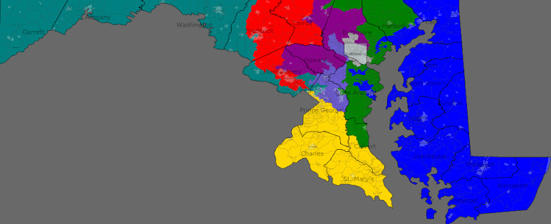
Statewide Map

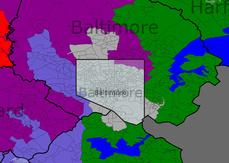
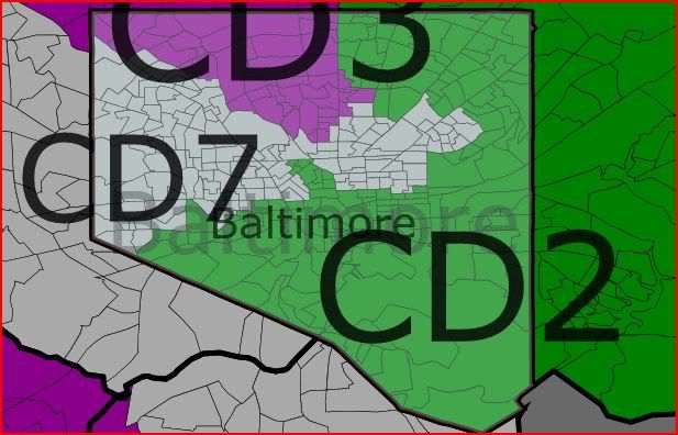
Baltimore Area Map

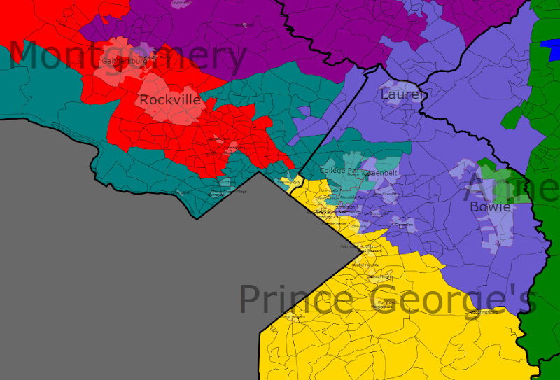
D.C. Area Map

District 1 (Blue): Eastern Shore and Baltimore, Harford, and Anne Arundel Counties-Annapolis, Aberdeen, Eaton, Salisbury

Demographics: 74% white, 19% black

2008 pres. results: 50% McCain-48% Obama

By trading heavily Republican suburban areas in Baltimore and Harford Counties with the 2nd district for Democratic areas in Baltimore and Anne Arundel Counties, this district becomes much more Democratic. While John McCain still narrowly won this district, Frank Kratovil would have no trouble winning this district as it is now mostly limited to Democratic areas and his base on the Eastern Shore.

District 2 (Green): Anne Arundel, Calvert, Harford, and Baltimore Counties-Annapolis, Bowie, Dundalk, Bel Air

Demographics: 86% white, 7% black

2008 pres. results: 59% McCain-39% Obama

This is now a heavily Republican district around Annapolis and Baltimore, a result of the creation of a third black-majority district. It was simply not possible to maintain a Democratic 2nd district and still have the three black-majority districts without threatening Democratic control of the 3rd district. As a result, this district was disproportionately packed with Republicans and gave John McCain a 20% margin of victory. We might finally say hello to Congressman Andy Harris, although he would likely be the only GOP member of Congress from Maryland.

District 3 (Purple): Baltimore, Howard, Montgomery, and Carroll Counties-Gaithersburg, Columbia, Westminster, Towson, Baltimore

Demographics: 69% white, 15% black, 8% Asian, 5% Hispanic

2008 pres. results: 56% Obama-42% McCain

This is a new district that stretches from Montgomery County all the way up to the Pennsylvania border. Both John Sarbanes and Dutch Ruppersberger would likely run in the Democratic primary in this district in order to stay in Congress, although they might split the Baltimore vote, allowing someone from Montgomery or Howard Counties to slip through. A Democrat should win here nonetheless.

District 4 (Red): Frederick, Carroll, and Montgomery Counties-Frederick, Westminster, Rockville, Gaithersburg

Demographics: 66% white, 12% Hispanic, 10% Asian, 10% black

2008 pres. results: 58% Obama-40% McCain

This map is not all bad news for Democrats, as GOP Rep. Roscoe Bartlett sees his Republican district split in half and replaced with two districts where Obama received 59% of the vote. The new 4th district combines most of the current 8th district’s portion of very Democratic Montgomery County with parts of Frederick and Carroll Counties. It has 8th district Rep. Chris Van Hollen’s home in Kensington and Van Hollen could easily defeat the very conservative Bartlett (who would also be 86 years old by Election Day 2012) in this Democratic district.

District 5 (Yellow): Montgomery, Prince George’s, Charles, Calvert, and St. Mary’s Counties-La Plata, Waldorf, Clinton

Demographics: 55% black, 33% white, 7% Hispanic

2008 pres. results: 78% Obama-21% McCain

The first of Maryland’s black majority districts, half of this super-Democratic district is made up of areas from Democratic Rep. Donna Edwards’ current 4th district and Chris Van Hollen’s 8th district, while the other half of the district comes from Democratic Rep. Steny Hoyer’s current 5th district. This new district is 56% black and contains Edwards’ base in Prince George’s County, although it also has Steny Hoyer’s base in Southern Maryland and the House Majority Leader would no doubt be difficult to topple in a primary. I think a primary would be very competitive between the two incumbents, so Edwards might decide to instead run in the new black-majority 8th district.

District 6 (Teal): Panhandle and Frederick, Montgomery, and Prince George’s Counties-Cumberland, Hagerstown, Frederick, College Park

Demographics: 65% white, 14% black, 12% Hispanic, 6% Asian

2008 pres. results: 59% Obama-39% McCain

This district is the second nail in the coffin for Roscoe Bartlett. The conservative rednecks living in the Panhandle are placed in the same district as liberal voters in Prince George’s and Montgomery Counties, and the University of Maryland’s campus in College Park is placed in the district as well. While Van Hollen’s home is in the 4th district, he could easily run here and win, even against Roscoe Bartlett. Former 8th liberal Republican Rep. Connie Morrella would have likely defeated Van Hollen here in 2002 though. I really don’t know which of these two districts Van Hollen and Bartlett would run in, but I think they would both elect Democrats.

District 7 (Gray): Baltimore City and Baltimore and Anne Arundel Counties-Baltimore

Demographics: 55% black, 38% white

2008 pres. results: 80% Obama-18%  McCain

This black-majority district takes up nearly all of Baltimore City and some surrounding areas. It is very Democratic and would retain Democratic Rep. Elijah Cummings as its representative.

District 8 (Lavender): Baltimore City and Baltimore, Howard, Anne Arundel, Prince George’s, and Montgomery Counties-Baltimore, Columbia, Laurel, Bowie, Greenbelt

Demographics: 55% black, 29% white, 8% Hispanic, 6% Asian

2008 pres. results: 84% Obama-15% McCain

This is the third black-majority district in the state as well as Obama’s best district, picking up black areas in between Prince George’s County and Baltimore. While Democratic Rep. Donna Edwards might choose to run here rather than face Steny Hoyer in a primary, it would likely be an open seat won by a black Democrat.

So it is definitely possible to make three black-majority districts in Maryland. However, would this plan necessarily result in three black representatives being elected? Districts 7 and 8 would easily elect black congressmen, although Steny Hoyer might continue to win in the 5th district despite its new black-majority due to significant establishment support. The three black-majority districts are not an obstacle to toppling Roscoe Bartlett, although they must sacrifice either John Sarbanes or Dutch Ruppersberger. The change after redistricting would be minimal, going from a 7D-1R (Kratovil wins in 2010) or 6D-2R (Kratovil loses in 2010) split to a probable 7D-1R split (assuming Kratovil wins the 1st district seat). Despite the lack of a change in partisan balance under this map, Democrats would probably want to avoid forcing Hoyer into a tough primary and losing Sarbanes or Ruppersberger, so this is one state where three black-majority districts would be a bad thing for Democrats.

Thanks for reading and please leave your comments and feedback!

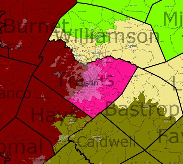
Redistricting Alabama: Two VRA Districts

There are a few scenarios which could give rise to this map. If control of redistricting is split, then I could see this as a compromise map. As you'll soon see, Mike Rogers' life gets easier while the Second District becomes solidly Democratic (albeit with Bobby Bright is serious trouble in the primary, assuming he's still around).

 Even if Democrats have the redistricting trifecta, the fact that only one of the state's seven districts can be counted on to go Democratic and only one another saw Obama get more than 40% of the vote has got to be worrisome. So, a map such as this can also be seen as a Democratic gerrymander of sorts in that it makes two solidly Democratic districts.

I could even see this as a Republican map, especially if Bobby Bright survives. If that happens, they could concede the Second in return for shoring up their most vulnerable member: Mike Rogers.

Finally, this map could result from a decision by the courts or the Justice Department mandating that Alabama have another black-majority district. 2005 Census estimates put Alabama at 26.7% black. That amounts to just under two districts, and considering that adding another majority black district to Alabama is fairly easy as the heavily black areas tend to be clustered or at least fairly close to each other.

State Map


First District (Blue)
Old District: 67.8% white | 28% black
Old Demographics: 82% white | 13% black
New Demographics: 81% white | 13% black

The First exchanges heavily black areas in Mobile for rural, white areas along the Florida border. The net result is a significantly whiter and probably more Republican district, as if Jo Bonner needed it.  

Second District (Green)
Old District: 67% white | 29% black
Old Demographics: 44% white | 53% black
New Demographics: 41% white | 55% black

Previous attempts to move the black areas of Mobile to the Seventh District and move extra black areas from the Seventh to the Second were unsuccessful as it left the First and Second underpopulated with nowhere to gain that wouldn’t negate the whole purpose. But moving this area into the Second does work. The Second also picks up heavily black areas from the Seventh and Third and loses whiter areas to the First and Third. As a result, the district is now majority black and, I would assume, pretty solidly Democratic. Bobby Bright would likely have trouble in the primary, though.

Third District (Purple)
Old District: 65% white | 32% black
Old Demographics: 74% white | 22% black
New Demographics: 73% white | 23% black

Things get easier for Mike Rogers. Not only has the district been pushed northward out of the black belt (or at least the blackest parts of it), becoming almost three-quarters white, but Rogers' Democratic opponent Josh Segall is now in the Second District.

Fourth District (Red)
Old District: 90% white | 5% black
Old Demographics: 90% white | 6% black
New Demographics: 88% white | 6% black

The Fourth remains Alabama's whitest and least diverse districts. I tried to make it a heavily rural district, which you may can see in its loss of Fort Payne and Gadsden. That effort may have been futile as I had to put Florence and parts of Tuscaloosa in the district. I would be shocked if Rob Aderholt had any problems here.

Fifth District (Yellow)
Old District: 78% white | 17% black
Old Demographics: 79% white | 15% black
New Demographics: 76% white | 16% black

With this one, I tried to make it more urban (or at least less rural) as well as concentrate the military interests in one district. The new Fifth picks of Decatur and Fort Payne, among other areas, and sheds some more rural areas.

Sixth District (Teal)
Old District: 89% white | 8% black
Old Demographics: 88% white | 8% black
New Demographics: 85% white | 10% black

With the loss of Tuscaloosa County, the Sixth loses much of its former serpentine shape. With the addition of Autauga County, the district becomes more of a Birmingham to Montgomery district.

Seventh District (Gray)
Old District: 36% white | 62% black
Old Demographics: 37% white | 60% black
New Demographics: 35% white | 61% black

Not a whole lot has changed here. It loses some of Clarke County, giving the district a more compact look, as well as parts of Pickens and Wilcox Counties. In return, it gains some Birmingham-area precincts. The story is still the same: heavily black and solidly Democratic.

Redrawing Maryland: Congressional and Legislative Districts

The following is my latest attempt to draw new district lines for Maryland.  Lately, I have thought about this and have tried to find a way to reconcile my desire for more Democrats with the idea that districts should nevertheless adhere to some form of geographic “coherence”.  The goal of this diary is therefore to create cleaner lines for both Congressional and Legislative Districts in Maryland, while at the same time, increasing the number of Democratic representatives.

I am also working on yet another plan for California, using the same goals as for Maryland above.  Due to work and family responsibilities, it may be a while though before it’s ready … so for now, here’s my home state Maryland:

Congressional Districts

I have previously worked with the idea of eight Democratic seats for Maryland:

http://www.swingstateproject.c…

and …  http://www.swingstateproject.c…

Although, you can indeed create plans for the state where each of the eight districts is at least 58-59% Obama (while preserving the two black-majority districts), the resulting maps seem just way too convoluted to me in retrospect …

In my new plan here, I create seven solid Democratic districts (60% or more Obama each) while trying to preserve relatively neat lines.  I tried to break up as few counties as possible, and, as you can see, the resulting lines certainly look cleaner than the current map.  Under the current map, there are 40 “county-fragments” in the Maryland congressional map (for example, Anne Arundel Co. has 4 “county-fragments”: parts of Districts 1, 2, 3 and 5), while under the proposed plan here that number declines to 36 “county-fragments.”  More importantly, the new districts overall look a lot less gerrymandered and a lot more compact than the current map.

I also tried to ensure that MD-7 is at least 55% black (not just 50%+) to ensure continued African-American representation.  MD-4, on the other hand, is made to be only 50%+ black; that district is much more diverse (only 23% white under the new lines, compared to 39% for the new MD-7), and more Democratic (85% Obama under the new lines, compared to 72% Obama for the new MD-7), so 50%+ black is really all that’s needed for MD-4.

For the two most “high-profile” Maryland Congressmen, Hoyer and Van Hollen, I drew the districts to be 65% Obama, while for Ruppersberger and Sarbanes, they will be 61% Obama (this is still higher than the current Obama percentages for both MD-2 and MD-3).  I also have a hunch that Hoyer may like his new district more than his current one; the new district is just as Democratic as the current one, but the black percentage goes down from 34% to 29% thereby lessening a serious Democratic primary challenge to Hoyer in the future.

I tried to ensure that at least 50% of each new district’s population is made up out of current constituents in that district.  Indeed, in 4 of the 8 districts (MD-2, MD-5, MD-6 and MD-8) at least 68% of the new population is the same as in the current district.  In MD-1 and MD-4, around 60% are transferred.  In MD-3, Sarbanes gets to keep 55% of his constituents. In MD-7 Cummings gets to keep a bit over 50% of his constituents, although this percentage does not include large swaths of the city that are African-American, but which are part of MD-2 under the current lines (all in all, the lines in Baltimore City looks very compact compared to the current plan).

The new MD-1 includes all of the Eastern Shore, but the Democratic percentage still shoots up to 60% Obama, with the addition of hyper-Democratic areas on the western shore.  MD-6 preserves the three Western Maryland Counties (though Bartlett’s home area in Frederick is no longer in the district), and becomes a 63% McCain district.

The plan preserves the hometowns of each of Maryland’s seven Democratic incumbents in their respective districts.  The population deviation for my map ranges from +/- 224 to 859 persons per district.

Photobucket

Photobucket

Photobucket

Photobucket

Photobucket

District 1

60% Obama, 38% McCain (currently 40% Obama, 58% McCain)

60% white, 33% black

All of Eastern Shore; southern part of Anne Arundel Co. including part of Annapolis; central and eastern parts of Prince George’s Co. including Upper Marlboro, Largo/Kettering, Mitchellville, Lanham/Seabrook, New Carrollton, Glenarden, Landover Hills and part of Bowie.

The Democratic percentage here surges under this remap.  At one moment, I looked at the new district and thought “Michael Steele”.  However, the district is 60% Obama, and as demonstrated by Davis v. Sparks in the recent Alabama Governor’s primary, African-Americans vote based on the issues and not race.  (Btw, Steele only managed to get 15-17% of the black vote in Maryland in 2006 — and not 25% as some exit polls indicated — and his “reputation” with black and Democratic voters has since then deteriorated; I honestly think he’d be lucky if he got 10% of the Maryland black vote these days.)  And besides, in a Kratovil vs. Steele matchup (if Kratovil survives 2010), Kratovil would still have the home-turf advantage of representing the Shore (59% of the district). So, bottom line, I’m not too worried about Steele.

District 2

61% Obama, 37% McCain (currently 60% Obama, 38% McCain)

64% white, 26% black

Parts of Baltimore City; part of Baltimore Co. including Cockeysville, Timonium/Lutherville, Carney, Rosedale, Dundalk, Essex, Middle River, Catonsville, Randallstown, Reisterstown, Owings Mills; southern part of Harford Co. including Edgewood, Joppatowne, Aberdeen and Havre de Grace.  

The new district is now confined to only three counties, as the Anne Arundel Co. part is taken out, and the lines look a lot cleaner.  Many black precincts in Baltimore City are taken out and attached to the new MD-7, but to compensate, progressive white areas (Charles Village, for ex.) in the city are added, as well as some very Democratic areas in the western part of Baltimore County — the end result is that the Democratic percentage actually goes up slightly.  69% of the new district’s residents are current Ruppersberger constituents.

District 3

61% Obama, 37% McCain (currently 59% Obama, 39% McCain)

65% white, 21% black, 7% asian, 5% hispanic

All of Howard Co.; part of Baltimore City.; part of Baltimore Co. including Towson, Pikesville, Woodlawn/Lochearn, Arbutus and Halethorpe; part of Anne Arundel Co. including Glen Burnie, Brooklyn Park, Linthicum, Severn, Fort Meade, Odenton and Crofton.  

The new district is a lot more compact than the current one, and the Democratic percentage goes up a few points.

District 4

85% Obama, 14% McCain (currently 85% Obama, 14% McCain)

50%+ black, 23% white, 17% hispanic, 8% asian

Parts of inner Prince George’s Co. including Fort Washington, Oxon Hill, Forest Heights, Temple Hills, District Heights, Forestville, Suitland, Seat Pleasant, Capitol Heights, Cheverly, Brentwood, Mount Rainier, Hyattsville/Chillum, Adelphi, Langley Park, parts of central and eastern Montgomery Co. (including the greater Silver Spring area, Derwood and Washington Grove).  

The lines are changed somewhat, but Donna Edwards still gets to keep 61% of her current constituents and the hyper-Democratic nature of the district does not change at all (this is my home district, btw !).

District 5

65% Obama, 34% McCain (currently 65% Obama, 33% McCain)

55% white, 29% black, 8% hispanic, 5% asian

All of Southern Maryland (Calvert, St. Mary’s and Charles Counties); parts of Prince George’s Co. including Bladensburg, Riverdale, University Park, College Park, Berwyn Heights, Greenbelt, Beltsville, Laurel and part of Bowie; part of northern Montgomery Co.  

Hoyer gets to keep 68% of his current constituents.  Like I already mentioned, Hoyer may like this district more than his current one because of the decreased likelihood of a Democratic primary challenge — the current MD-5 is 34% black while the new one is 29% black (blacks as a percentage of the Democratic primary vote probably approach 50% under the current lines).

District 6

35% Obama, 63% McCain (currently 40% Obama, 58% McCain)

90% white, 5% black

All of Western Maryland (Garrett, Allegany and Washington Counties); all of Carroll Co.; northern part of Baltimore Co.; central and northern parts of Harford Co. including Bel Air area; northernmost sliver of Frederick Co. around Emmitsburg.

District 7

72% Obama, 27% McCain (currently 79% Obama, 20% McCain)

55% black, 39% white

Most of Baltimore City, part of Anne Arundel Co. including Pasadena, Severna Park, Arnold, Millersville, Davidsonville and the Annapolis area.

The new MD-7 combines the most Democratic and African-American parts of Baltimore City with some of the most Republican parts of Anne Arundel County.  Blacks comprise 55% of the electorate here, but likely a much higher percentage (about 70-75%) of the Democratic primary electorate.

District 8

65% Obama, 34% McCain (currently 74% Obama, 25% McCain)

65% white, 12% hispanic, 11% asian, 10% black

Parts of central and southern Montgomery Co. including Rockville, Gaithersburg, Wheaton, Takoma Park, Chevy Chase, Kensington, Bethesda and Potomac; most of Frederick Co.  

Van Hollen gets to keep 69% of his current constituents.  The Democratic percentage declines from 74% Obama to 65% Obama, but Van Hollen or any other competent Democrat should win easily here.  If Connie Morella ran under these lines in 2002, she might have won, but a lot has changed over the last eight years in terms of political preferences and voting patterns in this area.

Legislative Districts

Now, on to the Legislative Districts map.

Each legislative district in Maryland elects one Senator and three Delegates.  In most districts, the three Delegates are elected at large from the whole district, while in some areas the districts are divided into sub-districts (generally in more sparsely populated areas of the state, or when a sub-district is created to provide a better opportunity for minority population representation).  The sub-districts can be of two types: 1) three one-Delegate sub-districts — like District 1 in the plan below, or 2.) one two-Delegate sub-district combined with one one-Delegate sub-district — like District 11 in the plan below.

A while back, I took a whack at this:

http://www.swingstateproject.c…

However, I still feel that the lines can be more refined.  My goal here was to create more Democratic seats, while at the same time making the lines cleaner.  Under the current map, there are 85 “county-fragments” in the Maryland legislative map (for example, Anne Arundel Co. has 6 “county-fragments”: Districts 30, 31, 32, 33-A, 33-B, and part of District 21), while under the proposed plan here that number declines to 73 “county-fragments.”

The population deviation for my map ranges from +/- 1,900 persons per district.  Sorry if some of the information here is a rehash from my earlier diary on redrawing Maryland’s legislative lines, but there are also some significant changes here from that earlier attempt.

The bottom line for this plan is that two Democratic Senators and six Democratic Delegates (in Districts 9 and 31) are likely to be added to the Maryland Legislature under the new lines, while an additional two Democratic Senators and six Democratic Delegates (in various districts — discussed below) may possibly be added (those numbers factor in the possible loss of several Democratic Delegates in District 34).  Also, up to eighteen current Democratic representatives in marginal seats are given stronger Democratic districts.

So, all in all, a potential gain of sixteen Democratic representatives for the next decade, as well as eighteen current Democrats made stronger.

Also, up to six  black representatives and three Hispanic representatives may be added to the state’s delegation under the plan.  Overall, eight new minority-majority districts are created (even though a number of those in Montgomery Co. have no single dominant ethnic/racial minority group).

Photobucket

Photobucket

Photobucket

Photobucket

Photobucket

Photobucket

Photobucket

Photobucket

Photobucket

District 1 – Western Maryland

New district: 93% white; 33% Obama (current district 32% Obama)

The only real change here is to divide into sub-districts a little differently from the current map:

1A – Garrett County, part of Allegany; 98% white; 28% Obama (current district 27% Obama)

1B – Frostburg and Cumberland; 89% white; 7% black; 40% Obama (current district 34% Obama)

1C – parts of Allegany and Washington Counties; 93% white; 31% Obama (current district 36% Obama)

I am not sure why the sub-districts are currently drawn as they are.  This re-drawing should shore up the one Democratic representative in this whole district, Kevin Kelly of 1B; his redrawn district will now include most of Cumberland and will be about 6 percentage points more Democratic than before.

District 2 – Washington County

New district: 83% white; 12% black; 45% Obama (Obama percentage is same as in current district)

No major changes here except to reconfigure the sub-districts.  Instead of three sub-districts, the new plan has only two:

2A – Hagerstown; 79% white; 13% black; one Delegate; 57% Obama

2B – more rural remainder of District 2; 84% white; 11% black (about 45% of the black population in this district is in the state prison located here); two Delegates; 40% Obama

District 3 – City of Frederick and southern Frederick County

New district: 71% white; 14% black; 8% hispanic; 5% asian; 56% Obama (current district 54% Obama)

The major change here is to get rid of the sub-districts.  A district that is 56% Obama (and becoming more Democratic as time goes on as more people from outside Frederick Co. stream in) should be able to elect three Democratic Delegates, instead of the current two in 3A (City of Frederick) and the Republican-turned-Independent in 3B (southern Frederick Co.).  Right-wing GOP Senator Alex Mooney may be on the way out in the November election (he won in 2006 with only 52% of the vote, and this district has experienced an influx of less conservative people moving in since then); the increase in the Democratic percentage (from 54% to 56% Obama) should help also once the new lines are in place in 2012.

Bottom line for District 3: Possible addition of Democratic Senator (if the incumbent survives 2010) and one Democratic Delegate.


District 4
– Frederick County, parts of Washington and Carroll Counties

New district: 91% white; 38% Obama (current district 37% Obama)

The sub-districts are eliminated and the new District 4 is now confined mostly to Frederick County (previously about one-third of the district was in Carroll Co.)   The only areas outside the county (necessary to preserve equal population of the district) will be Smithsburg in Washington Co. and Mt. Airy which straddles the Carroll Co./Frederick Co. line.  The GOP is expected to dominate here.

District 5 – Carroll County

New district: 92% white; 32% Obama (current district 33% Obama)

Like with District 4, the sub-districts are eliminated and the district will now be completely confined to Carroll County, instead of stretching out into northern Baltimore County.  GOP stronghold.

District 6 – Dundalk, Sparrows Point, parts of eastern Baltimore City

New district: 68% white; 27% black; 55% Obama (current district 45% Obama)

This area is a traditional blue-collar Democratic stronghold that has shifted to the right over the decades (your quintessential Reagan Democrat country).  The current District 6 is the only district in the state of Maryland (out of 47) where John Kerry performed better than Obama.  Democrats still win here locally, but in order to make the district safer for the future, the Democratic percentage is increased by 10 percentage points.  This is done in tandem with combining parts of eastern Baltimore City with the Baltimore County portion of the district.  

It should be noted that the break-down here is almost exactly such that the Baltimore City portion could be made into a sub-district electing one Delegate (the new Delegate would likely be an African-American Democrat, as that part is 61% black and voted 90% for Obama) while the Baltimore Co. part could be a two-Delegate sub-district.  However, such a move might be politically risky.  The Baltimore Co. part voted only 41% Obama and could realistically elect two Republicans at some point in the future if made into a sub-district.  Therefore, I am keeping the new District 6 without sub-districts.

District 7 – northern Baltimore County

New district: 88% white; 5% black; 36% Obama (current district 39% Obama)

The new district combines most current areas of the district with territory in northern-most Baltimore Co. which was previously part of District 5.  The new district will now be confined entirely within Baltimore Co. (it currently stretches into Harford) and it becomes even more Republican than the current form.

District 8 – Parkville, Overlea, Rosedale, White Marsh

New district: 71% white; 19% black; 5% asian; 52% Obama (current district 48% Obama)

The current district is represented by a Democratic Senator, two Democratic Delegates and one Republican Delegate.  The Republican won by a smidge last time, and the increase in the Democratic percentage (48% Obama to 52% Obama) should help here.

Bottom line for District 8: Possible addition of one Democratic Delegate, and the existing Democratic representatives are made stronger.

District 9 – Howard County (Ellicott City, most of Columbia)

New district: 62% white; 16% black; 14% Asian; 5% hispanic; 61% Obama (current district 43% Obama)

The new District 9 is a really good example of how you can make a district more compact, yet more Democratic at the same time.  The current district stretches across Howard and Carroll Counties and is quite Republican.  The new district is confined entirely to Howard Co. and is a lot more Democratic.

Bottom line for District 9: Very probable addition of Democratic Senator and three Democratic Delegates (the current Senator is Allan Kittleman, minority (GOP) leader).

District 10 – parts of Baltimore Co. (Milford Mill, Lochearn, Randallstown) and Carroll Co. (Eldersburg)

New district: 52% black; 41% white; 66% Obama (current district 87% Obama)

The new district stretches along the Liberty Road corridor from just outside the Baltimore City line into Carroll County.  The district is assured of continuing to elect an all African-American Democratic delegation as approximately 70-75% of the Democratic primary vote here is black, and the district overall is about two-thirds Democratic.

District 11 – northwestern Baltimore County

New district: 54% white; 37% black; 70% Obama (current district 66% Obama)

Remains solidly Democratic.  I have divided the new district into two sub-districts:

11A – one-Delegate district; area between Pikesville, Reisterstown and Mays Chapel; 80% white; 11% black; 5% asian; 55% Obama

11B – two-Delegate district; parts of Randallstown, Reisterstown and Owings Mills; 50%+ black; 40% white; 80% Obama

The creation of sub-district 11B will likely add two African-American legislators to the state’s delegation.  In the meantime, because of the way the lines are drawn, one or two of the current three Delegates here could run in the new District 42 which now will include a substantial part of Pikesville.  The 55% Obama percentage in 11A should not be a concern, as this is a safe Democratic district, particularly on the local level.  (John Kerry actually did better than Obama in several precincts of the new 11A, so Obama’s 55% percentage is not some sort of Democratic “ceiling” for the area, as it would be in other districts.)

Bottom line for District 11: Probable addition of two African-American Delegates.


District 12
– southwestern Baltimore County (Arbutus, Halethorpe, Catonsville, Woodlawn); part of eastern Howard County

New district: 65% white; 24% black; 6% asian; 58% Obama (same as current district)

The new district covers much of the same area as the current configuration.  The major difference is that a progressive part of Columbia (what’s now sub-district 12B) is taken out.  To compensate, most of majority black Woodlawn is added and the district’s partisan make-up remains unchanged.

District 13 – Howard County (Savage, North Laurel, part of Columbia)

New district: 63% white; 19% black; 10% asian; 5% hispanic; 62% Obama (current district 65% Obama)

This district stays quite similar to the current configuration.  District 13 was represented in the state Senate by a Republican, Sandy Schrader, prior to the 2006 election (even when the three Delegates were all Democrats).  Schrader won in 2002 with 51% of the vote, but received only 44% in her re-election attempt in 2006. This district has definitely moved in the Democratic direction over the years, and the slight decline in Democratic performance here under the proposed lines (from 65% Obama to 62% Obama) will still leave this a safe Democratic seat.

Districts 14, 15, 16, 17, 18, 19, 20 and 39 – Montgomery County

We next move to Montgomery County, where the district lines change relatively little under my map. The all-Democratic delegation here (8 Senators and 24 Delegates) is something I am very proud of (I live in Silver Spring).  I attempted to create sub-districts here which could be designed to elect minority representatives, but my efforts were futile, as the minority population is very diverse and scattered throughout the county.  Nevertheless, five of my new districts here become “minority-majority” (four are about 49% white, while District 14 is 49.6% white); District 20 is already “minority-majority”, so under this plan 6 out of 8 Montgomery Co. districts will be “minority-majority”.  This is all probably a moot issue in Montgomery, as even under the current lines, the county already has a very multi-ethnic delegation, with black, Hispanic, and Asian (east Asian, south Asian, as well as Middle Eastern-origin) representatives … and several openly gay representatives also.

New District 14: Burtonsville, Damascus, White Oak

50% white; 27% black; 13% asian; 9% hispanic; 67% Obama (current district 65% Obama)

New District 15: Potomac, Poolesville, Clarksburg

67% white; 18% asian; 7% hispanic; 7% black; 66% Obama (current district 65% Obama)

New District 16: Bethesda, Chevy Chase, Garrett Park

77% white; 10% asian; 8% hispanic; 73% Obama (current district 74% Obama)

New District 17: Rockville, Gaithersburg

49% white; 20% hispanic; 17% asian; 12% black; 71% Obama (Obama percentage is same as in current district)

New District 18: Wheaton, Derwood, Kensington, part of Silver Spring

49% white; 21% hispanic; 17% black; 11% asian; 73% Obama (current district 76% Obama)

New District 19: Aspen Hill, Leisure World, Olney, Brookeville

49% white; 19% black; 18% hispanic; 12% asian; 70% Obama (current district 68% Obama)

New District 20: Silver Spring, Takoma Park

41% white; 24% black; 22% hispanic; 11% asian; 81% Obama (current district 85% Obama)

New District 39: Germantown, Montgomery Village

49% white; 19% black; 15% asian; 15% hispanic; 71% Obama (Obama percentage is same as in current district)

The lines in Prince George’s County are reconfigured somewhat to provide more opportunities for African-American and Hispanic representatives to be elected there:

District 21 – northern Prince George’s County (Laurel, Greenbelt, Berwyn Heights, Glenarden)

New district: 53% black; 28% white; 9% hispanic; 7% asian; 84% Obama (current district 75% Obama)

The new district is now completely contained within PG Co.  I just don’t think that it makes sense to have a district stretch from College Park all the way to Odenton in Anne Arundel County (as does the current District 21).  The new district becomes majority black, and is likely to elect several African-American representatives in the future.

District 22 – northern Prince George’s County (College Park, Beltsville, New Carrollton, Landover Hills, Cheverly, Brentwood, Mount Rainier)

New district: 53% black; 23% white; 16% hispanic; 6% asian; 85% Obama (Obama percentage is same as in current district)

Senator Paul Pinsky may have no trouble getting re-elected here, but if he retires, this district is likely to elect an African-American Senator.  The new district becomes majority black, and is likely to elect several more African-American representatives in the future (currently, two of the three Delegates here are white).

District 23 – parts of Prince George’s Co. (Seat Pleasant, Capitol Heights, Upper Marlboro) and Anne Arundel Co. (Crofton, southern part of county)

New district: 51% black; 44% white; 69% Obama (current district 81% Obama)

Since this re-map made District 21 confined to PG Co., the new District 23 has to play the opposite role and reach outside PG, into Anne Arundel County.  The new district becomes majority black, and most registered Democrats here are black (as a good part of the white population in Anne Arundel is Republican).  Therefore, the district is likely to add African-Americans to its legislative delegation in the future.

Districts 24, 25, 26 – eastern, central and southern Prince George’s Co.

New District 24: Bowie; Mitchellville; Largo/Kettering; 65% black; 26% white; 85% Obama (current district 98% Obama)

New District 25: District Heights, Forestville, Suitland; 82% black; 11% white; 95% Obama (current district 96% Obama)

New District 26: Oxon Hill, Temple Hills, Fort Washington; 79% black; 11% white; 5% asian; 93% Obama (current district 94% Obama)

District 27 – Calvert County and southern Prince George’s Co.

New district: 65% white; 28% black; 61% Obama (current district 71% Obama)

The new district is more in line with using county boundaries as district boundaries than the current District 27, now taking in all of Calvert County (Calvert has experienced some of the highest population growth in the state, and will now account for about two-thirds of the new district).  The rest of the new district will be a Prince George’s Co.-based minority-majority sub-district.  Thus, the major change here is that sub-district 27A will now have one Delegate, instead of two, and 27B will have two instead of one.  

Senate Leader Mike Miller should be quite happy with the new lines, as his seat becomes more Calvert-based (his home) and it is less likely that he will be challenged in the Democratic primary by an African-American in the future.

27A – one Delegate; southern Prince George’s County and several precincts in Calvert to preserve equal population; 55% black; 38% white; 76% Obama (current sub-district is 81% Obama)

27B – two Delegates; most of Calvert Co.; 80% white; 14% black; 49% Obama (current sub-district is 47% Obama)

Even though sub-district 27B voted 49% Obama and 50% McCain, it should be noted that the current Delegate, Democrat Sue Kullen, won with 57% of the vote in 2006. Republican Anthony O’Donnell (the House minority leader from southern Calvert, currently in sub-district 29C) could also run here, but even if he were to win, his gain here would be effectively offset by his disappearance from District 29.

District 28 – Charles County

New district: 53% white; 38% black; 63% Obama (same as in current district)

The lines here change only insofar that several precincts in the eastern part of the county are taken out to preserve equal population.

District 29 – St. Mary’s County, part of Charles Co.

New district: 73% white; 20% black; 47% Obama (current district 44% Obama)

The new district is more compact than the current one.  The sub-districts are eliminated, and I’m hopefully optimistic that all three Delegates will be Democrats despite the 47% Obama – 51% McCain breakdown of the new district (currently both Delegates in 29A and 29B, which are areas almost entirely in St. Mary’s County, are Democrats elected with 65 and 64 percent of the vote; Anthony O’Donnell (GOP) won 29C — which straddles both St. Mary’s and Calvert Counties — with 60% but his sub-district becomes split in half between the new District 27 and the new District 29.)

District 30 – greater Annapolis area in Anne Arundel Co.

New district: 74% white; 16% black; 6% hispanic; 54% Obama (current district 52% Obama)

The lines here are tweaked somewhat in order to make the district a bit more Democratic. The current district is represented by a Democratic Senator and two out of three Delegates are also Democrats (including House Speaker Michael Busch).  The lone Republican, Delegate Ron George, won by 53 votes last time (or one-tenth of a percentage point), and so the change from 52% Obama to 54% Obama may be helpful in the future — assuming George makes it through 2010 under the current lines, which is not guaranteed.

Bottom line for District 30: Possible addition of one Democratic Delegate (if the sole Republican is not defeated by the time the new lines come into being).


District 31
– parts of Anne Arundel Co. (Glen Burnie, Brooklyn Park, Severn)

New district: 67% white; 21% black; 5% hispanic; 5% asian; 53% Obama (current district 40% Obama)

The political composition of this Anne Arundel district changes significantly under this re-map.  Most of the Glen Burnie parts currently in District 32 are added — so that Glen Burnie will now be basically all in one district instead of being split in half between Districts 31 and 32 — while most of hyper-Republican Pasadena is detached.  The result is a district that goes from 40% Obama to 53% Obama.  

It is quite likely that all four Republican representatives will disappear under the new lines, and will be replaced by four Democrats.  The GOP Senator here, Bob Jones University graduate Bryan Simonaire, won last time with only 51% of the vote, and he lives in Pasadena, now outside the district.  The three GOP Delegates all won by relatively small margins also, and two of the three also live in Pasadena.  

The one Delegate whose home remains in the new 31st is Don Dwyer, a rabidly right-wing homophobe who makes Simonaire appear like a moderate in comparison (Dwyer is so right-wing that he has effectively taken himself out of the Republican caucus, as they are apparently not conservative enough for him, though he remains a Republican.)  Dwyer won re-election by 25 votes last time (even the current 58% McCain district had barely the stomach for him), and it’s far from assured that he will win in 2010.  If he does make it this coming November, the new lines and district composition will pose a very formidable obstacle for him in 2014.  

This area is traditionally quite Democratic, but parts contain many conservative Reagan Democrats.  In that light, the 53% Obama of the proposed District 31 should not be seen as a Democratic ceiling for the district. (Disclosure: I grew up in Brooklyn Park, and my mom still lives there, hence this long entry re. District 31 … that, and the fact that the odious Don Dwyer is still a representative there.)

Bottom line for District 31: Probable addition of Democratic Senator and three Democratic Delegates.  Several of the current District 32 Democratic representatives live in what under this remap becomes part of District 31, so they can run here, while new Democrats can be elected in the new 32nd.

District 32 – parts of Anne Arundel Co. (Linthicum, Ferndale, Odenton, Fort Meade, Maryland City), part of  Howard Co. (Elkridge)

New district: 64% white; 22% black; 6% hispanic; 6% asian; 54% Obama (Obama percentage is same as in current district)

Like the current incarnation, the new district encompasses much of northwestern Anne Arundel County.  The district also crosses over into a part of Howard County, in order to maintain equal population.  


District 33
– parts of Anne Arundel Co. (Pasadena/Lake Shore, Severna Park, Millersville, Gambrills, Davidsonville)

New district: 88% white; 5% black; 36% Obama (current district 43% Obama)

The new District 33 combines the most Republican communities of Anne Arundel County into one district.  The two current sub-districts are eliminated.  GOP representatives from both the current 33rd and the current 31st are all put together into this district.

District 34 – parts of Harford and Cecil Counties

New district: 88% white; 7% black; 39% Obama (current district 48% Obama)

The new district becomes considerably less Democratic.  This is the only such occurrence under this plan where existing Democrats may be endangered because of the remap, but it is the price to pay for relatively high growth in this part of the state.  There’s not much that can be done geographically to shore up Democrats here, as the district is “tucked” into a corner of the state; nevertheless, I did manage to create a new Democratic-leaning District 46 — discussed later — out of the southern portion of the current District 34; the downside is that what remains in District 34 is less Democratic.  The current political balance here is a GOP Senator, and three Democratic Delegates.  I have redrawn the sub-districts so that they correspond to county lines (a two-delegate sub-district for Cecil, and a one-delegate sub-district for Harford):

34A – one-Delegate district; Harford Co.; 86% white; 8% black; 37% Obama

34B – two-Delegate district; Cecil Co.; 89% white; 6% black; 41% Obama

District 35 – Harford County, including Bel Air area

New district: 92% white; 31% Obama (same as in current district)

Remains somewhat similar to the current district which is a GOP stronghold; the sub-districts are eliminated.

District 36 – Upper Eastern Shore (all of Kent, Queen Anne’s and Caroline Counties and part of Cecil Co.)

New district: 85% white; 10% black; 39% Obama (current district 41% Obama)

District 37 – Lower Eastern Shore (all of Talbot, Dorchester and Somerset Counties and part of Wicomico Co.)

New District: 64% white; 31% black; 48% Obama (current district 46% Obama)

Currently, three out of four representatives here are Republicans.  Under the new lines, the district becomes 48% Obama – 51% McCain.

37A – one Delegate; Salisbury and Princess Anne areas; 54% black; 40% white; 59% Obama; the sub-district remains black-majority, but the lines look cleaner than under the current map; the sub-district should continue to elect an African-American Democrat.

37B – two Delegates; all of Talbot and Dorchester, and part of Somerset; 75% white; 20% black; 43% Obama.

District 38 – Lower Eastern Shore (all of Worcester Co., and part of Wicomico Co.)

New District: 81% white; 14% black; 43% Obama (current district 41% Obama)

The new 38th is quite similar to the current district (but without the sub-districts).  The district here currently elects a GOP Senator and GOP Delegate in sub-district 38A, while 38B elects two Democrats, even though that area is even more Republican than 38A.  The two Democrats include one legislator from Salisbury and a former mayor of Ocean City, so personal popularity likely plays a part, especially in the case of the latter.  The remap eliminates the sub-districts, while the Democratic percentage goes up a bit overall, but the political consequences remain anyone’s guess.

District 39 – see earlier entry under Districts 14, 15, etc. (Montgomery County)

Districts 40, 41, 43, 44, 45 – Baltimore City

Due to stagnant population growth, Baltimore City has to lose one of its current districts, and the 46th is the only logical candidate.  (Also, as already discussed, the eastern-most part of the city will be combined with adjoining parts of Baltimore County into a new 6th District.)  The other five districts are reconfigured but still keep the basic shape and identity of their current incarnations (I intentionally keep each district at 63-64% African-American):

New District 40: west-central Baltimore

64% black; 29% white; 90% Obama (current district 93% Obama)

New District 41: northwest Baltimore

63% black; 33% white; 86% Obama (current district 87% Obama)

New District 43: northeast Baltimore

63% black; 31% white; 89% Obama (current district 91% Obama)

New District 44: southwest and south Baltimore

63% black; 33% white; 86% Obama (current district 92% Obama)

New District 45: east-central Baltimore

63% black; 28% white; 84% Obama (current district 90% Obama)

District 42 – Towson, Timonium, Cockeysville, Pikesville, Carney

New District: 77% white; 11% black; 7% asian; 54% Obama (current district 53% Obama)

The current district is represented in the Senate by a Democrat.  However, two out of three Delegates are Republicans.  The trick in this part of central Baltimore Co. was to make District 8 somewhat more Democratic, without making District 42 less Democratic.  Therefore, the new District 42 was expanded into more Democratic areas around Pikesville.  Both Republican delegates won here by small margins last time, and the 54% Obama percentage should not necessarily be seen as a Democratic ceiling (in a couple of precincts in Pikesville Kerry actually performed better than Obama), so this district may provide good Democratic pick-up opportunities in the future.

District 46 – parts of Baltimore Co. (Middle River, part of Essex) and southern part of Harford Co. (Edgewood, Joppatowne, Aberdeen, Havre de Grace)

New District: 64% white; 27% black; 54% Obama

This district is a newly-created one to account for population growth in the area (and it replaces the old 46th which was based in Baltimore City).  It was initially surprising to me that you could create a new, compact district here that is at the same time quite Democratic.  I was afraid that the new district would have to be a GOP stronghold, thus causing an automatic loss of a Democratic Senator and three Democratic Delegates.  But there is apparently a robust Democratic presence in this area. Interestingly, the Harford Co. part of the district voted 56% Obama – 42% McCain, while the Baltimore Co. part split 49% – 49%.

District 47 – parts of northern Prince George’s County (Hyattsville/Chillum, Adelphi, Langley Park, Riverdale, Edmonston, Bladensburg, University Park)

New District: 47% hispanic; 36% black, 11% white; 87% Obama (current district 92% Obama)

I tried to create a Hispanic-majority district here, but that is basically not possible unless you cross county lines to encompass a couple precincts in Montgomery Co. (you can thus create a 51% Hispanic district in Maryland).  Since my goal was to split as few counties as possible, I instead created an all-Prince George’s Co. seat that has a  47% Hispanic plurality and may become hispanic-majority over the next decade.  The current District 47 has already elected a Delegate who is Hispanic, and this new district may help to increase Hispanic representation (Hispanics seem to be largely under-represented in the state legislature).

Redistricting Relay

[cross-posted at DLCC.org]

Late Friday afternoon, Politico’s Ken Vogel published an interesting assessment of the upcoming fight over redistricting.

“GOP lags in early redistricting race” is a broad look at the players in this year’s state-level elections and next year’s map-drawing, as well as at how those organizations fit together.

Yesterday morning's SSP Daily Digest touched on this briefly, but if you don’t have the time to peruse the three-page article at the moment (or even if you do), I thought you might enjoy some selected highlights.

Outmaneuvered by the GOP during the last round of redistricting a decade ago, Democrats appear to have an early advantage as the two parties gear up again for the expensive and high-stakes battle over redrawing state legislative and congressional districts.

“I do believe that the Democrats are much better organized at this stage,” said Ben Ginsberg, a top Republican election lawyer.

The GOP’s redistricting gains were wiped out by the electoral tidal waves that swept Democrats to power in Congress and the White House in 2006 and 2008. But Michael Sargeant, executive director of a top Democratic redistricting-related group called the Democratic Legislative Campaign Committee, said Democrats are “definitely playing catch up to Republicans as far as the maps — both at the state legislative and at the congressional level. But we’re more prepared than we were last cycle.”

[Ed] Gillespie has said he hopes to double the budget of the Republican State Leadership Committee, a 527 group formed in 2002 to help elect Republican attorneys general, lieutenant governors, secretaries of state and state lawmakers that he took over this year. With Gillespie at the helm, it absorbed the American Majority Project, and launched a reapportionment initiative called REDistricting MAjority Project or REDMAP, which is intended to target and win state legislative races that can tip the balance of legislatures that craft and vote on redistricting plans.

The Democratic Legislative Campaign Committee, a 527 run by Sargeant that was established in 1994 to help the party win state legislative seats, will target key races in an effort to protect or capture Democratic legislative majorities in states with pivotal redistricting battles.

I do recommend you read the entire article, though—it’s certainly worth the time.

At risk of being lost as a link on page two, though, is an interesting memo distributed last month to state Republican Party chairs nationwide.

The memo is written by GOP redistricting expert Dr. Thomas Hofeller and does a solid job of explaining why the state-level 2010 elections are vital and articulating what the stakes are in each state (with pictures!).

A money quote (replace “GOP” with “Democrats,” and the argument remains the same):

Why are these state-level contests so important to the GOP? It is because it is in the states where the results of the 2010 census will be used to redraw the boundaries of congressional districts which will be used in the 2012, 2014, 2016, 2018 and 2020 elections. The outcome of this battle will determine the electoral playing field for the next decade.

It’s no surprise that the GOP is as acutely aware as we are of the stakes in this year’s state-level elections. The DLCC has labored tirelessly since the harsh redistricting of 2001 and has made solid gains in statehouses across the country. But we are by no means secure as we face the 2011 redistricting. One bad cycle can destroy everything we’ve accomplished, and we never forget that as we work to support and build infrastructure for local campaigns. The GOP may be “lagging” in this redistricting race, but they’re nowhere close to losing, and we have a long way to go.

SSP Daily Digest: 6/8 (Morning Edition)

  • DE-Sen: Biden alert? Dem senate candidate Chris Coons says a Biden fundraiser is “in the works.” I sure hope so! I think Coons is a sleeper candidate, and it would be ridic for Biden not to help a fellow Dem out in his own state (which is just outside of DC, anyhow).
  • NV-Sen: It may be too late to save her fricasseed campaign, but Sue Lowden has an over-the-top ad out hitting Sharron Angle for her support of a Scientology-backed plan to offer massage therapy to recovering drug addicts. Be sure to check out the cameo of a certain couch-jumping Top Gun star at about 20 seconds in.
  • NY-Sen-B: So as you know if you’re a faithful SSP reader, the state GOP put two dudes on their ballot line for the September primary: Bruce Blakeman and David Malpass. They did not include ex-Rep. Joe DioGuardi, but (and this is a big “but,” DioGuardi did score the Conservative Party’s ballot line all to himself. Though DioGuardi says he’ll try to petition his way on to the GOP ballot, Republicans don’t seem to have a lot of faith in him becoming their nominee, and they want to avoid a split ticket. So Conservative chair Mike Long got a bunch of calls asking him to bounce DioGuardi from his party’s line, but he refused, pointing out that DioGuardi got 70% of the vote at the Conservative convention. Ah, the New York GOP – still a train wreck.
  • ID-Gov: The Idaho Statesman has a pretty good profile on Dem gubernatorial nominee Keith Allred, who is running a surprisingly vigorous (and decently-funded) campaign against the not-so-hot incumbent Butch Otter. The most interesting detail is the fact that the Idaho Association of Commerce and Industry, a chamber-of-commerce-type big business lobby, is already attacking Allred – not something you usually bother doing with an un-serious candidate.
  • SC-Gov: Rudy Giuliani jumped in with a last-minute endorsement of AG Henry McMaster yesterday – though note that the unlovable loser finished sixth in the South Carolina primary in 2008. (Though Joe Lieberman reassured him that it was actually an eleventy-way tie for fifth.) And in a seriously weird last-minute desperation move, Lt. Gov. Andre Bauer released, uh, well… you’d expect me to say “released a poll,” right? Nope – he released the results of a polygraph test (!), which he claims show he had no involvement in the various Nikki Haley affair allegations. Talk about protesting a wee bit too much, huh?
  • AL-05: A douchey move from a douchey guy: Bud Cramer, the Democrat who held this seat before giving way to Parker Griffith, is not “ready to endorse any candidate for Congress” – even though, you know, we have a nominee (Steve Raby). Cramer actually pulled this same shit last cycle after he announced his retirement, dithering for several weeks before finally endorsing Griffith. Back then, Cramer suggested he might endorse a Republican – and I guess he finally got his wish when Griffith switched parties. Jesus, though – do the right thing already.
  • FL-24: Former Winter Park Commissioner Karen Diebel scored an endorsement from Mike Huckabee in her bid to become the GOP nominee against Rep. Suzanne Kosmas.
  • MA-10: Republican Jeffrey Perry has been under fire for his oversight of a police officer under his command while Perry was a police sergeant in the early 1990s. The officer, Scott Flanagan, was ultimately fired and pled guilty for illegal strip-searching a 16-year-old girl. Now, the Cape Cod Times reports that Perry’s own accounts of the incident and its aftermath are contradicted by police records from the time. In an earlier interview, Perry suggested that he had acted with alacrity in handling the situation, but now it appears he waited 24 hours to write up the officer, and almost a week to take a statement from a witness to the search.
  • NC-08: Heh, he actually went ahead and did it. Weapons-grade wingnut Tim D’Annunzio launched a defamation suit against his runoff opponent, Harold Johnson, for a “radio ad targeting D’Annunzio for his ‘life of drugs, crime and time served in prison’ and for supposedly failing to pay an employer payroll tax, having tax liens, and withholding child support.” D’Annunzio had previously threatened to sue the chair of the NC GOP, but this is so much more fun.
  • NY-13: Rep. Mike McMahon scored the endorsement of the Independence Party, which means he’ll have their ballot line in November (something he didn’t have last cycle). And while he won’t get the support Working Families Party thanks to his “no” vote on healthcare, the WFP isn’t expected to nominate any kind of challenger, so their line will likely remain blank in this race – thus avoiding a split of the left-leaning vote. A Dem primary challenge at this point also looks remote. Meanwhile, McMahon raised $140K at a fundraiser hosted by none other than Mike Bloomberg. He was also expected to take in some $90K at an Anthony Weiner event, which was also slated to feature Staten Island Borough President James Molinaro, a Conservative.
  • NY-29: Judge David Larimer of the Western District of New York ruled against Republicans who were seeking to force Gov. David Paterson to call the special election for this vacant seat earlier than November, saying Paterson was empowered to call it for the fall. An appeal to the Second Circuit is possible, but no word yet on whether one is planned.
  • VA-11: This seems really lame.
  • CA-SoS: I guess maybe we were too busy laughing when we first heard stories that Orly Taitz was running for California Secretary of State to bother writing it up… but not only is she on the ballot, the CA GOP is worried she might win the primary! She’s running against Damon Dunn, another ex-NFLer (what is with those guys running for office this year?), but Dunn’s deliberately ignored her rather than attack. The Republicans have little chance against Dem incumbent Debra Bowen, but Orly as their nominee would be a nice, months-long goiter for them to deal with.
  • Blue Dogs: I think I agree with everything Chris Bowers says in this post.
  • Games: Several folks in comments were recommending a new game called Congress Forever the other day, where you battle for control of the House and Senate. I haven’t tried it yet, but it looks like the perfect nerd timewaster.
  • Polling: Nate Silver just released the latest version of his pollster ratings, which analyzes a truly massive data set of “4,670 distinct polls from 264 distinct pollsters covering 869 distinct electoral contests” going all the way back to 1998. He lays out his methodology in a separate post, which is a must-read. Also, that gang of polling maniacs over at PPP are soliciting your votes again: The choices this time are LA, MA, PA, WA or WI.
  • Redistricting: Politico has a piece out which claims that Republicans are lagging in the race to raise money and set up legal groups to wage the coming round of redistricting battles. I’m a little skeptical, because the article says that Republicans are hurting thanks to a lack of soft money in the post-McCain Feingold world – but if anything, Dems were known as the party most dependent on soft money before campaign finance reform passed. Still, P’Co suggests that Dems are more organized because of some top-down control being exercised by the Obama political operation.
  • Redistricting Maryland, Plan A

    I’m finally publishing this; what follows is Answer Guy’s first attempt at redistricting Maryland.

    The objectives:

    Preserve the two majority-African-American districts, one based in Baltimore, the other in Prince George’s County, per Voting Rights Act requirements. Easy enough.

    Give all seven current Democratic incumbents a similar or better chance to win re-election than the current districts allow, especially in the case of MD-01. That means preserving the existing base of each incumbent as much as possible.

    Keep communities of interest together as much as possible, if not too inconsistent with the above.

    Create districts that avoid the ungainly shapes that many of the current Maryland districts have.  

    More below the fold…

    Map Overview

    State Map

    Note: Areas outside this map are in the districts you’d think they’d be in from the context.

    First District

    MD-01

    Description: All of the Eastern Shore counties – Worcester, Somerset, Wicomico, Dorchester, Talbot, Caroline, Queen Anne’s, Kent, Cecil; portions of Anne Arundel County (Annapolis, Fort Meade, portions of Odenton, East Laurel)  and northern portions (Laurel, Beltsville, College Park, Greenbelt, and New Carrollton) of Prince George’s County. Colored dark blue here.

    Incumbent: Frank Kratovil (D-Stevensville)

    (Note: Likely Republican MD-01 nominee Andrew Harris, who has at least a 50-50 chance of winning this November, doesn’t live anywhere near here, and the areas which supported him the most last time and will again this time aren’t either.)

    Map Change: This new MD-01 still includes the entire Eastern Shore of Maryland. But while the current MD-01 includes two chunks of land (one in Baltimore and Harford Counties, the other in Anne Arundel County) very heavy on Republicans; this MD-01 replaces those areas almost entirely (there are a few precincts in Anne Arundel in common) with territory very heavy on Democrats.  The Republican areas west of the bridges – which supported McCain in even higher numbers than the Eastern Shore did – got carved up. The Anne Arundel County portion got split, with most of it going to MD-07, but some portions going to MD-05. The Harford and Baltimore County portion got divided three ways, mostly into the new MD-06 but with small portions being picked up by MD-02 and MD-03.

    1st District Pop Pct Wh Bl Hisp Asn Oth Oba McC

    Shore 437958 62% 79 16 3 1 1 43 55

    Anne Arundel 132950 19% 57 29 4 8 2 62 37

    Prince George’s 133292 19% 33 43 13 9 2 82 17

    Total 704928 66 24 6 3 1 55 44

    Old District 662062 86 11 2 1 1 40 58

    Projected PVI: D+2

    The Good News:

    This is the most altered district, and by design, turning a strong Republican district into a Democratic-leaning swing district.

    This district is in a sense designed for a guy like Kratovil, who would attempt to simultaneously appeal to swing voters on the Shore to support one of their own and to the Democrats in the rest of the district. The western portion of the current 1st gave John McCain 65% of their votes; the western portion of the new 1st gave Barack Obama 68% of their votes. The Anne Arundel portion is relatively thin, mostly avoiding Republican-heavy areas in the county to reach a highly diverse and heavily Democratic chunk of northern Prince George’s County. Due to VRA compliance requirements for MD-04, this MD-01 contains only a handful of black-majority precincts (in the Landover and New Carrollton areas.) The changes would still more than double the black population of MD-01, and the Hispanic and Asian shares of the electorate also increase dramatically with the inclusion of many diverse Washington suburbs like College Park, Beltsville, Greenbelt, Laurel, and Odenton.  . Obama’s 55% showing may overstate the Democratic leanings of this district a bit – though Kratovil was able to run 10 points ahead of the national ticket at the same time, and now most of the areas that backed Harris in that contest have been removed from the district.

    It’s not guaranteed not to ever elect a Republican, but it would be very difficult for an arch-conservative of the Club For Growth variety to get elected here.

    The Less-Than-Good News:

    On the surface, the changes are pretty much all positive for Dems. However…the potential electoral dynamics change dramatically on several levels. Because I also placed a priority on not significantly endangering any of the current Democratic seats, this isn’t a strong enough Democratic electorate to get rid of a Republican who exhibits some measure of cross-party and independent appeal, particularly during a Republican-leaning election cycle. The Eastern Shore, who represent 62% of the new district’s population, still prefers Republicans more often than not, and so do parts of the Anne Arundel County portion of the district. As I said above, the 55% showing for Obama is probably not a new normal and the partisan lean would lose a few points if non-white turnout regresses to levels more commonly seen prior to 2008.  

    It’s not hard to imagine competitive Democratic primaries that pit moderates against progressives that could produce candidates that either swing voters or base voters might find unappealing. The Democrats of the current MD-01 generally lean conservative, but Democratic candidates in this MD-01 would have contend with a much more varied electorate. Kratovil, especially if he were no longer an incumbent, would almost certainly face a primary challenge from his left of some sort if he were to run here, given his voting record.  

    The Shore would dominate Republican primaries, due to the lack of registered Republicans in the rest of the new district, to a point the dynamics that produce a candidate like Andy Harris (someone with trouble appealing to Shore residents or to swing voters in general) would be unlikely to materialize. GOP candidates would mostly come from the Shore and might be able to use that to their advantage.  

    Ironically enough, Wayne Gilchrest almost certainly still be in Congress if he had this map two years ago; there’s no way a wingnut primary challenge would have succeeded, and he’d be tough to dislodge in a general election even in a good year for Democrats across the board like 2008. In a Republican year, it’s not hard to imagine some types of Republican winning here, though a guy like Harris would have no shot, and not just because it doesn’t go anywhere near where he lives.    

    Fundraising might become a higher priority, as the new district lines cut well into the very expensive Washington media market. To reach the whole district would involve using both Baltimore-based and DC-based media. The current district, by contrast, doesn’t really include much of anything that one might describe as a proper DC suburb.  

    The Bottom Line:

    In a 2012 election with Obama on the ballot, with these lines, though it’s not a slam dunk by any means, I like Team Blue’s chances, whether with Kratovil or with someone else.

    Second District

    MD-02

    Description: Contains southern portions (Edgewood, Aberdeen, and Havre de Grace) of Harford County; eastern, northeastern, and north-central portions (Dundalk, Essex, Middle River, Parkville, Timonium, and Cockeysville) of Baltimore County;  and northeast, east, central, and southern portions of Baltimore City. Colored dark green here.  

    Incumbent: C.A. Ruppersburger (D-Cockeysville)

    (Note: Likely Republican MD-01 nominee Andrew Harris lives here, though most of his State Senate constituents don’t.)

    Map Changes:

    This new MD-02 has been made much more compact. It no longer contains any portion of Anne Arundel County and doesn’t go west of Cockeysville anymore, saying goodbye to the portions of Owings Mills and Reisterstown currently within its borders.  Containing much more of Baltimore City than previous versions of the district did, it’s now the district that includes most of the areas of Baltimore of interest to tourists – Federal Hill, the Inner Harbor/Downtown, Mount Vernon, Bolton Hill, Fells Point, Canton, Greektown, and Highlandtown. It also includes a bigger chunk of Northeast Baltimore than the current version does. The whole of southeastern Baltimore County is still here, and the Harford County portion is very similar (slightly smaller) to what is in the current district.

    2nd District Pop Pct Wh Bl Hisp Asn Oth Oba McC

    Baltimore City 277202 39% 45 47 4 2 1 82 17

    Baltimore County 339213 48% 76 15 4 3 1 48 50

    Harford 88267 13% 65 26 4 2 2 55 43

    Total 704682 62 29 4 3 1 62 36

    Old District 662060 66 27 2 2 1 60 38

    Projected PVI: D+9

    The Good News:

    The addition of central Baltimore is the main reason that the new electorate moves two points to the Democrats, more than making up for the loss of some heavily Democratic northwest suburbs given to MD-03 and MD-07. This district does contain several city neighborhoods in outlying parts in northeast and far eastern Baltimore that are neither particularly liberal nor particularly Democratic, but also contains several mostly black precincts where the Republican share of the vote is in the low single digits.

    The Baltimore County portion, about half the district, was carried by McCain, but many state and local Democrats, most notably incumbent Ruppersburger, have outperformed Obama significantly in these areas, particularly the East Side, in a development widely discussed in other SSP diaries about Maryland. And while Harford County as a whole may tilt Republican, the table above shows that the section of it included in MD-02 does not.

    The Not-So-Good News:

    This district may have been carried by Bob Ehrlich in his gubernatorial race in 2002 and looks more like the district he used to represent in the 1995-2003 period than the current MD-02 does; of the six districts designed to be relatively safe for Democrats, the Republicans have a deeper bench of officeholders at the state and local level than in any of the others.  There are signs that the east side of Baltimore County might be trending away from its traditional Democratic lean. Still, it is very hard to imagine even Ehrlich or a Republican who can duplicate his appeal winning in a district where nearly 40% of the constituents are Baltimore City residents.

    As a secondary concern, this portion of Baltimore County is home to a lot of conserva-Dems who might be able to install a not-particularly-loyal Democrat into the seat in an open-seat situation if the city vote is either low or split.  

    The Bottom Line:

    Dutch Ruppersburger doesn’t really need the help, but this map gives him some anyway. You never know when a seat is going to become open. From a redrawing point of view, keeping this district out of northwest Baltimore County helped make it and MD-03 much more compact with more appealing shapes without affecting their respective partisan makeups much. It’s a set of communities that hang together pretty well. Should remain in the Democratic column.

    Third District

    MD-03

    Descriptions: Contains northern and northwest portions of Baltimore City, northern and western portions (Towson, Pikesville, Owings Mills, Reisterstown, Randallstown) of Baltimore County, all of Howard County, northwestern portions (Jessup, Hanover) of Anne Arundel County, and northeastern portions (Damascus, Laytonsville, Olney, Burtonsville) of Montgomery County. Colored purple here.

    Incumbent: John Sarbanes (D-Towson)

    Map Changes:

    These are dramatic changes as well, as the new MD-03 is mostly pushed out of Baltimore (and pushed out of downtown entirely) and Annapolis yet is still made more Democratic, mostly by adding new territory in the west via moving more into Washington suburbs.

    The seemingly arbitrary pockets of East Baltimore are gone; what remains is more cohesive and more easily definable set of northern and northwestern city neighborhoods. Roughly from east to west, they are Waverly, Charles Village, Guilford, Homeland, Roland Park, Hampden, Mt. Washington, and upper portions of Park Heights; most are predominantly white (Park Heights and Waverly are mostly black while Charles Village is one of the most integrated parts of Baltimore) and relatively liberal.

    The Baltimore County portion does contain some conservative exurban areas in northern Baltimore County (Sparks and Pheonix areas) but is concentrated mostly in more urban Towson and Pikesville. Some precincts to the west and northwest of Baltimore are instead in the black-majority MD-07, but this portion of MD-03 does contain some majority-black precincts. The Arbutus/Halethorpe/Landsdowne area in southern Baltimore County has been removed.

    Howard County, previously split with MD-07, is now included in its entirety.

    A small portion of Anne Arundel County does remain, but it now goes nowhere near Annapolis, instead staying close to the B-W Parkway.

    The addition that sticks out most is the new territory in Montgomery County, about 130K residents, mostly outer suburbanites. There are a few precincts that carry Silver Spring, Rockville or Gaithersburg addresses, but this MD-03 contains none of either of the cities of Rockville or Gaithersburg, and nothing particularly close to the core of Silver Spring, as everything here is well outside the Beltway.

    Things had to change for several reasons. One is that the population distribution in the state is shifting away from Greater Baltimore in general and Baltimore City in particular and some district based in or around Baltimore was inevitably going to end up with more Washington suburbanites. Another is that to fix the hideous shapes of some of the current districts required cutting off some of the more ungainly-looking appendages.  The current MD-03 is a group of pockets joined together by a series of thin strands and cleaning that up required shedding some of the pockets and filling out others; the threads running to the east were incompatible with the rest of the plan for the state, so the only direction to go was to the west.  

    3rd District Pop Pct Wh Bl Hisp Asn Oth Oba McC

    Baltimore City 92372 13% 61 29 3 5 1 81 17

    Baltimore County 193424 27% 66 24 3 5 1 59 39

    Howard/Arundel (Balt. Area) 167389 24% 63 18 5 12 2 59 39

    Howard West (DC Area) 120254 17% 64 17 5 11 2 63 35

    Montgomery 131144 19% 64 15 9 10 2 62 37

    Total 704583 64 20 5 9 2 63 36

    Old District 662062 77 16 3 3 1 59 39

    Projected PVI: D+10

    The Not-So-Good News:

    It’s often awkward when redistricting changes a constituency this much, even if in the abstract the changes are favorable to an incumbent seeking re-election, as they are here. At some level, this would be like an open-seat race as far as about half the electorate is concerned. It might even be more awkward than usual in this case. The table lists the different components of the district; I divided Howard County into areas likely have some connection to Baltimore (roughly anything north of Route 32 and east of Route 29) and those areas unlikely to know much about Baltimore and its politics. Throw the latter in with MoCo and that’s about 36% of the district that has no Baltimore connection. Reaching them would require investing in an expensive new media market. (Though there are already probably some residents of the current MD-03 who are better reached via Washington media than Baltimore media because Washington casts a much bigger shadow.) Incumbent John Sarbanes lives in Towson in Baltimore County and his family is based in Baltimore; though his name is well-known in the western portions of the new MD-03, he himself is not.

    The Good News:

    From Democrats’ point of view, simply put, what could have become a potential swing district in a year with low Baltimore City turnout is made four points more Democratic. These new constituents aren’t likely to vote Republican, especially compared with what else could have been placed in this district. The Republican bench here is almost entirely confined to two areas, one in western Howard County, the other in northern Baltimore County, that have little in common with the rest of the district. The main bases of the district since the ’90s have been north Baltimore, Towson, Pikesville, and Columbia, and they’re all still here.

    From Baltimore’s point of view, this is a district that even in an open-seat Democratic primary or general election is still more likely to choose a Baltimore-area representative than one from closer to DC; not only do most residents of the district live closer to Baltimore, but the DC-focused areas contain large numbers of new, less-established residents with no ties to existing political cliques. (Obviously, this isn’t good news for Montgomery County’s clout, but they’d they have no less than now.)

    From Sarbanes’ own point of view, these new areas, in addition to not being of much help to future Republican opponents, aren’t especially likely to form the base for any successful region-based (notenough of them) or ideology-based (not different enough from the rest of the district to matter) primary challenges. And any Baltimore-area politician, looking at a future statewide run is going to need to be known in MoCo.

    Bottom Line:

    This district should be safe for John Sarbanes and is unlikely to be in danger of flipping to the Republicans should he decide to move on.

    Fourth District

    MD-04

    Description: Portions of Prince George’s County (Ft. Washington, Oxon Hill, District Heights, Capitol Heights, Glenarden, Cheverly, Hyattsville, Langley Park) close to Washington, DC, and eastern and central portions (Takoma Park, East Silver Spring, Wheaton, White Oak, Burtonsville) of Montgomery County. Colored red here.

    Incumbent: Donna Edwards (D-Fort Washington)

    Map Change: This MD-04 sheds some Upper Montgomery territory to the expansion of MD-03, and cedes some of central and southern Prince George’s to MD-05. It picks up more of close-in eastern Montgomery County from MD-08 for the sake of compactness.

    4th District Pop Pct Wh Bl Hisp Asn Oth Oba McC

    Prince George’s 435116 62% 8 70 18 3 1 93 6

    Montgomery 268281 38% 38 25 21 14 2 77 21

    Total 703397 20 53 19 7 2 87 12

    Old District 662062 27 57 8 6 0 85 14

    Projected PVI: D+32

    The Good News: This version of MD-04 is even more strongly Democratic (despite reducing the African-American share of the residents from 57% to 53%) which ranks it among the most Democratic and most liberal districts in the nation.  I did not set out to strengthen the Democratic lean here, it’s a natural consequence of removing less Democratic far-flung areas like Clarksburg and making things more compact and leaving room for the MD-03 shift chronicled above. It’s interesting from a political-demography perspective; it’s not every day you can change a district’s borders to include fewer African-Americans and yet increase the Democratic share of the vote. From Edwards; perspective, the increase in the Democratic vote in Montgomery also has the effect of making a Prince George’s County-based primary challenge tougher.

    The Not-So-Good News: There are no Republican-leaning areas anywhere near here to neutralize, unless one wants push these borders way south to break up Southern Maryland or way north to get some less Democratic parts of Montgomery or Howard Counties, and I had good reasons not to do either.

    Fifth District

    MD-05

    Description: Southern and central portions (Crofton, Millersville, Davidsonville, Edgewater, Deale) of Anne Arundel County; central, western and southern portions (Bowie, Seabrook, Largo, Mitchellville, Forestville, Upper Marlboro, Brandywine, Acokeek) of Prince George’s County; all of Charles County; all of Calvert County; all of St. Mary’s County. Colored yellow here.

    Incumbent: Steny Hoyer (D-Mechanicsville)

    Projected PVI: D+12

    Map Change: Less than many districts. The new MD-05 is changed mostly to help MD-01, shedding areas in northern Prince George’s County (such as Laurel, Greenbelt, and College Park) and western and central Anne Arundel County.  It doesn’t weaken as a strong Democratic district due its new areas in central Prince George’s County left behind by MD-04, a change reflected in the demographics numbers as the proportion of African-Americans increases from 30% to 36%.

    5th District

    Anne Arundel 120226 17% 84 9 3 2 1 45 54

    Prince George’s 252444 36% 25 65 5 3 2 87 12

    Charles 140764 20% 52 39 4 2 2 64 35

    St. Mary’s/Calvert 190276 27% 79 15 3 2 2 45 54

    Total 703710 55 36 4 3 2 66 33

    Old District 662060 60 30 4 4 0 65 33

    The Good News:

    A reasonably safe Democratic district (at least by 2008 metrics) moves one more point in that direction. Southern Maryland is kept together as a unit. From a pro-diversity point of view, an African-American would have a decent shot in an open seat Democratic primary here, more so than the currently existing MD-05. Though there is a reasonable Republican farm team in this district, it would be very hard to overcome the Democratic bloc vote in Prince George’s, especially as Charles County heads in a similar direction.

    The Not-So-Good News:

    Hoyer and the Democrats, though they still doesn’t have much reason to worry, are now slightly more dependent on the African-American vote in MD-05, meaning that a lower turnout model would move this district closer to the new MD-02 or MD-03 in partisan breakdown rather than a truly safe-in-all-circumstances seat.  This would be one of the best places in the nation for a black Republican to launch a political career.  

    Our Majority Leader should be fine here, and whenever the day comes, his Democratic successor here should be as well.

    Sixth District

    MD-06

    Description: All of Garrett, Allegany, and Washington Counties; western, northern, and eastern portions (Middletown, Thurmont, Walkersville) of Frederick County; all of Carroll County; far northern (Upperco, Parkton) and northeastern (Perry Hall, Baldwin) portions of Baltimore County; central and northern portions (Joppa, Bel Air, Jarrettsville, Pylesville) of Harford County. Colored teal blue here.

    The Incumbent: Roscoe Bartlett (R-Frederick)

    (Note: Republican MD-01 nominee Andrew Harris doesn’t live here, but most of his current State Senate district is in here, and so are the areas of MD-01 who supported him the most last time and will again this time.)

    Map Changes:

    It’s pretty obvious what happens here. The small portion of Montgomery County (mostly Damascus) is handed off to MD-03. The City of Frederick and its immediate environs, plus the area around Brunswick, are given to MD-08. The Reistertown area is now in MD-03. In exchange, the new MD-06 picks up a bunch of areas from the former MD-01, in northeastern Baltimore County and central Harford County. In partisan terms, most of the few areas left in MD-06 that were favorable, or even neutral, to Democrats are gone; all but one of the precincts in this district carried by Obama are in Hagerstown, the sole exception being a precinct in Cumberland that Obama carried by five votes.  

    6th District Pop Pct Wh Bl Hisp Asn Oth Oba McC

    Western Maryland 320515 89 6 2 1 1 38 60

    Baltimore Exurban 383311 91 4 2 2 1 33 65

    Total 703826 90 5 2 2 1 35 63

    Old District 662060 92 5 1 1 0 40 58

    Projected PVI: R+18

    The Good News:

    There are seven Democrats in an eight-member delegation. None of them have to run in this district or any portion of it. (It was not a goal of mine to make Bartlett move.)

    On the upside, there could be some entertainment value the next time this seat opens up (Bartlett is no spring chicken) as the various GOP aspirants each try to out-wingnut each other. The only other real subject of potential interest is seeing if a Western Marylander can gain traction in a district where denizens of Baltimore exurbs are more numerous.

    The Not-So-Good News:

    There are still enough Republicans, and areas full of them, in Maryland to command one district. Here it is.  

    More seriously, one consequence of generating a district like this is that Democrats, independents, and liberal-to-moderate voters in general have very little say in who gets elected to represent this district. While that’s good for the Democrats, both nationwide and in Maryland, in some sense – anyone who can survive a GOP primary in this electorate has slim chances of developing the sort of cross-party appeal a Republican would need to win statewide, and we’re talking about a state GOP that’s already skilled at cutting off its nose to spite its own face here – it’s bad from a good-government perspective. Competitive races are good for many governmental functions, and I know that exercises like this one that go on in state capitals coast-to-coast tend to make such contests less likely.

    But there’s no way I’m going to unilaterally disarm.  

    Bottom Line: Safe Republican; not much else to say.

    Seventh District

    MD-07

    Description: Portions of east-central and western Baltimore City; western and southwestern portions (Lochearn, Woodlawn, Catonsville, Arbutus, Halethorpe) of Baltimore County; north-central and northeastern (Brooklyn Park, Linthicum, Severn, Glen Burnie, Pasadena, Arnold, Severna Park) portions of Anne Arundel County. Colored medium gray here.

    Incumbent: Elijah Cummings (D-Baltimore)

    Map Changes:

    There’s a little less of Baltimore here now, MD-02 in particular grabbing a larger share; what remains is two clusters of heavily black neighborhoods (the East Baltimore is section centered just north of Johns Hopkins Hospital; the larger West Baltimore section expands westward from Druid Hill Park, and follows Reisterstown Road, Liberty Heights Avenue, Route 40, and Frederick Avenue outwards) joined by a narrow neck around where North Avenue meets Interstate 83. 95% of its votes went to Obama. Though there are some pockets of stable middle-class neighborhoods to be found here, the majority of these neighborhoods are beset by longstanding issues of poverty, crime, and urban blight.

    The Baltimore County portion includes most of the majority-black suburbs to the west of Baltimore proper. The new version contracts slightly in the Interstate 70 area but expands towards Randallstown out Liberty Road. It now includes all of Catonsville and inherits the southwest corner of Baltimore County from MD-03. All in all, the Baltimore County portion of MD-07 is about evenly split between blacks and whites.

    The Anne Arundel portion is inherited from MD-01, MD-02, and MD-03, and is designed to sop out Republican areas formerly assigned to those districts. Collectively, it gave 55% of its votes to John McCain.

    7th District Pop Pct Wh Bl Hisp Asn Oth Oba McC

    Baltimore City 267345 38% 6 91 1 1 1 95 5

    Baltimore County 191107 27% 42 49 3 4 2 73 25

    Anne Arundel 246238 35% 82 10 3 3 2 43 55

    Total 704690 42 51 2 3 1 69 30

    Old 662060 35 59 2 4 1 79 20

    Projected PVI: D+15

    The Good News:

    Fewer wasted Democratic votes. Of the seven Democrats in the delegation, only Donna Edwards in MD-04 needed less help. It’s still VRA compliant.

    As I explain below, Cummings isn’t going to be pleased. However, if he harbors statewide ambitions, introducing himself to Democrats in northern Anne Arundel County might help him emerge from what could be a crowded primary field.  

    The Not-So-Good News:

    Democrats are 10 points weaker here now, for three reasons – the new MD-07 has a smaller share of Baltimore City (mostly shedding racially mixed or mostly white areas with liberals more needed elsewhere), a lower percentage of African-Americans (from 59% to 51%), and a shift in suburban population from [relatively] Democrat-family portions of Howard County to more Republican-leaning portions of Anne Arundel County. There’s a bit of a polarized electorate here; you can draw a line through Baltimore County on Route 40 and then follow the southern border of Baltimore City and you’ll discover mostly black Democratic voters on the north side of the line and mostly white Republican voters on the south side. What keeps the district out of the swing category despite this is that the few exceptions to the rule – Brooklyn Park and Severn have sizable African-American populations, and Democrats do fairly well in Catonsville –  are all on the southern side of the divide.

    Incumbent Eli Cummings will likely not be a happy camper, though he probably doesn’t have much to worry about. He’d have to introduce himself to a whole new set (about 40% of this district is brand new) of constituents, many of whom are strongly inclined to support his Republican opponents.  It’ll be easier to recruit Republican challengers from Anne Arundel than from any area he now represents. If an African-American could somehow emerge from a Republican congressional primary, he’d have a better chance here than in most places.

    But this district still gave Obama 69% of its votes; even if that’s a vote ceiling, any GOP candidate would need to run double-digits ahead of the national ticket to even have a shot, and rare is the candidate that can accomplish such a feat, even in an open seat situation.  

    Bottom Line:

    This seat’s been weakened (by necessity) quite a bit but still isn’t going to show up on any GOP potential pickup lists anytime soon, with or without Cummings.

    Eighth District

    MD-08

    Description: Southern, central, and western portions (Silver Spring, Kensington, Chevy Chase, Bethesda, Potomac, Rockville, Gaithersburg, Germantown, Clarksburg, Poolesville) of Montgomery County; southern and central portions (Frederick City, Urbana, Brunswick) of Frederick County. Colored lavender here.

    Incumbent: Chris Van Hollen (D-Kensington)

    Map Changes:

    MD-08 moves out of Prince George’s County and cedes a large chunk of eastern Montgomery County (Takoma Park, parts of Sliver Spring, Wheaton, White Oak) to MD-04. In exchange MD-08 moves up into Frederick County, taking the City of Frederick and its environs from MD-06. The result is a less Democratic but still safe district.

    8th District

    Montgomery 551255 78% 59 11 13 14 2 71 27

    Frederick 152526 22% 74 12 8 5 2 53 45

    Total 703781 63 12 12 12 2 68 30

    Old District 662060 63 17 14 11 6 74 25

    Projected PVI: D+15

    The Good News:

    Fewer wasted Democratic votes. As a district with Republican-leaning border areas not subject to any VRA compliance mandates, it’s a pretty obvious candidate for dilution to everyone. And even the more conservative Frederick County portion of the district was carried by Barack Obama in 2008.

    The Not-So-Good News:

    The Democratic bottom line shifts downward six points, which is about what one would expect when shifting 25% of a district from one of the most heavily Democratic-voting areas in the country to a 50-50 area. The Frederick area, though it’s becoming friendlier to Democrats with every cycle, has long been a source of Republican candidates for every conceivable office.

    Not that I think it matters much now, but this new version of MD-08 looks a lot more like it did when Republican Connie Morella held it down in the 1990s. Had this been the playing field over the last decade worth of House elections, I imagine that there’s at least a chance she’d still be on Capitol Hill now as an increasingly lonely voice for the old Eastern-style Republican in the GOP caucus. Morella is almost certainly too old to make a comeback now, and her party has spent the intervening decade making itself extremely unappealing to voters in districts like this one anyway.  

    The Bottom Line:

    Van Hollen or whatever Democrat succeeds him shouldn’t have a problem getting re-elected in this district.

    Extra Maps:

    Baltimore

    Baltimore

    North of DC

    DC North

    East of DC

    DC East

    What if the 2003 Texas redistricting had never happened?

    This diary takes a look at what might have happened if the 2003 Texas redistricting had never occurred. I compared the 2000 demographics and presidential results for the map used in the 2002 elections with the 2008 demographics and presidential results under the same lines. I used Dave’s App to do this, with the Test Data setting to get the political data, but the regular voting district map (without the Test Data setting) to get the correct demographic estimates. I also looked at the shifts for the districts during this time period and elaborated a bit on what might have occurred had this map remained in place for the rest of the decade. Please vote in the survey at the end as well. Thanks and enjoy!

    Statewide Map

    Photobucket

    East Texas

    Photobucket

    District 1 (Blue); Northeast Texas-Texarkana, Paris, Greenville, Nacogdoches, Marshall

    2002 winner and winning percentage: Max Sandlin (D), 56%

    % white % black % Hispanic % Asian Total district population
    2000 population 75 16 7 0 651,619
    2008 population (est.) 72 15 11 1 683,417
    Change from 2000 to 2008 -3 -1 +4 +1 +31,798
    2000 presidential results 2008 presidential results Partisan swing from 2000 to 2008
    64% Bush-36% Gore 69% McCain-30% Obama +5% Republican, -6% Democratic

    District 2 (Green): East Texas-Lufkin, Orange, Huntsville, Liberty

    2002 winner and winning percentage: Jim Turner (D), 61%

    % white % black % Hispanic % Asian Total district population
    2000 population 76 14 9 0 651,619
    2008 population (est.) 73 13 12 1 683,417
    Change from 2000 to 2008 -3 -1 +3 +1 +37,712
    2000 presidential results 2008 presidential results Partisan swing from 2000 to 2008
    63% Bush-37% Gore 70% McCain-29% Obama +7% Republican, -8% Democratic

    District 4 (Red): North and East Texas-Longview, Tyler, Sherman

    2002 winner and winning percentage: Ralph Hall (D), 58%

    % white % black % Hispanic % Asian Total district population
    2000 population 77 12 9 1 651,620
    2008 population (est.) 72 11 14 1 773,426
    Change from 2000 to 2008 -5 -1 +5 0 +121,806
    2000 presidential results 2008 presidential results Partisan swing from 2000 to 2008
    70% Bush-30% Gore 70% McCain-29% Obama 0% Republican, -1% Democratic

    District 9 (Light Blue): East Texas and Harris County-Beaumont, Port Arthur, Galveston, Texas City

    2002 winner and winning percentage: Nick Lampson (D), 59%

    % white % black % Hispanic % Asian Total district population
    2000 population 60 21 14 3 651,619
    2008 population (est.) 56 21 19 3 675,944
    Change from 2000 to 2008 -4 0 +5 0 +24,325
    2000 presidential results 2008 presidential results Partisan swing from 2000 to 2008
    55% Bush-45% Gore 56% McCain-43% Obama +1% Republican, -2% Democratic

    Dallas/Fort Worth Area

    Photobucket

    District 3 (Purple):Collin County and northern Dallas County-Richardson, Garland, Plano, McKinney

    2002 winner and winning percentage: Sam Johnson (R), 74%

    % white % black % Hispanic % Asian Total district population
    2000 population 70 7 14 7 651,620
    2008 population (est.) 61 9 18 10 898,778
    Change from 2000 to 2008 -9 +2 +4 +3 +247,158
    2000 presidential results 2008 presidential results Partisan swing from 2000 to 2008
    72% Bush-28% Gore 60% McCain-39% Obama -12% Republican, +11% Democratic

    District 5 (Yellow): Dallas County and Central/East Texas-Dallas, Mesquite, Palestine, Athens

    2002 winner and winning percentage: Jeb Hensarling (R), 58%

    % white % black % Hispanic % Asian Total district population
    2000 population 63 16 18 2 651,620
    2008 population (est.) 56 17 23 2 677,043
    Change from 2000 to 2008 -7 +1 +5 0 +25,423
    2000 presidential results 2008 presidential results Partisan swing from 2000 to 2008
    62% Bush-38% Gore 57% McCain-42% Obama -5% Republican, +4% Democratic

    District 6 (Dark Teal): Tarrant County and Dallas/Fort Worth suburbs and exurbs: Arlington, Ennis, Cleburne, Corsicana

    2002 winner and winning percentage: Joe Barton (R), 70%

    % white % black % Hispanic % Asian Total district population
    2000 population 72 10 14 3 651,620
    2008 population (est.) 67 11 18 3 748,734
    Change from 2000 to 2008 -5 +1 +4 0 +97,114
    2000 presidential results 2008 presidential results Partisan swing from 2000 to 2008
    67% Bush-33% Gore 61% McCain-38% Obama -6% Republican, +5% Democratic

    District 12 (Periwinkle): Tarrant and Parker Counties-Weatherford, Fort Worth, Keller

    2002 winner and winning percentage: Kay Granger (R), 92%

    % white % black % Hispanic % Asian Total district population
    2000 population 71 5 20 2 651,619
    2008 population (est.) 64 5 26 3 788,643
    Change from 2000 to 2008 -7 0 +6 +1 +137,024
    2000 presidential results 2008 presidential results Partisan swing from 2000 to 2008
    67% Bush-33% Gore 65% McCain-34% Obama -2% Republican, +1% Democratic

    District 24 (Dark Purple): Dallas and Tarrant Counties-Fort Worth, Arlington, Dallas, Duncanville

    2002 winner and winning percentage: Martin Frost (D), 65%

    % white % black % Hispanic % Asian Total district population
    2000 population 35 22 38 3 651,619
    2008 population (est.) 28 22 45 4 836,571
    Change from 2000 to 2008 -7 0 +7 +1 +184,952
    2000 presidential results 2008 presidential results Partisan swing from 2000 to 2008
    46% Bush-54% Gore 36% McCain-63% Obama -10% Republican, +9% Democratic

    District 26 (Dark Gray): Denton, Tarrant, and Collin Counties-Denton, Lewisville, Flower Mound, McKinney

    2002 winner and winning percentage: Michael Burgess (R), 75%

    % white % black % Hispanic % Asian Total district population
    2000 population 78 5 11 4 651,619
    2008 population (est.) 70 7 16 6 897,454
    Change from 2000 to 2008 -8 +2 +5 +2 +245,835
    2000 presidential results 2008 presidential results Partisan swing from 2000 to 2008
    73% Bush-27% Gore 63% McCain-36% Obama -10% Republican, +9% Democratic

    District 30 (Salmon): Dallas County: Dallas, Irving

    2002 winner and winning percentage: Eddie Bernice Johnson (D), 74%

    % white % black % Hispanic % Asian Total district population
    2000 population 25 41 31 2 651,620
    2008 population (est.) 19 39 39 2 726,340
    Change from 2000 to 2008 -6 -2 +8 0 +74,720
    2000 presidential results 2008 presidential results Partisan swing from 2000 to 2008
    31% Bush-69% Gore 21% McCain-78% Obama -10% Republican, +9% Democratic

    District 32 (Burnt Orange): Dallas County-Dallas, Farmer’s Branch, University/Highland Park, Irving

    2002 winner and winning percentage: Pete Sessions (R), 68%

    % white % black % Hispanic % Asian Total district population
    2000 population 55 9 27 6 651,619
    2008 population (est.) 44 9 38 7 703,588
    Change from 2000 to 2008 -11 0 +11 +1 +51,969
    2000 presidential results 2008 presidential results Partisan swing from 2000 to 2008
    65% Bush-35% Gore 53% McCain-46% Obama -12% Republican, +13% Democratic

    Houston Area

    Photobucket

    District 7 (Gray): Harris County-western Houston, the Villages

    2002 winner and winning percentage: John Culberson (R), 89%

    % white % black % Hispanic % Asian Total district population
    2000 population 50 11 26 11 651,620
    2008 population (est.) 43 11 32 12 746,517
    Change from 2000 to 2008 -7 0 +6 +1 +94,897
    2000 presidential results 2008 presidential results Partisan swing from 2000 to 2008
    68% Bush-32% Gore 55% McCain-44% Obama -13% Republican, +12% Democratic

    District 8 (Dark Lavender): Harris and Montgomery Counties-Jersey Village, Humble, Conroe

    2002 winner and winning percentage: Kevin Brady (R), 93%

    % white % black % Hispanic % Asian Total district population
    2000 population 77 5 13 3 651,619
    2008 population (est.) 71 6 18 4 846,293
    Change from 2000 to 2008 -6 +1 +5 +1 +194,674
    2000 presidential results 2008 presidential results Partisan swing from 2000 to 2008
    78% Bush-22% Gore 71% McCain-28% Obama -7% Republican, +6% Democratic

    District 18 (Banana Yellow): Harris County-Houston

    2002 winner and winning percentage: Sheila Jackson-Lee (D), 77%

    % white % black % Hispanic % Asian Total district population
    2000 population 21 42 33 3 651,620
    2008 population (est.) 18 41 38 3 779,948
    Change from 2000 to 2008 -3 -1 +5 0 +128,328
    2000 presidential results 2008 presidential results Partisan swing from 2000 to 2008
    26% Bush-74% Gore 22% McCain-77% Obama -4% Republican, +3% Democratic

    District 22 (Brown): Fort Bend, Brazoria, and Harris Counties-Rosenberg, Sugarland, Pearland, Pasadena

    2002 winner and winning percentage: Tom DeLay (R), 63%

    % white % black % Hispanic % Asian Total district population
    2000 population 60 10 20 8 651,619
    2008 population (est.) 52 12 23 12 866,297
    Change from 2000 to 2008 -8 +2 +3 +4 +214,678
    2000 presidential results 2008 presidential results Partisan swing from 2000 to 2008
    68% Bush-32% Gore 59% McCain-40% Obama -9% Republican, +8% Democratic

    District 25 (Dark Pink): Fort Bend and Harris Counties-Houston, Belaire, University Place, South Houston, Baytown

    2002 winner and winning percentage: Chris Bell (D), 55%

    % white % black % Hispanic % Asian Total district population
    2000 population 37 23 34 5 651,619
    2008 population (est.) 32 22 40 5 683,417
    Change from 2000 to 2008 -5 -1 +6 0 +156,401
    2000 presidential results 2008 presidential results Partisan swing from 2000 to 2008
    48% Bush-52% Gore 41% McCain-59% Obama -7% Republican, +7% Democratic

    District 29 (Grayish Green): Harris County-Houston, Jacinto City, Galena Park, South Houston

    2002 winner and winning percentage: Gene Green (D), 95%

    % white % black % Hispanic % Asian Total district population
    2000 population 20 15 62 2 651,620
    2008 population (est.) 16 13 68 2 825,305
    Change from 2000 to 2008 -4 -2 +6 0 +173,685
    2000 presidential results 2008 presidential results Partisan swing from 2000 to 2008
    39% Bush-61% Gore 31% McCain-69% Obama -8% Republican, +8% Democratic

    Central Texas

    Photobucket

    District 10 (Magenta): Travis County-Austin

    2002 winner and winning percentage: Lloyd Doggett (D), 84%

    % white % black % Hispanic % Asian Total district population
    2000 population 50 11 33 4 651,619
    2008 population (est.) 45 10 38 5 809,987
    Change from 2000 to 2008 -5 -1 +5 +1 +158,368
    2000 presidential results 2008 presidential results Partisan swing from 2000 to 2008
    47% Bush-53% Gore 28% McCain-70% Obama -19% Republican, +17% Democratic

    District 11 (Lime Green): Central Texas-Waco, Georgetown, Temple, Killeen

    2002 winner and winning percentage: Chet Edwards (D), 52%

    % white % black % Hispanic % Asian Total district population
    2000 population 64 15 16 2 651,620
    2008 population (est.) 61 15 20 2 742,620
    Change from 2000 to 2008 -3 0 +4 0 +91,000
    2000 presidential results 2008 presidential results Partisan swing from 2000 to 2008
    67% Bush-33% Gore 61% McCain-38% Obama -6% Republican, +5% Democratic

    District 14 (Bronze): Texas Hill Country and Texas Coastline-Victoria, San Marcos, Calhoun, Seguin

    2002 winner and winning percentage: Ron Paul (R), 68%

    % white % black % Hispanic % Asian Total district population
    2000 population 58 8 32 1 651,620
    2008 population (est.) 54 8 35 1 751,893
    Change from 2000 to 2008 -4 0 +3 0 +100,273
    2000 presidential results 2008 presidential results Partisan swing from 2000 to 2008
    66% Bush-34% Gore 62% McCain-37% Obama -4% Republican, +3% Democratic

    District 21 (Maroon): Central/West Texas-San Antonio, Austin, New Braunfels

    2002 winner and winning percentage: Lamar Smith (R), 73%

    % white % black % Hispanic % Asian Total district population
    2000 population 77 2 17 2 651,619
    2008 population (est.) 74 2 20 3 779,551
    Change from 2000 to 2008 -3 0 +3 +1 +127,932
    2000 presidential results 2008 presidential results Partisan swing from 2000 to 2008
    73% Bush-27% Gore 62% McCain-37% Obama -11% Republican, +10% Democratic

    District 31 (Beige): Central Texas and Houston suburbs/exurbs: Round Rock, Bryan, Sealy, Katy

    2002 winner and winning percentage: John Carter (R), 69%

    % white % black % Hispanic % Asian Total district population
    2000 population 69 9 17 3 651,620
    2008 population (est.) 64 9 21 4 780,639
    Change from 2000 to 2008 -5 0 +4 +1 +129,019
    2000 presidential results 2008 presidential results Partisan swing from 2000 to 2008
    72% Bush-28% Gore 60% McCain-38% Obama -12% Republican, +10% Democratic

    West Texas

    Photobucket

    District 13 (Tan): West Texas-Wichita Falls, Amarillo

    2002 winner and winning percentage: Mac Thornberry (R), 79%

    % white % black % Hispanic % Asian Total district population
    2000 population 70 6 22 1 651,619
    2008 population (est.) 65 6 26 1 654,677
    Change from 2000 to 2008 -5 0 +4 0 +3,058
    2000 presidential results 2008 presidential results Partisan swing from 2000 to 2008
    75% Bush-25% Gore 76% McCain-23% Obama +1% Republican, -2% Democratic

    District 16 (Bright Green): El Paso County: El Paso

    2002 winner and winning percentage: Silvestre Reyes (D), unopposed

    % white % black % Hispanic % Asian Total district population
    2000 population 17 3 78 1 651,619
    2008 population (est.) 14 3 81 1 683,417
    Change from 2000 to 2008 -3 0 +3 0 +59,428
    2000 presidential results 2008 presidential results Partisan swing from 2000 to 2008
    41% Bush-59% Gore 33% McCain-66% Obama -8% Republican, +7% Democratic

    District 17 (Iris): West Texas: Abilene, San Angelo

    2002 winner and winning percentage: Charlie Stenholm (D), 51%

    % white % black % Hispanic % Asian Total district population
    2000 population 75 4 20 1 651,619
    2008 population (est.) 71 4 23 1 683,417
    Change from 2000 to 2008 -4 0 +3 0 +16,986
    2000 presidential results 2008 presidential results Partisan swing from 2000 to 2008
    72% Bush-28% Gore 75% McCain-24% Obama +3% Republican, -4% Democratic

    District 19 (Pea Green): West Texas-Lubbock, Big Spring, Midland, Odessa

    2002 winner and winning percentage: Larry Combest (R), 92%

    2003 special election winner and winning percentage: Randy Neugebauer (R), 51%

    % white % black % Hispanic % Asian Total district population
    2000 population 58 6 34 1 651,619
    2008 population (est.) 53 6 39 1 689,654
    Change from 2000 to 2008 -5 0 +5 0 +38,035
    2000 presidential results 2008 presidential results Partisan swing from 2000 to 2008
    76% Bush-24% Gore 73% McCain-27% Obama -3% Republican, +3% Democratic

    San Antonio and South Texas

    Photobucket

    Photobucket

    District 15 (Tangerine): South Texas- McAllen, Kingsville

    2002 winner and winning percentage: Ruben Hinojosa (D), unopposed

    % white % black % Hispanic % Asian Total district population
    2000 population 17 3 78 1 651,619
    2008 population (est.) 14 3 81 1 711,047
    Change from 2000 to 2008 -3 0 +3 0 +59,428
    2000 presidential results 2008 presidential results Partisan swing from 2000 to 2008
    41% Bush-59% Gore 33% McCain-66% Obama -8% Republican, +7% Democratic

    District 20 (Light Pink): Bexar County-San Antonio

    2002 winner and winning percentage: Charlie Gonzalez, unopposed

    % white % black % Hispanic % Asian Total district population
    2000 population 24 5 68 1 651,619
    2008 population (est.) 21 5 71 2 776,861
    Change from 2000 to 2008 -3 0 +3 +1 +125,242
    2000 presidential results 2008 presidential results Partisan swing from 2000 to 2008
    43% Bush-57% Gore 36% McCain-63% Obama -7% Republican, +6% Democratic

    District 23 (Light Blue): West and South Texas: El Paso, Eagle Pass, Laredo, San Antonio

    2002 winner and winning percentage: Henry Bonilla (R), 52%

    % white % black % Hispanic % Asian Total district population
    2000 population 30 1 67 1 651,619
    2008 population (est.) 27 1 69 1 728,212
    Change from 2000 to 2008 -3 0 +2 0 +76,593
    2000 presidential results 2008 presidential results Partisan swing from 2000 to 2008
    59% Bush-41% Gore 50% McCain-49% Obama -9% Republican, +8% Democratic

    District 27 (Spring Green): South Texas-Corpus Christi, Harlingen, Brownsville

    2002 winner and winning percentage: Solomon Ortiz, 61%

    % white % black % Hispanic % Asian Total district population
    2000 population 25 2 72 1 651,619
    2008 population (est.) 21 2 75 1 717,846
    Change from 2000 to 2008 -4 0 +3 0 +66,227
    2000 presidential results 2008 presidential results Partisan swing from 2000 to 2008
    49% Bush-51% Gore 43% McCain-56% Obama -6% Republican, +5% Democratic

    District 28 (Rose): South Texas and Bexar County: San Antonio, McAllen

    2002 winner and winning percentage: Ciro Rodriguez (D), 71%

    % white % black % Hispanic % Asian Total district population
    2000 population 21 8 70 1 651,620
    2008 population (est.) 19 7 72 1 761,316
    Change from 2000 to 2008 -2 -1 +2 0 +109,696
    2000 presidential results 2008 presidential results Partisan swing from 2000 to 2008
    41% Bush-59% Gore 36% McCain-63% Obama -5% Republican, +4% Democratic

    So what would have happened in the past three elections had this map stayed in place for the rest of the decade? Often people assume that the Anglo Democratic incumbents who were targeted would have been reelected had the redistricting not occurred. This is definitely true in the case of Martin Frost, Lloyd Doggett, and Chris Bell, whose already Democratic and urban districts have shifted even more to the left since 2000. But the other Anglo Democrats largely came from more rural, Republican-leaning areas, and their districts all went for Bush in 2000. This list includes Max Sandlin, Jim Turner, Ralph Hall, Nick Lampson, Chet Edwards, and Charles Stenholm. Now let’s look at a county map of Texas showing the change between 2000 and 2008, with the congressional districts where Gore outperformed Obama superimposed over the map.

    Photobucket

    Despite a roughly 4% move towards the Democrats statewide between 2000 and 2008, there were 6 congressional districts where Obama  actually did worse than Gore: TX-01 (Max Sandlin (D)), TX-02 (Jim Turner (D)), TX-04 (Ralph Hall (D)), TX-09 (Nick Lampson (D)), TX-13 (Mac Thornberry (R)), and TX-17 (Charlie Stenholm (D)). Besides TX-13, all of these districts elected Democrats in 2002. In addition, all of the Anglo Democrats elected in districts that Bush won in 2000 saw their districts become more Republican over time, with one exception. TX-11 in Central Texas would have become notably more Democratic during this time period, and  its representative, Chet Edwards, is the only one of these men still in office as a Democrat.
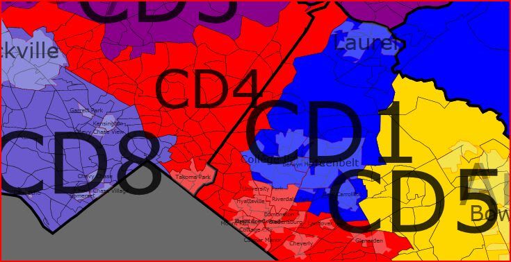
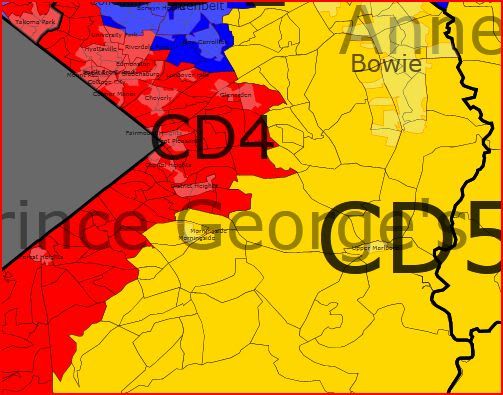
    However, I am not convinced that the marked rightward shift would have occurred inevitably had the boundaries not changed in the 2003 redistricting. Many residents in these districts were trending Republican at the presidential level, but felt comfortable continuing to vote for Democrats at the congressional level. But in 2004, the redrawn districts included areas that had previously been represented by Republicans or by other targeted Democratic members, meaning the advantage of incumbency was greatly diminished. This led to the defeat, party switching, or retirement of all the legislators listed above, but I believe, also contributed to these areas becoming more Republican at the presidential level in 2004 and 2008. Without the option to vote for a familiar incumbent Democrat for Congress further down the ballot, voters felt less inclined to vote for a Democrat at any level, including President. Had the 2003 redistricting not occurred, I believe not only that several of these lawmakers might still be in office, but Obama may have even performed better in these districts in 2008.

    Other than the representatives just discussed, I believe that all of the other Democratic and Republican incumbents would still be in office right now, with the possible exceptions of John Culberson (R, 7th) and Henry Bonilla (R, 23rd), whose districts would have become much more competitive by the end of the decade. But I think this analysis shows that in the long-term, Texas is turning blue, and it is only a matter of time before the shifts to the Democrats in the Houston area, the Dallas/Forth Worth Area, and Central Texas finally push Texas into the Democratic column.

    By what margin will Bob Shamansky win?

    View Results

    Loading ... Loading ...

    GOP Gerrymander of MA–Ask and ye shall receive!

    This diary was inspired by a comment from Nichlemn on markhanna’s recent diary which read, “[Other blogs] are for people who want to know who’s likely to win the next big election. SSP is for people who want to know who’s going to win the Democratic primary in UT-03 or draw a Republican gerrymander of MA.” Well, I’ll leave the Utah forecasting to someone else, but here is a redistricted map of the Bay State with the GOP running things!

    Note: If this is against the rules–a Republican gerrymander on a Democratic site–please take it down, and I apologize. If it’s OK, let me know if you like it, because I have one for New York too!

    A few things to note before we get into it:

    1. Massachusetts, unfortunately, will be losing a seat after the Census. I guess the weather is better elsewhere. This map is for nine congressional seats.

    2. The current 10-seat map is a very ugly and somewhat unnecessary gerrymander. (Please feel free to venture a guess as to what Frank’s or McGovern’s district looks like now.) Democrats control all 10 districts, but probably would anyway on a fairly-drawn map. However, the current plan is designed to favor Boston-area politicians, as 6 of the 10 members of the current delegation live within 5 miles of the Hub. As a result, Middlesex County is split between 7 districts, Norfolk County has four spaghetti strands, and there is no Member from the southeastern part of the state. I tried to improve on the geographic balance somewhat.

    3. Getting even one or two GOP seats was tough! The thing with Massachusetts is that Democratic strength is so evenly spread out across the state. President Obama won 302 of the 351 cities and towns, and won no less than 43% in any community statewide. To further complicate things, most of the 49 communities John McCain did win are inconveniently located near Democratic bastions like Worcester, Lowell, and Taunton. Thus, this “Republican gerrymander” is made up of 7 safe Dem seats, 1 tilt R seat, and 1 likely/safe R seat. I doubt there is any other state where a gerrymander means you have a shot at 2 of 9 seats!

    4. Everything is based of presidential results. While Scott Brown put up nice numbers, there is no reason to think this will change long-term voting patterns. There is no partisan data yet for MA, so I used town-by-town results to estimate the leanings.

    And here we go!

    MA-01 John Olver (D) vs. Richard Neal (D)


    Partisan Data: D+15-20. Obama probably got ~70% here.

    Finally, Western Massachusetts has its own district, and it’s a mix of bohemian rural towns and the industrial city of Springfield. Politically and culturally, this area has much more in common with Vermont than with the rest of Massachusetts. Home to Amherst, Williams, Smith, and UMass among others, this district is both very Democratic and very liberal (not always the case here.) I drew this to be a fair fight between veterans Olver and Neal, with about equal amounts of population from their current districts. My guess is that Olver would retire in this situation.

    MA-02 Jim McGovern (D)


    Partisan Data: PVI around D+10. Obama scored in the low 60’s here.

    An ugly yet efficient Democratic vote sink in Central Massachusetts, this is mostly new territory for McGovern but he won’t be complaining. His current district, which went strongly for Brown, is more moderate than its PVI suggests, and as one of the most liberal members of the house McGovern could be vulnerable there if not for his immense personal popularity. He retains his home base in Worcester and adds friendly territory to the north, east, and west. This district will be a pain to represent, as Fitchburg, Longmeadow, and Hopkinton have little in common.

    MA-03 (purple) and MA-04 (red) OPEN


    MA-03 Partisan Data: R+6. McCain 52, Obama 47

    Here’s the first, and better, of the two opportunities for the GOP on this map. The district is made up mostly of exurbs of Boston, Providence, and Worcester, combined with the wealthy South Shore (Plymouth County.) In fact, it’s the only Massachusetts district without a significant urban area. I-495 runs right through the heart of this district, and a Republican from the Franklin area like St. Sen Richard Ross would be favored in this race. If Joe Malone wins the current MA-10 this year, this would be his district. Scott Brown also lives here and probably approached 70% of the vote in the January Senate race.

    MA-04 Partisan Data: D+7 or so. Obama was around 60% here.

    I know my map will never be drawn, but seriously, this district must be. As it stands now, men from Worcester, Newton, and Quincy represent the South Coast, Cape, and Islands,  which are a world away from those other places. This plan unites the three, whose economies are heavily depending on fishing, and in the case of the South Coast, shipping. Politically, the Inner Cape is conservative, the Outer Cape and Islands are very liberal, and the South Coast is dominated by the Democratic cities of New Bedford and Fall River. If Rob O’Leary (D) wins the MA-10 race this year, he will be a perfect fit for this district.

    MA-05 Niki Tsongas (D)


    Partisan Data: PVI R+3 McCain 49, Obama 49

    Niki Tsongas is the weakest member of the current delegation, vastly underperforming in her only contsted election so far, and I made every attempt to draw her into a McCain district. Well I did–by about 250 votes. This plan chops off the liberal southern half of Tsongas’ current district and replaces it with Worcester’s northern suburbs and some Boston exurbs from Essex County. Most of the population comes from the conservative (by MA standards!) Merrimack Valley, which keyed Brown’s win, but geography forced me to include the liberal mill cities of Lowell and Leominster. Thus, Tsongas or another Dem wll have a shot, but the GOP should have a slight edge in a an even year.

    MA-06 John Tierney (D)


    Partisan Data: D+10ish. Obama probably cracked 60.

    This is what remains of fast-growing Essex County after the conservative towns were given to MA-05 combined with the blue-collar cities of Revere, Chelsea and Winthrop in Suffolk County. The industrial and very Democratic city of Lawrence, which I had to keep out of Tsongas’ hands, is responsible for the ugly arm in the northwest. Tierney will cruise here.

    Metro Boston Map


    MA-07 Ed Markey (D) vs. Barney Frank (D)

    Partisan Data: D+15 at a minimum. Obama would have been in the mid to upper 60’s.

    Well, I couldn’t squeeze any more than two gettable districts for the GOP here, so the obvious consolation prize was throwing two of the most senior and powerful Democrats in Congress into the same district! But fear not, Dems: there’s a solution here. Markey has considered Senate runs before and may run against Brown in 2012, giving Frank a clear field. If Markey stays in the House, he’ll be geographically favored, and Frank can move to the Cape and run in the new MA-04 since he already represents a good chunk of the South Coast.

    Politics aside, this Middlesex County district makes good sense. These are the primary western suburbs of Boston (MetroWest, as they are called), and are for the most part very wealthy and very liberal. Boston College, Tufts, and Brandeis are all in this district.

    MA-08 Mike Capuano (D)

    Partisan Data: D+32 or so, Obama won about 85%.

    One of the most Democratic districts in the country, there’s little change here. Latte-liberal Cambridge and Brookline and blue collar Everett and Somerville combine with the majority of Boston to keep Capuano super-safe. I tried to put the most liberal parts of the Hub here–Beacon Hill, Back Bay, JP, Roxbury, Mattapan, and the South End are all included, as are Harvard, MIT, BU, Northeastern, and dozens of others. It’s 55% white, but MA has actually been losing minority population so I don’t think we’re in VRA trouble.

    MA-09 Stephen Lynch (D)

    Partisan Data: D+7. Obama was in the high 50’s.

    Our final district belongs to the most moderate member of the current delegation, Stephen Lynch. The new district is very similar to his old one, combining most of suburban Norfolk County with the less liberal parts of Boston–Southie, West Roxbury, Hyde Park, and the white parts of Dorchester. The industrial town of Brockton is tacked on to the south to keep it away from the new MA-03. Scott Brown won here by more than expected, and this was one of those places where Obama underperformed Kerry. Nevertheless, it’s safe for Lynch until further notice.

    And there you have it! McGovern and Tierney are the clearest Democratic winners, Tsongas and Frank are both losers, and Neal and Olver must slug it out in the west. The GOP has two opportunities now and may or may not have a third by 2020 depending on long-term trends in Lynch’s district.  

    SSP Daily Digest: 5/25 (Afternoon Edition)

    Idaho: The only state holding primaries tonight is Idaho, where the only race that’s captivating is the Republican primary in ID-01 between Vaughn Ward and state Rep. Raul Labrador. Ward has quickly turned into one of this cycle’s SSP favorites, parlaying early establishment backing and financial advantages into a dead heat with the teabaggish Labrador through repeat instances of plagiarism and general cluelessness. In fact, the latest incident came just today, when Idaho’s senior senator Mike Crapo asked Ward to clarify an inaccurate e-mail that implied Ward had Crapo’s endorsement. In a Mason-Dixon poll from several days ago, Ward led Labrador 31-28. Politico has some extra background on the race today, focusing on the bizarre intramural rivalries within the Tea Party movement, as local Labrador-backing teabaggers have split off into the Tea Party People’s Front and the People’s Front of Tea Party over the national Tea Party Express’s backing of Ward.

    The Republican primary in the Governor’s race is also tonight, with incumbent Butch Otter facing challenges from wacko businessman Rex Rammell (whom you may remember from the 2008 Senate race, where he ran as an independent) and Ada Co. Commissioner Sharon Ullman. Otter, who was a libertarian-leaning House member prior to being Governor, hasn’t really drawn the wrath of the Tea Party though, and is polling well; the same Mason-Dixon poll finds him at 60%, with no opponent over 6%. Most polls in Idaho close at 8 pm Mountain time (10 Eastern), with some closing at 8 pm Pacific (11 Eastern).

    AR-Sen: The AFSCME is up with an $855K ad buy with a negative ad throwing the kitchen sink at Blanche Lincoln, even making fun of her absentee ballot screwup on Election Day. In Arkansas’s cheap media markets, that’s enough to keep the ads running all the way through the runoff.

    CA-Sen: While we at SSP are pleased and even a little honored that political insiders seem to be not only reading us but actually taking seriously things that we say, we also realize that they might not be familiar with all internet conventions. SSP allows (and encourages) user diaries. What is said in these diaries is not reflective of the opinions of the site’s editors. So, for instance, if a user diary says that CA-Sen is a “Tossup,” that does not mean that Swing State Project is calling CA-Sen a “Tossup,” which is precisely what the Carly Fiorina campaign was busy tweeting today.

    NC-Sen: If you can’t beat ’em, join ’em. Third-place Democratic primary finisher Kenneth Lewis has signed on as campaign chair for Elaine Marshall. Marshall faces a runoff against Cal Cunningham, who got a good endorsement of his own yesterday, from Jim Neal (who you might remember lost the 2008 Senate primary after running to Kay Hagan’s left).

    WI-Sen: You see allegations of this kind of thing in small-ball state legislative contests a lot, but usually when you get up to the U.S. Senate level, you have your staffers do this kind of thing. Well, I guess Ron Johnson is a man of the people, willing to go out there and get his own hands dirty tearing down his opponents’ signs (as seen on this video).

    AL-Gov: Artur Davis is out with a last-minute hit on Ron Sparks, throwing around “corruption” in reference to the thorny issue (in Alabama) of gambling. Usually campaigns like to close on a happy note; is Davis worried about a last-minute Sparks surge?

    MN-Gov: With Margaret Anderson Kelliher having announced a running mate pick, the other two guys in the Democratic primary have now, too. Mark Dayton picked state Sen. Yvonne Prettner Solon. She represents Duluth, an important but oft-overlooked Democratic stronghold in the state’s north. Matt Entenza seems to be going for star power rather than geographical balance, though, reportedly asking retiring news anchorwoman Robyne Robinson.

    CA-36: Looks like the Democratic primary between Rep. Jane Harman and activist Marcy Winograd is getting nationalized. Democracy for America (the descendant of the Dean campaign) is endorsing Winograd over the centrist Harman in this D+12 district.

    HI-01: A day after sounding noncommital about running in the regularly-scheduled primary in the 1st after finishing a surprising 3rd in the jungle-style special election, Ed Case is now confirming that he will keep running. Case has challenge Colleen Hanabusa to jointly commission a poll on who’s more competitive against Charles Djou (who was sworn in today, by the way) and the loser would drop out. Um, maybe the time to do that would be before the weird special election, not before the conventional primary where Hanabusa’s probably the favorite.

    OH-18: State Sen. Bob Gibbs and ex-state Agriculture Director Fred Dailey will have to wait a while longer for a conclusion to their super-close GOP primary, as SoS Jennifer Brunner ordered a recount. Gibbs finished ahead of Dailey by 156 votes, out of 52,700 (so it falls within the half a percentage point margin where an automatic recount is ordered by state law).

    VA-02: The GOP primary in the 2nd seems to be following a familiar pattern this cycle: the establishment candidate wins with a plurality after the Tea Partiers and assorted other hard-right constituencies can’t unite behind any one standard-bearer. A POS internal poll from wealthy auto dealer Scott Rigell (who has a bipartisan contibution record that must be dismaying to the local teabaggery) has Rigell way in the lead at 47, followed by 10 for Bert Mizusawa, 9 for Scott Taylor, 6 for Ben Loyola, and 1 each for Ed Maulbeck and Jessica Sandlin. Virginia’s primary is on June 8, but remember that, unlike most Southern states, they don’t employ runoffs.

    WI-07: EMILY’s List is getting involved in the open seat race in the 7th, now that state Sen. Julie Lassa has the Democratic field to herself. Their endorsement give her access to a nationwide donor base.

    Nevada: Democrats in Nevada have been able to point to a steadily increasing registration advantage over the last few years, but that petered out in the state’s newest release of numbers. The GOP increased its share, not by gaining more new registrations than the Dems, but by losing fewer registrations! Dems lost 42K since January, the GOP lost 20K, and nonpartisans went down 13K. I doubt people are burning their registration cards in a fit of pique, which instead suggests that there’s a lot of migration out of Nevada this year as it’s particularly hard hit by unemployment and foreclosures.

    Redistricting: Here’s some bipartisanship you can believe in: GOP Rep. Mario Diaz-Balart and Democratic Rep. Corrine Brown — both beneficiaries of minority-majority districts, including an ugly gerrymandered one in Brown’s case — joined together to sue to stop the Fair Districts initiative that will be on Florida’s ballot in November.