Michigan Redistricting 2012: 9-5 GOP

Quick History

The Republicans controlled the redistricting process in 2000, shifting the map from a 9-7 Democratic advantage to a 9-6 Republican one. (Michigan lost a seat in reapportionment.) They did this by redistricting three seperate pairs of Democratic incumbents into the same districts, thereby creating two new open Republican seats elsewhere. Architect of this plan? None other than then-state-senator Thaddeus McCotter, who oh-so-thoughtfully created one of those new open districts around his home base.

The GOP plan had turned into a little bit of a dummymander, since by 2008 the Democrats had flipped two districts to get an 8-7 advantage. This week's election, however, has restored the Republican's 9-6 edge. The 1st and 9th districts are in opposite hands from the 2002 elections; all other districts are controlled by the same party that won them eight years ago. (Wikipedia’s version of the pre-Tuesday districts is above for reference.)

The Genesis of this Plan: Failed Attempts

One of my consolations on election night was the idea that even with control over redistricting again, the Republicans couldn't really make it any worse. At the time, it looked the the Democrats were going to be down to five districts: Dearborn-Ann Arbor, Flint-Saginaw, Southfield-Warren, and the two Detroit districts. That seemed like pretty much the rock bottom base of support for the Democrats in Michigan. But then Gary Peters pulled out a narrow victory, and I started to look to see whether the Republicans could get the Democrats down to five after all. Michigan is almost certainly losing another district, so let's see if it can be made a Democratic one.

Four of the six Democratic seats seemed pretty much untouchable. The VRA-protected Detroit-based 13th and 14th districts are, of course, ridiculously Democratic. Sander Levin's 12th district pulls together an only somewhat less-ridiculously-Democratic set of inner suburbs on Detroit's north side. And despite Dale Kildee's narrower-than-expected win on Tuesday, Flint is big enough to dominate pretty much any district you could conceivably put it in. That leaves Gary Peter's 9th district and John Dingell's 15th district as the remaining targets.

My first attempt actually took on John Dingell's district. Stretching from blue collar Dearborn to the university town of Ann Arbor, it was created as one of the three "pairing" districts, setting up then-Representive Lynn Rivers against Dean of the House Dingell. Dearborn was easy to move into John Conyer's 14th district. Ann Arbor has to end up in Democratic district, so I swung Gary Peter's 9th district around to pick it up. Thad McCotter's 11th then mostly gives up its claim on Oakland county to pick up the rest of the dismembered 15th.

The problem with this plan from a GOP perspective is what it does to McCotter. The distict is probably about 60% – 70% new to him, and it's not nearly as Republican as his old district. I haven't run the numbers, but just from eyeballing it, I would be surprised if this version of the 11th district didn't have a Democratic PVI.

My second attempt left Dingell's district more-or-less alone. (As pictured, all of Dingell's hometown of Dearborn ends up in Conyer's district, but this could possibly be played with.) Instead I merged McCotter's 11th district with Peter's 9th district. The resulting district has about half of its population come from each district. (Old Peters in blue; old McCotter in green.) It cuts out the most Democratic parts of each district (Wayne, Westland, and Garden City for the 11th; Pontiac, Auburn Hills, and Royal Oak for the 9th). Again, I haven't run the numbers for PVI; I suspect it's a Bush '04-Obama '08 district.

McCotter probably isn't the best candidate for an incumbent vs incumbent race, but this district — in isolation — would probably suit the state GOP fine.

The problem is what the rest of the state looks like.

Merging the 9th and 11th pulls Mike Roger's 8th district further east and north. This saddles the already swingy 7th district just won by Tim Walberg with heavily Democratic Lansing. The 7th, in turn, now donates Democratic-leaning Battle Creek to Fred Upton's already even-PVI 6th district.

The Solution

So if I couldn't dismantle Dingell's district without giving McCotter too much hostile territory, and if merging McCotter's district and Peter's district resulted in weaker districts for Walberg and Upton, then what?

I was stumped for about a day, when the answer occured to me: attack Sander Levin's 12th district instead.

By bringing the Detroit-based 13th district north across Eight Mile into Macomb county, I could merge the Oakland portion of the 12th district into the 9th. (The old 12th is roughly outlined in white.)

Brief District-by-District Rundown

I'm considering working through the data to get firm PVIs for the proposed districts. For now, you have eyeballing-it. I did refer to the 2004 and 2008 numbers while drafting; I just never actually ran the calculations.

1st District (Blue)

This district is newly captured by Republican Dan Benishek. In the 2000 redistricting, this district was pulled down the Lake Huron coast towards Bay City as part of the dismantling of then-Representative Jim Barcia's district (he got paired with Dale Kildee in the 5th). Without such concerns, I pulled it down the Lake Michigan shoreline instead. Adding the Traverse City area instead of the upper Saginaw Bay area should make this district just slightly more Republican. Traverse is also a better cultural fit for the district. (Note that everything not pictured in the north of the state is in this district.)

2nd District (Green)

This district is currently Michigan's most Republican district by PVI. I don't think my alterations will change that. It gives up its northern reaches to the new 1st and stretches inland, taking in Grand Rapids' northern suburbs and exurbs.

3rd District (Purple)

The primary Republican concern with this district is making sure it has enough suburban/exurban territory to overwhelm the Democratic urban core in Grand Rapids. It gives up some territory north of the city and gains Eaton county to the east. I think this will be slightly more Republican than the existing 3rd.

4th District (Red)

As currently configured, this district is something of a left-overs district, taking in the northern counties not in the Upper Peninsula-based 1st or the Lake-Michigan-coast-based 2nd. Under my proposal, it becomes a somewhat more focused Central Michigan district. Largest city (and hometown of incumbent David Camp) Midland is now in the center of the district instead of on its eastern fringe. It takes in all of Democratic Bay county, but I think the rest of the territory is Republican enough to handle it.

5th District (Yellow)

The proposed 5th district is much like its 1990s-district-plan predecessor, taking in much of the Thumb instead of Bay City. This is because eliminating Levin's 12th district pulled Candice Miller's 10th district out of the Thumb. Since it's over that way anyway, it runs a tendril down the St Clair River to relieve Miller of smallish-but-heavily-Democratic Port Huron.

6th District (Teal)

Not much changes for the 6th. It exchanges a few townships in Calhoun county for a few in Branch, and takes in the rest of Allegan county. That last change should make it slightly more Republican. Incumbent Fred Upton should remain fine here.

7th District (Grey)

This proposal's greatest weakness. Newly re-elected Tim Walberg has a district with a PVI of R+2. Getting Monroe county from the dismantled-by-reapportionment 15th in exchange for giving the new 3rd Eaton county is essentially a wash. I just don't think that there's much the Republicans can really do to shore this district up.

8th District (Slate Blue)

Still subsumes Lansing in a sea of Republican-heavy exurbs. This configuration gives up somewhat-Republican Clinton county to gain very-Republican Lapeer county, so Mike Rogers should be happy.

9th District (Cyan)

The new 9th is one of the center-pieces of the plan. It combines most of Gary Peter's current 9th with about half of Sander Levin's current 12th. If it came to a primary, I'm not sure what would happen. Where the current 9th was designed as a Republican seat that's just slipped away, this 9th would be a Democratic safe seat, anchored by Southfield, Royal Oak, and Pontiac.

10th District (Deep Pink)

Candice Miller's 10th is pulled south by the elimination of the old 12th. Losing most its rural hinterland, the new 10th is definitely more Democratic than the old one, but I don't think it's that much more. I think Miller should still be fine. In one of the rare set of calculations I did do, the portions of Macomb county not in the district (ie, in the new 13th) voted for 63% for Obama. The portions of Macomb in the district voted only 52% for Obama. That probably means that Bush won the new 10ths portion of the county in 2004 (here, we're back to no calculations.)

11th District (Lime Green)

In order to shore up McCotter, the district loses three of its inner surburbs and snakes around the north side of the new 9th to pick up some more heavily Republican territory. McCotter should put up much better numbers in this reconfigured district.

12th District (Cornflower Blue)

With the dismantling of the old 12th, I reused the district designation for the reinvention of Dingell's dismantled-by-reapportionment 15th. The new 12th loses Monroe county to pick up the southern portions of Downriver. I'm pretty sure this will push its PVI in an even-more Democratic direction, and Dingell (and/or his successors) should be safe here all decade.

13th District (Salmon?)

The other centerpiece of this plan. It takes in roughly similar portions of Detroit as its predecessor (along with the Grosse Pointes and Harper Woods.) Instead of stretching into Downriver, though, it crosses over into southern Macomb, snatching away the eastern half of Levin's district and saving Miller from having to take on the most Democratic parts of the county. VRA: 53% black, 42% white.

14th District (Olive Drab)

Conyers' new district takes in basically the same portions of Detroit as his old one. The primary difference are the addition of Redford township, the subtraction of any part of Dearborn, and the taking in of the northern half of the Downriver communities instead of the western half. VRA: 53% black, 34% white.

Pre-Conclusionary Note

I was originally concerned about whether this was too much county-splitting in the Detroit area, but it's actually less than currently exists. Currently, the tri-county Detroit metro area has the following configuration:

Wayne: 2 full districts (13th, 14th), 2 partial districts (11th, 15th)
Oakland: 1 full district (9th), 3 partial districts (8th, 11th, 12th)
Macomb: 2 partial districts (10th, 12th)
for 10 total county-fragments.

Under this new configuration, the tri-county Detroit metro area looks like this:

Wayne: 1 full district (14th), 3 partial districts (11th, 12th, 13th)
Oakland: 1 full district (9th), 2 partial districts (8th, 11th)
Macomb: 2 partial districts (10th, 13th)
for 9 total county-fragments.

Conclusion (TL;DR version)

By eliminating Levin's 12th district, I created four packed super-safe districts for the Democrats in the metro Detroit area, with one other safe Democratic district in the Flint-Saginaw area. Republican incumbents in the 1st, 3rd, 6th, and 11th districts are shored up. Republican incumbents in the 4th and 10th districts take minor hits. The Republican incumbent in the 2nd district needed no help; and the one in the 7th district is unhelpable. This plan would more or less lock in an 8 GOP – 5 Dem – 1 swing district pattern for the rest of the decade.

Ohio Redistricting 2012 – 13-3 GOP

Alot of people have pointed out that House losses in Ohio shouldn’t be a big deal because the GOP has already gerrymandered Ohio to their maximum advantage.

However, what that fails to take into context is that Ohio is about to lose 2 of its 18 seats once the census figures are published, which gives the GOP an opportunity to take a 13-5 House advantage to 13-3. Below are some scenarios that will enable them to accomplish that:

Lost Seat #1: Shore up Jim Renacci, combine Tim Ryan and Betty Sutton.

This scenario seems like the easiest call for the Republicans. Currently Renacci was just elected to OH-16 which contains Stark (Canton/Massillon), Wayne (Wooster), Medina (Cleveland exurbs), and Ashland (rural, very conservative) Counties.

This district was drawn in 2000 to protect GOP moderate stalwart Ralph Regula who lived in the Canton area. Canton & Stark County also happen to be the most Dem friendly parts of the district as currently constructed, voting for both Kerry and Obama in 2004 & 2008. With Renacci’s home in Wadsworth (Medina County), it will be easy for Republicans to combine parts of the current OH-10, 13, 16, 17 & 18 into two districts.

Renacci’s new district will shift north and west, abandoning Stark County in the process by swallowing the Medina & Cuyahoga County portions of OH-13 (these suburbs: Strongsville, North Royalton & Brecksville are the most reliably GOP leaning areas of Dem-heavy Cuyahoga County), the eastern Lorain County portion of 13 (Avon, Avon Lake, North Ridgeville: fast growing GOP suburbs) and the western edge of OH-10 (Bay Village, Rocky River, Westlake). Whatever portions of Wayne & Ashland counties in the southern part of his current district that won’t fit population-wise can be eaten up by Gibbs in present-day OH-18.

That leaves a new Democratic district comprised of Akron, Canton & Youngstown that draws Sutton’s home in Copley (just outside Akron) and Ryan’s home in Niles (just outside Youngstown) into the same district and forces a primary between the two most promising congressional Dems in Ohio. Taking one of these two out will be a major boon to the GOP by eliminating or weakening the strongest challengers to Portman or Kasich in 2014 and 2016.

Lost Seat #2: This is where it gets harder for the GOP to come up with another lost Dem seat. The possibilities in order of likelihood:

1. With Renacci squeezing Kucinich to the west, the Republicans could draw a new minority-majority district in Cleveland by moving Fudge and Kucinich into the same district. This would involve LaTourette scraping off the eastern edge of Fudge’s territory. The new map would basically be the city of Cleveland + inner ring suburbs.

In this situation, Kucinich would likely retire or move to the suburbs to challenge Renacci where he would lose in an R+ district.

2. Split up Columbus 3 ways. Columbus presents a problem for Republicans in the state. It is the area that is experiencing the most population growth in the state, and it is also the area that is trending the strongest towards Democrats.

Currently OH-12 (Tibieri) and OH-15 (Stivers) represent the city by drawing in as much as they can from the sparsely populated surrounding counties. Even here, both districts are perpetually threatened, with Kilroy (D) holding OH-15 for one term before her defeat this year. OH-12 is actually the bluer of the two Columbus districts, but Dems can never seem to recruit the right candidate to beat Tibieri.

To stave off flipping one of these seats permanently to Team Blue, the GOP could find a way to give Gibbs or Turner a slice of the Columbus pie and keep Dem votes divided.

3. The last scenario I could see happening doesn’t get the GOP to 13-3, but could be a prudent strategic move for them in SW Ohio.

By eliminating OH-2 (Schmidt), they could expand Chabot’s district to the east and leave him less vulnerable to a Democratic wave year like 2008. Turner and Johnson (OH-6)would take what was left of Mean Jean’s territory and help shore up their own re-election hopes.

Schmidt’s constant underperformance is likely a drag on RCCC funds as they constantly have to defend the 2nd most Republican seat in Ohio due to the relative unpopularity of Ms. Schmidt.

These are just a few scenarios and I’m sure I’m missing others. Another possibility would be to force Marcy Kaptur and Bob Latta into a showdown, but Kapur’s seat is already so gerrymandered, I’m not sure how you draw in Toledo & the islands without strengthening the Dems.

Any thoughts?

Marymander 2012: A 7-1 Vision for the Old Line State

Okay, so, Maryland has the trifecta, and it’s not afraid to use it. Republicans get to carve up some states they control in particularly nasty, ugly ways (I’m not looking forward to seeing how Augusta determines to create a 1-1 split, probably ousting Rep. Michaud in the process; North Carolina will be a veritable bloodbath in redistricting, and New Jersey won’t be much better), so I think Democrats should get to fight back in states like Maryland, Washington, and hopefully New York.

So, without further ado, I present to you a positively wicked 7-1 redistricting proposal for my state of residence.

Let’s start with MD-01. I guess the app decided to plop the “CD01” right where D.C. is, so just to be clear, I’m not advocating Maryland annex the nation’s capital as its new 1st congressional district.

MD-01 is pretty straightforward. I chopped most of the population centers out of Rep. Bartlett’s MD-06, including the swing city of Frederick, and combined it with Rep.-elect Harris’s Eastern Shore district, now with 100% less Anne Arundel County. Back to that in a second.

The important thing about MD-01 is that it’s the Republican district. According to the app, this hypothetical new MD-01 gave Sen. McCain 58% of the vote in 2008, with only 40% for the skinny Illinois senator we now know as President Barack Obama. This MD-01 would not be the safest Republican district in the country, but it’d be pretty safe.

Next up, MD-02. It was roughly at this point that I realized how messed up the current congressional districts of Maryland are. It’s bad enough to include parts of Anne Arundel County in a district with the Eastern Shore, but the way in which Rep. Ruppersberger’s district is drawn would be punishable by death in some countries.

What I decided to do is simplify things without sacrificing, well, let’s call it functionality. I also needed a way to swallow up some populous parts of MD-01, namely most of Baltimore County and parts of Harford County. This MD-02 includes parts of Baltimore City, although less than is currently drawn into the district because it no longer slithers south into Anne Arundel County. I mean, come on, guys.

The tradeoff of consolidating MD-02 with an eye toward siphoning off conservative MD-01 constituents and balancing them with ultra-liberal North Baltimore (the parts of Baltimore City included are a mix of super-white and super-black precincts, because a Democrat is a Democrat and we don’t make bones about it in MD-05) is that the district isn’t quite as solidly Democratic, but it’s hardly a swing district in an average year. Obama won this hypothetical MD-02 with 57% of the vote; McCain scraped up 41%.

And now for MD-03. If the current MD-02’s blatant and bizarre gerrymandered shape merited the death penalty, the lawman would bring back hanging, drawing, and quartering for MD-03. Staunchly liberal Rep. Sarbanes holds court over this district, drawn for the benefit of white dudes just like him, right now.

Because the way MD-03 is drawn right now is just plain stupid and there was still some of Harford County that needed addressing, I decided to run the new MD-03 from a tiny portion of western Cecil County, technically part of the Eastern Shore, into southern Baltimore County, with some spillage into northern Anne Arundel County and a weird little tentacle extending briefly into Howard County. It also includes the lion’s share of Baltimore City. I’ll grant it’s not tons better-looking in my drawing than it is now, but at least I didn’t gerrymander it for the benefit of those poor besotted white Democrats.

My version of MD-03 is DemStrong, having gone 60% for Obama to 38% for McCain in 2008. It’s now 30% black, proportionally almost twice what it is now, but if Sarbanes or some other white Democrat can’t get African Americans to vote for him, that’s his problem.

On to MD-04. I don’t know why this district is drawn so weirdly right now, because I feel like the way I’ve drawn it makes a lot more sense. Oh, I’ve got it: it’s gerrymandered to be majority-black. Rep. Edwards, who is a damn good congresswoman, represents our current version of MD-04.

My version of MD-04 covers about half of Montgomery County, a few conservative precincts in Howard County I didn’t want going elsewhere, and most of northern Prince George’s County. It would become the new home of the University of Maryland, which doesn’t hurt a Democrat’s vote share.

Indeed, this version of MD-04 went for Obama 75-24. That’s dominating. I could probably feed more of Howard County into this district if I wanted to, but I decided to keep things as even as possible between the eight (2000 population for all is between 661,000 and 663,000, by the way).

MD-05 is my district. I switched around some parts of the eastern D.C. suburbs for compactness, although my incarnation of the district now represented by Rep. Hoyer, the House majority leader for not a whole lot longer, still has a weird finger extending into northern Prince George’s County, capturing Greenbelt and a few other mid-sized suburbs.

The majority-black eastern suburbs more than balance out swingy southern Maryland in my drawing of MD-05. This new district would actually be majority-black according to the 2000 Census, which says 51% of its hypothetical constituents are African American.

As you might expect, this MD-05 is heavily Democratic. It would have broken 77-23 for Obama if it had been a district back in 2008; either way, that’s what the voters who would be within its new boundaries did.

MD-06 is fun. It’s a completely different district in its present form, being the domain of arch-conservative Rep. Roscoe Barlett in northern and western Maryland. As mentioned before, I had MD-01 consume most of MD-06, so this new district is more fun.

This MD-06 is not the most fun, but it’s certainly the most all-new, because I basically carved it out of parts of the current MD-01, MD-03, and MD-04. It’s basically almost all of Anne Arundel County plus a good chunk of Prince George’s County, including Bowie, a midpoint city between D.C. and Baltimore.

Ultra-liberal Bowie and somewhat liberal Annapolis serve to balance out conservative Anne Arundel County. Voters in this hypothetical MD-06 broke 57-41 for Obama, which is not so bad when you consider the current version of MD-06 has a PVI of R+13.

Helping mop up is MD-07. Right now, MD-07 is a majority-black district represented by Rep. Cummings and covering most of the black neighborhoods of Baltimore City and Baltimore County, as well as most of Howard County. It had to take a hit, and I apologize for that.

There was a lot of the current MD-06 to split up, and a good portion of it was awarded to this proposed MD-07. It’s basically the current MD-07 with a few neighborhoods in Baltimore City split off and given to MD-02 and MD-03, then a huge swath of Carroll County and about a third of Frederick County absorbed for population balance. It’s a lot bigger, but it’s not abnormal population-wise (still falls within that range I mentioned earlier, at least under the 2000 Census).

Despite expanding to cover so large an area of rural, conservative Carroll County, this MD-07 would remain a Democratic stronghold. It broke 2:1 for Obama in 2008. It’s only 39% black with so much of mostly-white Carroll and Frederick counties added in, but a Democrat should be able to walk away with any election here regardless of race.

Last but not least, MD-08. Currently represented by plucky DCCC chair Rep. Van Hollen, the present version of MD-08 covers most of Montgomery County, in particular the eastern, whiter parts of Maryland’s richest county-level subdivision.

I decided I could put it to better use, so I gave parts of Montgomery County to MD-04 without radically changing the boundaries, and then I expanded up into Frederick County and parts of southern Washington County. This is where the city of Frederick, which broke fairly decisively for Obama in 2008, wound up.

The new MD-08 would have a 2008 voter breakdown almost identical to that of MD-07. 66% of its voters went for Obama; 32% of them went for McCain. It’s only 10% black, because of how predominantly white Frederick County and the parts of Montgomery County is covers are.

So there you have it. It can be done. Let’s hope Annapolis pulls the trigger, because we shouldn’t let the Republicans have all the fun in 2012 redistricting.

Ohio GOP Gerrymander: 9-5-2 Republican map (UPDATE: 9-6-1 see below)

This is a scenario if Republicans were to win the state House, this is a probable map since they already control the State Senate. (I’m pretty sure the legislature does this, or is it a commission?)

UPDATE: New proposed Columbus map in the comments (sorry mods if its too big!!), creating a safe Columbus (60%+ Obama, 200,000 African Americans) district and a likely Republican suburb district.

Cincinatti area:

Photobucket

OH-01:

Hamilton, Cincinatti suburbs

Steve Driehaus (D)*

Adds more Republican Butler County (avoiding West Chester, where Boehner lives) and loses all of the heavily black parts of Cincinatti (much like how Columbus’ district are already). Driehaus is D.O.A here, but he could run in the 3rd district, where the black parts of Cincinatti are in Jean Schmidt’s district. Eitherway, this district is a Republican one.

OH-02:

Middletown, Troy, West Chester

John Boehner (R)

Warps around Dayton, but still extremely Republican. Minority (or Majority) Leader Boehner is safe.

OH-03:

Most of Cincinatti, Portsmouth

Jean Schmidt (R)

Schmidt is screwed. That’s putting it nicely. If she only ecks out single-digit wins in an extremely conservative district, she won’t win here with all the new African-Americans in the district. I’m guessing Steve Dreihaus would run here, and the Republican gerrymander actually helps him surprisingly.

Photobucket

OH-04:

Dayton, Kettering, Springfield

Michael Turner (R)

Turner keeps his Dayton-area base and expands to Springfield via  Fairborn in Greene County. Also takes Mary Jo Kilroy’s  Madison and Union counties. Safe.

OH-05:

Lancaster, Beavercreek, Zanesville

Steve Austria (R)

Austria’s district expands to take in two of Zack Space’s most visible cities, Zanesville and Chillicothe.

OH-06:

Western Columbus and suburbs Most of Columbus

Mary Jo Kilroy (D)

Kilroy is probably slightly more safer, as ultra-conservative Union and Madison counties are out of her district and is entirely within Franklin County. Her race is still a toss-up to me though. Yeah nevermind, by making Kilroy safe, we also keep Pat Tiberi safe as well, which helps the GOP actually. Obama probably took in 64% in this district, so Kilroy can live another day. Now with exactly 200,161 African Americans!

OH-07:

Eastern Columbus, Delaware, Mount Vernon North and Eastern Columbus suburbs

Pat Tiberi (R)

What do you get when you combine extremely Republican counties outside of Columbus and the African-American heavy parts of Columbus? A swing district, like this one. Slightly a bit more African-American, Tiberi is still safe. Centered around Columbus makes Tiberi a whole lot safer, even if it helps another Democrat.

OH-08:

Lima, Findlay, Defiance

Jim Jordan (R)

Still the most conservative district in Ohio. Nothing to see here.

OH-09:

Bowling Green, Mansfield, Fremont

Bob Latta (R)

Mostly unchanged but expands into the Mansfield-area. Safe.

OH-10:

Toledo, Lorain, part of Elyria

Marcy Kaptur (D)

Expands to take in Lorain and parts of Elyria, safe for Kaptur.

OH-11:

Massilion, Kent, part of Elyria

Betty Sutton (D)

This district takes in Medina County and loses most of Akron. If this district was to be implemented, Sutton would probably lose this year.  Republican pickup.

OH-12:

Canton, Athens, New Philadelphia

Zack Space (D) vs John Boccieri (D) vs Charlie Wilson? (D)

WesternEastern Ohio’s population is dropping…fast. This district goes from Canton and swirvs its way down to Athens. Zack Space and John Boccieri both live here, but Charlie Wilson lives just right outside the boundaries but this area is still his. Who would win here? I’m guessing Wilson, but if he doesn’t run here i’d go with Space. Sorry John.

OH-13:

Youngstown, Steubenville, Warren

Tim Ryan (D) vs Charlie Wilson? (D)

This is where Charlie Wilson lives but most of this area is represented by Tim Ryan. Ryan is moderate enough for this district, so Wilson is in a predictament here.

OH-14:

Western Cleveland, part of Elyria

Dennis Kucinich (D)

Mostly the same but goes into Lorain County to pickup votes.

OH-15:

Eastern Cleveland, most of Akron

Marcia Fudge (D)

Here’s the district which bugged me the most. I’m not sure if it HAS to be majority-black, but i kept it that way anyways. stretches into Akron to take in African-American votes.

OH-16:

Mentor, Ashtabula, part of Akron

Steven LaTourette (R)

Slightly more Democratic due to the presence of Akron. LaTourette is still safe though.

More pictures:

Photobucket

Photobucket

Breakdown:

OH-01, OH-02, OH-04, OH-05, OH-07, OH-08, OH-09, OH-11,OH-16: Republican Seats

OH-03 (if Schmidt runs): Tossup seats

OH-10, OH-12, OH-13, OH-14, OH-15: Democratic Seats

6 Democratic Seats

1 Tossup seats

9 Republican Seats

If Schmidt doesn’t run:

10 Republican Seats

6 Democratic Seats

First redistricting diary, tell me what you think 🙂 (And no, i am not and will not do California. As much as i love my state, its too large and the precincts are annoying…Yes i’m talking to you Santa Clara and Kern Counties.)

Ohio Gerrymandered Both Ways

I spent the better part of the last 10 days diligently working on an exhaustive map of California (curse you, microscopic precincts of Contra Costa County!) using a method I don’t believe anyone on here has tried yet. And wouldn’t you know it, when I was just finishing up San Diego this morning, Safari decided it was going to quit and my entire map died with it. Too upset to go all the way back to CA-01 and start again, I decided I was going to post a diary today anyway, Safari-be-damned. So here are two maps of Ohio, one a Republican gerrymander and the other a Democratic gerrymander, that I drew a while ago but never got around to posting. Enjoy, let me know what you think, and I promise you I’ll get that California one up eventually!

Note before I begin: I’ve never been to Ohio, so I’m a bit of a rookie when it comes to the political niceties of the state. If I’m missing anything obvious, please let me know.

Ohio Republican Map: The “Four-Steve Plan”

Southwest Ohio and Cincinnati

OH-01 (Blue): Steve Driehaus (D) vs. Steve Chabot (R)

This district is drawn to help Chabot regain and hold his old seat in Congress. It’s still Cincy-based but gains a good portion of deep-red exurban Butler County from the current OH-08, and loses some of its inner-city portions. This configuration is probably R+1 or 2. Driehaus trails in the polls as it is, and this plan has a nasty surprise for him, as 15,000 of the black voters who swept him into office are now constituents of….

OH-02 (Green): Jean Schmidt (R)

This district, which only gave 40% of the vote to Obama, was hoarding Republican votes as it was but I didn’t want to hurt the notoriously weak Schmidt too much. Still, she’s capable of taking on the aforementioned 15,000 black votes, and also adds a little bit more of rural Southern Ohio.

OH-03 (Purple): Mike Turner (R)

Turner and Steve Austria inconveniently chose to live about 20 miles from each other, forcing the former’s district to stretch quite a bit and eat up some of Zack Space’s territory (his district is a casualty of this map.) Montgomery County (Dayton) voted for Obama and is the population center of this district, but OH-08 gets all the black precincts. Thus, Turner’s R+5 district is now R+9, with McCain getting 55%.

Columbus Area

OH-04 (Red): Jim Jordan (R)

Franklin County, home of Columbus, is fast-growing and trending more Democratic by the day. It gave 60% of its votes to Obama, but luckily for Republicans is an island of an ocean of conservative Ohio goodness. Thus, part of the city is sliced off and is attached Texas-style to the 60% McCain counties that border Indiana. No idea what the PVI is because I don’t know the precinct-level data for Franklin, but Jordan’s safe.

OH-07 (Grey): Steve Austria (R)

Austria takes in the sparsely populated and more moderate south of Franklin County, and holds onto most of his old district.  This is the swingiest of the four Columbus-area seats, but PVI-wise its probably not too different from Austria’s current 54% McCain seat.

OH-08 (Indigo?): John Boehner (R)

The Minority Leader currently has the most Republican seat in Ohio, and I doubt GOP map-drawers would disturb his seat too much. He gets 75% McCain Mercer County tacked onto the the northern end of his district in exchange for adding some more of downtown Dayton to help Turner.

OH-12 (Pale Blue): Pat Tibieri (R)

Tibieri is rewarded for holding down his Obama district against the 2006 and 2008 waves with a large swatch of conservative territory to the northeast of Columbus. His district contains less of Franklin than it used to, but now has most of the majority-minority precincts. The portion of the district outside of Franklin, which makes up about 3/5 of its population, voted 61% for McCain.

OH-15 (Orange): Steve Stivers (R)

This district is designed with Stivers in mind and is very similar to the neighboring 12th: a quarter of Franklin County attached seven exurban and rural counties that voted 3:2 for McCain. If Stivers came within a few hundered votes of winning a fairly strong Obama district in ’08, this one should be easy for him.

Note: I don’t know which of my districts Mary Jo Kilroy lives in, but she’d face an uphill fight in any of them. Also, while it is still possible to gerrymander Franklin County into 4 GOP seats, by 2020 it may be wiser to consolidate central Columbus into one safely Democratic district.

OH-06 (Teal): Charlie Wilson (D) vs. Zack Space (D) vs. Generic R

The new 6th, in the southeast of the state, is made up of the most conservative parts of the current 6th and 18th. Thus, Charlie Wilson and Zack Space are heading for a primary fight on a rather level playing field. The winner of this hard-fought contest will emerge to take on a Republican in a 56% McCain district with a lot of  territory unfamiliar to him. Not an impossible hold, but a tough one for Democrats in a region sliding away from them.

Northeast Ohio

OH-05 (Yellow): Bob Latta (R)

Latta’s district shifts westward and loses a point or two (down to  51-52% McCain.) He scoops up the rural, conservative leftovers of counties the voted for Obama but have given their liberal sections to Democratic districts. Also, the population center of this district is now in exurban Cleveland, which means Latta may face a primary from that area. I’ve never cared for him anyway.

OH-09 (Sky Blue): Marcy Kaptur (D)

Nothing new here, folks. The dean of the Ohio delegation keeps her base in Toledo and hugs Lake Erie like Lois Capps hugs the Pacific. Obama won 62%.

OH-10 (Pink): Dennis Kucinich (D)

High 50’s for Obama in western Cleveland and its suburbs. I decided to save Kucinich rather than pit him against one of the other northeastern Democrats because his “nay” votes from the left are nonetheless helpful for Republicans.

OH-11 (Lime): Marcia Fudge (D)

There are just enough African-Americans in Cleveland to keep a VRA majority-black seat in Ohio. Fudge’s percentages on the east side of the city are 51% black, 85% Obama.

OH-13 (Tan): Betty Sutton (D)

Sutton’s district is now dominated by her home county of Summit (Akron) but also takes in the college town of Kent and the west side of Canton. Obama scored in the high 50’s, much like in Sutton’s current district.

OH-14 (Taupe?): Steve LaTourette (R)

LaTourette is stuck in a tough place for a Republican. To the west is Cleveland, to the south Youngstown, and to the north Lake Erie. There is some conservative territory to the east, but it’s in Pennsylvania so that’s a no-go. He does have to expand somewhere, though, so I chose rural Trumbull and Portage counties, which are hopefully more conservative than the counties are as a whole, and the surprisingly Republican south and east of Cuyahoga County. This should be enough to nudge McCain over 50, a slight improvement over the current 14th.

OH-16 (Bright Green): Tim Ryan (D) vs. John Boccieri (D)

This is the Youngstown district, and Ryan should have no problem dispatching of Boccieri in the primary and whoever the GOP puts up in the general. East Canton as well as the liberal parts of Wilson’s district are thrown in for good measure. Boccieri could move and try to run against Latta, but it would be an uphill fight for him.

Summary: 3 Lean R (1, 6, 14), 3 Likely R (5, 7, 15), 5 Safe R, 5 Safe D

Ohio Democratic Map (the “Two-Steve Plan”)

Southwest Ohio

OH-01 (Blue): Steve Driehaus

Driehaus sheds the Butler County portion of his district and now has all of Cincinnati and its inner ring of suburbs. The black percentage ticks up to 25 and Obama probably was in the mid-to-high 50’s. Chabot might still have a chance this year, but Driehaus’ odds are far improved down the road.

OH-02 (Green): John Boehner (R) vs. Jean Schmidt (R)

It’s pretty easy for Democrats to eliminate the arch-conservative Schmidt by tossing her in with Boehner. This very red (McCain 60% +) district is made up of Cincinnati’s and Dayton’s exurbs and should be no trouble at all for the Minority Leader or any Republican who succeeds him.

OH-03 (Purple): Mike Turner (R)

The area between Toledo, Cincinnati, and Columbus is sort of a Bermuda triangle for Democrats, as you’ll be hard pressed to find anyplace that Obama broke 45%. The new 3rd combines the only county in this area that Obama won, Montgomery (Dayton) with marginal Clark County to create a 52/48 Obama district. Nevertheless, the PVI is R+1 and Turner will be favored. This seat becomes a tossup when he retires or runs for higher office.

OH-04 (Red): Jim Jordan (R)

This slice of rural Ohio goodness is about as clean-looking a Republican vote sink as you’ll ever see. McCain was in the 60’s here; a stronger Republican would flirt with 70% of the presidential vote. This might be the safest seat for the GOP in the Midwest.

OH-07 (Grey): Steve Austria (R)

Austria is one of the few Republicans who would prefer this map to my GOP gerrymander. He picks up most of Schmidt’s old district along the Kentucky border and retains his base southwest of Columbus.  With McCain in the high 50’s, Austria has this seat as long as he wants it.

OH-06 (Teal): Charlie Wilson (D)

Wilson’s district pushes ever so slightly north into the Democratic vote warehouse of Youngstown, taking about a quarter of the city. The rest of the district is made up of a selection of the least Republican counties of Southeast Ohio (a lot of 50/50 areas.) It’s not much, but the improvement does flip this slight McCain district into a slight Obama one. Wilson’s safe, but this is trouble for Democrats down the road.

Columbus Area

OH-08 (Indigo?): Zack Space (D)

Mr. Space, welcome to East Columbus! As the only endangered Democrat for hundreds of miles in any direction, Space is rewarded for his two wins in tough territory with a large chunk of Franklin County, attached by a thin strip to his home county of Tuscarawas. Who says ugly can’t be beautiful?

OH-12 (Pale Blue): Pat Tibieri (R)

Tibieri is a winner in both my maps, as once again he trades his part of Columbus for exurban and rural counties. This time, he gets almost all the red counties in Central Ohio, and is sitting comfortably in a 60% McCain district.

OH-15 (Orange): Mary Jo Kilroy (D)

Kilroy needs all the help she can get, so I gave her even more of Columbus than she has now. Then, I traded dark-red Madison and Union Counties for the more moderate Pickaway and Ross Counties to the south of the city. This move pushes Obama into the upper 50’s and should be enough for Kilroy to fend off the pesky Steve Stivers.

Northern Ohio

OH-05 (Yellow): OPEN

This new seat in north-central Ohio is designed with Democrats in mind, as Obama carried it with 54% of the vote. However, it’s not out of the reach of Republicans, especially not this year. Still, since this essentially replaces Latta’s district and we don’t want to spread the votes too thin in Northern Ohio, it’s acceptable. Latta could try his luck here but most of this territory is new to him.

OH-09 (Sky Blue): Marcy Kaptur (D) vs. Bob Latta (R)

Sorry Bob, this one’s not gonna happen. Dominated by Lucas County (Toledo), the dean of the delegation should have no problem retaining her seat. Even with the Republican-voting northwest, the new 9th still gave 61% of the vote to Obama. Kaptur’s small sacrifice frees up the lake counties to the west for the new 5th.

OH-10 (Pink): Dennis Kucinich (D)

This district takes Wayne and Medina Counties, which voted for John McCain by a combined 15,000 votes, and neutralizes them with a large slice of western Cuyahoga County (Cleveland). Kucinich could theoretically be in trouble here, but the most likely scenario is that he runs into a strong suburban primary challenger who goes on to easily hold this one for the Democrats.

OH-11 (Lime): Marica Fudge (D)

Exactly the same in both gerrymanders. 51% black. Ho hum.

OH-13 (Tan): Betty Sutton (D)

Sutton has it about the same on both maps as well. Once again, she claims all of Summit County (Akron) and has enough Democratic votes there to allow her to swallow Republican precincts in southern Cuyahoga and Steve LaTourette’s home precint (more on him later.) 57% for Obama this time.

OH-14 (Taupe?): Tim Ryan (D)

Ryan keeps all of his home county, Trumbull, as well as the majority of the city of Youngstown. Those alone are enough to keep him safe, which allow him to grab Ashtabula and Lake Counties as well as parts of Geauga and Cuyahoga from LaTourette’s old district. Mix it all together and you get a 59% Obama seat.

OH-16 (Bright Green): John Boccieri (D)

The most junior Democrat in the region, fittingly, gets the leftovers district. Those leftovers consist of Stark (Canton) and Portage (Kent) Counties, which Obama carried, as well as Carroll and part of Geauga, which McCain carried. Throw in the rest of Cuyahoga and Mahoning, and you get a 53% Obama district, which although no sure thing is better than Boccieri’s old district.

Steve LaTourette, of course, is the odd man out. Where would he run? He lives in Sutton’s district, but the geography and the partisan numbers favor Betty Sue there. Most of his old district is in Ryan’s, but that configuration voted for Obama almost 3:2. Boccieri’s district is the most Republican-friendly, but he only represented about 8% of this area previously. Whatever option he chooses, it’s an uphill fight.

The Bottom Line: 4 Safe R, 1 Lean R (3), 3 Lean D (5, 6, 16), 2 Likely D (1, 15), 6 Safe D  

By what margin will Bob Shamansky win?

View Results

Loading ... Loading ...

A GOP Gerrymander of Pennsylvania

Since the Republicans already control Pennsylvania’s state senate, and they have a decent shot at picking up the trifecta in 2010, I decided to create a map which should yield at least 13, and possibly 14, Republicans. Although not every district is maintained in its present form, every Republican incumbent has at least one district that has some portion of their base. In the process, I completely demolished Holden’s district, and gave most Democratic incumbents plenty of unfamiliar areas to deal with. I did not split any municipalities except when creating majority-minority districts, and the highest deviation from the mean in terms of population is 855.

Entire State:

Metro Philadelphia:

Districts are numbered in the order that they were created, since Pennsylvania’s current numbering system makes no sense anyway.

PA-1 (Blue in Metro Philly):

This district is 51% black and effectively serves as a votesink in North Philly, taking in pretty much all of the black and Hispanic areas and expanding north to pick up Cheltenham and Abingdon in MontCo, which are very heavily D as well. Chaka Fattah would run here.

PA-2 (Green in Metro Philly):

This one would most likely be Bob Brady’s district. It’s 49% black in order to maintain the status quo with the VRA, but at the same time pick up as many black voters as possible (see the arm that goes into Chester). The most Democratic parts of the Main Line also get put in here, such as Lower Merion, Haverford and Radnor (the home of Villanova).

PA-3 (Deep Purple):

It’s always sunny in this district, which was created with one goal in mind: link together all of Philly’s white working class areas, in the hopes (for the GOP) of a demographic avalanche. The MontCo parts of this district lean Democratic, and it’s more than possible for a Democrat to win here, but the GOP has a better chance in the long-term than in any of the present-day suburban districts, all of which seem to be trending away from them. (If this district does elect a Democrat, there will still only be five in the state, which the Republicans would definitely accept.)

PA-4 (Red):

To my knowledge, it’s tradition of some sort to keep all of Bucks County in the same district, which benefits the Republicans as Obama did the worst here out of all the suburban counties (even Chester). All I’ve done is just attach some of the more reflexively GOP rural areas west of Allentown, which is just about all that can be done if you don’t split municipalities.

PA-5 (Mustard Yellow):

This district is what’s left of the current PA-13 after all of the most D parts in southern Montgomery are taken out and very conservative areas in Berks (away from Reading) and Lebanon are added. With the new additions and removal of just about everything south-east of Norristown, it’s tough to imagine the Democrats holding this one.

PA-6 (Teal):

This district was designed with one of two scenarios in mind: if Pat Meehan wins in November, he would run in this new district – if he can win in the current PA-7, adding rural York County would make him safe – and Platts would run in the new PA-12 which contains Harrisburg suburbs that he’s represented before, while if Meehan loses, the somewhat sane Platts can afford to take on a bit of DelCo, which isn’t that Democratic anyway with the removal of Chester and the Main Line. Either way, it’s pretty safe Republican.

PA-7 (Gray):

This is Gerlach’s district, assuming he survives. He’s won before with a district containing Reading, Lower Merion and various other Democratic hotbeds, so he should probably keep overperforming and romp home in a district that contains too much Lancaster for the Dems to realistically compete in. (If Gerlach loses, Pitts can run here if he wants, but he might prefer my new PA-8.)

PA-8 (Indigo):

In order to neutralize the cities of Lancaster and York, which have more minorities and are more Democratic than one might first think, I attached them to some of the most uniformly GOP turf in the state: Franklin and Adams Counties and the rural areas of Cumberland. Considering those areas vote 70%+ for Republican candidates year in and year out, and they comprise about half of the district, I’d call this safe for the GOP.

PA-9 (Light Blue):

This district was created with Charlie Dent in mind, and considering the fact that he has survived in a district that Kerry won and Obama cleaned up in, getting one like this would be a dream for him. He is relieved of Allentown and Bethlehem and instead gets places like Susquehanna and Bradford Counties that are still very Republican. (If Dent loses this year, this district would be doable for the Dems to hold, but it would be a lot tougher than the current PA-15.)

PA-10 (Pink):

Well, northeastern PA has gotten Democratic enough that one safe D votesink is pretty much inevitable in a GOP map, and I made that seat about as safe (and as convoluted) as possible. Allentown, Bethlehem, the most Democratic parts of the Poconos, Scranton, Wilkes-Barre and all of the blue towns in between go into this district, and what comes out is something that vaguely resembles the letter E that Obama might have cleared 60%, if not 65%, in. Since Chris Carney seems to be the Northeast PA Dem most likely to win (I know, I can’t believe it either), I’ll provisionally award the seat to him, but if both him and Kanjorski survive, the two would probably fight over it.

PA-11 (Lime):

I already neutralized Lancaster and York, and I’ll do the same to Reading, which is too Democratic to go in any of the Philly suburban districts in a GOP map. If Holden ran anywhere, it would probably be here, as this district contains most of his Schuylkill base. However, it also contains parts of the Susquehanna Valley that are not in his district and have few Dems outside of Lewisburg (Bucknell) and Selinsgrove (Susquehanna). If Barletta wins, he would have the option of running here (this district contains Columbia County, which is part of the current PA-11, and his home in Hazleton is just a few miles away and can easily be drawn in). Otherwise, it’s up for grabs to whichever local officeholder wants it.

PA-12 (Periwinkle):

The Harrisburg area isn’t that Democratic in the grand scheme of things, and linking it to astonishingly GOP areas to the west (Fulton, Huntingdon, Mifflin, Juniata and Perry are all 60%+ McCain and make up about half of the district) does no favours for the Democrats. Neither does Altoona, which McCain actually won. State College is in this district as well, but it’s too small to make a difference by itself. I guess Holden could run here, but once again he’s facing areas that he’s never represented before. (If Platts doesn’t run here, Shuster will.)

PA-13 (Clay):

Instead of just sitting there in the Northern Tier taking up space, I decided to put the old PA-5 to some good use, having it eat some of Holden’s district and some of the State College area. The swing areas of the Northern Tier (Lock Haven, Elk County) are just too badly outnumbered by the GOP rural areas and wilderness for a Democrat to win this district, with counties like Warren, McKean, Potter and Tioga going pretty heavily for the GOP in just about every election.

PA-14 (Green-Brown):

A rare instance in which my numbering scheme overlaps with the scheme already in place, this district grabs just about every Democrat from the Pittsburgh area that I could get while maintaining equal population. So, basically, just like the current PA-14.

PA-15 (Orange):

This would be Dahlkemper’s district, which starts in Erie and heads on over to heavily Republican Blair County, minus Altoona. The connecting areas, Venango, Clarion and Indiana Counties, also are quite Republican, and are new to Dahlkemper so she would have to introduce herself to her district all over again.

PA-16 (Nuclear Waste Green):

This would be Altmire’s district. As with Dahlkemper, I gave him a whole lot more Republicans who previously weren’t in his district (such as those in Butler County, which is about as red as a flaming brick being eaten by a fire truck).

PA-17 (Navy Blue):

I’m guessing Tim Murphy could run in this district in which McCain won every county fragment. Not much more to say about it, though.

PA-18 (Canary Yellow):

This distrct would probably be Critz’s, although I have given him almost all of GOP Westmoreland County, plus all of even more GOP Somerset and Bedford. (By creating the Western PA districts how I did, I completely broke up the Murthamander.) Shuster would run here if all other options are taken.

So there you have it. A map of a state which Obama won by 10% in which a maximum 14 of 18 representatives are Republicans.

By what margin will Bob Shamansky win?

View Results

Loading ... Loading ...

Texas GOP Gerry/Dummymander Map: 24-12

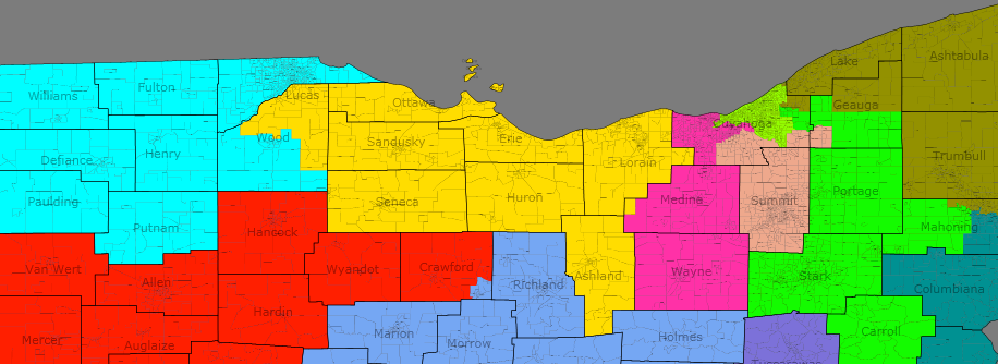
Texas redistricting is the big prize on offer in 2010 state elections. Both sides have strong motives to want control, quite aside from the fact that it’s got 32 seats already and will probably have 36 next time round. Democrats, still smarting from Tom DeLay’s mid-decade shenanigans, would love to control the maps, allowing them to take advantage of rapid Hispanic growth and perhaps to draw a district for a longtime conservative state legislator who can scrabble out enough of a foothold to keep himself afloat with rural whites for another few years.

Republicans want to maintain their huge edge and to fix elements of the Delaymander that are falling apart – districts like TX-32 and TX-10 where a changing population will draw the ground out from under the Republicans by 2020. They also don’t want to see a return to the 1991 Democratic gerrymander.

My impression is that Republicans have the edge, so I’ve drawn a gerrymander for them. However, with Democrats controlling the Justice Department, minority rights will have to be respected. Texas Republicans cannot just draw four new districts for white Anglos, or the map will be thrown out.

Dave’s Redistricting App estimates Texas’ population as being 54% white, 11% black, 4% Asian and 31% Hispanic.

That ought to shake out to four black-majority districts, but the population just isn’t packed enough for that to be possible. I’ve kept the three districts that are already designed to elect black representatives, although they’re all black-plurality rather than black-majority. Two are at 47% black and are fairly safe, whilst the other is 38% black and may be Hispanic-plurality by 2020. That said, it’ll still probably elect a black representative from there for years afterward.

You can’t draw an Asian district, although in Houston an Asian-influence district might just be possibility come 2020. That leaves us with Texas’ 7.8m Hispanics. That ought to equate to 11 Hispanic-majority districts. I tried to do that and preserve a GOP gerrymander, but the numbers aren’t quite there. Instead I got 10 and an Austin district, where Doggett could easily be succeeded by a Hispanic.

In the meantime, I think I preserved a GOP gerrymander fairly well. There are 24 districts McCain won and in 20 of those he got 60% of the vote or more. In only one Republican did McCain get less than 58% of the vote.
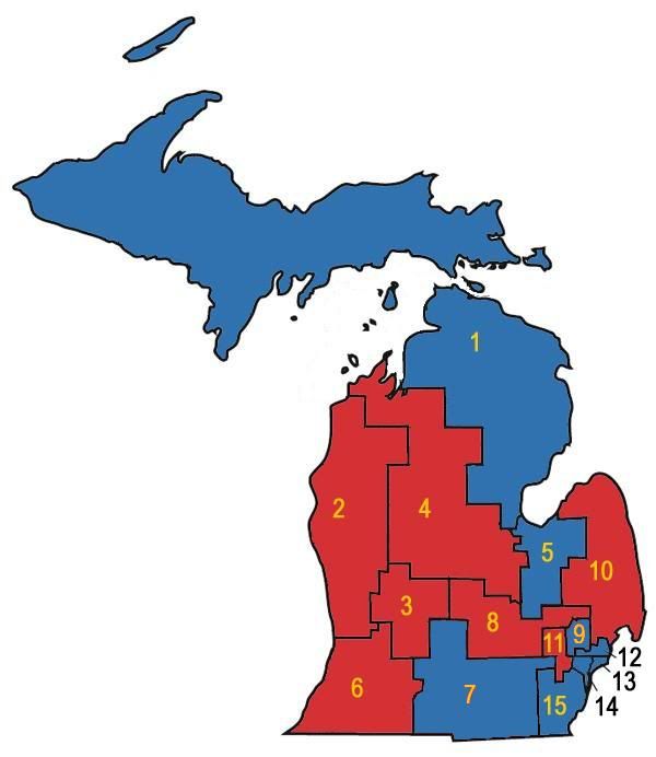
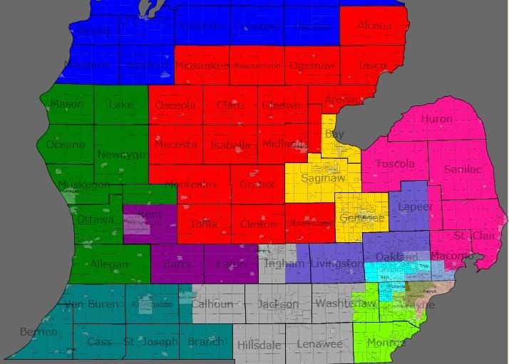
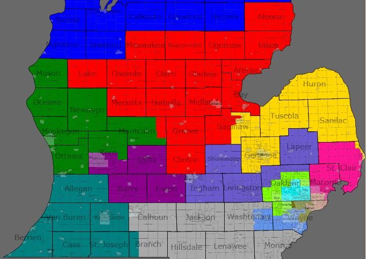
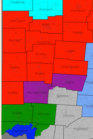
[Map]

West Texas

TX-01 – blue

[Demographics]

Obama: 65 McCain: 34

Likely candidate: Silvestre Reyes

First things first: yes, I’ve renumbered the districts. This is partly because I started in west Texas, headed east to the sea then spiralled clockwise round the state, finishing in the Houston suburbs and was too lazy to swap the colours later. But it’s also partly because there’s almost no rime nor reason to Texas’ current numbering system, so I don’t see the urgent need to change.

Reyes’ district shrinks slightly as El Paso grows. The district gets negligibly less Democratic, but I don’t think he’s going to be quaking in his boots.

TX-02 – dark green

[Demographics]

Obama: 62 McCain: 37

Likely candidates: Henry Cuellar, Ciro Rodriguez (?)

This district covers the Mexican border from El Paso to Zapata county and clocks in at a hefty 81% Hispanic. It looks an awful lot like Ciro Rodriguez’s current district, only straying into some south-eastern (and not entirely Hispanic) outskirts of San Antonio.

On the flipside, it now contains Laredo. Cuellar won the last primary, and as the Democratic primary will be the decider, I wouldn’t bet against Republicans crossing over to support him. I’m not even certain whether Ciro lives in this district, but either way he might consider running in the new third instead, except for one thing…

TX-03 – dark purple

[Demographics]

Obama: 38 McCain: 61

Likely candidates: Mike Conaway (?), Ciro Rodriguez (?), Henry Bonilla (?)

Democrats have always been keen on the idea of a Hispanic-majority West Texas seat. This seat gives it to them, just, but in a form they can’t win. The core of the old 11th around Midland is here, but rather than taking in San Angelo and the Hill Country, the district instead dives south-east to take in central San Antonio.

Although Hispanics make up 50% of the district’s population, many of them can’t vote (and plenty of the more rural ones are quite conservative) so McCain beat Obama by 50,000 votes here.

The flip-side of this is that the district is guaranteed to swing left, as rural west Texas depopulates and Hispanics become eligible to vote. Right now around 40% of the district’s inhabitants (and 60% of its Hispanics) live within Bexar county.

Given that trend, Conaway might decide to give the new 3rd a miss and move to the 10th, which northern bits of Midland protrude into. Who could step into the breach for the GOP? A Hispanic candidate would help, although primary voters might not warm to him. How about Henry Bonilla?

TX-09 – light blue

[Demographics]

Obama: 39 McCain: 60

Likely candidates: ?

This is essentially a Hill Country and Colorado River watershed district. A few almost uninhabited counties aside, the district is anchored in the west by San Angelo and bits of Austin and its suburbs in the east.

The rest of the district is largely rural, with Brady probably the largest town outside Travis and Tom Green counties. I’m not sure who the GOP would pick to run here, but I’d put good money he’d try to grab a seat on the agriculture committee.

TX-10 – magenta

[Demographics]

Obama: 34 McCain: 65

Likely candidates: Mike Conaway (?), Chet Edwards (?)

Now that Charles Stenholm is busy with lobbying, there’s much less need for Republicans to draw three blood-red districts in west and north-west Texas. Instead I’ve created a series of strips heading east-west and reaching into Central Texas in an attempt to combine ultra-Republican West Texas with very Republican Central Texas.

This district is a two county tall line through West Texas, taking in north Midland, Big Spring, Sweetwater and Abilene amongst others before abruptly turning south-east. From there it extends just far enough to take in Killeen and half of Waco.

If Mike Conaway decides he’s too crazy to feel safe representing a majority-Hispanic district, he might run here. Otherwise there are plenty of local legislators willing to step up. The district contains 170,000 (mostly Democratic) voters from Bell County, 130,000 from McLennan County and 110,000 from Abilene. So whether the primary winner would be from Killeen, Waco, Abilene or even somewhere further west is an open question.

Either way, I can’t see Chet Edwards running here. Depending on which side of Waco he lives on he might be resident here and he’d like to represent Fort Hood again, but the only bit shared between this district and the current TX-17 is western McLennan county. He won’t want a district that borders New Mexico.

South Texas

TX-04 – red

[Demographics]

Obama: 69 McCain: 31

Likely candidates: Ruben Hinojosa

McAllen is big enough for its own district now. I made up the numbers with south-eastern Hidalgo county, including Hinojosa’s hometown of Mercedes.

At 88% Hispanic, almost certainly the US’ most Hispanic district.

TX-05 – yellow

[Demographics]

Obama: 63 McCain: 36

Likely candidates: ?

An amalgam of the current 28th, 27th and 15th districts, this district takes in Brownsville, Herlingen, Kingsville and a lot of thinly populated rural areas. No current representative lives here, although Solomon Ortiz might move if he doesn’t like the 6th. Either way, he’ll surely face a primary from a local boy.

TX-06 – teal

[Demographics]

Obama: 44 McCain: 55

Likely candidate: Solomon Ortiz

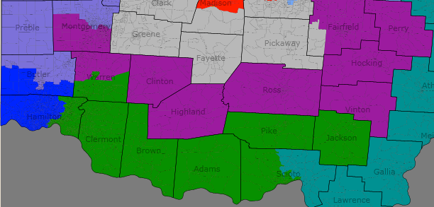
This district begins near Corpus Christi and continues along the coast as far as Jackson and Calhoun counties. To this it adds a fairly Hispanic hinterland of counties a little further inland. So far, so understandable.

However, it then sends a dogleg north-east to pick up enough of southern Bexar county (including south-central San Antonio) to make it Hispanic-majority.

I tried to clean up the dogleg both to improve Republican prospects and to make it look less like an obvious gerrymander, but it can’t really be hidden.

At 54% Hispanic it’s less vulnerable on voting rights grounds than the 3rd, but if Solomon Ortiz runs here expect him to involve the courts.

Either way, of course, Republicans will be finding it difficult by 2020, especially if they’re still chasing the nativist vote. Still, this could be a pick-up in 2012 with a decent candidate.

[San Antonio map]

TX-07 – grey

[Demographics]

Obama: 58 McCain: 41

Likely candidate: Charlie Gonzalez

This district isn’t radically changed from the old TX-20. It continues to be a metro San Antonio district with a Hispanic majority, although not as much of one now that so many other districts have taken bites out of the city.

Still, at 54% Hispanic I don’t see Gonzalez having too many problems winning re-election.

TX-08 – light purple

[Demographics]

Obama: 44 McCain: 55

Likely candidate: Lamar Smith

The northern bits of the old TX-21 are removed for this district so that it’s made up of majority white sections of northern San Antonio as well as western Guadalupe county and the counties north of Bexar.

Smith might be in trouble if Hispanics if northern San Antonio rapidly gets more liberal or more Hispanic, but as the district is at 63% McCain right now he ought to be able hold them off for a few years yet.

North Texas

TX-11 – light green

[Demographics]

Obama: 29 McCain: 70

Likely candidate: Randy Neugebauer, Chet Edwards (?)

Now that Charlie Stenholm is no more, you could make Neugebauer’s turf into a more reasonably shaped district. Or you could just use it to annoy Chet Edwards. Guess what I did?

This district begins in the Llano Estocado around Lubbock and heads east along county lines until it hits the Metroplex exurbs. It extends as far as Mineral Wells but afterwards turns south and south-east, shadowing my TX-10. It gets as far as McLennan County, taking in eastern Waco, before the district reaches its population complement.

This district is more like Chet Edwards’ than TX-10. It includes around 180,000 of his current constituents and all or part of four counties he represents (Hood, Somervell, Bosquet and McLennan). On the other hand, 75% of the district is new, it voted for McCain by forty points, it borders New Mexico and he may not even live here. If he runs here, he’s a brave man.

TX-12 – metallic blue

[Demographics]

Obama: 24 McCain: 75

Likely candidate: Mac Thornberry

I really tried to minimise the pain amongst Texas Republicans by spreading it evenly. That’s very difficult to do with TX-12.

Any district beginning in the Panhandle has a long way to go before it hits an area of demographic strength. What’s more, it has to go through the northern exurbs of the Metroplex, which are solidly Republican and heavily populated.

If I’d gerrymandered a little harder, I could have got this district to Fort Worth. But even then, it’d still be a 70% McCain district, so why bother?

Instead I just chucked all the Panhandle into the district then marched the district along the counties bordering Oklahoma, before turning south to pick up northern bits of Denton County.

TX-13 – terracotta

[Demographics]

Obama: 38 McCain: 61

Likely candidate: Kay Granger (?)

Whilst Kay Granger could run here, she’d work just as well in TX-23 (although it is slightly more marginal) and has no pressing need to move. It’s more likely that this will be filled by new blood. Whether it’s a hard-right suburbanite or a a hard-right exurbanite is the major question here.

Arguably this isn’t a North Texas district but a DFW district. Whilst the bulk of its geographical area is made up two counties west (Park and Wise) and two south (Hill and Johnson) of the metroplex, it sends an arm into Tarrant County, picking up south-eastern Fort Worth and central Arlington. Nearly half of the district lives in this arm.

Yet whilst the 325,000 people within Tarrant County in the district are only 45% white and voted for Obama 58-41, the rest of the district is 85% white and went for McCain 75-24. So long as the margin in the rural/exurban sections remains so lopsided, this’ll stay safely Republican and it’ll behave like a North Texas district.

If the Tarrant County section starts to dominate or if the outlying areas start to moderate, things will get closer. But even if it’s looking a bit ropy come 2020, it’ll likely take a wave year to flip it.

Incidentally, Chet Edwards currently represents the two southern counties of this district. However, I can’t see him running here because a) he doesn’t live here and b) I’m not convinced he’d win the primary. He currently represents less than 30% of the district’s residents and those two counties have less than 20% of TX-13’s Democrats. I just can’t see black and Latino voters in Fort Worth and Arlington (who’ll likely be decisive in the Democratic parimary) deciding that the representative they really need is a conservative white guy from central Texas.
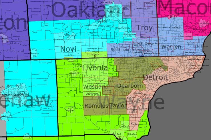
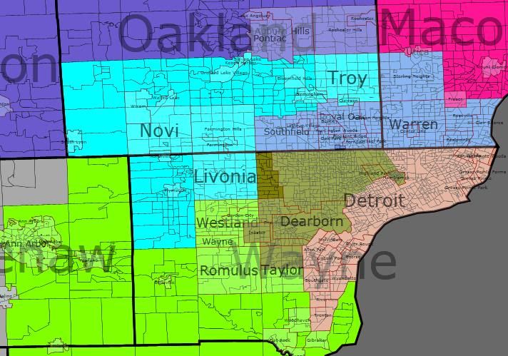
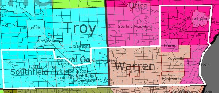
DFW Metroplex

[map]

TX-14 – greenish brown

[Demographics]

Obama: 38 McCain: 61

Likely candidate: Michael Burgess

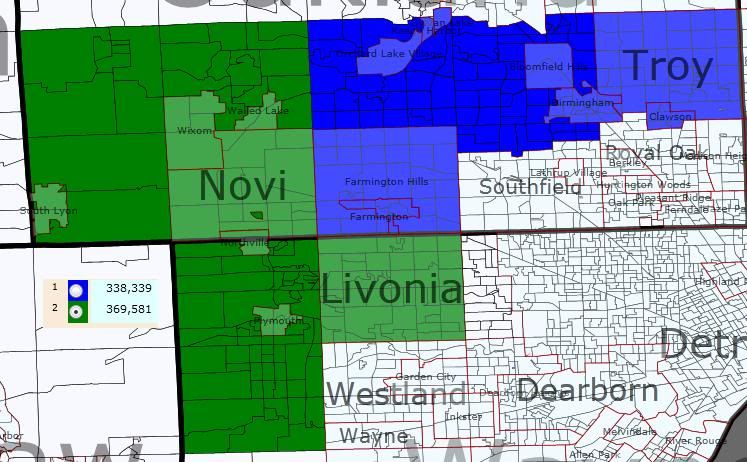
Population growth shrinks this county heavily. The old TX-26 gives up its portion of Tarrant County, splitting it beween TX-13, TX-21 and TX-23, and its spur into Cooke county joins north Denton in TX-12.

On the other hand, it takes over south-east Denton from the old TX-24 and extends across the border into Collin County, picking up Frisco and the eastern fringes of McKinney.

Burgess’ margins improve 6 points net from 58-41.

TX-15 – orange

[Demographics]

Obama: 37 McCain: 61

Likely candidate: Sam Johnson

TX-15 could be entirely confined to Collin County, but I’ve decided not to so as to give myself a little more freedom.

Which is not to say that it’s not a Collin County district – the Dallas County part of the district contains less than 4% of its inhabitants. More specifically, it’s a Plano-McKinney district, and around 9 points more Republican net.

TX-17 – dark blue

[Demographics]

Obama: 61 McCain: 38

Likely candidate: Pete Sessions (?)

No, this isn’t really Pete Sessions’ intended district, but it might be the one where he actually lives, as I can’t work out which bit of Dallas he lives in. If Pete can win a district that’s only 30% white, then I’m a gazebo. If he lives here, he’ll move, probably to TX-20. That said, TX-20 is probably more likely to include his home anyway.

(Yes, I did draw these districts before checking where each incumbent lives. Nevertheless, in general I got away with it – DFW is a slight exception and even there it’s clearable.)

As it is, this is the Metroplex’s new Hispanic district. I have no idea who the likely new incumbent would be here.

TX-18 – slightly pale yellow

[Demographics]

Obama: 79 McCain: 20

Likely candidate: Eddie Bernice Johnson

The basic shape of the district isn’t changed enormously and it remains a plurality-black district. In fact, it’s now blacker than it used to be, up from 42%. That said, I couldn’t find any way of getting to 50%.

TX-19 – grassy green

[Demographics]

Obama: 39 McCain: 60

Likely candidates: Joe Barton, Chet Edwards (?)

This district begins in south-western Tarrant and south-eastern Dallas county, but only to absorb swing whites in the area within a much redder district. From there’s it’s a long strip south-south-east through Barton’s base in Ennis county, Navarro, Limestone, Freestone, Roberton and north Brazos (including Bryan and College Station).

This isn’t wildly dissimilar to Barton’s current district, which differs mostly in that it turns east at Freestone and in that it includes more of the Metroplex.

If Chet Edwards doesn’t require, here’s probably his best bet to challenge, as the southern half of the district is pretty familiar to him. That said, Barton is pretty well-embedded in the district and we can’t assume Edwards will win any district just because it’s slightly less Republican than his current one.

TX-20 – salmon pink

[Demographics]

Obama: 41 McCain: 58

Likely candidates: Pete Sessions, Ralph Hall

There was no active need to screw Ralph Hall over in this map, but I don’t think that’s inherently unlikely in a Republican gerrymander. There are several reasons for this.

Firstly, he’s 86 and plenty of ambitious state legislators in North-East Texas would like to see him retire so they can replace him. Secondly, his committee assignments aren’t crucial to Texas – his seniority on Energy and Commerce is considerable, but Joe Barton is already ranking member and is 26 years younger, whilst Science and Technology is a relatively minor committee with a lot of Texas Republicans on it, including Lamar Smith as the third in seniority. Thirdly, Hall used to be a Democrat and whilst he’s effectively been a Republican since he joined Congress, he’s still not the member they most want to protect.

None of this means he will be drawn out of his district. Rockwall County could join the new TX-16, although it’d require a lot of shifting around amongst the DFW districts. Nevertheless, it’s questionable whether Hall will be running for re-election in 2012, so I’ve drawn Rockwall into the new TX-20.

The rest of the district is made up of northern and north-eastern Dallas County, including Richardson, Rowlett, Addison, University Park, Highland Park, bits of Garland and much of north Dallas. A lot of this is already represented by Pete Sessions and whilst a district extending into Rockwall instead of Irving might be new, it shouldn’t pose a challenge. And Ralph Hall certainly shouldn’t, as this much more Sessions’ district than it is Hall’s.

TX-21 – reddish brown

[Demographics]

Obama: 39 McCain: 60

Likely candidate: Kenny Marchant

This district no longer includes the Denton county portions of Carrolton, but otherwise Marchant has no reason to complain. Although he does pick up a fair amount of black voters near the Fort Worth-Arlington boundary, his new district went by McCain by over twenty points.

What’s more, the new district is a lot less likely to slip away from under his feet than the last one. Now that the southern part of the old TX-24 is gone, Marchant represents the third least Hispanic district of all Texas’ predominantly urban districts (beaten only by TX-14 and TX-15 just to his north). It’s therefore unlikely that increasing Hispanic eligibility to vote will cut his margins as much as will happen elsewhere.

TX-23 – very light blue

[Demographics]

Obama: 42 McCain: 58

Likely candidate: Kay Granger

The last district wholly within the Metroplex is also the one Republicans will be most wary of. It includes the bits of Tarrant Granger already represents plus a little more on central Fort Worth. Of course, that kind of reduction in size tends to betoken population growth. And this being Texas, population growth means Hispanics.

At 24% Hispanic,  TX-23 could become quite hairy by 2020. Unfortunately there’s no obvious way to avoid this – Fort Worth doesn’t have a huge amount of monolithically Hispanic neighbourhoods, and some of them have been dropped into TX-13, but it has enough of them scattered in every area for it to be hard to minimise Hispanics.

Therefore, Granger may have to play up her moderate bona fides. Maybe she’ll hold it, maybe she won’t. A lot will depend on how much she can cut Democratic margins amongst the Hispanic community.

East Texas

TX-16 – bright green

[Demographics]

Obama: 29 McCain: 70

Likely candidate: ?

This is basically Ralph Hall’s district minus Ralph Hall. A few lines are straightened up, it grabs a couple of small counties and now only splits Collin County, but nothing to write home about.

However, without Rockwall in the district it’ll lack an incumbent, so expect a free-for-all in the Republican primary. Just don’t expect any Democrat to stand a chance in the general.

This is a district so red I really should have worked out a way to send it into Tarrant to help out Granger.

TX-22 – muddy brown

[Demographics]

Obama: 35 McCain: 64

Likely candidate: Jeb Hensarling

This is in some ways a Dallas district, as it provides more than a third of the district’s population and is the biggest contributor to the total by some margin. Certainly the district’s centre of gravity lies in the suburban and exurban parts of the old TX-5.

On the other hand, to the core of that district I’ve added a bunch of thinly populated East Texas counties reaching down towards Dallas. Whilst it’s not going to be enough to worry Dallas resident Hensarling about a possible primary, it does keep the district nice and red and provides it with a potential out into a future existence as a proper East Texas district when overwhelmed Republican districts start to have to flee DFW in 2020.

TX-24 – very dark purple

[Demographics]

Obama: 31 McCain: 69

Likely candidate: Louie Gohmert

What can I say here? Like TX-16, the changes are not major. Three counties to the north are lost and in return most of Cherokee county is taken. Had I not been playing to strict population equality rules – no more than 1000 plus or minus than the average – I’d have taken the entire county and created a district that actually looks naturally shaped.

Either way, it’d still be a monstrosity for Democrats and a sinecure for Gohmert.

TX-25 – dark pink

[Demographics]

Obama: 34 McCain: 65

Likely candidate: Ted Poe (?)

This was originally designed as a fairly pure South-east Texas district. Although population equality necessitated a move out of that area, I had hoped to do it just by hopping Galveston Bay and grabbing most of Texas City.

Then I checked and found out Ted Poe lives in Humble. After deciding it wasn’t practicable to essentially swap Brady and Poe into each other’s districts, I then had to abandon the Galveston Bay hop and head into Harris County, necessitating a fair bit of boundary reworking between this district, TX-26 and TX-31. That and the need to keep TX-31 as black as possible account for most of the very ugly lines in north Harris, with population equality causing the rest.

Nevertheless, South-east Texas still predominates here, as less than 25% of voters are resident in Harris county. Indeed, Ted Poe still might not live here, as I only included about two-thirds of Humble. Poe isn’t completely immune from a challenge emanating from Beaufort or Port Arthur.

Either way though, Republicans are heavily favoured.

TX-26 – dark grey

[Demographics]

Obama: 26 McCain: 73

Likely candidate: Kevin Brady

My initial plan called for this seat to be based around Montgomery County, heading down into Harris to pick up some northern outliers of Houston.

Having to draw Ted Poe back into TX-25 screwed that up, especially as a lot of the north Houston suburbs ended up being needed for Sheila Jackson-Lee’s district.

Instead the district limits itself to only a few forays over the Harris-Montgomery line and instead heads eastward to take in San Jacinto, Polk and Tyler counties. These appear to be fairly standard East Texas counties and are thus quite different from rapidly growing Montgomery county, but the culture clash shouldn’t be a problem for Brady, as he already represents everything in this district bar the portions of Harris.

At 73% McCain, this is a very safe district.
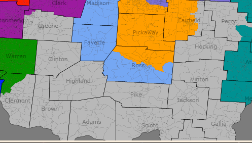
Central Texas

TX-27 – emerald green

[Demographics]

Obama: 40 McCain: 59

Likely candidate: John Carter

I’m skipping over Houston for now and heading straight on to central Texas. Except of course that I’ve mostly done central Texas using the tendrils of TX-10, TX-11, TX-19 and TX-22.

In practice, therefore, I’m left with only three districts. Once you exclude the metro Austin one, you’re left with two and this is the only one that makes a concerted effort to stay within the area’s borders.

I can’t say I’m entirely happy with it. I’d hoped to make Carter safer than this, but screwing over Chet Edwards sucked up many of the reddest bits of central Texas and the southern parts of this district aren’t quite as Republican as Erath, Hamilton and Correll counties, which have been removed.

That said, this district isn’t a disaster. Williamson and Bell counties are getting bluer, but this bluening is not necessarily permanent and is in any case balanced out by my removal of Killeen from the district and the much more rural eastern end of the district.

Carter might not like this district, but he can win it, as it voted for McCain by around 3% more than the rest of Texas. Even in 2020, it’s unlikely Texas will be much more than a swing state and much of that change will be driven by Hispanics, who aren’t a massive factor here.

Carter or his successors just have to hang on for five more terms, by which time Chet Edwards will be long gone and a central Texas district staying further away from Austin can be drawn.

TX-28 – light purple

[Demographics]

Obama: 72 McCain: 26

Likely candidate: Lloyd Dogget, Mike McCaul (?)

Splitting Austin was a cute idea, but realistically an over-ambitious one. Since Republicans have failed to eliminate Lloyd Doggett that way, they’re better off giving him a metro Austin district. That way they can run against Austin liberals in the event of San Francisco falling into the sea and can also sit back and hope he falls victim to a race-based primary.

Northern and eastern portions of Austin were included in TX-9 to bulk up the numbers and the Travis county bit of Round Rock joins Pflugerville in TX-27, but otherwise Travis County belongs to this district.

No Republican is going to win here, so Michael McCaul should move.

TX-29 – dull green

[Demographics]

Obama: 38 McCain: 61

Likely candidate: Michael McCaul (?)

This would be a good place for McCaul to move, as no other congress-critter lives here and it’s Republican by quite a significant margin.

That said, it doesn’t include much of his previous district. Both the old TX-10 and the new TX-29 are Austin to Houston districts, but the old version took a rather more northerly route. Only two counties – thinly populated Austin and Waller – are found in both districts in their entirety – whilst the three other counties where some ground is shared still don’t bring the shared areas above 100,000 people.

On the other hand, Mike McCaul cannot win a minority-majority Austin district, and this is the only nearby district without an incumbent.

McCaul’s problems don’t stop there, however. Whilst the district goes from the Travis County border to take in one voting district from Harris County, it also extends south to the Gulf of Mexico. In the east it takes in half of Fort Bend county, including the lion’s share of Rosenberg and in the south-east it picks up heavily Hispanic areas towards San Antonio, including San Mateo and Seguin.

The district’s 31% Hispanic population poses a ticking timebomb for McCaul. Prboably not one that will get him by 2020, although by then it’ll be a minority-majority district. But certainly one that will make him difficult to protect come the next redistricting.
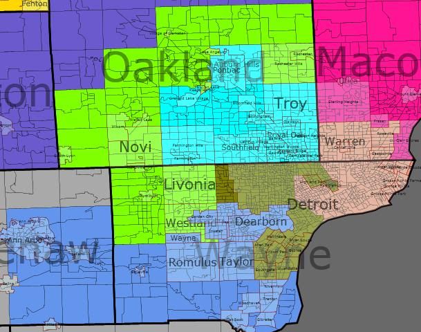
Houston

By what margin will Bob Shamansky win?

View Results

Loading ... Loading ...

Contest Entry: New York 28-0

Overall Plan

This entry in the redistricting contest creates 28 Democratic seats and 0 Republican seats. I expect Peter King to lose against Carolyn McCarthy, Chris Lee to lose against Brian Higgins, two Democrats to win in new districts, and one of Scott Murphy or Bill Owens to lose in a primary.

I aimed for compact districts, by and large. Some districts stretch this a little (e.g., 16 and 18), but most are more compact than they used to be. There are no earmuffs like NY-26. There are no water connections over uninhabited islands like NY-08. There’s no connecting through a Con Ed plant to pick up population from Rikers Island like NY-15. Perhaps the only cheap trick was connecting the new Velázquez district through Prospect Park. I even refrained from drawing a thin tendril from Meeks’s district to King’s house.

I was very careful to ensure that a representative actually lives in a district if I assert that I’m drawing a district for him or her. This was rather constraining in several cases. However, I avoided relying on incumbency to keep districts safe, since most of the NY delegation will retire before the next round of maps goes into effect in January 2023.

Along a similar line, I tried to keep Democratic incumbents with at least some of their base of support. For example, since Massa’s current district runs to the Rochester suburbs, I kept it that way rather than giving him some kind of Buffalo-based or Binghamton-based creation. (But when an incumbent, such as Slaughter, has two very distinct bases of support, I only aimed to keep one of them – in Slaughter’s case, it was Rochester rather than Buffalo.) Our incumbents have worked hard to build relationships with local leaders and activists in their current districts, and I’d rather not take that away from them.

All districts are within 100 votes of the target population, except for the three westernmost districts, which are within 200.

Photobucket

Photobucket

Photobucket

Districts by Geography

On Long Island, I’ve reconfigured the two Suffolk districts into an east-west alignment to even out the Democratic advantage between them. In Nassau, I’ve carved King’s district up between Ackerman (whose district is now almost entirely outside the City) and McCarthy, and placed some Republican areas along the NYC border into Meeks’s and Weiner’s districts.

Photobucket

In Queens, Meeks’s district is roughly the same as before, although it now encompasses some Black and Republican areas in Nassau and Brooklyn. Weiner’s district is still based in Forest Hills, but now spills eastward towards Nassau rather than westward into Brooklyn. Lowey’s new district reaches down into Whitestone. Crowley’s district has been consolidated into a compact area of western Queens, and Maloney still has about the same area.

Photobucket

Most of Brooklyn is in VRA districts. Velázquez’s district is heavily Democratic, since I found that I had to use almost entirely Democratic precincts in order to build a 48% Hispanic district. However, I found that it was easy to build solidly Democratic 50% Black districts that had spare capacity to take on Republicans from southern Brooklyn. Therefore, most of southern Brooklyn is divided among the 50% Black VRA districts of Meeks, Towns, and Clarke. Most of the remainder (White Democratic areas like Brooklyn Heights and Park Slope) goes to Nadler, while McMahon and Maloney each represent small areas near the cores of their districts.

Photobucket

Staten Island is in McMahon’s district. If McMahon were to lose in 2010, I would want to split the island across two safely Democratic districts.

Lower Manhattan is split between McMahon (who needs the Democratic votes) and Nadler. Midtown and Uptown up to about 96th are split between Nadler and Maloney, as is roughly the case today. Harlem is still in Rangel’s district.

Photobucket

In the Bronx, Serrano’s district is substantially similar to its current form, although Rangel and Engel both get some of his current Democratic Hispanic votes. The rest is split among two of the districts districts that extend up into Westchester and beyond.

Photobucket

I have divided the northern Metro Area into four districts. Two (Engel and Lowey) have significant Democratic populations from New York City, which allows Engel to take Republican precincts from further Upstate. Hall also extends through Democratic areas nearly to NYC, which allows him to take Republican precincts from further Upstate as well. In particular, Rockland County is carefully divided between Republican precincts (which go to Engel) and Democratic precincts that can be used elsewhere. This allows me to create a fourth new district in the Hudson Valley, which goes from Poughkeepsie down to New City.

Photobucket

I split the Capital Region into two districts, one for Tonko and one for either Murphy or Owens. I judged Owens’s current district too tenuous to maintain in its existing form, so I split the North Country into three parts to attach to Maffei’s, Arcuri’s, and Murphy or Owens’s districts.

PhotobucketPhotobucket

In Central New York, Utica and Syracuse each have one district. Binghamton also has a district, which extends eastward to Kingston and Middletown, as it does today. However, I transferred Ithaca from Hinchey to Arcuri in order to solidify Arcuri.

Photobucket

After the 2000 Census, the redistricters drew four districts for Western New York, intending to have them split 3-1 Republican. Their map connected parts of Rochester and Buffalo along a narrow strip to create a packed Democratic district, and then splintered the remaining Democrats among three other districts that they intended for Republicans. However, the four-district region as a whole leans Democratic, so one can create four Democratic districts just by giving each of the four districts an equal number of Democrats. In order to prevent Lee from stealing a district, I’ve put his residence into Higgins’s district and have drawn the incumbent-less district so that it has more Democrats than the other three.

Photobucket


District Summaries

NY-01

Incumbent: Tim Bishop (D) lives in precinct Southampton 6.

Population: 700259

Population % by Race
Wh Bl Hisp Asn Nat Oth
75 6 15 2 0 2
Presidential Voting
New Old 1
Obama % 53.91 51
McCain % 45.56 48

Description: District 1 covers the southern half of Suffolk County, from Brentwood and Central Islip out to the Hamptons. It omits a strip of Republican land along the beach opposite Jones Beach and Fire Islands.

The current NY-01 was drawn to favor a former Republican incumbent, Felix Grucci, and contains all of Republican-leaning eastern Suffolk. In order to equalize the Democratic performance of Districts 1 and 2, I’ve reconfigured them so that each one gets a share of Republican-leaning eastern Suffolk. Thus, a large number of people from the North Fork are moving from NY-01 to NY-02, and a large number of people from the neighborhood of Brentwood and Central Islip are moving from NY-02 to NY-01.


Photobucket
Photobucket


NY-02

Incumbent: Steve Israel (D) lives in precinct Huntington 100 in Dix Hills.

Population: 700383

Population % by Race
Wh Bl Hisp Asn Nat Oth
81 8 7 3 0 1
Presidential Voting
New Old 2
Obama % 53.36 56
McCain % 46.49 43

Description: District 2 covers the northern half of Suffolk County, from Huntington and Commack, out through Coram to the North Fork.


Photobucket
Photobucket


NY-03

Incumbents: Carolyn McCarthy (D) lives in precinct North Hempstead 111 in Mineola; Peter King (R) lives in precinct Hempstead 36 in Seaford.

Population: 700386

Population % by Race
Wh Bl Hisp Asn Nat Oth
73 11 11 3 0 2
Presidential Voting
New Old 3 Old 4
Obama % 53.23 47 58
McCain % 46.04 52 41

Description: District 3 covers Democratic southwestern Nassau County (Hempstead, Garden City, Valley Stream, Freeport) along with a strip of Republican territory on the shore well into Suffolk County.

In 2008, King outperformed McCain significantly in his district, while McCarthy outperformed Obama modestly in her district. In an incumbent-incumbent race, I expect McCarthy to be able to win in a D-leaning district with 22% Black+Hispanic, particularly since about 2/3 of the district’s population comes from her old NY-04.


Photobucket


NY-04

Incumbent: Gary Ackerman (D) lives in precinct North Hempstead 99 in Roslyn Heights.

Population: 700388

Population % by Race
Wh Bl Hisp Asn Nat Oth
79 6 8 6 0 1

63

36

Presidential Voting
New Old 3 Old 5
Obama % 52.88 47
McCain % 46.35 52

Description: District 4 covers most of northern and eastern Nassau County, including Levittown, Hicksville, Oyster Bay, and Port Washington.

This coincides in large part with Peter King’s old NY-03. However, it also includes Democratic territory around Plainview and Port Washington, and it excludes the Republican shore. If King moved into this new district, he could conceivably pull an upset if Ackerman has forgotten how to run a competitive race. (This would be similar to how Tim Holden upset George Gekas in central Pennsylvania after they were thrown together in a Republican-leaning district.)


Photobucket
Photobucket


NY-05

Incumbent: Gregory Meeks (D) lives in precinct Queens 33-28 in St. Albans.

Population: 700255

Population % by Race
Wh Bl Hisp Asn Nat Oth
28 50 11 5 0 5
Presidential Voting
New Old
Obama % 78.94 89
McCain % 20.73 11

Description: As a VRA district, District 5 covers the Black areas of eastern Queens, St. Albans and Far Rockaway. It also covers several nearby Republican areas: the Five Towns, Rockaway Peninsula, and (through a connection across the Flatbush Ave. Bridge) Sheepshead Bay and Manhattan Beach.

This district achieves its required 50% Black population in southeastern Queens, and then uses its spare capacity to help achieve two goals: 1) It takes Republican votes from the Five Towns that might otherwise help King. 2) It helps break up the large White Republican sections of southern Brooklyn into irrelevant pieces. Currently, Weiner’s district achieves this second goal, but I prefer to use Weiner to inoculate Republican votes in Queens.

One more thing: For historical reasons, Section 5 of the VRA does not apply to Queens, only to the other three major boroughs. I think it would be a good thing to investigate whether Meeks’s district could be broken up to help out McCarthy and Ackerman against King. Meeks could still win a ~40% Black district handily. But maybe there’s a Section 2 thing that I’m not understanding?


Photobucket
Photobucket
Photobucket


NY-06

Incumbent: Ed Towns (D) lives in precinct 54-56 in East New York.

Population: 700355

Population % by Race
Wh Bl Hisp Asn Nat Oth
30 50 13 4 0 3
Presidential Voting
New Old 10
Obama % 79.82 91
McCain % 19.9 9

Description: As a VRA district, District 6 covers certain Black areas of Brooklyn (East New York, Brownsville, Canarsie, Flatlands). It also covers some nearby Republican areas around Gravesend and Brighton Beach.

This is another “Blacks and Republicans” district that achieves its required 50% Black population in one area, and then stretches out to White southern Brooklyn to split up the McCain votes there.


Photobucket


NY-07

Incumbent: Yvette Clarke (D) lives in precinct Brooklyn 43-78 in Prospect Gardens.

Population: 700389

Population % by Race
Wh Bl Hisp Asn Nat Oth
31 50 9 7 0 3
Presidential Voting
New Old 11
Obama % 79.31 90
McCain % 20.33 9

Description: As a VRA district, District 7 covers certain Black areas of Brooklyn (Bed-Stuy and Crown Heights). It also covers some nearby Republican areas, such as Mapleton and Bensonhurst.

This is another “Blacks and Republicans” district that achieves its required 50% Black population in one area, and then stretches out to White southern Brooklyn to split up the Republican votes there. Currently, Nadler’s district does this, but I prefer to make Nadler’s district less spectacularly gerrymandered than it is today.


Photobucket


NY-08

Incumbent: Nydia Veláquez (D) lives in precinct Brooklyn 72-100 in Carroll Gardens.

Population: 700328

Population % by Race
Wh Bl Hisp Asn Nat Oth
19 20 48 9 0 4
Presidential Voting
New Old 12
Obama % 88.22 86
McCain % 11.14 13

Description: As a VRA district, District 8 covers Hispanic areas of Brooklyn (Bushwick, some of Williamsburg, Boerum Hill, Sunset Park, and Kensington). It connects the two large Hispanic populations with a narrow strip through Prospect Heights and Prospect Park.

The Hispanic population of Brooklyn is barely large and concentrated enough to sustain a high-percentage district. Because of this, I avoided putting any nearby non-Hispanic areas in the district, such as Park Slope, Greenpoint, or the Republican sections of southern Brooklyn.


Photobucket
Photobucket


NY-09

Incumbent: Jerrold Nadler (D) lives in precinct Manhattan 35-67 on the Upper West Side.

Population: 700352

Population % by Race
Wh Bl Hisp Asn Nat Oth
52 11 18 16 0 3
Presidential Voting
New Old 8
Obama % 85.33 74
McCain % 13.85 25

Description: District 9 runs from the UWS, through Chelsea, and over to the LES. Then it crosses the Brooklyn and Manhattan Bridges, and covers several neighborhoods in Brooklyn: Brooklyn Heights, Park Slope, Red Hook, and Bay Ridge.

The Brooklyn portion of the district consists (by and large) of White Democratic neighborhoods. These are the neighborhoods that are not covered by the VRA districts.

I would ideally like to extend this district far enough down into Bay Ridge so that McMahon’s district would contain none of Brooklyn. However, it is difficult to do this and still have the district reach Nadler’s apartment on 70th St. In the end, I’m satisfied that McMahon’s district is sufficiently Democratic.


Photobucket
Photobucket


NY-10

Incumbent: Mike McMahon (D) lives in precinct Staten Island 61-35 on the northern part of the island (I don’t know neighborhood names).

Population: 700426

Population % by Race
Wh Bl Hisp Asn Nat Oth
72 7 11 8 0 2
Presidential Voting
New Old 13
Obama % 57.29 49
McCain % 41.95 51

Description: District 10 covers all of Staten Island, part of Bay Ridge in Brooklyn (connected by the Verrazano-Narrows Bridge), and the western half of Lower Manhattan (connected by the Staten Island Ferry).

The existing NY-13 was drawn to favor former Republican congressman Vito Fossella. A major goal of any Democratic redistricting should be to make this into a safe Democratic district. I accomplish this by adding a large portion of heavily Democratic Lower Manhattan. If there were a Republican incumbent, I would have split Staten Island into two pieces in order to guarantee the Republican’s defeat. However, that seems like overkill to shore up the seat for a sitting Democrat.


Photobucket
Photobucket


NY-11

Incumbent: Carolyn Maloney (D) lives in an unknown precinct on the Upper East Side (I’m assuming between 59th and 96th).

Population: 700270

Population % by Race
Wh Bl Hisp Asn Nat Oth
70 4 13 4 0 3
Presidential Voting
New Old 14
Obama % 77.09 78
McCain % 22.06 21

Description: District 11 covers the Upper East Side and Midtown East in Manhattan, Astoria and Long Island City in Queens, and Greenpoint and Williamsburg (the non-Hispanic parts) in Brooklyn. Although not visible on the Brooklyn map, the two sections of Brooklyn are connected by a couple precincts near the waterfront.

This district is very similar to Maloney’s current district.


Photobucket
Photobucket
Photobucket


NY-12

Incumbent: Charlie Rangel (D) lives in precinct Manhattan 70-31 in Harlem.

Population: 700336

Population % by Race
Wh Bl Hisp Asn Nat Oth
13 31 51 3 0 2
Presidential Voting
New Old 15
Obama % 93.62 93
McCain % 5.79 6

Description: District 12 covers Harlem (including Spanish Harlem) and Washington Heights, as well as a bit of the South Bronx. It has majority-minority (in fact, majority Hispanic) population.

Although this district has traditionally been considered a Black district, it is now majority Hispanic. There is a strong possibility of a Hispanic representative once Rangel retires or is driven out of office because of corruption.

I live in this district.

Photobucket
Photobucket


NY-13

Incumbent: Joe Crowley (D) lives in precinct Queens 30-45 in Woodside.

Population: 700405

Population % by Race
Wh Bl Hisp Asn Nat Oth
33 6 38 19 0 3
Presidential Voting
New Old 7
Obama % 71.26 79
McCain % 27.99 20

Description: District 13 covers several neighborhoods in Queens, including Jackson Heights, Corona, and Middle Village.

This district is quite different from the old NY-07, which reaches into the Bronx. I’m not sure why NY-07 has such a strange shape, and I see no good reason for it.

District 13 is a rare diverse district in the age of VRA-based segregation – no racial group exceeds 40% of the population. If Crowley retires in the coming decade, one could imagine a White, Hispanic, or Asian representative from this district. The Black voting population is actually slightly lower than 6%, since the district includes 8000 Black inmates at Rikers Island.


Photobucket


NY-14

Incumbent: Anthony Weiner (D) lives in precinct Queens 28-36 in Forest Hills.

Population: 700334

Population % by Race
Wh Bl Hisp Asn Nat Oth
41 8 19 24 0 8
Presidential Voting
New Old 9
Obama % 66.67 55
McCain % 32.64 44

Description: District 14 covers several neighborhoods in Queens. Starting at Howard Beach, it comes up through Ozone Park to Forest Hills, and then goes eastbound along the LIE to Little Neck. It also contains Great Neck in Nassau County, in order to isolate the Republican voters there from Peter King.

This district is more Democratic than the existing NY-09. That’s because the existing map uses NY-09 to fracture the Republican vote in southern Brooklyn. Instead, I use Meeks’s more heavily Democratic district to fracture Republicans in Brooklyn.


Photobucket
Photobucket


NY-15

Incumbent: José E. Serrano (D) lives in precinct Bronx 77-74 in the South Bronx.

Population:700362

Population % by Race
Wh Bl Hisp Asn Nat Oth
2 32 62 2 0 2
Presidential Voting
New Old 16
Obama % 94.60 95
McCain % 5.20 5

Description: District 15 covers the South Bronx, including the area just west of the Whitestone Bridge (Soundview?). It has a 60% Hispanic supermajority.

This district is substantially similar to the existing NY-16. However, it allows Engel to take some more Democratic votes from around Fordham campus.


Photobucket


NY-16

Incumbent: Eliot Engel (D) lives in precinct Bronx 81-67 in Riverdale.

Population: 700249

Population % by Race
Wh Bl Hisp Asn Nat Oth
53 14 26 5 0 3
Presidential Voting
New Old 17
Obama % 63.08 62
McCain % 36.26 38

Description: District 16 covers the northwestern Bronx (Riverdale, Kingsbridge, Bedford Park) and Yonkers. It then crosses the Hudson and picks up Republican areas along the New Jersey border in Rockland and Orange Counties.

Because this district gets so many Democratic votes from the Bronx and Yonkers, it can very selectively include only Republican voting districts in Rockland County. Many voting districts in Rockland County are either very Republican or very Democratic (possibly because of the separation of the Orthodox Jewish communities from other towns up there). As a result, the remainder of Rockland County can provide a core of Democratic votes for a district in the Hudson Valley. Obama lost District 16’s portion of Rockland County (134k population) by 16%, but won the remainder (167k population) by 23%.


Photobucket
Photobucket
Photobucket
Photobucket
Photobucket


NY-17

Incumbent: Nita Lowey (D) lives in precinct Harrison 10 near Rye.

Population: 700372

Population % by Race
Wh Bl Hisp Asn Nat Oth
43 23 21 10 0 3
Presidential Voting
New Old 18
Obama % 71.91 62
McCain % 27.53 38

Description: Within New York City, District 17 covers Whitestone in Queens and most of the eastern Bronx. It then continues along the shore (New Rochelle and Rye).

Nita Lowey used to represent parts of Bronx and Queens, and she can again. In compensation for taking away most of her current district’s population, I’ve given her a heavily Democratic district majority-minority district.


Photobucket
Photobucket
Photobucket


NY-18

Incumbent: John Hall (D) lives in precinct Dover 1 in Dover Plains.

Population:700344

Population % by Race
Wh Bl Hisp Asn Nat Oth
74 11 10 3 0 2
Presidential Voting
New Old 19
Obama % 58.07 51
McCain % 41.05 48

Description: District 18 starts in Democratic Mt. Vernon next to the Bronx, and snakes its way up through Democratic White Plains to rural Putnam and Dutchess Counties.

This district is heavily Democratic, without cutting into the Hudson Valley precincts that I need for the new Democratic-leaning District 19.


Photobucket
Photobucket
Photobucket


NY-19

Incumbent: None.

Population: 700376

Population % by Race
Wh Bl Hisp Asn Nat Oth
71 11 12 3 0 3
Presidential Voting
New
Obama % 58.20
McCain % 40.79

Description: District 19 lies in the Hudson Valley, including Poughkeepsie, Newburgh, Peekskill, and the Democratic portions of Rockland County. (See description of District 16 above.)

Although this district strongly favors Democrats at the federal level, there is no Democratic incumbent. Furthermore, the state legislators are all Republican, as are the mayors of Poughkeepsie and Newburgh. I believe that a Democratic non-politician along the lines of Hall, Murphy, or Owens would claim this seat. However, if the DCCC failed to recruit effectively, this district could fall to a local Republican.

Neither Sue Kelly (lost to Hall in 2006), John Sweeney (lost to Gillibrand in 2006), nor Jim Tedisco (lost to Murphy in 2009) lives in this district.


Photobucket
Photobucket
Photobucket


NY-20

Incumbent: Paul Tonko (D) lives in precinct Amsterdam city 1.

Population: 700342

Population % by Race
Wh Bl Hisp Asn Nat Oth
89 6 3 1 0 1
Presidential Voting
New Old 21
Obama % 54.49 58
McCain % 43.68 40

Description: District 20 contains part of the Capital Region, including Albany.

This district is slightly less Democratic than its predecessor. Most notably, it gives up Democratic Schenectady and Troy in order to make the new District 21 safer.


Photobucket
Photobucket
Photobucket
Photobucket
Photobucket


NY-21

Incumbent: Scott Murphy (D) lives in precinct Glens Falls 5; Bill Owens (D) lives in precinct Plattsburgh 3.

Population: 700425

Population % by Race
Wh Bl Hisp Asn Nat Oth
92 3 2 1 0 1
Presidential Voting
New Old 20 Old 23
Obama % 54.90 51 52
McCain % 43.41 48 47

Description: District 21 runs along the Vermont border, containing Schenectady, Troy, Saratoga Springs, and Plattsburgh.

The existing NY-20 and NY-23 were both created for Republican incumbents, and neither is particularly attractive to Democrats. Rather than contort district boundaries to preserve seats for both of these Blue Dogs, I prefer to carve up the moderate/Republican North Country to give safer seats to one of them and to Arcuri.

In a head-to-head primary, both candidates would have a reasonable chance of winning, since many of the Democratic votes would come from around Schenectady and Troy, which are presently in Tonko’s district.

Of course, there’s a real chance that one of these incumbents will lose in 2010. If that happens, then this district should favor the Democratic incumbent. Jim Tedisco (lost to Murphy) and Doug Hoffman (lost to Owens) both live in this district, but Dede Scozzafava (withdrew against Owens) does not.


Photobucket
Photobucket
Photobucket


NY-22

Incumbent: Maurice Hinchey (D) lives in precinct Hurley 3.

Population: 700380

Population % by Race
Wh Bl Hisp Asn Nat Oth
87 5 5 2 0 1
Presidential Voting
New Old
Obama % 53.24 59
McCain % 45.30 39

Description: District 22 contains Kingston, Middletown, Binghamton, and Elmira.

Giving Democratic Ithaca to Hinchey only makes sense if one is trying to pack Upstate Democratic votes in order to create Republican seats. This new district has enough Democrats from Binghamton and the Hudson Valley to be easily winnable.

Hinchey (born 1938) will probably retire during the next decade, and Republicans could make a play for this district in an open-seat election. However, the eastern part of the district is quickly becoming more Democratic (see Sue Kelly and John Sweeney), and I would expect Democrats to hold the seat.

Since the average district size increased by 4%, this new District 22 can span about the same amount of longitude without looking quite as goofy as the old NY-22.


Photobucket
Photobucket
Photobucket


NY-23

Incumbent: Michael Arcuri (D) lives in precinct Utica 4.

Population: 700382

Population % by Race
Wh Bl Hisp Asn Nat Oth
92 3 2 2 0 1
Presidential Voting
New Old 24
Obama % 52.62 50
McCain % 45.66 48

Description: District 23 contains Potsdam, Utica, and Ithaca.

Arcuri looked surprisingly weak in the 2008 election. However, with the advantage of incumbency and a district that’s a few percent safer, he should be able to hold his seat. He is one of the few Democratic incumbents who may stay in Congress until 2030.


Photobucket
Photobucket


NY-24

Incumbent: Dan Maffei (D) lives in precinct DeWitt 3 near Syracuse.

Population: 700338

Population % by Race
Wh Bl Hisp Asn Nat Oth
87 7 2 2 1 2
Presidential Voting
New Old 25
Obama % 55.45 56
McCain % 42.76 43

Description: District 24 contains Syracuse and Watertown.

This is the safest of the seats in the central part of the state. Its Democratic performance is similar to Maffei’s old district, but it crucially takes its non-Syracuse Democratic votes from the North rather than from the Rochester area. This allows the Rochester area to be split into Democratic-leaning districts.


Photobucket
Photobucket


NY-25

Incumbent: Eric Massa (D) lives in Corning city.

Population: 700395

Population % by Race
Wh Bl Hisp Asn Nat Oth
91 4 2 1 0 1
Presidential Voting
New Old 29
Obama % 52.64 48
McCain % 45.92 50

Description: District 25 is based in the Rochester area, containing the eastern part of the city, and most of the northeastern suburbs. It goes along the Lake Ontario coast as far East as Oswego, and also extends to the Finger Lakes Region (Auburn, Geneva, Canandaigua) and down through rural areas to the Pennsylvania border.

This district is much safer for Massa than the old NY-29.


Photobucket
Photobucket
Photobucket
Photobucket


NY-26

Incumbent: Louise Slaughter (D) lives in precinct Perinton 14 in Fairport.

Population: 700170

Population % by Race
Wh Bl Hisp Asn Nat Oth
80 12 5 2 0 1
Presidential Voting
New Old 28
Obama % 53.00 68
McCain % 45.73 30

Description: District 26 is also based in the Rochester area, containing the western part of the city and most of the suburbs. It contains rural areas (including Livingston and Allegany Counties) going South to the Pennsylvania border.

To create more safe Democratic seats in western New York, I give Slaughter’s Buffalo Democrats to the new NY-27 and give some of her Rochester Democrats to Massa in the new NY-25.


Photobucket
Photobucket
Photobucket


NY-27

Incumbent: None.

Population: 700157

Population % by Race
Wh Bl Hisp Asn Nat Oth
84 11 2 2 1 1
Presidential Voting
New Old 26
Obama % 54.55 46
McCain % 43.90 52

Description: District 27 is based in the Buffalo area, containing the northern part of the city, Niagara Falls, and rural areas to the North and East.

On a map, it may appear as though this district should “belong” to Lee, if he decided to move into it. However, only about 300k of the residents are part of Lee’s current district. Nearly as many (270k) are part of Slaughter’s current district, and the remainder are largely Democrats from Higgins’s district.

Because there is no Democratic incumbent here, I’ve made it the safest Democratic seat of western New York. If Lee did decide to run here, he would face a very tough district full of Democrats who don’t know him. Furthermore, Lee is not a strong candidate. Despite a bitter three-way Democratic primary in 2008 that produced a weak candidate, Lee barely managed to outpoll McCain in his current district.

Byron Brown (mayor of Buffalo) and Alice Kryzan (lost to Lee in 2008) live in this district. Jon Powers (lost in the primary to Kryzan in 2008) and Tom Reynolds (retired in 2008) do not. I don’t know about Jack Davis (lost several times).


Photobucket
Photobucket
Photobucket


NY-28

Incumbents: Brian Higgins (D) lives in precinct South 19 in Buffalo; Chris Lee (R) lives in an unknown precinct in Clarence.

Population: 700176

Population % by Race
Wh Bl Hisp Asn Nat Oth
85 8 4 1 1 1
Presidential Voting
New Old 27
Obama % 54.23 54
McCain % 44.11 44

Description: District 28 is based in the Buffalo area, containing the southern part of the city, the eastern and southern suburbs, and rural Chautauqua and Cattaraugus Counties.

Higgins would certainly beat Lee in an incumbent-incumbent matchup. A considerable majority of the population comes from Higgins’s old district, and the district leans safely to Democrats.


Photobucket
Photobucket
Photobucket

By what margin will Bob Shamansky win?

View Results

Loading ... Loading ...

2010 Texas Redistricting, a Democratic redistricting

After seeing all the great maps here I’ve decide to give it a try.  This is my first attempt at redistricting a state and my first diary.  While doing this for the first time I kind of wished I had lived in a smaller state, but Texas is where I grew up and where I live.  Since this is my first attempt at redistricting a state I want constructive criticism, but please be gentle 🙂 especially the long-time observers of Texas Politics because I am sure some of my commentary may be a bit off on some of the areas I am less familiar with.  I used Daves Redistricting App for this.  Please note I am not exactly familiar with the VRA law and how to apply it because I am new at this so if someone would like to critique this map for that it would be appreciated.

With Bill White running for Governor and the Democrats a few seats from the majority in the House, what would a Democratic Redistricting of Texas look like?

My goals for doing a Democratic redistricting of Texas were to

1.  Create at least two new Democratic seats in DFW

2.  Clean up Travis County

3.  Clean up Harris County, add another Dem seat.

4.  Work to weaken several GOP incumbents including Sessions and Culberson.

All districts have a +/- 2.5% population deviation from the average.  I will describe each group of district based on metro area or geographic location.

East Texas

CD-1 Largely consists of the currently existing CD-4.  Like most of rural Texas it is very white, very conservative. 71% White, 15% African American, 10% Hispanic  Safe R

CD-5 now includes Ellis County and the City of Tyler and is out of Dallas County entirely.  This new district has the potential for a very entertaining primary between Joe Barton, Louie Gohmert and Jeb Hensarling.  70% White, 10% African American, 16% Hispanic  Safe R

CD-6 which had a significant chunk of its population in the DFW metro area is now entirely rural.  69% White, 15% African American, 12% Hispanic.  Safe R

CD-17 although this district is in Central Texas it shows up good in the East Texas pic.  I am one of the people who remains amazed at Chet Edwards-D ability to hold on to his heavily GOP district.  Unsure of how to protect him I only have a few choices since his district gained population so Bosque, Somervell, Madison and Grimes Counties have been removed from his district.  Waco and Byran/College Station are still within CD-17  This district is probably still a Toss-up as Edwards will have to work hard to maintain this seat.  67% White, 9% African American, 19% Hispanic

Greater Houston Area (the Rural/Suburban districts)

CD-33 is a rural district which extends from greater Houston to Bastrop Country which is southeast of Austin  which is a solid GOP seat.  61% White, 11% African American, 25% Hispanic.  Safe R

CD-22 is now almost entirely contained within Fort Bent County with small pieces in Waller and West Harris County.  Obama barely lost Fort Bend County, and despite being a minority-majority district I think this seat stays GOP.  44% White, 17% African American, 24% Hispanic, 12% Asian  Likely R

CD-14 Ron Paul isn’t going anywhere.  56% White, 8% African American, 30% Hispanic.  Safe R

CD-08 contains north suburban Houston, the district is largely split between the fast growing Montgomery County and North West Harris County. 71% White, 5% African American, 16% Hispanic, 5% Asian.  Safe R

CD-02 Rural/suburban Houston contains Beaumont and Port Arthur.  62% White,, 18% African American, 15% Hispanic.  Safe R

Greater Houston (the Urban/Suburban districts)

CD-09 Now rests entirely within Harris County, other than a small extension to the west of CD-07 this district remains largely unchanged.  17% White, 32% African American, 36% Hispanic, 11% Asian.  Safe-D

CD-07 is now more Urban, it has essentially been shifted a big to the east which moves it a bit into south Houston.  The conservative west part of his district has been annexed by conservative CD-08.  46% White, 12% African American, 33% Hispanic, 5% Asian.  Leans D

CD-18 and CD-29 were both redrawn to undo the ugliness of the previous districts.  CD-18 15% White, 30% African American, 49% Hispanic.  CD-29 17% White, 14% African American, 65% Hispanic.  Both remain safe D.  

CD-35 Contains a good chunk of the currently existing CD-22 and is on the cusp of being a minority-majority district. 53% White, 10% African American, 29% Hispanic, 4% Asian  Lean R

Travis County (Austin)

CD-10 Contains most of Austin.  54% White, 6% African American, 32% Hispanic, 5% Asian,  Safe D

CD-25 At first I thought I drew a GOP leaning seat here but it may be a Dem leaning seat.  This district contains the remainder of Austin as well as Round Rock, Georgetown and Cedar Park.  If Dems organize well enough this could very well be a Dem held seat.  56% White, 9% African American, 27% Hispanic, 5% Asian.  Toss-up

Bexar County (San Antonio)

CD-21  This district is heavily Hispanic, much of this district is part of the former CD-23 and CD-20.  Ciro Rodriguez may opt to run here instead of CD-23 for reasons which will be clear when CD-23 is described. 29% White, 4% Black, 61% Hispanic  Safe D

CD-20  Central and South San Antonio, like CD-21 this district is heavily Hispanic. 30% White, 6% Black, 60% Hispanic  Safe D

South and Southwest Texas

CD-27 Remains largely unchanged, just tightened up because of the population increase in South Texas. 20% White, 2% African American, 75% Hispanic  Safe D

CD-15 Much of the Rio Grande Valley.  Safe D

CD-28 This guy extends from South San Antonio all the way down to Hidalgo county. 34% White, 6%, African American, 56% Hispanic  Safe D

CD-23 Laredo is back in this heavily Hispanic district.  82% Hispanic and 15% White makes this the most Hispanic district in the state.  

CD-16 In El Paso remains largely unchaged and is a bit more compacted.  Safe D

West and Central Texas

CD-13 A true West Texas district!  Contains the cities of Amarillo and Lubbock.  An interesting note about this district is that it is only 57% White, the remainder is 33% Hispanic and 5% African American.  I don’t know much about West Texas but I was expecting a much higher percentage of white folk.  However given the demise of the rural Democrats in Texas this district remains in the GOP hands.  Safe R

CD-19  Midland-Odessa and Abilene are the cities in this geographically huge district. 58% White, 5% African American, 33% Hispanic.  Safe R

CD-11  This one encompasses a lot of Lamar Smiths former CD-21.  San Angelo and part of New Braunfels make up this heavily GOP district.  Loving County which is also the least populous County in the Country is also here. 68% White, 2 % African American, 26% Hispanic.  Stonewall, the birth place of President Lyndon Johnson is in this district.  Safe R

CD-31  Another rural conservative district located in Central Texas. 64% White, 12% African American, 18% Hispanic.  Safe R

CD-04  Although this district is part of the DFW Metroplex it shows up nice on this image.  This district includes the northern parts of Denton and Collin County which are two of the fastest growing counties in the state.  At 78% White, 4% African American and 12% Hispanic this rural district is a GOP stronghold.  Contains Wichita Falls, Sherman and Denison, the later is the birthplace of President Dwight Eisenhower.  Safe R

DFW Metroplex

CD-36 This district which contains several Far North Dallas suburbs including McKinney, Allen, Frisco, Flower Mound and Denton is solid GOP all the way.  68% White, 7% African American, 17% Hispanic.  Safe R

CD-12  The C shape of this district obviously stands rightly for “conservative”.  The most conservative parts of Americas second largest conservative urban county are here.  Conservative parts of south and west Arlington, West and North Tarrant County lock up this district as a solid GOP seat.  Safe R

CD-26 Situated in Central Fort Worth extending out into south Fort Worth and west into Arlington.  The Democratic Party would lock this one up. 37% White, 21% African American, 37% Hispanic.  Safe Dem

CD-24 This guy straddles the Dallas-Tarrant County line and is in an area of Dallas and Tarrant County where local Democrats have been having a lot of success in state House races the past few cycles.  42% White, 14% Black, 34% Hispanic.  Lean D

CD-30  This was the sole Democratic Representative in DFW after the redistricting of 2003.  CD-30 does remain the most African American in the state, however the district now grabs the conservative enclave of Highland Park in near the center of Dallas county. 25% White, 38% African American, 32% Hispanic.  Safe D

CD-03  Another district where local Democrats have been having great success at winning State House Seats.  42% White, 16% African American, 33% Hispanic and 6% Asian.  I really want classify this seat as Lean D but I don’t think it is quite there yet.  Toss-up

CD-34  Now the “What…” moment will be answered regarding this creatively drawn district.  This district is drawn to strengthen the Democratic presence in CD-32 and CD-03 by moving a lot of the strong GOP north Dallas areas into a safe GOP seat with Plano.  CD-34 cuts straight down into Dallas County and ropes up University Park, a conservative enclave just north of Highland Park.  Plano is one of the most conservative cities in the country and is almost entirely within this district. 64% White, 7% African American, 12% Hispanic, 12% Asian  Safe R

CD-32  This majority Hispanic district is now ready for to be picked up by a Dem.  Heavily Democratic portions of south Dallas are included and heavily GOP sections of north Dallas are included in CD-34.  28% White, 11% African American, 54% Hispanic.  Likely D

By what margin will Bob Shamansky win?

View Results

Loading ... Loading ...

Democratic Debauchery in Colorado (Redistricting)

After a careful look at the state after coming up with a redistricting plan the first time around, I decided to be more aggressive, bringing the delegation to a possible 6-1 breakdown.  In another scenario I tried to create a majority Hispanic district, but while doable it makes a 6-1 breakdown impossible and would depose one of our current Democratic Reps.

I’m going off the assumption that Democrats retain both houses of the legislature and the Governor’s mansion, a tough fight but I think that’s how it’ll end up.  

This time the goals were to: A) Make Markey safe, B) shore up Salazar at least a little, C) Keep Perlmutter, Polis and DeGette in reasonably solid Districts, and D) transform one of the other 2 districts into a swing district.

Here’s a map of the result:

2010 Colorado Congressional Districts

And a look at the metro area…

Photobucket

1st CD: Diana DeGette v. Mike Coffman

Population: 706,016

58% White, 13% Black, 20% Hispanic

This district still retains a substantial Denver county presence, keeping DeGette’s home in east Denver, the Denver portion runs roughly from Elyria Swansea in the north, keeping Capitol Hill, Wash Park and all the neighborhoods north of I-25 up to Virginia Village, then everything east and south of that neighborhood is in the 7th.  Denver now makes up 38% of the district.

The 1st now includes all of Aurora, including the far-flung areas and Foxfield before going south into Douglas County, picking up most of Lone Tree and a good chunk of Parker.  It also manages to pick up Mike Coffman’s home, removing him from any Republican district.

Despite extending into Douglas county, only about 26% of the 1st is Republican leaning, with another 18% of the district in southern Aurora that could be considered swingy.  with a majority still solidly Democratic and such a large minority population DeGette should have no problem holding the seat.

Having the 1st go south all the way into Douglas allows the 6th to also move south, picking up the blood-red areas in northern El Paso County.

2nd CD: Jared Polis

Population: 705,761

77% White, 16% Hispanic

As much as I wanted to draw Polis out of this district, I didn’t want to put any of Boulder County in any other district, so Polis can stay to grandstand another day.  

This district remains anchored in Boulder County, extending into Broomfield, Thornton, Northglenn, Federal Heights and Westminster in Adams County, and Grand County as it did before.  From there, however it becomes radically different.  

The 2nd extends into Jackson County, northern Routt County (excluding Steamboat), Moffat, Rio Blanco, Garfield (west of Rifle), and several precincts in Mesa County, including Fruita and parts of Grand Junction.  It also goes south into Jefferson, picking up the foothills area of Evergreen and Conifer.

This move was meant to draw as many Republican votes out of the 3rd as possible without turning the 2nd into a swing district.  It does have the nice effect of diluting the People’s Republic of Boulder more than it has been in the past, however, a side-effect I’m happy to see.

Once again, despite the move into more Republican territory, only 13% of the district leans Republican now, with another 41% even considered less than solidly Democratic.  (I included Broomfield, Northglenn, Westminister, Thornton and Federal Heights in that number, definitely pessimistic to call it swingy).

3rd CD: John Salazar

Population: 705,635

70% White, 24% Hispanic

Making Salazar too much safer would be pointless, he has a proven ability to hold this district by wide margins, despite Obama only getting 47% here in the old district.  There is room for improvement, however, just to be safe and keep the “Penry scenario” out of relevance.  

The biggest changes were to add  Eagle, most of Summit, Lake, Crowley, the rest of Otero, and Bent.  The latter counties are all small enough and friendly enough to Democrats to not make much difference, the ski counties, however, help a great deal in making this district less Republican, along with the territory taken by the 2nd.

The only other change was the loss of a handful of precincts in Pueblo County.  So overall still more of a swing district, with 37.5% of the district leaning Republican and another 7% more swingy, the rest at least leans Democratic.  Obama would have definitely won this district, but not overwhelmingly.

4th CD: Betsy Markey

Population: 705,422

68% White, 26% Hispanic

In terms of voting percentage, the 4th is pretty drastically changed.  Going from a narrow Obama loss to a solid Obama win.  By losing all the rural plains counties as well as eastern Weld county, there is only the increasingly blue Larimer county and the bluing southwest Weld county, including Greeley.  What is added here is all of Adams county except for Northglenn, Westminster, Federal Heights, and Thornton, making this district much more Hispanic as well.  So even if Cory Gardner were to win in 2010, he would be drawn out of the district and put into the 6th.  The result is a district where Obama received more than 54% of the vote.  

5th CD:

Population: 705,420

70% White, 24% Hispanic

This is the district I call “The Crab”, its the most severe gerrymander I could come up with given my limited data.  (Any other suggestions as to what this district looks like would be great!)  It goes from an El Paso County based district to going from most of Colorado Springs south into Fremont, through Park and Chaffee, back into Jefferson and Arapahoe, drawing out Lamborn.  The idea came from someone else on here, who wanted a springs-based district which Obama had won, but there’s not enough people in that area to make an entire district, so I had to get creative.

Put more specifically, this district takes in all the precincts Obama won in Colorado Springs and Fountain, as well as a few others that needed to be added to make the district contiguous, as well as Manitou Springs and Fort Carson, which Obama won.  Fremont and Park were both pretty solid for McCain, but their populations are negligible and there needed to be a link from this to the increasingly blue southern Denver suburbs to the north without going through Douglas.  To the south, the 5th takes in a few precincts in Pueblo County.

North of Park it includes Gilpin and Clear Creek and part of Summit, all of which went for Obama.  Once in Jefferson, the 5th avoids the wealthy Ken Caryl, and extends into Littleton in Jeffco for lack of a better name, once again leaving out the worst performing precincts, but still much of that area voted for McCain.  It then extends into southern Lakewood, going as far north as Mississippi Ave. and also part of Morrison.  Once in Arapahoe County the district includes Littleton, Sheridan, Englewood, Columbine Valley, Greenwood Village Cherry Hills Village and Centennial, leaving out Bowmar.  All of these except for Cherry Hills, with a population of just over 6,000 voted for Obama.  

So overall the 5th becomes extremely swingy, with 23% of the district leaning Republican and 41% of the district being made up of areas that are traditional swing areas.  There are definitely more Democratic voters now in the 5th than there have ever been, the 5th has never before been represented by a Democrat, but it should now be competitive enough to make that possible.  

6th CD: Doug Lamborn

Total Population: 705,583

81% White, 11% Hispanic

The 6th becomes a Democrats worst nightmare, taking in virtually all the most Republican areas.  The district takes in the rest of Douglas County and the rest of El Paso County, where Obama only one 2 precincts.  From there it extends into the heavily Republican Teller County, eastern Weld and Arapahoe Counties, and all the eastern plains counties not in the 3rd.  

With no Democratic areas to speak of and only 1% even remotely  swingy, this district isn’t even worth having a Democrat run in.  If Coffman were smart he would move into this district and fast!

7th CD: Ed Perlmutter

Total Population: 705,613

64% White, 28% Hispanic

The 7th retains its base in Jefferson County, keeping Perlmutter’s home.  It then also takes in all of west Denver includig the Civic Center, Lincoln Park, and most of Baker and east Denver south of I-25 and the Virginia Village neighborhood.    Its only Republican additions are part of south-east Jefferson near Sheridan & Bowles and Ken Caryl.  

Overall this district become more Democratic than before with only 5% of the district leaning Republican and 22% of the district being swingy.  (Golden, Arvada, and Westminster were considered swingy in this analysis.)  Obama would have won this district solidly.